Russian Alpine Championship 2019 Class of High-Altitude Technical Ascents
Report
on the ascent to Zamin-Karor 1st Western peak 4303 m via the northwestern wall, 6A category of complexity (O. Kapitanova), made by the team from the Republic of Tatarstan from August 1 to August 4, 2019.

Kazan, 2019
Ascent Passport
| 1. General Information | ||
|---|---|---|
| 1.1 | Full name, sports rank of the team leader | Kashapov Rasim Galimzyanovich, Candidate for Master of Sports |
| 1.2 | Full name, sports rank of the participants | Lemanov Stanislav Evgenievich, Candidate for Master of Sports, Grishin Sergey Vasilievich, 1st sports rank |
| 1.3 | Full name of the coach | Kudryashov Valery Sergeevich, Candidate for Master of Sports, 1st category |
| 1.4 | Organization | Ministry of Sports of the Republic of Tatarstan |
| 2. Characteristics of the Ascent Object | ||
| 2.1 | Region | 5. Gissar-Alay |
| 2.2 | Valley | 5.2 Gissar ridge |
| 2.3 | Section number according to the 2013 classification table | 5.44a |
| 2.4 | Name and height of the peak | Zamin-Karor 1st Western, 4303 m |
| 3. Characteristics of the Ascent Object | ||
| 3.1 | Route name | via NW wall (O. Kapitanova) |
| 3.2 | Category of complexity | 6A |
| 3.3 | Degree of route exploration | - |
| 3.4 | Relief characteristics of the route | rocky |
| 3.5 | Elevation gain of the route | 1350 m |
| 3.6 | Route length | 1570 m |
| 3.7 | Technical elements of the route | II category snow — 140 m, III category rocks — 20 m, IV category rocks — 110 m, V category rocks — 790 m, VI category rocks — 510 m, including: rocks VIA2 — 80 m, rocks VIA3 — 120 m |
| 3.8 | Average steepness of the route | - |
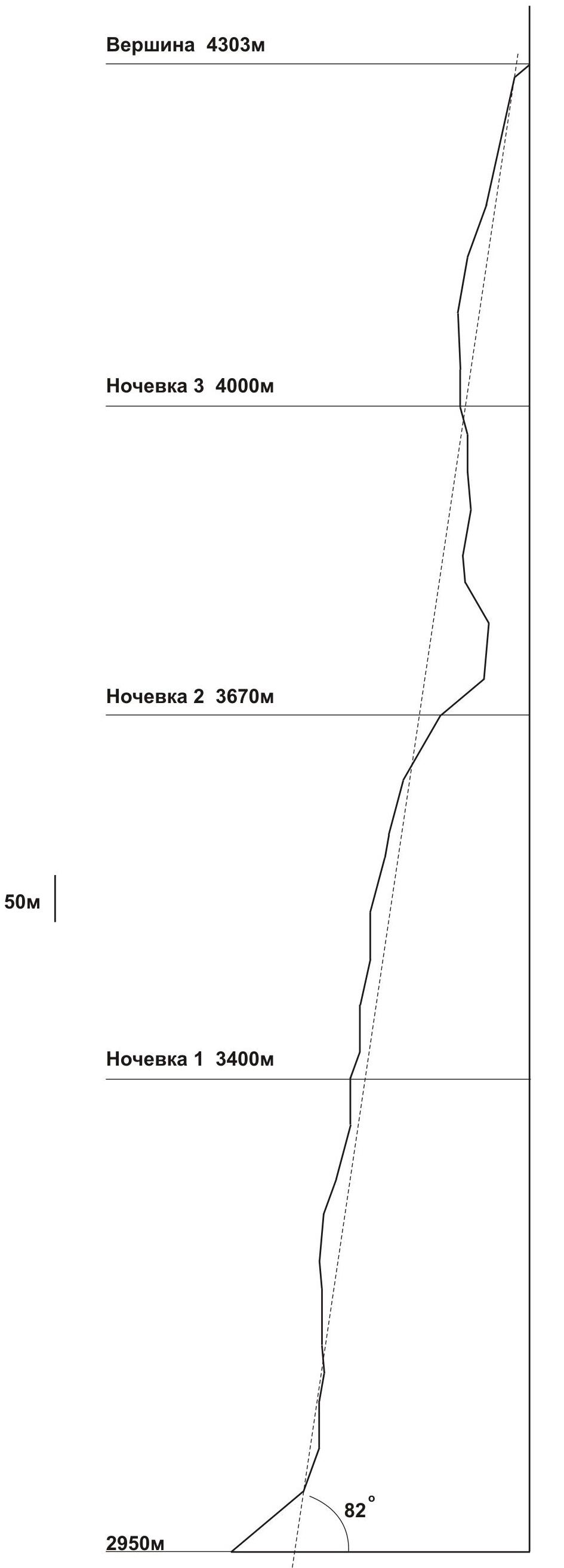
| 3.9 | Average steepness of the wall section | 82° |
| 3.10 | Descent from the peak | descent via the southwestern ridge and further down the wall and talus slopes to the southeast into the Pindor valley (approximately 4–5 category of complexity) |
| 3.11 | Additional route characteristics | there is practically no water along the entire route (snow in the cirque between R19–R20), water must be carried |
| 4. Characteristics of the Team's Actions | ||
| 4.1 | Time of movement (team's moving hours, indicated in hours and days) | August 1 — 13 moving hours (6:00–18:55), 2950 m–3400 m; August 2 — 13 moving hours (5:30–18:40), 3400 m–3750 m; August 3 — 12 moving hours (6:30–18:30), 3670 m–4040 m; August 4 — 9 moving hours (6:10–15:15), 4000 m–4303 m. Total 4 days, 47 moving hours. |
| 4.2 | Overnights | 1st overnight on a ledge, lying down, altitude 3400 m; 2nd overnight on a ledge, lying down, altitude 3670 m; 3rd overnight on a ledge, lying down, altitude 4000 m |
| 4.3 | Time spent on route preparation | - |
| 4.4 | Departure on the route | August 1, 2019 at 6:00 |
| 4.5 | Arrival at the peak | August 4, 2019 at 15:15 |
| 4.6 | Return to the base camp | August 5, 2019 at 10:00 |
| 5. Person Responsible for the Report | ||
| 5.1 | Full name, e-mail | Kudryashov Valery Sergeevich, kudr_fart@mail.ru |
Ascent Description
- Zamin-Karor 1st Western 4303 m
- Zamin-Karor 2nd Western 4525 m
- Zamin-Karor Central 4702 m
General photo of the wall. (July 30, 2019, taken from the base camp, altitude 2600 m)
Zamin-Karor 1st Western via NW wall 6A (O. Kapitanova), the team's route
- Zamin-Karor 1st Western via NW wall 6A (A. Samoded)
- Zamin-Karor 1st Western via NW wall 6A (S. Efimova)
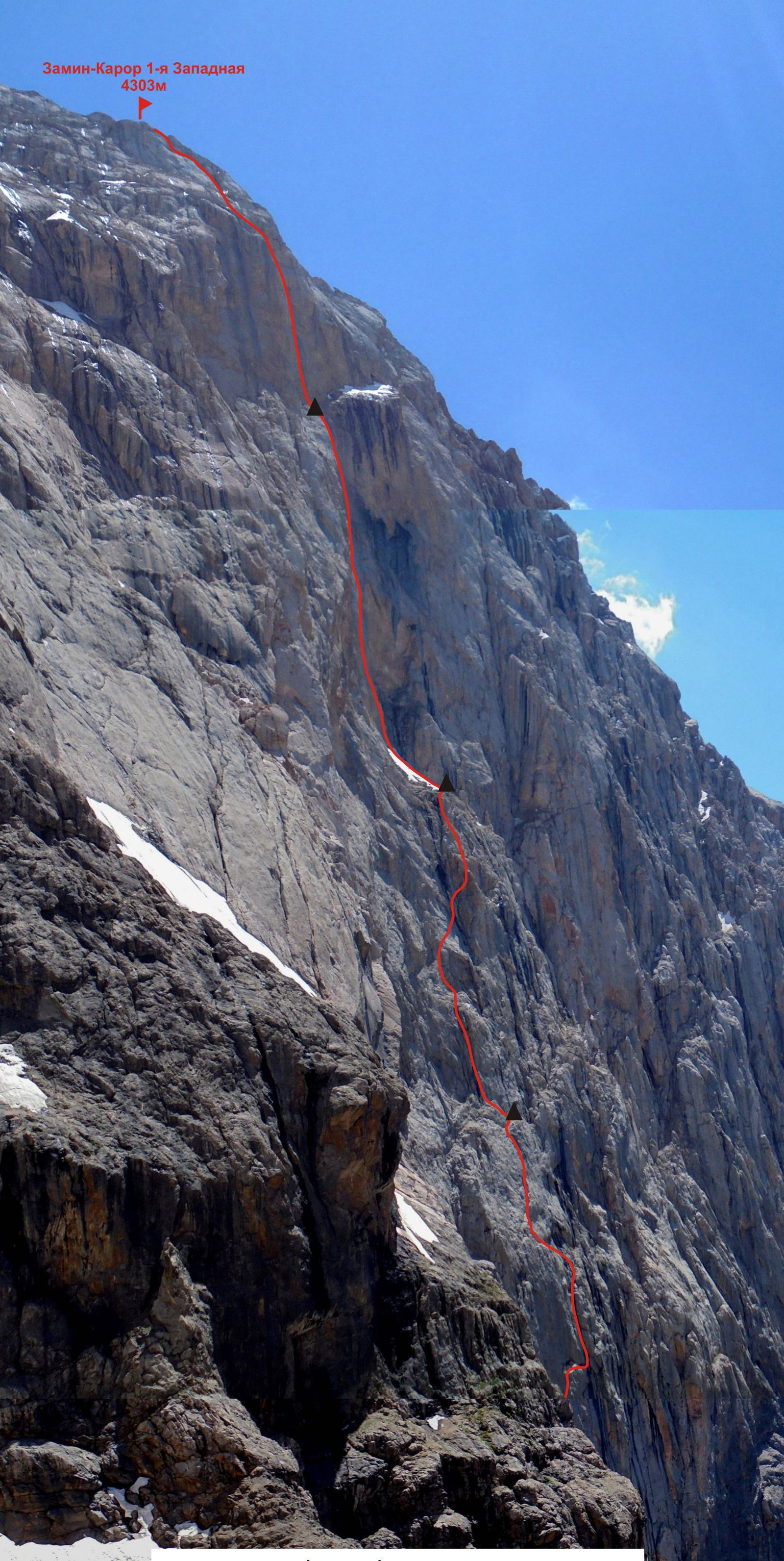
Photo of the route profile. (July 30, 2019, taken from the opposite rocky ridge, altitude 3300 m)
Graphical profile of the route.
Map of the Ascent Area

Logistics for getting to the area is quite simple. From Dushanbe to the village of Upper Margib, you can get to by a rented jeep (4 people with cargo) via the Dushanbe-Khujand highway, turning towards the village of Anzob after 100 km and further along the road along the left orographic bank of the Yaghnob river to the final destination.
The road is characterized by the following parameters:
- Distance: about 140 km
- Travel time: 3.5–4 hours
- Cost: within 1000 somoni
The road is mostly good.
From the village of Margib to the base camp at an altitude of about 2600 m under the northwestern wall of the Zamin-Karor massif, it takes 30–40 minutes to ascend along a pack trail with a load. In Margib, you can hire donkeys at a reasonable price. There is a store with a limited assortment. Currently, the green meadows in the base camp area are rented out by local residents from the state (for haymaking), so it is advisable to agree on the choice of base camp location with local residents to avoid conflict situations.
It takes no more than 1 hour to reach the start of the routes on the northwestern wall from the base camp.
Unfortunately, this interesting and accessible area with a sufficient number of diverse complex routes has been practically unvisited by climbers in the last 4–5 years.
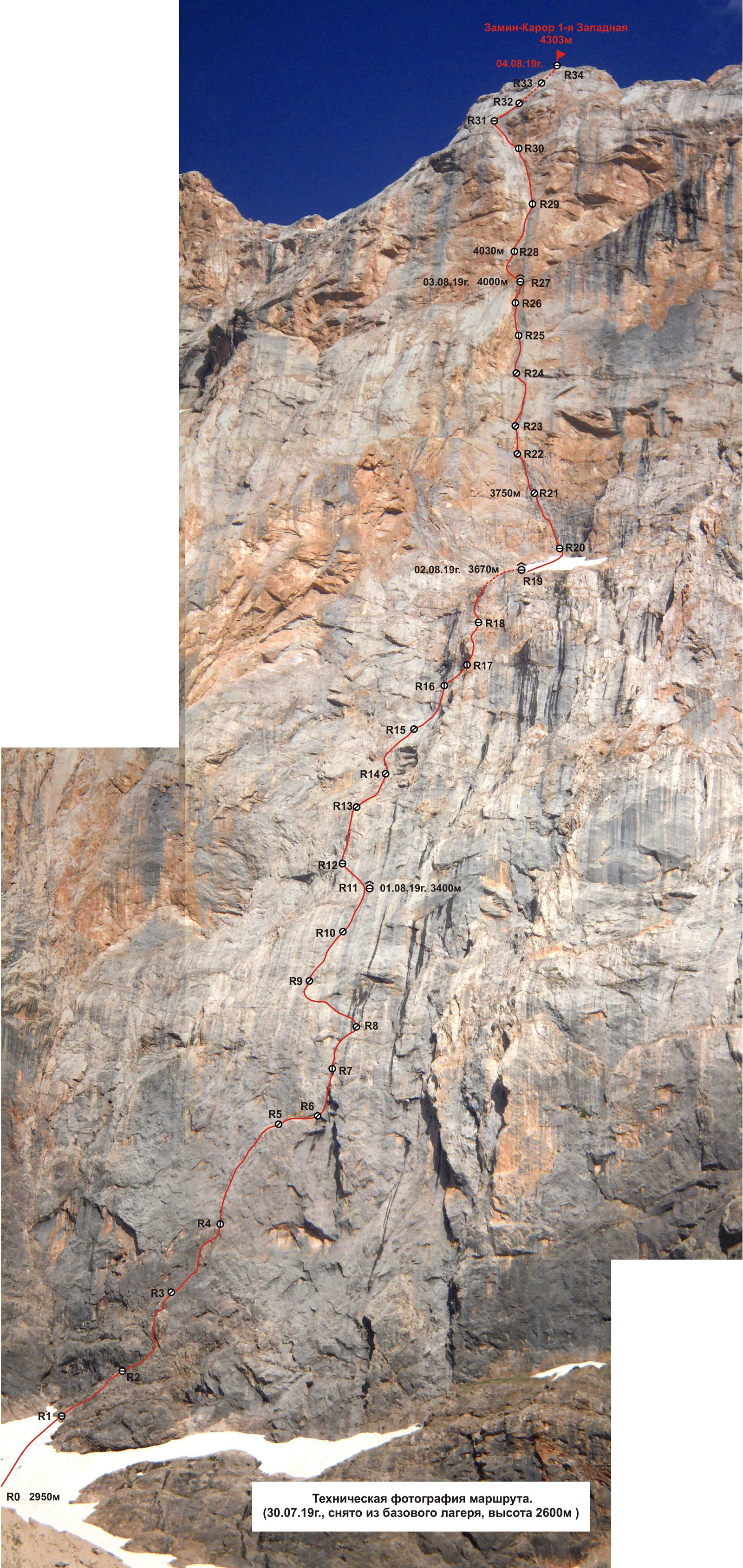
Technical photograph of the route.
Route scheme in UIAA symbols
| Section # | Anchors | Friends | Pitons, left earlier | Category of complexity | Length, m | Steepness, degrees |
|---|---|---|---|---|---|---|
| R0–R1 | II | 100 | 40 | |||
| R1–R2 | 3 | 4 | IV | 50 | 70 | |
| R2–R3 | 2 | 7 | V | 50 | 90 | |
| R3–R4 | 3 | 11 | V–VI | 60 | 80–95 | |
| R4–R5 | 4/2 | 1 | 10*/9 | VIA3 | 60 | 90–95 |
| R5–R6 | 1 | 3 | V | 20 | 90 | |
| R6–R7 | 8/2 | VIA1 | 30 | 95 | ||
| R7–R8 | 2 | 8 | VI | 50 | 85 | |
| R8–R9 | 3 | 3 | 1* | V– | 60 | 70 |
| R9–R10 | 2 | 8 | V | 60 | 75 | |
| R10–R11 | 3 | 5 | 2* | VI | 50 | 90 |
| R11–R12 | 6 | V | 30 | 70 | ||
| R12–R13 | 1 | 9 | VI | 50 | 85–95 | |
| R13–R14 | 4 | 3 | V+ | 50 | 75–80 | |
| R14–R15 | 5 | 6 | VI | 50 | 90 | |
| R15–R16 | 7 | 2 | V+ | 60 | 75–80 | |
| R16–R17 | 2 | 8 | VI | 30 | 80 | |
| R17–R18 | 1 | 10 | V | 60 | 70 | |
| R18–R19 | 11 | IV–III | 80 | 60 | ||
| R19–R20 | II | 40 | 60 | |||
| R20–R21 | 4 | 8 | V+ | 60 | 80–90 | |
| R21–R22 | 2 | 7/2 | VIA1 | 50 | 120 | |
| R22–R23 | 5 | 3 | VI | 30 | 95 | |
| R23–R24 | 11 | V+ | 50 | 80 | ||
| R24–R25 | 14/6 | VIA2 | 40 | 90–100 | ||
| R25–R26 | 6/3 | 9/2 | VIA2 | 40 | 90 | |
| R26–R27 | 3 | 5/1 | 1*/1 | VIA1 | 30 | 100–110 |
| R27–R28 | 7/2 | 4 | 1*/1 | VIA1 | 40 | 90 |
| R28–R29 | 8/6 | 12*/10 | VIA3 | 60 | 90–95 | |
| R29–R30 | 10 | 1* | V+ | 60 | 80 | |
| R30–R31 | 1 | 11 | V+ | 60 | 70 | |
| R31–R34 | 4 | 16 | V | 140 | 65–90 |
Characteristics of the team's actions.
Translation is stopped here as the last sentence is the end of the provided text.