- Assault team and observation group composition.
| # | Full Name | Year of Birth | Sports Rank | Responsibilities and Participation in Events |
|---|---|---|---|---|
| 1. | Lapshin L. L. | 1943 | MS | Team Captain and Coach |
| 2. | Lavrukhin V. I. | 1948 | CMS | Deputy Captain |
| 3. | Tkachev V. K. | 1937 | MS | Participant |
| 4. | Korzhavin A. P. | 1939 | CMS | Participant |
| 5. | Kim T. | 1947 | CMS | Did not participate |
| 6. | Filipov A. K. | 1947 | CMS | Did not participate |
Observation Group:
- Skrigitel A.
- Prisazhny B.
- Hardin V.
- Partenko L.
- Zhurkin V.
- Shlemchenko S.
Notes:
- Kim T. did not participate in the ascent due to a prolonged business trip.
- Filipov A. K. did not participate in the ascent due to illness.
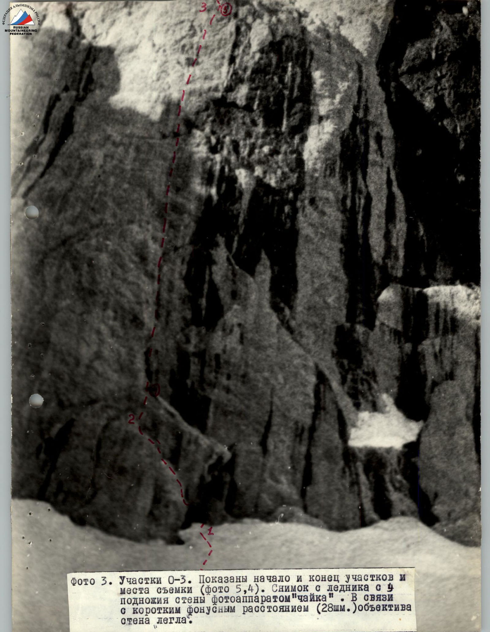
1. "Black Triangle"
July 10.
Section R0–R1
The beginning of the ascent up the "Black Triangle" wall is preceded by an ice-firn slope with a steepness of 40° and a length of 60 m.
It is traversed with periodic step-cutting on crampons and hook protection (2 ice hooks) with rope installation. The section is category 2B, covered in 30 minutes.
Section R1–R2
From a small (1×1.5 m) platform on dense firn, a transition is made onto the rocks via a snow-ice bridge (3 m) over a crevasse separating the rocks and ice. The transition to the start of the ascent up the wall occurs along an intermittent ledge 30 meters long. The ledge is wide (30–40 cm), gently sloping (up to 30°), smooth, monolithic, and crosses the rocks almost horizontally. It is clearly visible from below. It is interrupted by three sheer walled sections of smooth rocks 2–3 meters high.
The most challenging part is entering the ledge. It is done by traversing 5 m of slightly negatively inclined rocks with overcoming a sheer wall 5–6 m high. The overall difficulty category is 5A. It is traversed by free climbing by the first climber with rope installation. On the traverse of negatively inclined rocks, two ladders (2×3 steps) are used for protection and traversing the section; 8 hooks are hammered in.
Complex elements of the route:
- Traversing 5 m of slightly negatively inclined rocks
- Overcoming a sheer wall 5–6 m high
- Free climbing category 5A
- Rope installation by the first climber
- Use of two ladders (2×3 steps) for protection
- 8 hooks hammered in
Backpacks are pulled up on the lower part of the section (traverse, wall).
On the ledge, movement is done along the ropes with backpacks.
The overall steepness of the rocks in the section is 80°. The height gain is 20 m. The total length is 40 m (1×15+1×25).
The ledge ends under a sheer chimney-slot 10–15 cm wide, 10 cm deep, going vertically upwards. From here, the ascent up the wall begins.
The time taken to cover this section is 1.0 hour.
Section R2–R3 +
The ascent route goes almost exactly vertically towards the ice slope on the "triangle", clearly visible from the glacier. The start of the route is located slightly to the left of its center.
The average steepness of the section is 85–87°. The rocks are monolithic. The rock type is gray marble-like limestone with a thin darker surface film.
The film likely formed due to:
- water runoff down the wall and the carrying of fine silt particles from the higher-lying ledges,
- and atmospheric dust.
Due to these flows, the wall is significantly smoothed.
The rock relief is represented by a smooth wall with a very small number of small holds, smoothed, and a very small number of cracks. Every 20–30 meters along the wall, there are 6 bands of sheer and slightly negatively inclined rocks, each 15–20 meters high. All of them are cut by narrow (up to 30 cm) shallow (up to 30 cm) chimney-slots at the route passage points.
These chimney-slots are characterized by the following:
- The edges of these chimney-slots are represented by slightly destroyed (small form) rocks of low strength on the surface.
- At the time of passage, the slots were wet.
- Their tops are closed by plugs or monolithic rock sections.
- All of them are located with a slight deviation to the left of the plumb line and serve as movement guides.
At the same time, this path is the most logical.
Any other path would be significantly more difficult. There are no ledges or platforms on the wall suitable for receiving the group and organizing protection. All protection points are organized as semi-hanging; backpacks hang on hooks.
The presence of a thin surface film on the wall and moisture in the slots creates significant additional difficulties. The lack of sufficient cracks complicates protection organization.
The route is traversed by free climbing by the first climber with rope installation. Backpacks are pulled up throughout.
64 hooks are hammered in for protection, including 8 piton anchors. For passing plugs with strong deflection, ladders (4 steps each) are used four times.
The high sporting skill of the first climber allowed him to traverse most of the sheer sections by free climbing, without using artificial support points.
Climbers on the ropes use clamp systems and gripping knots, facilitating the passage of negatively inclined sections.
The total time taken for this section is 10 hours. Its length is 200 meters (5×40 m).
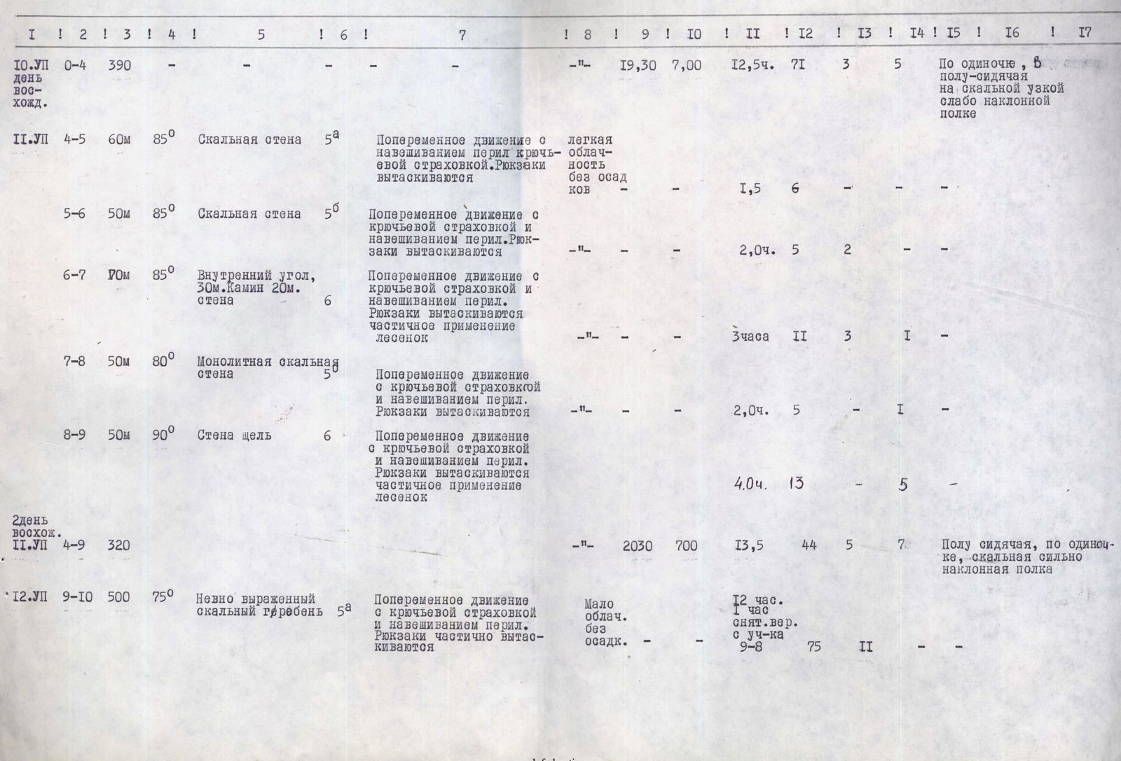
Section R3–R4
At the top of the monolithic rock wall, a snow slope begins with a steepness of up to 70°. On its left edge (by direction), there is a narrow (1–1.5 m) strip of superficially destroyed rocks (small form) in the form of a ledge with a steepness of up to 70°, slightly inclined (up to 20–30°), going left upwards.
The ledge in its upper part turns left by traverse, narrowing (up to 30–40 cm). Its steepness decreases to 50°. Along the ledge, there are two small (up to 3 meters) rock walls, also made of destroyed rocks.
Above the ledge and from it downwards, there are monolithic sheer rocks. At the end of the ledge, which abuts sheer monolithic rocks, there is a small height (3 meters) rock detached from the wall.
The rock type in the section is marble-like limestone, category 4A, length 100 meters (3×30 m).
After two ropes, the group sets up a bivouac. Movement along the route: free climbing by the first climber, with rope installation.
Backpacks are not pulled up. The group took 1 hour to reach the bivouac.
12 hooks are hammered in, including:
- for bivouac organization — 8 pcs;
- rock hooks — 9;
- ice hooks (in rocks) — 3.
Section R4–R5
From the rock at the end of section R3–R4, the path is possible only straight up. The relief is a wall, sufficiently dissected, with a small number of "live" stones and a sufficient number of holds, cracks, and slots. The average steepness is close to 90°, with short (up to 1–1.5 m) slightly negatively inclined rocks. At the end of the section, there is a small (0.5×1.0 m) monolithic rock ledge, inclined (up to 20°).
The route is traversed by free climbing by the first climber, with rope installation.
Backpacks are pulled up. It takes 1.5 hours to overcome 60 meters of the wall (2×30) and 6 rock hooks are hammered in.
Category 5A.
Section R5–R6
From the ledge where all participants gathered, there are two options for further movement:
- The path upwards to the right. Initially, for about 150 meters, it seems completely passable.
But at the end of the relatively easy section, monolithic smooth rocks overhang the center of the wall over a significant (100–150 m) extent.
The group had previously identified a route from this point to the left, exiting onto the upper left edge of the "triangle".
The exit itself looked technically challenging but was expected to be compensated by an easier route on the upper part of the triangle.
From the ledge, a sheer smooth monolithic wall goes straight up. Its passage is facilitated by a crack going along an arc to the left upwards, allowing hooks to be hammered in for protection and used as additional support points.
The section was traversed by free climbing by the captain with subsequent rope installation.
Backpacks were pulled up. The rocks are monolithic marble-like limestone, with smoothed holds of scaly structure. Unlike the underlying rocks (section R2–R3), there is almost no film on the surface, which facilitates passage on friction.
The average steepness of the route is 85°, practically sheer. Climbing is very challenging; the presence of three cracks allows for reliable protection. Category 5B, section length — 50 meters (1×50).
7 hooks are hammered in, including 2 ice hooks in rocks. The time taken is 2 hours.
At the end of the section, there is a large (2×1 m) horizontal ledge covered with fine gravel, suitable for organizing a comfortable bivouac.
- There is no water nearby
- 2–3 meters below the ledge, there is fresh snow on small ledges
Section R6–R7
From the ledge, black streaks are visible above to the left, coming from overhanging rocks.
These are traces of snowmelt on a balcony, where the group is headed for a bivouac.
Directly from the ledge, a weakly expressed internal corner goes up in its left part, continuing the ascent. Its length is 30 meters, steepness — 80°, category 5B.
The rocks are monolithic marble-like limestone, allowing for wide use of friction during passage.
At the end of the corner, there are no ledges or platforms, and protection organization and reception of following climbers are done from small holds in a semi-hanging position.
The section is traversed by free climbing by the lead climber with rope installation. Movement along the ropes is facilitated by clamps.
Backpacks are pulled up. 8 hooks are hammered in for protection, including 4 ice hooks in rocks.
The rope is covered in 1.5 hours. The internal corner transitions into a 20-meter sheer chimney, narrow (up to 30 cm), wet, cutting through the rocks overhanging the protection point. The chimney turns into a weakly overhanging wall for 7 meters, exiting onto a narrow (0.1–0.2 meters) intermittent slightly inclined ledge 3 meters long.
The section is very challenging. Movement through the chimney is complicated by:
- moisture on the rocks,
- smoothness of the rocks,
- overall negative steepness.
The crack is very small. It is traversed by free climbing by the lead climber with partial use of ladders (2×4 steps); piton anchors (3 hooks) are used for protection. Movement along the ropes is facilitated by two clamps. Backpacks are pulled up.
The rocks are monolithic marble-like limestone, without a surface film.
Category 6B. The time taken to cover the rope (1×40) is 2 hours 30 minutes. The total time for the section is 3 hours. 13 hooks are hammered in, including:
- ice hooks in rocks — 3;
- piton anchors — 1.
Section R7–R8
From the narrow ledge where the climbers gathered, after examining possible options, a path straight up and to the left from its midpoint was chosen.
The relief is a monolithic rock wall with sharp holds directed downwards, without cracks. The steepness varies from 85° at the start to 70° at the end. Climbing is very challenging, rated 5B in difficulty.
There are no landmarks along the path. The section is traversed by free climbing by the lead climber, with rope installation and pulling up backpacks.
The rocks are monolithic marble-like limestone, without cracks; 6 hooks are hammered in for protection, including:
- 1 piton anchor.
The time taken is 2 hours. The section length is 50 m (1×50).
Section R8–R9
This is a key section on the route. From the narrow ledge at the start of the route, the further path is completely invisible.
Above the ledge, there are negatively inclined rocks overhanging. An ascent of 5 meters to the left using ladders for inspection led to nothing.
At the same time, it was known from observations from the glacier and the lower part of the route that there was a snow balcony, where a bivouac was planned on each occasion. From the lower rocks, it was guessed by black wet streaks on the rocks.
After inspection, it became clear that the only path was upwards to the right, starting from significantly negatively inclined rocks.
It is traversed along a slot (5 m) using ladders. Further, along a vaguely expressed slot, only on hands (5 m), a slight easing of the overhang is reached (steepness 80°). From here, a traverse to the right (10 m) is made along a completely sheer and smooth wall using piton anchors for protection and artificial support points, exiting onto a narrow (up to 10 cm) vaguely expressed slot (depth up to 5 cm) cutting through negatively inclined rocks vertically upwards (30 m). Along the edges of the slot, there are rare cracks for hammering in hooks. The slot is traversed by free climbing with rare (2 ladders) use of artificial support points in places of significant deflection. Movement along the ropes is facilitated by two clamps. Backpacks are pulled up.
The overall steepness of the section is 90°. The length is 50 meters. The estimated difficulty category is 6.
For protection and artificial support points, 18 hooks are hammered in, including 5 piton anchors.
The time taken to overcome the section is 4 hours. The time taken to remove ropes for the next day is 1 hour.
Section R9–R10
July 12, 1973. After the bivouac, the group removed the ropes installed on the section (1 hour) and continued the ascent.
Directly above the balcony and to the right of it, there are negatively inclined rocks overhanging. The identified and only possible ascent path is upwards to the left, onto the left (by direction) edge of the triangle. From the bivouac to the vaguely expressed edge, there were about 40 meters (1×40 m). Further, the path goes slightly upwards to the right along this edge. The nature of the relief changes sharply. Characteristic are the roughness and destruction of the rocks (large form). The overall steepness of the route remains high (75°). The micro-relief is represented by low (10–15 m) walls, sheer, sometimes slightly negative, or ledges of small (2–3 meters) height with a significant number of cracks. The walls alternate with good ledges or sections of slightly gentler rocks of small (2–3 meters) extent.
The rock type also changes — these are marbles and strongly metamorphosed limestones, mostly grayish-yellowish in color.
The section is traversed by free climbing with rope installation.
Backpacks are partially pulled up on sections of sheer and negatively inclined rocks.
After two days on the wall with maximum effort, the third day's ascent along the edge of the triangle allowed for some relaxation.
The presence of cracks and ledges allowed for good protection organization and полноценно resting during breaks between movements.
The significant width (up to 70 meters) of the edge allowed for choosing the most favorable ascent paths.
The entire section (10×50) was covered in 12 hours, exiting under the beginning of the first ice-snow ridge.
Category 5A. July 13. First hanging glacier.
Section R10–R11. Ice Ridge
The top of the traversed rock triangle connects with a hanging glacier to a rock tower further on the route. At the point of movement, the ice slope has the form of a vaguely expressed ridge with an average steepness of about 45–50°.
To the right (by direction) of the ridge, there are significant ice drops. To the left, these slopes are much shorter and overhang the rock wall. In places, the rocks are cut by ice, and near the ridge, there are small rock outcrops and ledges, allowing their use for protection organization. Later in the year, more extensive rock exposure is possible.
The ridge itself is not uniform in steepness. Sections of increased steepness (50°) are at the beginning (240 m) and at the end (140 m); in the middle part, the steepness is about 40°.
The total length of the section is about 240 meters (6×40 m). At the time of passage, the ice was largely covered with snow, from 2–3 cm thick on steep sections to 10–15 cm on gentler slopes. The presence of a snow cover significantly facilitated the passage of the lower steep slope.
It was traversed early (6:00 AM), when the snow was frozen to the ice. In the upper part of the section, the thawed snow already hindered movement; the section was traversed by the front climber in crampons with periodic step-cutting in the lower part and almost continuous cutting in the upper.
The rest of the participants traversed it along the ropes. Backpacks were not pulled up. For protection, 3 rock and 22 ice hooks were hammered in, including 12 screw-type hooks.
The time taken to overcome the first ice slope is 6 hours.
Category 4A. Rock tower.
Section R11–R12
At the end of the ice slope, there is a fairly wide ice crevasse, but in the left part, the junction with the rocks occurs without a crevasse, via a smooth ice transition.
The slope itself abuts the base of the rock tower. The tower is sheer; the rocks on its eastern side are significantly destroyed, on the western side — less so.
From the eastern side, a steep (up to 70°) ice narrow (2 meters) couloir ascends to the tower, halfway up, along a weak arc. The left part of the couloir is represented by a rock ledge, partially covered in ice. The ascent is made along this ledge (4×40+1×50+1×50). At the end of the rope, to the left on the wall, 10–12 meters below the ledge, there are ledges where the 4th bivouac was organized. The rocks in the section are steep (up to 75°), destroyed (small form) on the surface.
In places, there are ledges up to 2–3 meters, and walls with a steepness of up to 80° and a length of up to 10–15 meters.
Movement is everywhere complicated by ice accretion, which needs to be cut, and snow in the upper part, in a layer of 5–10 cm. The presence of stones requires cautious movement and work with the rope.
The section is traversed by free climbing with rope installation. Backpacks are pulled up on two sections of sheer rocks with ledges in the lower part.
The time taken is 9.5 hours, including 7 hours to the bivouac. 35 hooks are hammered in, including:
- 6 ice hooks in rocks.
The total length of the section is 260 m, category 5A.
July 14.
Section R12–R13
The arcuate ice ledge abuts the midpoint of the rock tower. At this point, it is completely sheer, with a weak negative inclination. To the right upwards, a sheer 100-meter gully goes, filled entirely with ice. To the left, after 15 meters of sheer rock cliff, the ledge continues as a visible constant wall with a steepness of up to 80°, with holds of superficially destroyed rocks.
During the route study from below, it was decided to move left here, where the rocks were expected to be less challenging. The only concern was not to cross the safety boundary from ice avalanches from the upper second ice slope.
Traversing left — easy stepped rocks covered in snow (10 meters), traversing a weakly negatively inclined wall (8 meters), and ascending a rock wall at 80° (15 meters) allows seeing the further path upwards.
Under a small platform where the group gathered, a steep (up to 80–85°) ice gully-couloir passes, intercepting ice drops and snow avalanches from the upper ice slope. At this moment (around 11:00), the first avalanches of warmed snow began, revealing shiny ice. The rocks are traversed by free climbing with rope tensioning.
The category of the section is 5B, the time taken is 2 hours 30 minutes. Backpacks are pulled up along the tensioned rope.
10 hooks are hammered in, including 3 ice hooks in rocks. The length is 33 m.
Section R13–R14
Snow avalanches, although not directly threatening the group's safety, required urgent ascent.
The further ascent path is possible only one — upwards along the rock gully-chimney with a steepness of 75°, partially filled with ice, 20 m, and further along a negatively inclined wall (6 m), a dry gully with a steepness of 70° and a length of 15 meters, exiting under overhanging rocks at the beginning of the ice slope.
The section is challenging, category 5B in difficulty; climbing with an average steepness of up to 75° is done with rope installation in 2.5 hours. Backpacks are pulled up. 7 hooks are hammered in, including 2 ice hooks in rocks.
Throughout this time, small avalanches came from the ice slope, collected by the nearby ice gully. Snow slippage was caused by warming (it was around 14:00). Snow fell during the bad weather before exiting onto the route. Remnants of partially thawed snow cornices from the winter period also broke off.
Although the avalanches did not directly affect the planned ascent path, it was decided to wait and traverse the remaining ice section the next day early in the morning.
The overhanging rocks above the ledge protected the group from all possible troubles.
For the next ascent, a rope was installed on a monolithic rock ledge under the ice slope, and a main protection point was organized.
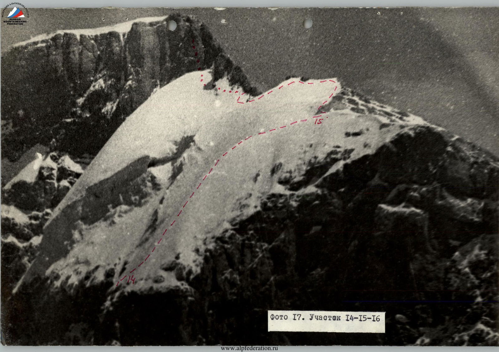
July 15. Second hanging glacier.
Section R14–R15
Exit onto the route at 5:00 AM.
The night frost had firmly gripped the thin layer of snow on the ice, allowing the first climber to ascend on the front teeth of crampons without constant step-cutting. For group reception, "bathtubs" were cut out.
Protection along the ascent path:
- screw-type ice hooks.
At group reception points:
- ice hooks of the usual type.
The section is traversed by the first climber on crampons with periodic step-cutting. The group ascended along the ropes with backpacks.
The slope's character changes with height in terms of steepness. The first rope (1×40) is an exit onto a vaguely expressed ridge, steepness 50°. The second rope (1×40) is along a vaguely expressed ridge with a steepness of about 40°. The third rope — again a slope up to 50°. At the end of the last ascent of a small snow-ice cornice (2.0 meters) — exit onto a snow platform with dense firn. The platform is located next to the ridge, to which a gentle (10–15°) snow slope leads, 100 m long.
The time taken for the section is 4.0 hours. Category 4A. After 5 hours, at 10:00, the group stood on the ridge.
18 ice hooks are hammered in on the route.
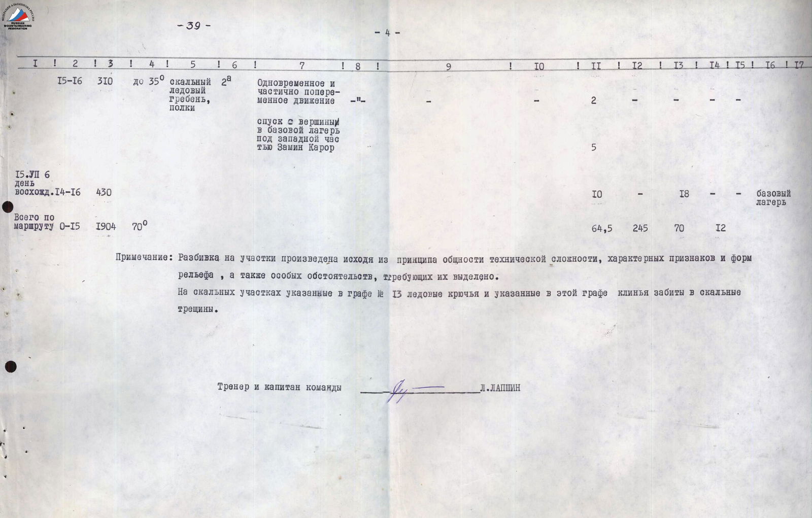
Section R15–R16 — Zamin-Karor Ridge
A wide rock-snow-ice ridge, 100 meters long, leads to the foot of the Eastern peak.
It is traversed simultaneously. The ridge of the tower of the Eastern peak breaks off with steep (up to 80°) walls, 80 meters high.
The tower is bypassed to the right (by direction) at a distance of 100 meters along easy rocks, with crossing an ice slope with a steepness of 30° and a length of 20 meters.
To the south from the peak, a wide (up to 2 meters) ledge goes. At its beginning, backpacks are left.
The ledge (100 meters) is traversed partially simultaneously, partially with alternate protection through outcrops.
The entire section is rated 2A category and is traversed at a leisurely pace in 2 hours.
The peak is flat, of significant extent, covered with fine gravel. From it, a view of the traversed route opens.
The descent to the south does not present difficulties. Easy rocks alternate with scree and snow-ice slopes.
Movement is simultaneous. Bypassing the canyon, the return to the base camp along a familiar path to all participants takes 3 hours.
| | | | | | | | | | | | | | | | | | | | | | | | | | | | | | --- | --- | --- | --- | --- | --- | --- | --- | --- | --- | --- | --- | --- | --- | --- | --- | --- | --- | --- | --- | --- | --- | --- | --- | --- | --- | --- | | 1 | 1 | 2 | 3 | 4 | 5 | 6 | 7 | 8 | 9 | 10 | 11 | 12 | 13 | 14 | 15 | 16 | 17 | | | | | | | | | |
17. Section R14–R16