Route Description 
First Ascent of Peak Yastreb  (Takob district of the Gissar Ridge)
Dushanbe. 1963
(Takob district of the Gissar Ridge)
Dushanbe. 1963
Description of the Peak and its Location
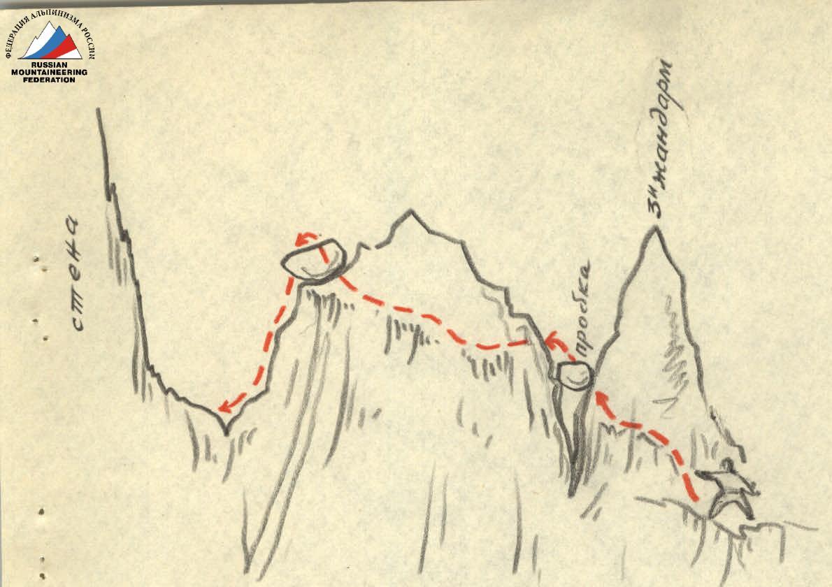
Peak Yastreb is located in one of the southern mountain spurs of the Gissar Ridge system, known as the Sanginavishta mountains. The most convenient approaches to the peak are from the tributaries of the Takob River — Taykutal and Drishint.
- Taykutal
- Drishint
Peak Yastreb is the highest peak in the Takob district. Its height is approximately 4300 m. The peak rises sharply among the surrounding peaks and has a characteristic silhouette with very steep rocky slopes and a double summit, which is why the local population calls it "Dushokha," meaning "two-horned."
The peak is composed of strong monolithic rocks, resulting in very steep slopes that drop off steeply in all directions with an overall steepness of 60 to 80°. The northern walls of the peak are particularly high and sheer. On the southern side, the monolith of the peak is cut by a steep snow-and-ice gully that leads to the ridge between the summits.
Access and Approaches to the Peak
The approach route to Peak Yastreb was discovered by the first ascent group after numerous reconnaissance efforts in May-July 1963. From Dushanbe, drive along the highway to the settlement of Takoba (42 km) and then along a mountain road leading north upstream along the Tuykutal River. The road is poor, but a car can pass as far as the kishlak of Pshambe (7 km). From Pshambe, the approach route to the peak follows upstream along the Tuykutal River on a pack trail. You should continue until the confluence of the Chatkolo stream with Tuykutal. Here, you need to turn off the trail to the left and ascend through the Chatkolo River gorge, as the Tuykutal gorge becomes impassable further on (the river flows through a narrow canyon with sheer walls).
In the Chatkolo gorge, the ascent is above the waterfalls, along steep grassy and rocky slopes with a significant gain in altitude. After two crossings of the stream, ascend to the grassy slopes with an eastern exposure between the Chatkolo stream and its left tributary. At the top of the grassy slope, you need to turn right (north) and continue ascending along an unnamed tributary of the Chatkolo River. Here, the gorge narrows sharply.
At the bottom of the gorge, snow lies until the end of July. The gorge leads to the Krugozorny Pass (altimeter reading 2700 m).
From the pass, you need to descend back into the Drishint River gorge. The descent is possible from the pass along a trail to the left (west), traversing above the rocks and emerging onto a steep snowfield, which can be descended to the bottom of the gorge (snow and snow bridges remain here until September). The loss in altitude is about 200 m.
Then, you need to move upstream (north) along the broad Drishint River gorge; on the grass-covered moraines, there is a convenient area for setting up a campsite (altimeter reading 2500 m).
Ascent
R1.
The route from the campsite goes upstream through the gorge, initially with a slight gain in altitude along snowfields, across snow bridges, and over moraines. On the moraine, near the bend of the gorge, there is a convenient spot for a halt near a spring.
R2.
At the bend of the gorge, the direction changes: straight up towards Peak Yastreb. The steepness of the snow slopes increases to 30° and then to 40°.
R3.
The snowfield narrows, with rock outcrops appearing on both sides. Upon reaching the walls of Peak Yastreb and the entrance to its gully ("snow tie"), we traverse to the right across a steep snow slope to the Eastern Pass ("1ХТ").
From the pass, the further route is clearly visible: the walls of the southeastern ridge and part of the crest. The route goes directly through the walls, bypassing sheer sections along a weakly defined ridge to the left, heading towards the black rocks, and then onto a steep crest.
R4.
The first (lower) rocky wall is bypassed on the left along the snow at the entrance to the gully. A steep snow ascent leads to a crevice (an inclined groove) that goes upwards to the right and ends at a small pillar above the first rocky wall. Steepness is 45°. Belays are alternating.
Note: The gully of Peak Yastreb is icy with a thin layer of snow on top. At the time of the first ascent, the snow layer on the ice was sufficiently thick and had good adhesion to the ice. Under unfavorable snow conditions, the first wall can be climbed along rocks of medium difficulty to the left of it. When traversing the gully, maximum caution and attention are required due to its high rockfall danger.
When traversing the gully, it is necessary:
- to exercise maximum caution
- to be attentive, as the gully is very rockfall-prone.
R5.
Along the inclined groove with rocks of medium difficulty, ascend to a narrow ridge. Steepness is 45-60°, the length of the groove is 50 m. The ridge is narrow (about 1 meter) and short (1.5 m); on the other side, it drops off sheer. Belays are alternating through outcrops. On a small pillar connected to the wall by a ridge, the first control cairn is built.
R6.
From the ridge, the ascent begins to the first wall. This section is difficult and is traversed in rubber boots without backpacks. The rocks are smooth with a grey sheen. Many rocks are weakly held.
The lower part of the wall is climbed initially along an inclined, nearly horizontal crack ("just enough to fit the toe"). There are no good holds.
The first climber is lifted to the crack with the help of a team member standing on the ridge below.
Further ascent is along large boulders that have separated from the wall, up to a weakly defined ridge that limits the wall on the left, and then straight up along it to a triangular outcrop, where a belay is organized. Climbing is very difficult; the steepness of this section is up to 80-85°. The height of the wall is 15 m. Pitons are driven into the lower and upper parts of the wall; in the middle part, over a segment of about 10 m, it is not possible to drive a piton (see diagram). To the right of the triangular rocky outcrop, there is a balcony where a belay is organized, and backpacks are pulled up. Behind the "plug" beyond the triangular outcrop, in a crevice, the second control cairn is built.
R7.
From the "balcony," a belay is organized for climbing the second wall. The wall is also climbed without a backpack, in sneakers or "Vibram" boots.
From the triangular outcrop, climb straight up to the overhanging section of the rocks.
The overhanging section is bypassed by traversing the wall to the left with piton belays. Then, again, climb upwards into an internal corner (two more pitons are driven). The height of the second wall is 40 m, steepness is 70-80°.
R8.
Further ascent is upwards along rocks of medium difficulty. The rocks are heavily destroyed, and great caution is required during climbing. The direction is straight up; the route is logical. Steepness is 60°. Belays are through outcrops. In the upper part of the section, before the wall, a piton is driven. The length of this section is about 40 m.
R9.
This section of the route is very steep and complex and must be climbed in rubber boots without backpacks. Some parts of the rocky wall are sheer and overhanging. In the upper part, the route gradually transitions into an internal corner. When climbing this section, caution is necessary due to the presence of "live" rocks, some of which are quite large.
Belays are with pitons. On a platform at the base of the internal corner, on a rocky ledge to the right of the route, is control cairn #3.
R10.
The further route goes along the internal corner. The internal corner is almost sheer, and in some places, it narrows into a groove. The overall height is about 80 m.
First, the lower half of the corner is climbed. In the middle part, there is a spot for organizing a belay, accommodating 3-4 people, and resting. Then, the upper half of the section is climbed, exiting onto the crest. Here, there is a small platform from which a belay is organized. The section is complex and requires a significant physical effort during climbing. The platform on the crest is formed by large boulders. From here, the further part of the route is visible, all the way to the first (eastern) summit. The crest has very steep slopes/walls on both sides (75-80°), and the crest itself has numerous pillars and dips.
R11.
Overcoming the first pillar is done by bypassing it on the left, traversing in the upper part under the sheer wall along weakly defined ledges. After overcoming the pillar, descend to a narrow ridge.
In a northeasterly direction, the ridge and the visible part of the crest drop off with completely sheer half-kilometer walls into the cirque of an unknown glacier.
R12.
From the ridge, climb up a small wall (3-4 m). Here, there is a convenient platform for camping, where the group set up a bivouac and stopped for the night. There is no water or snow nearby. On the platform, control cairn #4 is built.
By traversing to the left along ledges, we bypass the tower of the second pillar and exit onto a narrow ridge, ending with a third (small) pillar.
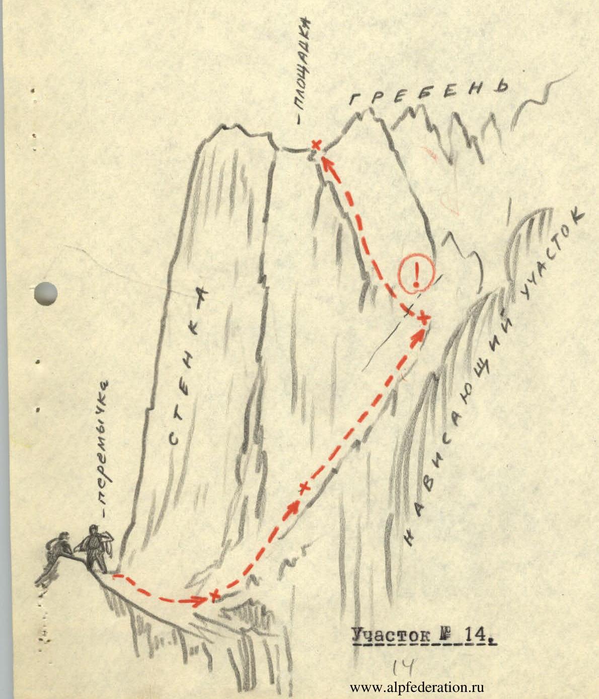
R13.
The third pillar is overcome as follows. First, bypass it above the wall to the left, through a crevice with a "plug," then straight up and onto the ridge. The ridge, dropping off on both sides with walls, is very narrow and abuts against a sheer wall ahead (the ascent of the crest).
R14.
Overcoming the wall. We traverse under the sheer section of the wall to the right. The wall here is also very steep and smooth, but there is an inclined crack that leads upwards onto the crest. Along this crack, with careful piton belays (4 pitons), it is possible to exit onto the crest. On the crest, above the wall, there is a small platform.
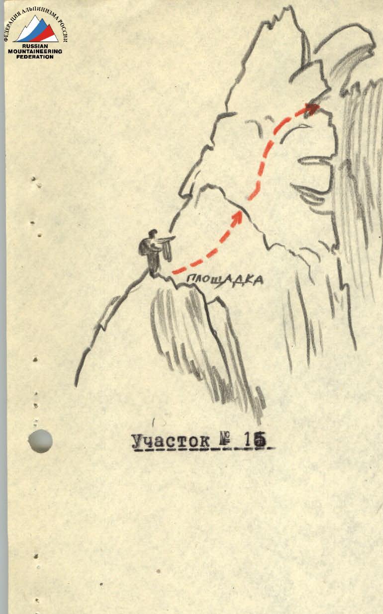
R15.
From the platform above the ascent of the crest, the further path goes straight along the axial part of the crest. The rocks here are monolithic with good holds. Up to the dip in the crest, movement is with alternating belays.
The drop is:
- To the right - not less than 700 m (cirque of the northeastern glacier)
- To the left - 200 m, a steep gully of the summit.
R16.
The dip in the crest is overcome as follows. Descend using a sports method 3-4 m down a smooth sheer wall (the last person descends on a double rope through an overhanging outcrop at the top) to a narrow ledge. Then, along the ledge, the wall is traversed above the dip onto a narrow ridge. Further:
- From the ridge to the right upwards, there is a short (1.5-2 m) shelf,
- Along the shelf, it is possible to exit onto a tooth,
- Then - onto the crest.
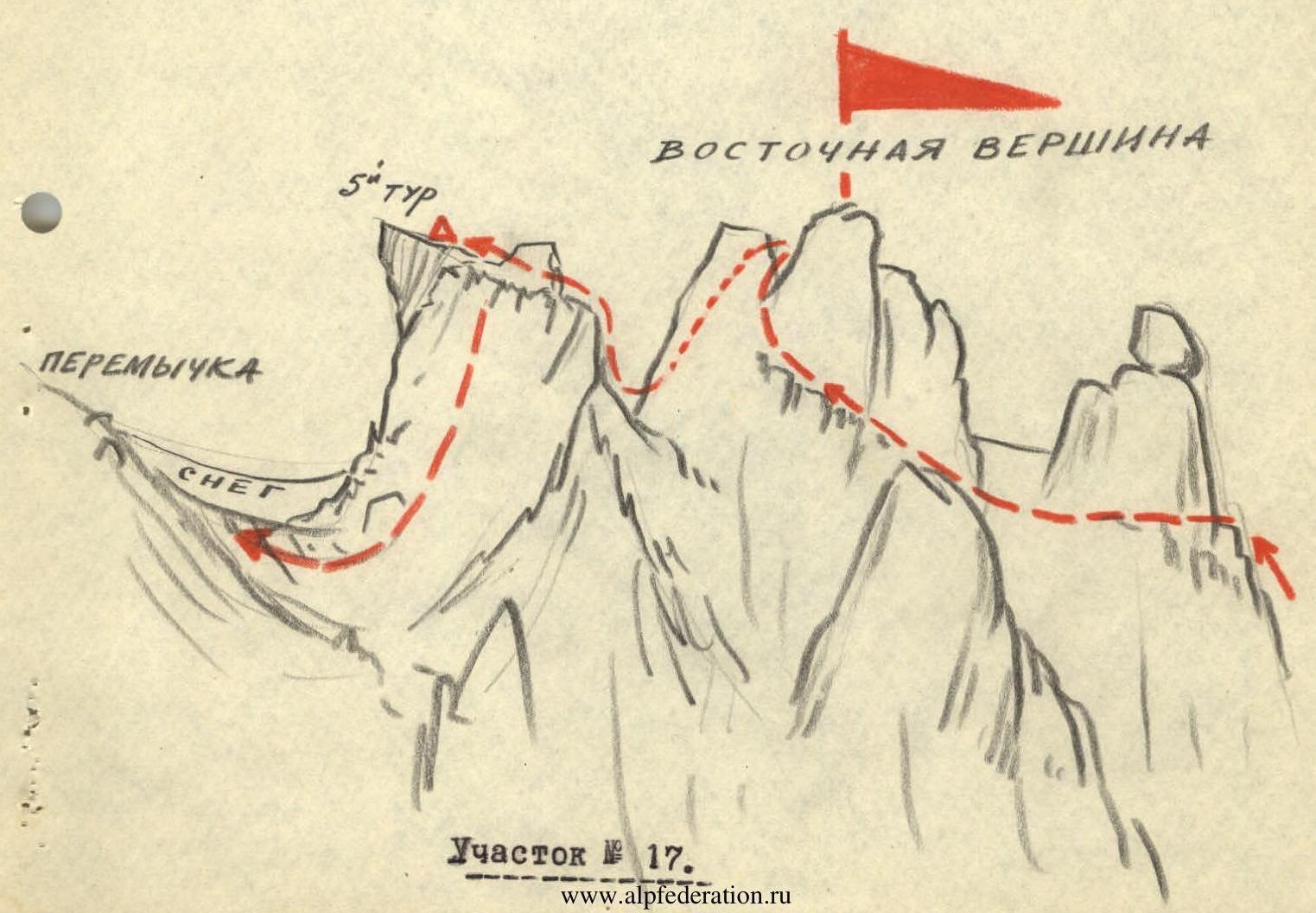
R17.
Upon exiting onto the crest, there is a good platform. Further to the eastern summit lead wide shelves (2 ropes). Small pillars are overcome without much difficulty. Belays are through outcrops.
On the summit, on a platform, a cairn is built.
R18.
From the summit, the descent to the ridge is not complicated. On the ridge, there is a convenient platform that can be used for camping. There is snow.
The ascent from the ridge along an inclined, wide shelf covered with rock debris - onto the middle pillar (40 m).
The pillar is bypassed on the left (40 m).
R19.
The route leads to a very narrow, sharp ridge with smooth walls dropping into abysses on both sides.
The ridge ends in an inclined tooth, behind which stands a low but smooth pillar without holds. The section is climbed with great difficulty and is very dangerous due to the difficulty in organizing belays.
From the tooth, you need to step over a crevice and climb onto the smooth pillar. There is nowhere to drive pitons. It is impossible to bypass the pillar.
On the pillar, a belay is organized.
R20.
The further path to the main (western) summit goes along the crest. The route always follows the axial part of the crest and does not present particular technical difficulty. The length of the section is about 80 m. Belays are alternating through outcrops.
The main (western) summit is clearly defined with slopes dropping off steeply in all directions. From the northern side, a snow-and-ice cornice hangs. At the highest point of the summit, there is a convenient, fairly large platform with large and sharp rocks protruding in the middle. Between them, a cairn is built, and a note from the first ascenders is left.
From the summit, a panorama of the district and the entire central part of the Gissar Ridge unfolds.
x × x
Descent
R21.
The descent from the summit is in the direction of the traverse - along the western ridge. To the right (from the north), the ridge drops off with sheer walls into the cirque of the glacier (drop of 500-700 m). To the left, there is a gully dropping off at an angle of 70-80°. The descent route is to the left of the ridge along a weakly defined internal corner, ending in a large inclined platform where snow lies.
The rocks are of medium difficulty. Belays are through outcrops.
R22.
Further descent is with an exit onto the crest, then along a small internal corner to the left of the crest, onto a wide shelf that leads back onto the ridge below the wall of the ridge. Belays are with pitons.
R23.
Descent straight down along the ridge through rocks of medium difficulty. The ridge drops off with a steepness of about 75°. Here, the descent is along a crevice onto a wide platform.
R24.
The platform is located on the shoulder of the ridge, which drops off on all sides with sheer walls. Further descent along the ridge is possible but the height of the wall is about 60 m, and there are no platforms along its entire height where intermediate belays could be organized. Here, it is necessary to move left along narrow, weakly defined ledges into the gully. In the gully, piton belays are organized. The gully is very steep (up to 70°) and rockfall-prone, so great caution is required during its traversal, and immediately after bypassing the wall, it is necessary to exit it.
R25.
From the groove of the gully, exit to the right onto rocks under the wall along ledges (30 m), and from here, begin the descent along small, narrow ledges straight down towards the snowfield.
Belays are with pitons and through outcrops.
R26.
After descending onto the snow in the gully (which widens sharply here), exit to the right along a steep snowfield, bypassing the walls of the rocky shoulder of the western crest. Alternating belays are through an ice axe. It is necessary to exit back onto the crest below the shoulder.
R27.
Further descent is along the ridge straight down through the middle part. The rocks are of medium difficulty, then easy. Belays are through outcrops, followed by simultaneous movement.
After descending onto a steep snowfield, it is necessary to traverse along it towards the ridge on a rocky ridge. Along easy rocks, descend to the lowest part of the ridge, where a cairn is built.
R28.
From the ridge, descend straight down along the snow of the southern glacier of Peak Yastreb. The steepness is initially up to 40-50°, then decreases to 30°. In the upper part, at the end of summer, ice may be encountered or formed.
Descend along the snowfields to the campsite. By right of the first ascenders, the group named the peak in honor of Cosmonaut #5, who at this time completed his unprecedented flight into space, Peak "Yastreb."
Comparing the route taken with all the routes of previous ascents in this and other districts, the group evaluates it as a route of category 4B difficulty, and the technical complexity of the sections of the ascent to Peak Yastreb along the southeastern ridge deserves an evaluation of a higher category of complexity (5A), but due to its insufficient length (18.5 working hours from the campsite), the evaluation of 4B seems more appropriate.
List of Participants in the Ascent of Peak "Yastreb"
Surname, First Name, Patronymic: Sports Rank: Home Address:
- KRYUKOV Viktor Ivanovich: 1st sports rank: Dushanbe, Komsomolskaya, 24, apt. 20;
- PEKARSKIY Valentin Vsevolodovich: 1st sports rank: Dushanbe, Popova #80, apt. 12;
- LINDT Ivan Ivanovich: 1st sports rank: Dushanbe, Aini #70, building 5, apt. 21;
- YAMPOLSKIY Eduard Yakovlevich: 1st sports rank: Dushanbe.
The description was compiled by:
/V. Kryukov/  /V. Pekarskiy/
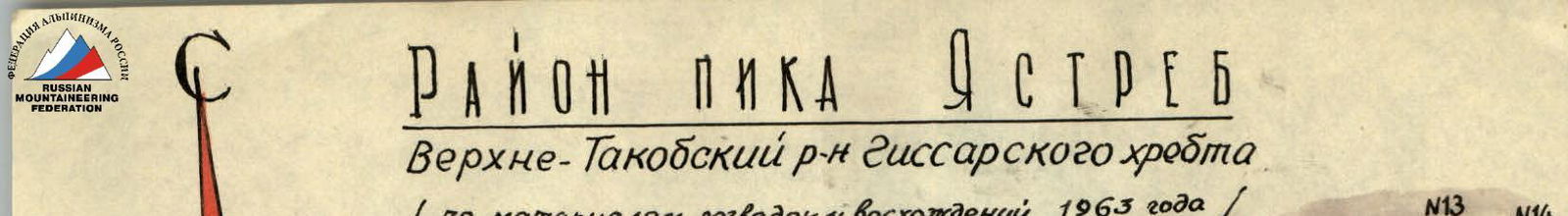
Area of Peak Yastreb
Upper-Takob district of the Gissar Ridge (based on materials from reconnaissance and ascents in 1963)
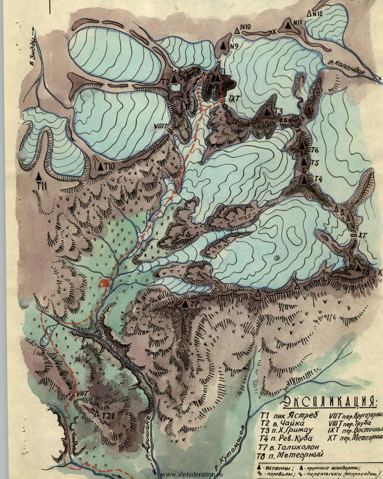
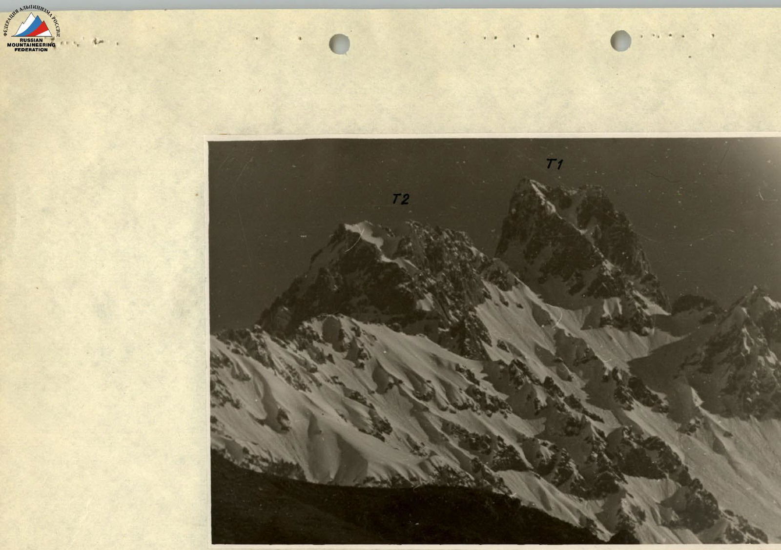
Photo #1. Peak Yastreb (T1) and Chayka (T2). Taken with a telephoto lens from Krugozorny Pass.

Photo #2. View from Krugozorny Pass to the north:
- T1 — Peak Yastreb
- T2 — v. Chayka
- T3 — p. Yulian Grimao
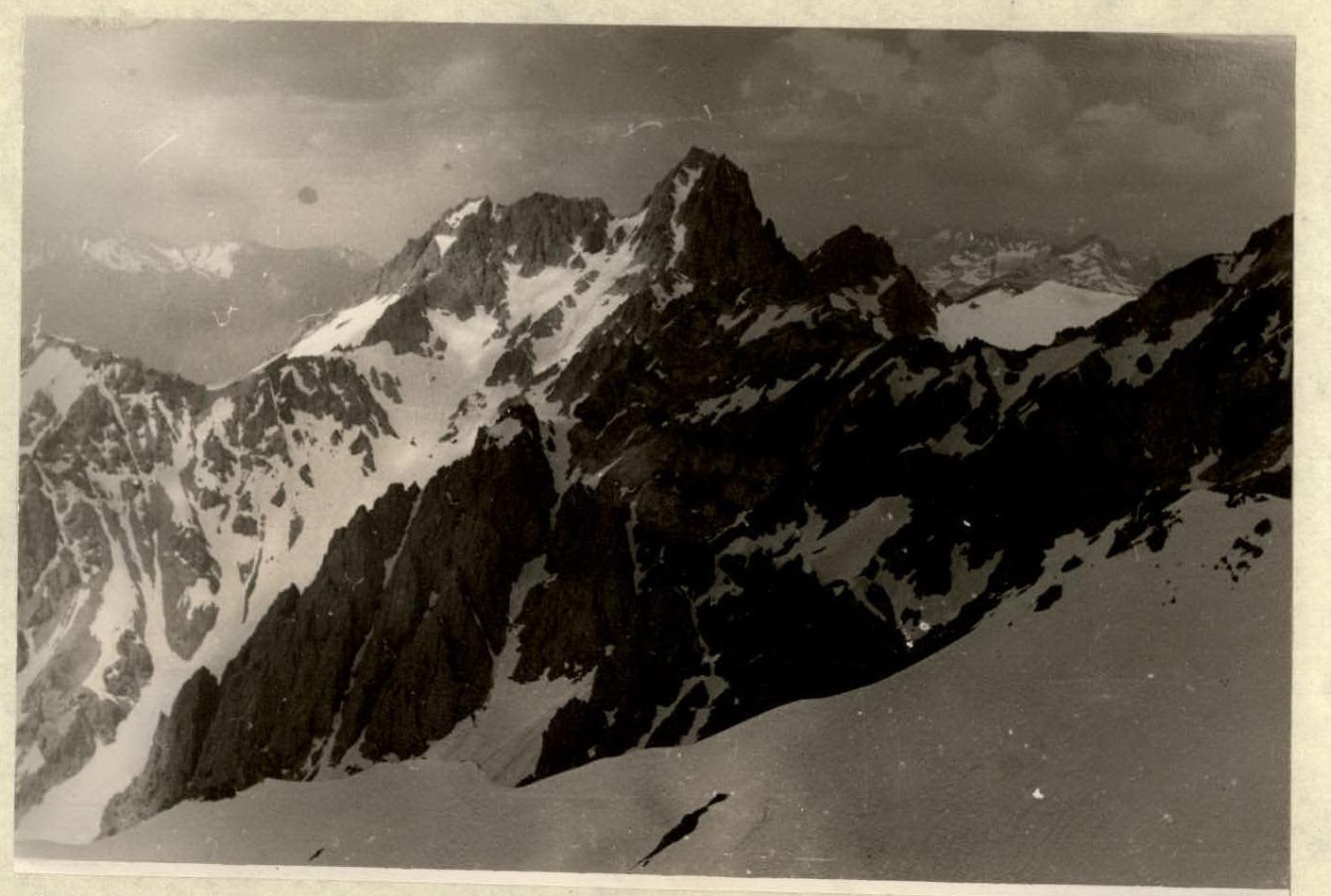
Photo #3. The massif of Peak Yastreb from the east (taken from p. Kh. Grimao T3).

Photo #4. Peak Yastreb. Route — traverse.
- A — Main summit
- P — Eastern summit
- Z2 — campsite
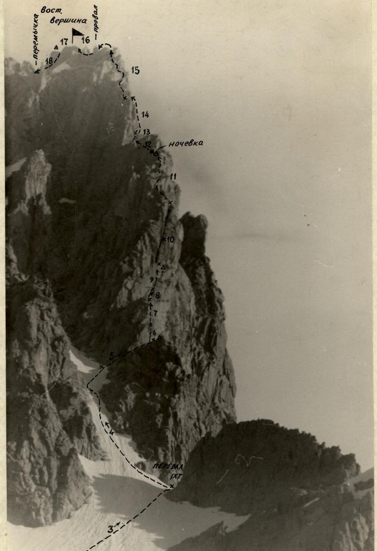
Photo #5. Southeastern ridge of Peak Yastreb. Beginning of the traverse. Numbers indicate route sections.
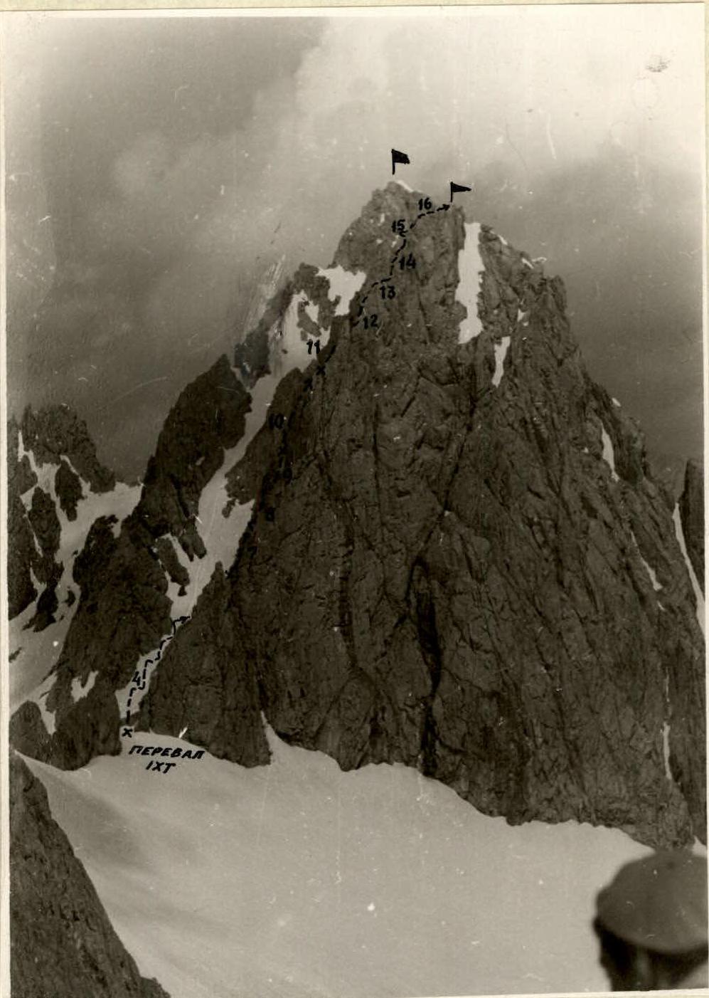
Photo #6. Southeastern walls of Peak Yastreb with the route.
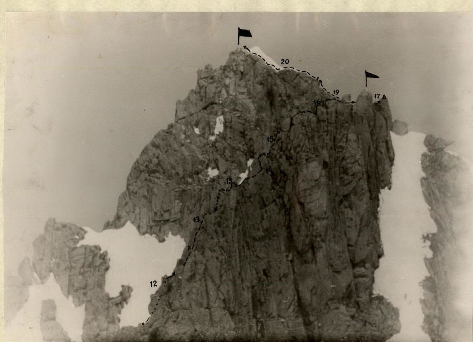
Photo #7. Upper section of the traverse route from the southeast.
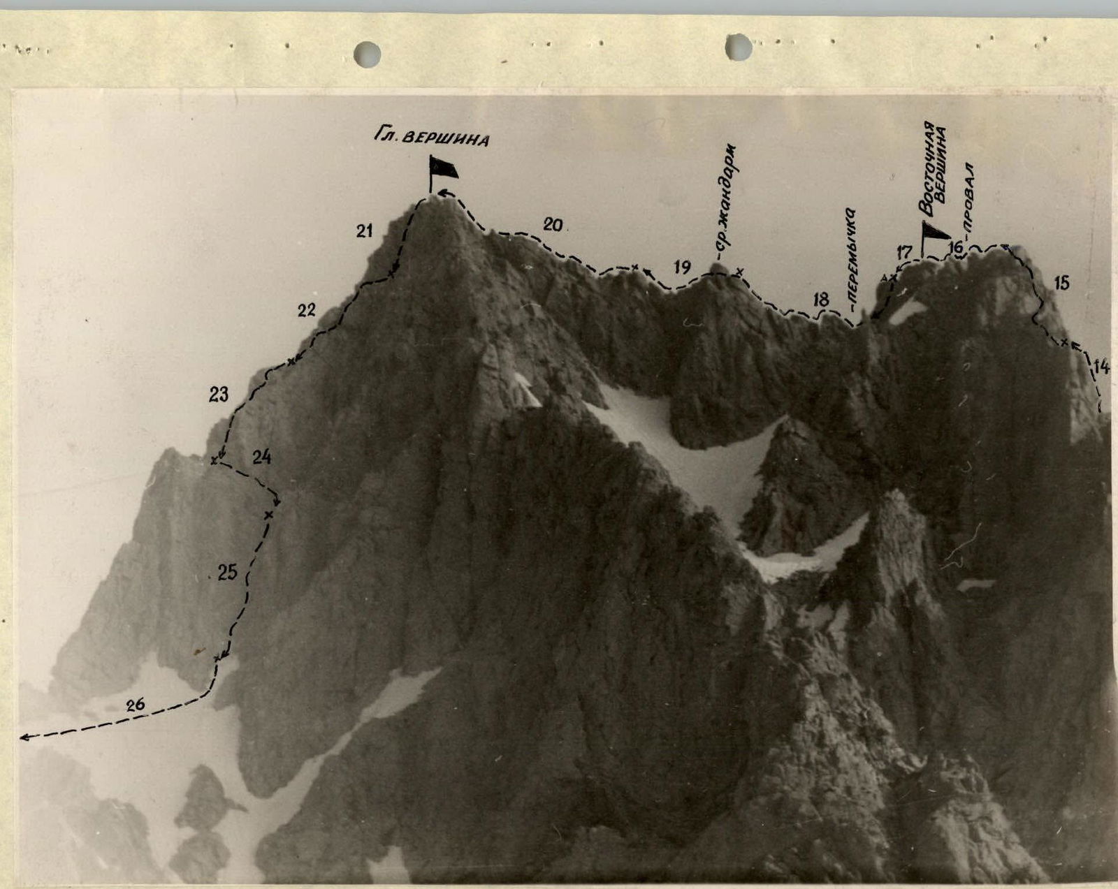
Photo #8. Peak Yastreb. Summits. Traverse route.
R13.