| № | Наименование | Данные |
|---|---|---|
| 1. | Class of ascent | — technical. |
| 2. | Ascent area | — southern spurs of the Gissar Ridge. |
| 3. | Ascent route with indication of peaks and their heights | — p. Named after XXI Olympic Games (conditional name) along the E edge, approximately 4B category of difficulty, height 3900 m. |
| 4. | Characteristics of ascent | — height difference — 500 m; average steepness — 50–60°; length of the difficult section — 65 m. |
| 5. | Pitons hammered: rock — 29 pcs., ice — 3 pcs. | — rock: 29 pcs.; ice: 3 pcs. |
| 6. | Number of travel hours | — eight hours. |
| 7. | Number of overnight stays and their characteristics | — there were none on the route. Possible overnight stay locations are described. |
| 8. | Team name | — team of climbers from the Voroshilovgrad Committee for Physical Culture and Sports under the regional Council of Deputies of Working People. |
| 9. | Surname, name, patronymic of the leader, participants and their qualification | — Rybakov Nikolai Petrovich, 1st sports category, leader. Gutsalenko Felix Felixovich, 1st sports category, participant. Zagirnyak Mikhail Vasilievich, 1st sports category, participant. Kruk Tatiana Petrovna, 1st sports category, participant. Mostovoi Ivan Grigorievich, 1st sports category, participant. |
| 10. | Team coaches | — Lyapin Z.F., Optov A.S. |
| 11. | Date of departure on the route and return | — July 23, 1976 — departure from the base camp. July 24, 1976 — ascent and return to the base camp. |
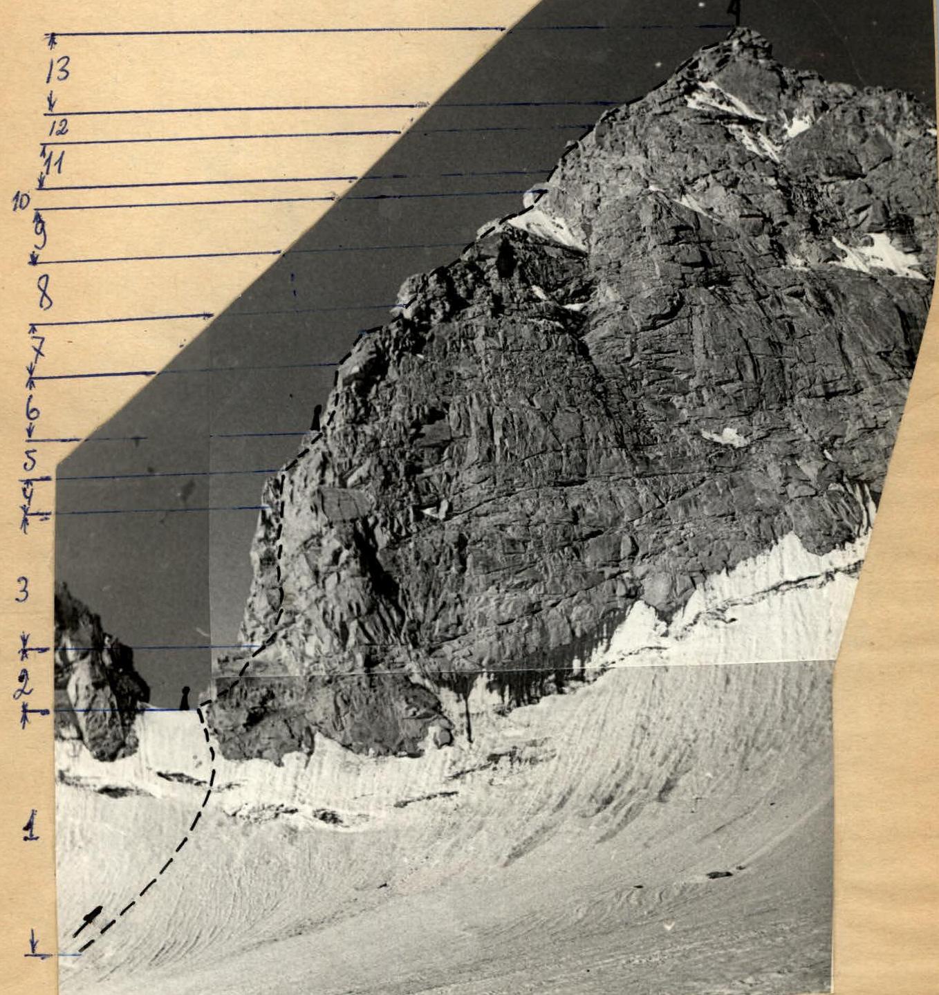
Peak named after XXI Olympic Games (View from the northeast). Conventions:
- group movement
- control point
Geographical location of the ascent area
- Ascent area — Pamir-Alay, Gissar Ridge.
- Name of the peak — named after XXI Olympic Games (conditional name of an unnamed peak).
- Height of the peak — three thousand nine hundred meters.
- Ascent route — along the eastern edge to the peak.
- Date of ascent — July 23–24, 1976.
The ascent area is located in the upper reaches of the Sioma River. The Sioma area is formed by a low spur extending south from the Gissar Ridge, which contains four towers of the Sioma Crown. From the Festivalnaya peak, the ridge is divided:
- the eastern part bypasses the Sioma valley from the east;
- and the western part — the Kadam-Tash valley.
To the north, the Sioma valley is bounded by a spur of the Gissar Ridge, which is a watershed between the Sioma River and the Maykhura River basins. Here is the beautiful peak Medvezhiy Zamok. Under the Big Sioma glacier, having regular outlines, rises the peak Shlem. To the west, the Sioma River basin is bounded by sections of the Gissar Ridge with peaks Kraynya, and also includes peaks Shpil and others. To the north of the peak Kraynya, in the Gissar Ridge, is the object of our ascent — p. Named after XXI Olympic Games.
Approaches to the Sioma area take about two days from the "Vorzob" tourist center along the Sioma River to its upper reaches. In the upper reaches of Sioma, on the Lukovaya clearing under the peak Medvezhiy Zamok, a base camp was organized, from which the first ascent to p. Named after XXI Olympic Games was made.
Brief description of ascent conditions in the area
The area of the upper reaches of the Sioma River has specific ascent conditions due to its great distance from the "Vorzob" mountaineering camp (about 25 km), which necessitates having a well-equipped base camp to provide full rest between ascents. The lack of roads in the valley forces the use of pack animals when transporting goods to the base camp. During the transportation of the base camp for the Voroshilovgrad Committee for Physical Culture and Sports, 20 donkeys were used, carrying 1.5 tons of cargo. The base camp was located on the left bank of the Sioma River on a green clearing under the peak Medvezhiy Zamok. The camp had everything necessary for a full rest for the participants, including a gas kitchen, a wide selection of food products, including fresh meat and vegetables, qualified medical care, etc. In addition, several participants had previously climbed in this area in 1968 and 1970, which allowed the others to quickly orient themselves without wasting time. The routes to the peaks are mainly rock. The rocks are warm, with sufficient holds for climbing and cracks for hammering pitons for belaying. The routes are not prone to rockfall, except for some. This nature of the routes allows the use of rubber footwear (galoshes, sneakers), significantly increasing the speed of passage without neglecting proper belaying and self-belaying. The climate in the upper reaches of the Sioma River is sharply continental: hot during the day, up to 40°C, and cool at night, but not cold, due to the low latitude of the area. This circumstance creates favorable conditions for overnight stays on the routes. The good weather is very stable — during the entire period of the gathering in Sioma from July 1, 1976, to July 27, 1976, there was not a single instance of precipitation or weather deterioration.
Organizational and tactical plan of ascent
The organizational plan provided for a uniform and sequential preparation of the entire team for the planned ascent, taking into account a gradually increasing load. To this end, training ascents were conducted.
The tactical plan provided for:
- on sections of free climbing — movement with periodic change of the lead;
- on difficult sections — belaying the leading climber on a double rope.
The group had:
- a "Vitalka" radio station;
- flares — in case of radio station failure.
Two-way radio communication was planned four times a day.
List of equipment used by the group on the route
-
- "Pamirka" tent — 1 piece
-
- Main rope — 3 × 40 m
-
- Auxiliary rope — 1 × 20 m
-
- Carabiners — 20 pieces
-
- Various pitons — 20 pieces
-
- Two-step ladders — 2 pieces
-
- Ice axes — 5 pieces
-
- "Shmel" primus stove — 1 piece
-
- Rock hammers — 2 pieces
-
- Down jackets — 5 pieces
-
- Down sleeping bags — 5 pieces
-
- "Vitalka" radio station — 1 piece
-
- First aid kit — 1 piece
-
- Flare gun — 1 piece
-
- Signal flares — 5 pieces
The weight of the daily food ration was 770 g. During the ascent, the group did not feel a shortage of equipment or food.
Description
Route of the first ascent to p. Named after XXI Olympic Games (conditional name) approximately 4B category of difficulty by a group of climbers from the Voroshilovgrad Committee for Physical Culture and Sports:
- Rybakov N.
- Mostovoi I.
- Gutsalenko F.
- Zagirnyak M.
- Kruk T. in the period from July 23, 1976, to July 24, 1976.
From the base camp upstream along the Sioma River: initially along the moraines, and then, turning right, exit onto the Big Sioma glacier. On the left moraine (orographically) under the peak Shlem — a platform for overnight stays. The approach from the base camp takes 3 hours. Cross the Big Sioma glacier in the direction of p. Named after XXI Olympic Games slightly to the right of the eastern ridge to a clearly defined gap in the ridge. The ascent to the gap goes along a steep 55–60° snow-ice slope 60 m high, intersected by a bergschrund in the upper part. The slope is about 60 m long. The bergschrund is overcome by a snow-ice bridge. In the gap — the first control point. From the gap, the general direction of movement is along the eastern ridge. From the gap, traverse left-upward 40 m, bypassing the overhanging wall, to an internal corner with black streaks. Along the left side of the internal corner 40 m vertically upward (difficult, piton belay) with an exit to the right onto a ledge. Further 40 m to the right-upward along destroyed rocks with slabs to a talus ledge. Along the ledge to the right — exit to the ridge under a 10-meter wall. Second control point. To the left, along a crack, overcome the wall and further 40 m, bypassing a jendarme with alternating piton belay, under a 5-meter wall. The wall is passed along a crack with piton belay. Further 40 m along the ridge of inclined smoothed slabs. Belaying through outcrops. Further, the path goes along a simple destroyed ridge under a 10-meter wall with a vertical crack, along which we ascend to the top of the wall (piton belay) and, having passed 80 m along the ridge with belay through outcrops, we approach the pre-summit 8-meter wall formed by monolithic rocks without cracks for hammering pitons (a psychologically difficult section). The wall is overcome by tense face climbing with thorough lower belay and further 4 ropes — along the pre-summit ridge to the peak. Descent from the peak along the northern ridge along simple rocks approximately 2nd category of difficulty to snow. Further, bypassing the peak from the north to the south along the western slope to a clearly defined saddle between the peaks Kraynya and Named after XXI Olympic Games. From the saddle, descend along a couloir to the Big Sioma glacier, sticking to the right side of the couloir. The descent to the overnight stay takes 4.5 hours.
The duration of the route is two days. Comparing the route taken with previous ascents to peaks of 4B category of difficulty: Dombay-Ulgen, Ak-Tash, Mekhnat, Shlem, Main Amanauz, Arg, the group evaluates the route as 4B category of difficulty.
Leader of the ascent: N. RYBAKOV Participants of the ascent: I. MOSTOVOI F. GUTSALENKO M. ZAGIRNYAK T. KRUK 
Table
of main characteristics of the route of the first ascent to Peak Named after XXI Olympic Games along the eastern edge.
- Height difference of the route — 500 m.
- Most difficult sections of the route — 65 m.
- Average steepness of the route — 50–60°.
| Date | Section № | Average steepness | Length of section | By relief character | By technical difficulties | By belay method | Weather conditions | Remaining travel hours | Rock pitons | Ice pitons |
|---|---|---|---|---|---|---|---|---|---|---|
| 24.07.1976 | R1 | 60° | 60 м | Snow-ice slope | Medium difficulty | Belay through pitons, ice axes | Clear | 1:30 | – | 3 |
| 24.07.1976 | R2 | 60° | 40 м | Large-block slabs, transition to an internal corner | Medium difficulty | Piton belay | Clear | 3:00 | – | 2 |
| 24.07.1976 | R3 | 85° | 40 м | Internal corner | Difficult climbing, using ladders | Piton belay | Clear | 1:30 | – | 12 |
| 24.07.1976 | R4 | 65° | 10 м | Small wall | Medium difficulty | Piton belay | Clear | 0:20 | – | 1 |
| 24.07.1976 | R5 | 40° | 40 м | Inclined talus | Easy climbing | Through outcrops | Clear | 0:10 | – | – |
| 24.07.1976 | R6 | 70° | 40 м | Inclined crack | Medium difficulty | Piton belay | Clear | 0:30 | – | 4 |
| 24.07.1976 | R7 | 85° | 5 м | Vertical wall with a crack | Difficult climbing using ladders | Piton belay | Clear | 0:20 | – | 5 |
| 24.07.1976 | R8 | 40° | 40 м | Rocky ridge | Easy climbing | Outcrops | Clear | – | – | – |
| 24.07.1976 | R9 | 40° | 80 м | Destroyed rocky ridge | Simultaneous climbing | Through outcrops | Clear | 0:15 | – | – |
| 24.07.1976 | R10 | 70° | 10 м | Wall with a vertical crack | Difficult rock climbing | Piton belay | Clear | 0:25 | 5 | – |
| 24.07.1976 | R11 | 45° | 80 м | Ridge leading to the pre-summit wall | Medium difficulty | Through outcrops | Clear | 0:35 | – | – |
| 24.07.1976 | R12 | 85° | 8 м | Monolithic wall | Difficult rock climbing. Psychologically difficult section. No cracks for hammering pitons. | – | Clear | 0:35 | – | – |
| 24.07.1976 | R13 | 45° | 160 м | Pre-summit ridge | Simultaneous climbing | Through outcrops | Clear | 0:50 | – | – |
| 24.07.1976 | R14 | 45° | 120 м | Descent from the peak along simple rocks to snow | Simultaneous | – | Clear | 1:00 | – | – |


Team captain: N. RYBAKOV
Coaches:
A. OPTOV
Z. LYAPIN

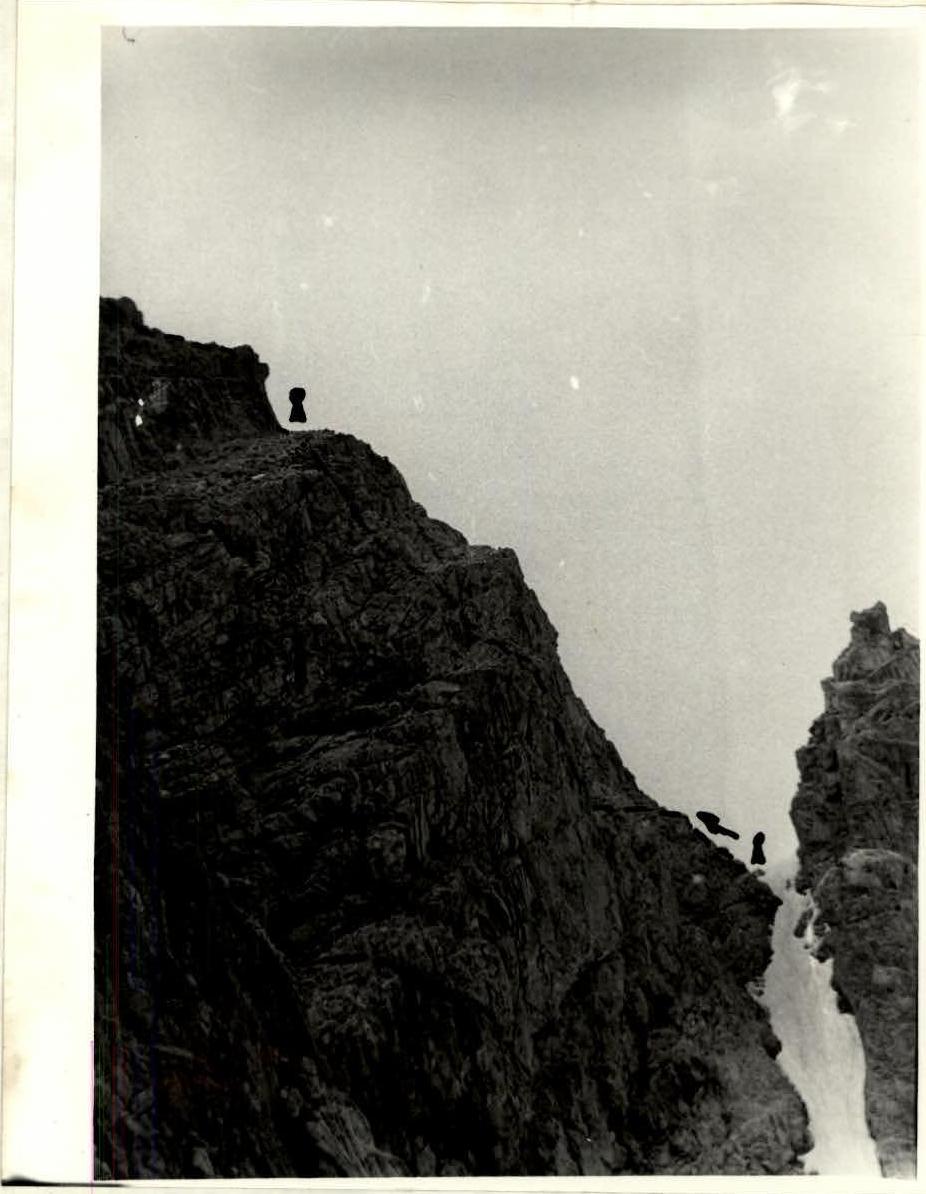
View of the route from the south. Saddle and beginning of the route.
- group movement;
- control point.