PIK GEOLOGOV 3B DIFFICULTY LEVEL
FROM THE SOUTHEAST
Peak Geologov is located in the Maykura area at the junction of three ridges. It is at the end of the Maykura glacier above the mine and is clearly visible from there. The height is about 4200 m.
Approach: You need to drive by car to the end of the road. Then, after walking for 15-20 minutes across the moraine, we reach the snow-ice slopes of the glacier and approach the beginning of the steep ascent to the ridge leading from the summit. We camp on the glacier. The time taken for the approach is 1.5-2 hours.
From the campsite, we ascend to the ridge via any snowy gap in the rocks and move to the right to reach the summit. From the last gendarme on the ridge, the start of the route is clearly visible, beginning with an ascent to the western spur of the ridge.
Section R1: We approach the start of a clearly visible steep ledge traversing the ridge from right to left via a snowy slope (possibly icy in autumn). The length of this section is 150 m, with a steepness of 20°. Tie in before reaching the rocks and bergschrund.
Section R2: Ascend to the ledge, which does not reach the snow, and move to the right onto the rocks from its beginning. We circumvent a patch of snow (4-5 m) above via the ledge with a steepness of 55-60° and a width of 50-60 cm, and reach the first belay point (60 m) on a good platform. The protection is via pitons (1-2) and rock features. The rocks are of moderate difficulty.
Section R3: Move directly along the ridge, veering to the right, to reach a connecting ridge under the start of a clearly visible negative wall on the ridge. The movement is alternating, with protection via rock features, and the length is 60 m.
Section R4: The negative wall is circumvented on the left. We ascend steep (70-80°) rocks with good holds (8-10 m) to reach a section with an overhang. The overhang (2 m) is traversed using an artificial aid point (ice axe) to reach an inclined platform, and then after a short (2 m) wall at its end, we reach a good platform. The length of this section is 20-25 m. The protection is via 3 pitons. The route is logical.
Section R5: The ascent to the second wall overhanging the platform begins to the right, reaching the start of a poorly defined ledge under the overhang (6-7 m). Then, traverse left and upwards along the ledge, which is sometimes interrupted (10 m), to reach a gully-wall and ascend it to the second platform. The length of this section is 20-30 m, with rocks of moderate difficulty, and protection via 2-3 pitons. There is ice available for drinking upon reaching the platform. The route is logical.
Section R6: The third wall, 20-30 m, is ascended directly. The steepness is 60-70°, but the holds are very good. The protection is via rock features. We reach the spur of the summit ridge.
Section R7: Along the gentle ridge, 60-80 m, via easy rocks, we reach a wide, gentle ring of large scree surrounding the summit dome. We approach the right part of the dome via scree (100 m) and ascend to the summit via easy rocks. Descent is via the ascent route.
The first ascent was made by a group of climbers in September 1964, consisting of:
Tkachyov V.K. — II sports category Shramko A. — III sports category Shramko G. — III sports category Ivanov K. — II sports category Tkachyov V. — III sports category Filipov A. — III sports category Solovyova T. — III sports category
The time taken from campsite to campsite is 10 hours.
Required equipment: main rope (preferably 60 m), auxiliary rope 40 m. Rock pitons — 4-5 pcs., ice axe — 1. Vibram boots are preferred. Other equipment is standard.
Compiled by:
Tkachyov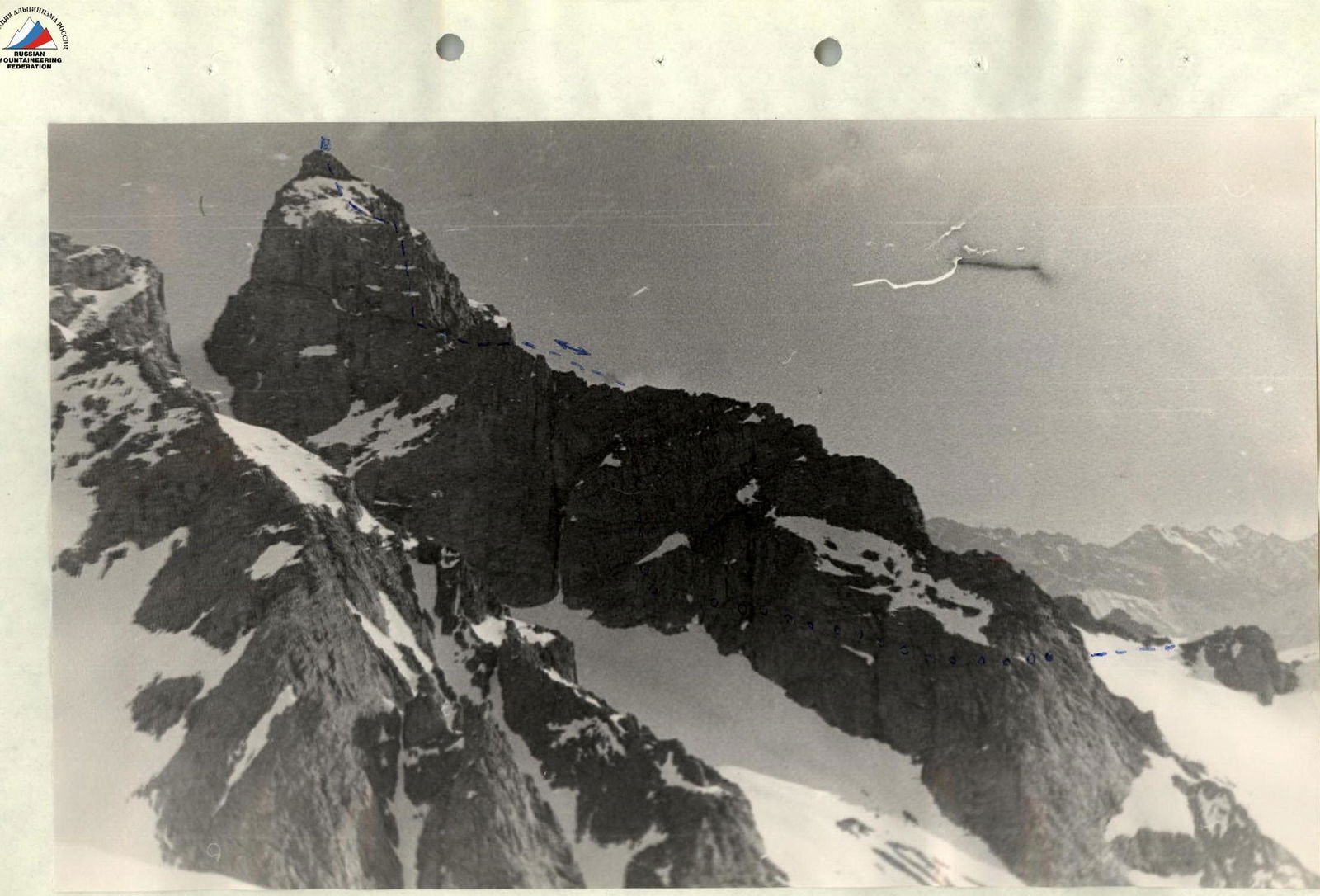
Peak GEOLOGOV and Zemlya pass GISSAR RANGE