PASSPORT
Ascents
-
Ascent class — technical.
-
Ascent area — Pamir-Alai, Gissar Ridge.
-
Peak — Pik Vladivostok (4257 m) via the North-Eastern ridge.
-
Proposed difficulty category — 3B.
-
Route characteristics: elevation gain — 687 m; length of category 2 sections — 282 m; » » category 3 — 303 m; » » category 4 — 65 m; » » category 5 — 23 m;
-
Pitons driven: for belays — 14 pcs. for creating artificial holds — 3 pcs.
-
Number of climbing hours — 12.
-
Number of nights and their characteristics — 1 overnight in a tent (on a moraine site below the Central pass).
-
Ascent participants:
- Vladimir Vladimirovich Polevoy — 1st sports category, leader;
- Vladimir Ivanovich Golovenko — 1st sports category, participant;
- Boris Fomich Zhuravlev — 1st sports category, participant;
- Vladimir Ivanovich Rudenya — 1st sports category, participant;
- Igor Konstantinovich Sharabura — 1st sports category, participant;
- Anatoly Ivanovich Tarasenko — 1st sports category, participant.
-
Team coach — Honored Coach of the Ukrainian SSR, Master of Sports of the USSR G. V. Polevoy.
-
Time and date of departure from the base camp under the Yaghnob wall — 16:00 July 13, 1977. Time and date of return to the base camp — 17:50 July 14, 1977.
GROUP LEADER V. POLEVOY
North-Eastern ridge of Pik VLADIVOSTOK
MAP of the Yaghnob area

Pik Vladivostok
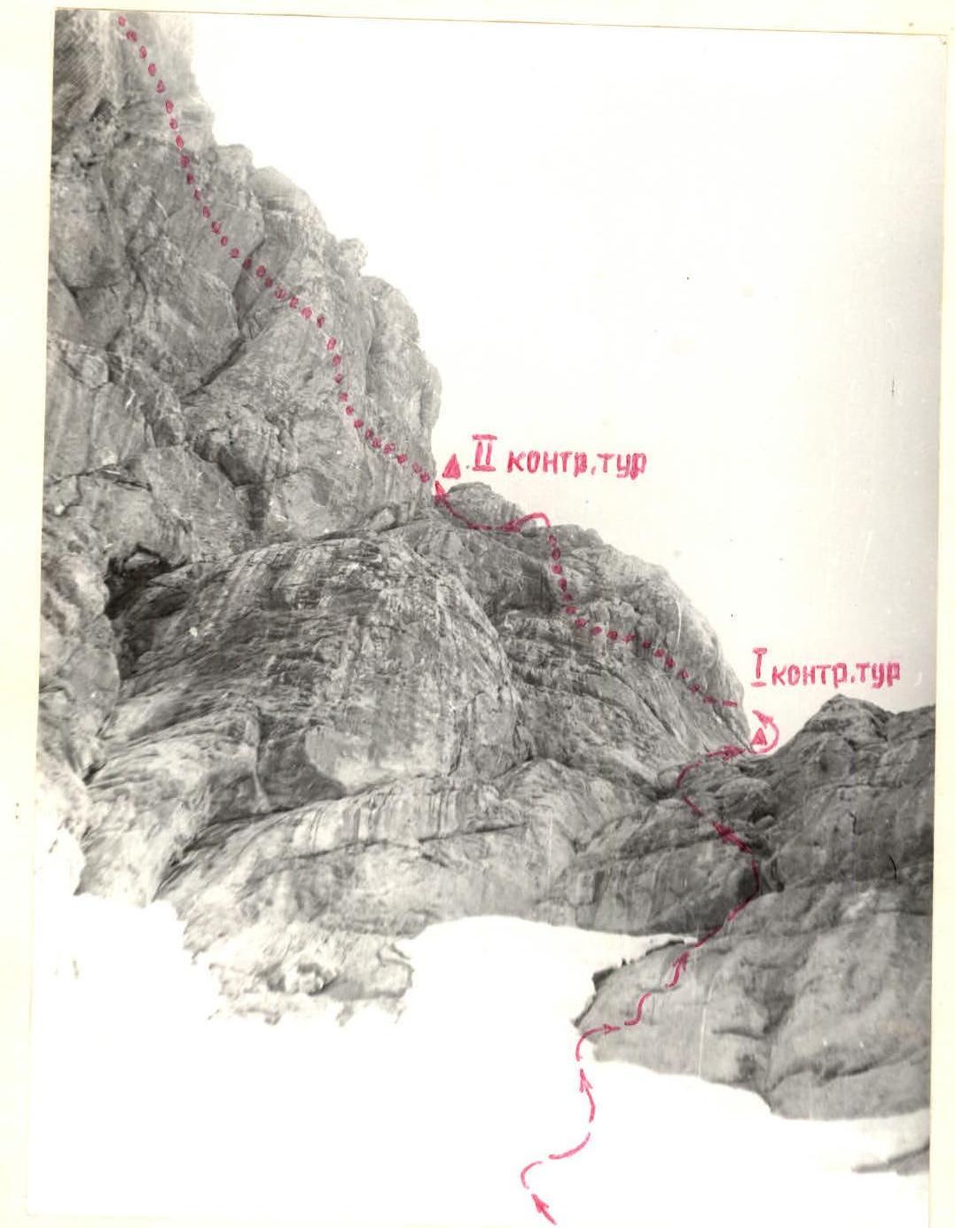
via the North-Eastern ridge, 3B category. The approach to the route from the base camp, located on the green terrace of the Yaghnob valley under the Yaghnob wall (Zamin Karor massif) above the village of Margib, is made through the Central pass (see the map of the Yaghnob area, fig. 1). The path from the base camp to the Central pass is described in the book by S. N. Sogrin "Pamir-Alai routes" (route No. 71) and takes 3–4 hours. From the pass, descend a snow slope with a slope of up to 40° down to the East for 50 m and then traverse the snow slope to the left (in the direction of travel) towards the talus shelf under the Pik Vladivostok massif (see fig. 2). From the talus shelf, go straight up the "ram's foreheads" with narrow shelves to the snow patch under the North-Eastern ridge of the summit. On the snow patch with a slope of 45°, climb 3 ropes straight up towards a sharp depression in the North-Eastern ridge towards the "ram's foreheads". On the oblique inclined shelves of the "ram's foreheads", climb 1 rope towards the depression in the ridge, then 10 m to the snow saddle on the ridge. Here, under the rock wall, is the 1st control cairn (on a small rock platform). From the saddle, go up to the left along the wall with a slope of 75° of medium complexity for 5 m (see fig. 3), then traverse to the right along a shelf for 10 m. Then, go up to the left along the wall for 8 m (difficult climbing) and along an oblique inclined shelf for 8 m under an overhanging "bald head" to the left, under which a large stone with a diameter of about 2 m lies on a shelf. The stone is bypassed to the right in the direction of travel, then climb the wall for 1.5 m (see fig. 4) to reach a narrow horizontal shelf, which leads to an oblique (from right to left) internal corner after 12 m. Climb up the left plane of the internal corner for 30 m (difficult section, rocks are wet, possible ice accretion). Here, we again reach the North-Eastern ridge. On simple, местами средней сложности, скалами подойти 15–20 м под кувшинообразный «жандарм». «Жандарм» обходится слева по ходу по полкам и уступам. Движение здесь одновременное. On simple, and in some places moderately difficult, rocks, approach 15–20 m under a jug-shaped "gendarme". The "gendarme" is bypassed on the left in the direction of travel along shelves and ledges. The movement here is simultaneous. Behind the "gendarme", we enter a wide internal corner, going from left to right under a rusty wall with dark streaks. A stream runs along the internal corner. Climb up the right plane of the internal corner for 30 m (rocks of moderate difficulty) and exit onto a rock shoulder behind the jug-shaped "gendarme". Here is the 2nd control cairn. Then, go up to the left under the wall, first along the internal corner for 20 m, then along a wide, slightly inclined (almost horizontal) shelf with a snow patch for 40 m to a not very wide couloir, going up to the left, with a slope of up to 50°. Climb up the couloir for 30 m ("live" stones!) and exit onto the North slope of the summit at the junction of the North-Eastern (along which the route passes) and North ridges of Pik Vladivostok. Then, go to the left in the direction of travel along talus shelves and easy rocks of the ridge ("live" stones!) for 80 m under a rusty wall, 10 m high and with a slope of 80°. This section is climbed through a chimney between the wall and a fragment to the right (difficult climbing) under a 3-meter wall. Climb up the wall (difficult climbing — key section!) to reach the summit ridge. Then, along the destroyed rocks, talus shelves, and inclined slabs of the ridge, traverse 160 m to the summit of Pik Vladivostok (simultaneous movement). Descent — via the ascent route. The ascent takes 12–14 hours from the base camp under the Yaghnob wall and 9–10 hours from the Central pass. There is water on the route.
Recommendations for climbers
A group of 4 climbers should have:
- at least 2 main ropes, 30–40 m long;
- a set of rock pitons, 12–15 pcs., including petal, universal, and channel pitons;
- at least 2 ice axes.
Description compiled by: (A. I. Tarasenko) January 30, 1978.
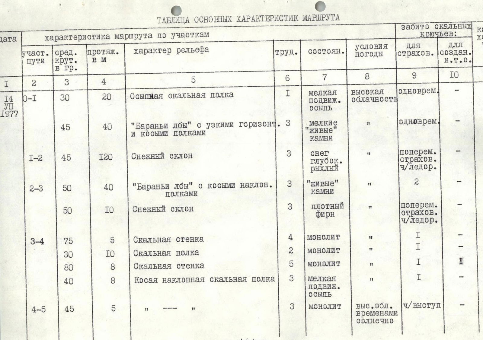
TABLE OF MAIN ROUTE CHARACTERISTICS
| Date | Section of the route | Average slope in degrees | Length in m | Characteristics of the route by sections | Difficulty | Condition | Weather conditions | Pitons driven for belays | For artificial holds | Number of climbing hours |
|---|---|---|---|---|---|---|---|---|---|---|
| July 14, 1977 | R0–R1 | 30 | 20 | Talus rock shelf | 1 | small mobile talus | high clouds | simultaneous | — | 5 min |
| 45 | 40 | "Ram's foreheads" with narrow horizontal and oblique shelves | 3 | small "live" stones | » | simultaneous | — | 15 min | ||
| R1–R2 | 45 | 120 | Snow slope | 3 | deep loose snow | » | alternate belay with ice axe | — | 30 min | |
| R2–R3 | 50 | 40 | "Ram's foreheads" with oblique inclined shelves | 3 | "live" stones | » | 2 | — | 20 min | |
| 50 | 10 | Snow slope | 3 | dense firn | » | alternate belay with ice axe | — | 5 min | ||
| R3–R4 | 75 | 5 | Rock wall | 4 | monolith | » | 1 | — | 5 min | |
| 30 | 10 | Rock shelf | 2 | monolith | » | 1 | — | 5 min | ||
| 80 | 8 | Rock wall | 5 | monolith | » | 1 | 1 | 15 min | ||
| 40 | 8 | Oblique inclined rock shelf | 3 | small mobile talus | » | 1 | — | 10 min | ||
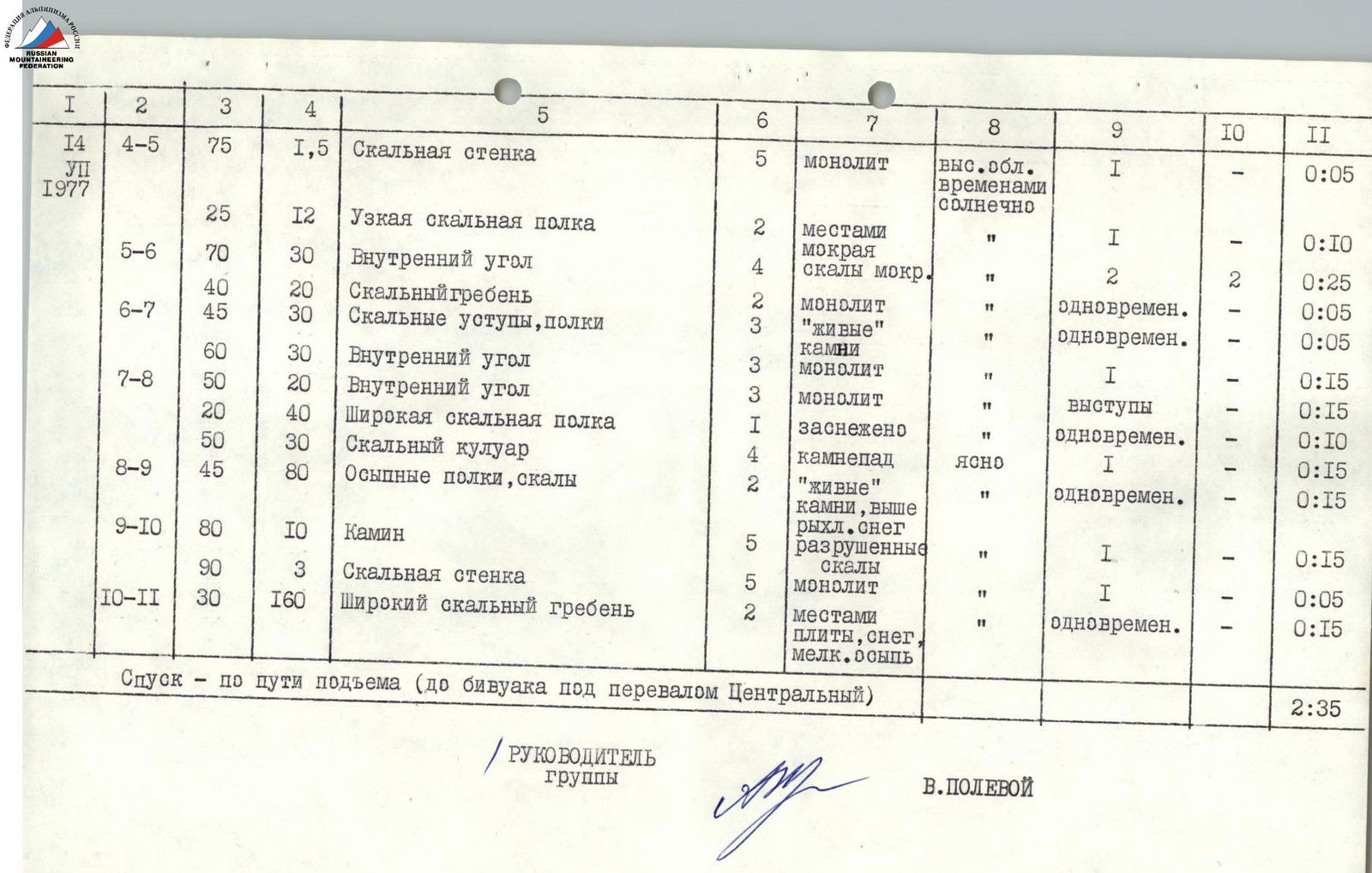
| R4–R5 | 45 | 5 | » » | 3 | monolith | high clouds, occasional sun | on a ledge | — | 5 min | |
| 75 | 1.5 | Rock wall | 5 | monolith | high clouds, occasional sun | 1 | — | 5 min | ||
| 25 | 12 | Narrow rock shelf | 2 | wet in places | » | 1 | — | 10 min | ||
| R5–R6 | 70 | 30 | Internal corner | 4 | wet rocks | » | 2 | 2 | 25 min | |
| 40 | 20 | Rock ridge | 2 | monolith | » | simultaneous | — | 5 min | ||
| R6–R7 | 45 | 30 | Rock ledges, shelves | 3 | "live" stones | » | simultaneous | — | 5 min | |
| 60 | 30 | Internal corner | 3 | monolith | » | 1 | — | 15 min | ||
| R7–R8 | 50 | 20 | Internal corner | 3 | monolith | » | ledges | — | 15 min | |
| 20 | 40 | Wide rock shelf | 1 | snow-covered | » | simultaneous | — | 10 min | ||
| 50 | 30 | Rock couloir | 4 | rockfall | clear | 1 | — | 15 min | ||
| R8–R9 | 45 | 80 | Talus shelves, rocks | 2 | "live" stones, loose snow above | » | simultaneous | — | 15 min | |
| R9–R10 | 80 | 10 | Chimney | 5 | destroyed rocks | » | 1 | — | 15 min | |
| 90 | 3 | Rock wall | 5 | monolith | » | 1 | — | 5 min | ||
| R10–R11 | 30 | 160 | Wide rock ridge | 2 | slabs, snow, small talus in places | » | simultaneous | — | 15 min |
Descent — via the ascent route (to the bivouac under the Central pass) — 2 hours 35 min.
GROUP LEADER V. POLEVOY
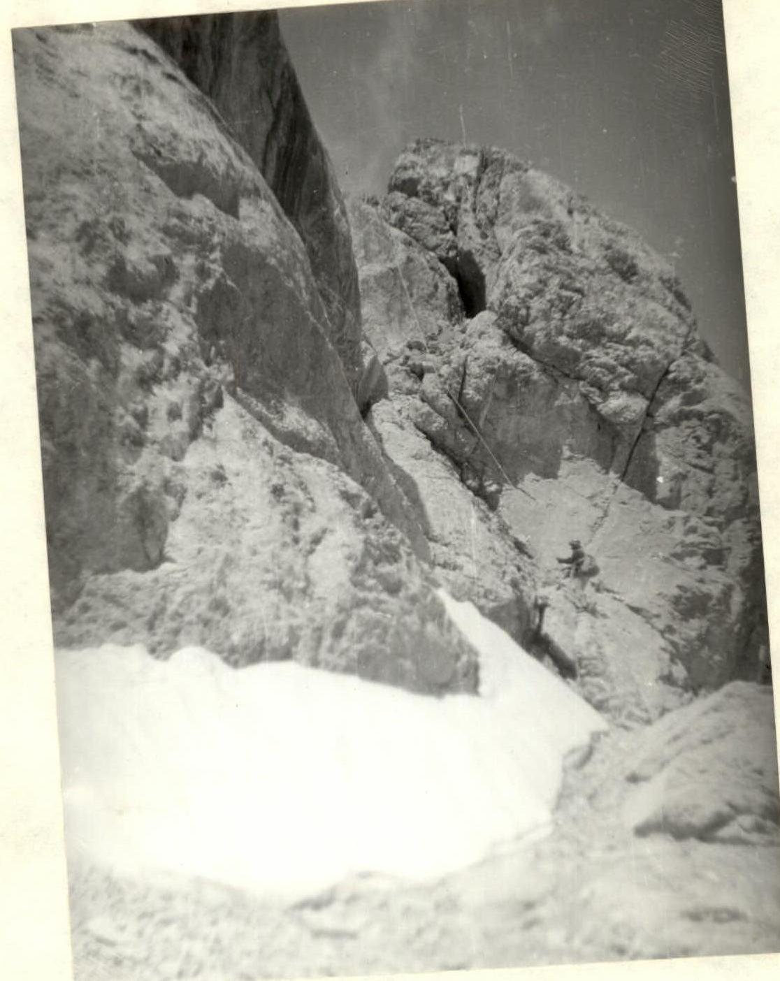
Section R7–R9
Snow-covered 40-meter shelf and rock couloir leading to the junction of the North and North-Eastern ridges of Pik VLADIVOSTOK


