Report
On the ascent of the group
From the Alpinism club of Magnitogorsk to the summit of Bivachnaya Gissarskaya 3700 m via the "crevice" of the Western wall
Magnitogorsk
2012
Leader of the first ascent in 1979: Viktor Ivanovich Igolkin. Leader and coach of the ascent in 1987: Viktor Ivanovich Igolkin
Leader and coach of the ascent in 2012 with the goal of restoring the route: Viktor Ivanovich Igolkin
455000 Magnitogorsk, Lenin Ave. 37, apt. 23, e-mail: avare.ivi@gmail.com, tel. (3519) 20-82-17, 8 909 093-65-21
Ascent Passport
- Region: Pamir-Alay, Gissarsky ridge (section 5.2)
- Summit: Bivachnaya Gissarskaya 3700 m via the "crevice" of the Western wall
- Proposed category of difficulty: restoration of the route, 4A*
- Character of the route: Rock
- Height difference of the route: 600 m. Length of the route: 970 m, including 160 m of 5th category of difficulty sections. Average steepness of the main part of the route — 68° of the entire route
- "Hooks" left on the route: total 3, including 4** bolted hooks
- Team's walking hours: 10 hours, 1 day
- Leader: Viktor Igolkin — Master of Sports. Participants: Alexander Pervushin — Candidate Master of Sports
Ekaterina Makarova — 1st sports rank
-
Coach: Viktor Ivanovich Igolkin — Master of Sports
-
Departure to the route from Big Lyudmila ("Zelenaya Polyana") — 6:00 July 10, 2012. Route started
- 8:00 July 10, 2013.
reached the summit
- 18:00 July 10, 2013.
Return to Big Lyudmila ("Zelenaya Polyana") — 20:30 July 10, 2013.
Descent from the summit via the Southwest ridge, 1B category of difficulty 11. Organization: Alpinism club of Magnitogorsk
- Responsible for the report: V. I. Igolkin 455000, Magnitogorsk, Lenin Ave., 37-23, e-mail: avare.ivi@gmail.com, tel.: (3519) 20-82-17, 89090936521
Magnitogorsk, Lenin Ave., 37-23, e-mail: avare.ivi@gmail.com, tel.: (3519) 20-82-17, 89090936521
-
- — first ascent made in 1979.
The most popular route was forcibly closed on the initiative of the head of the AUSB "Varzob" E. S. Abdulayev after the death of a group of instructors in 1988.
- — on the ascent, in difficult areas, bolted hooks were hammered in places where it is hard to organize belays. They do not affect the passage of the route, only for safety.
 .
.
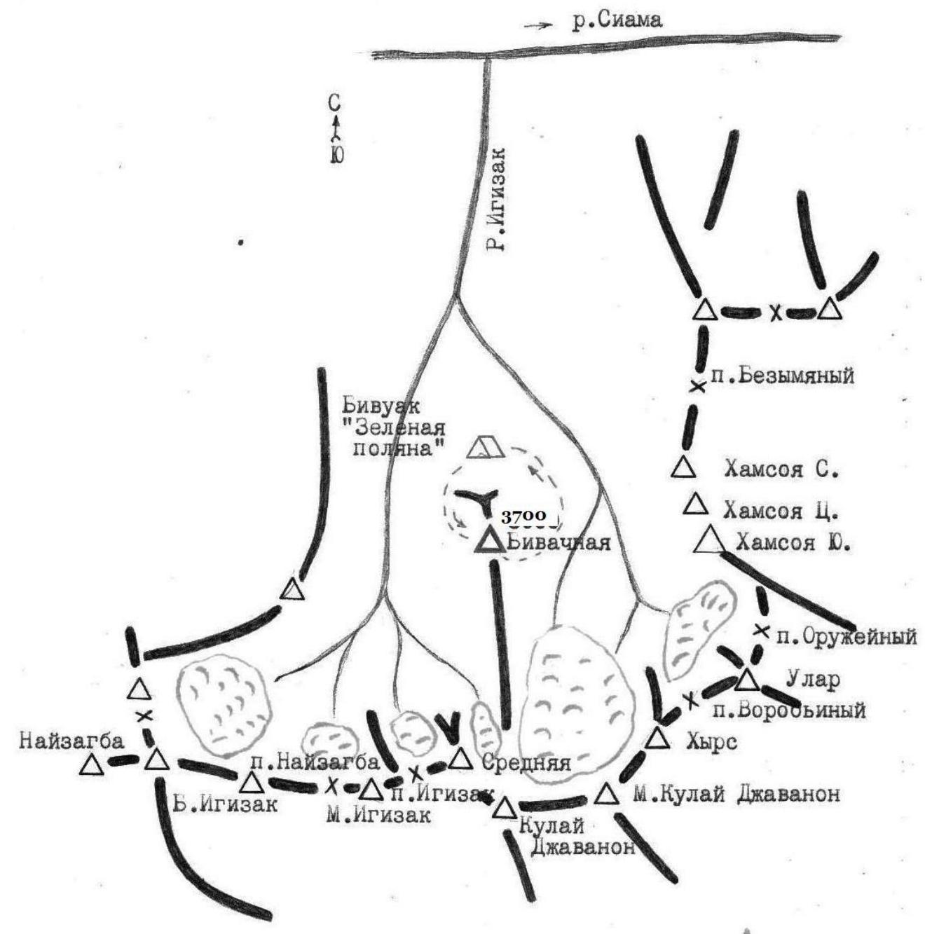
Map of the area (From S. N. Sogrin's book "Routes of Pamir-Alay")
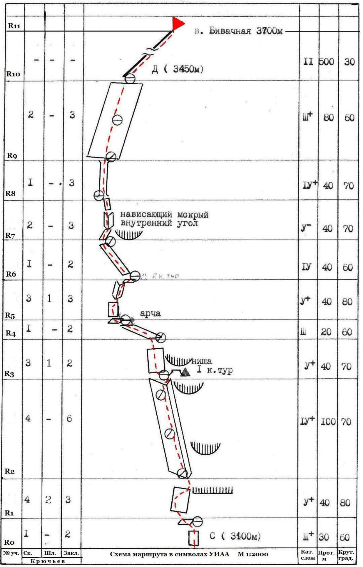
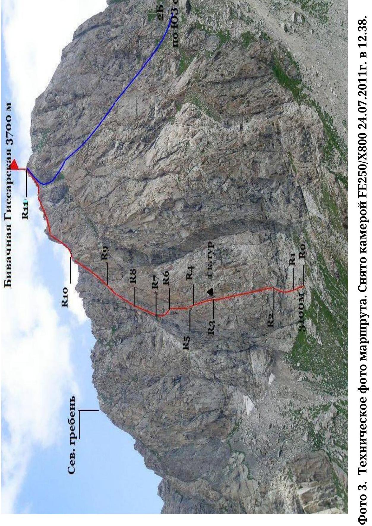
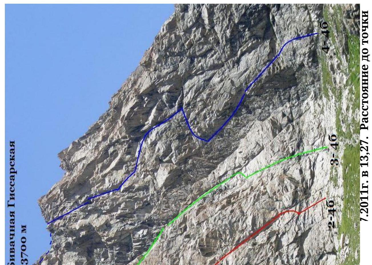
Photo 3. Technical photo of the route. Taken with FE250/X800 camera on July 24, 2011 at 12:38. Distance to the shooting point 1 km.
Route Description
R0–R1 — along smoothed, несложным скалам 30 м on a shelf under a cornice, closing the crevice.
R1–R2 — the cornice is bypassed on the left along a smooth plate in an arc left-up-right. This is the first key section of the route. The cracks are глухие and when climbing (traversing) it is practically impossible to reliably organize intermediate belays. Since in previous years, groups with not very high rock climbing training led to falls and injuries, the author of the route decided to hammer in two bolted hooks. The hooks do not сильно help in passing, but create a более reliable belay.
R2–R3 — the "crevice" of the wall — this is a powerful internal angle with smoothed rocks, passing almost through the entire wall. The route was not climbed for 24 years, so on the rocks:
- a lot of мелкого песка
- пыли
Effective for belays are anchor hooks. After 100 m, a niche with the 1st control tour. The note has decayed.
R3–R5 — from the control tour, 2 path options:
- straight up — a более difficult option (here too, a 2nd bolted hook was hammered in, предположительно from here "улетела" a group of instructors)
- first, a косым traverse to the left 5–7 м, then up to the арче
Арча on a shelf under an отвесной wall. The wall is passed on the left: first along the internal angle (5 м), then traversing to the right under a нависающий internal angle.
R5–R6 — Нависающий destroyed internal angle — a chimney. This is the 2nd key section of the route. Very attentively, the cracks are забиты грязью and пылью. Here too, for the safety of passage, a bolted hook is hammered in. The chimney leads under a smooth рыжую plate.
R6–R7 — Movement diagonally to the left behind the angle of the wall, then traversing under a нависающий wet internal angle.
R7–R9 — a нависающий internal angle, plates with crevices, and an отвесный chimney create excellent sensations for любителей экстремального лазания. After the chimney, a series of internal angles with walls lead to the plates of the northern exposure. R9–R10
- The plates are generally not steep, but with short взлётами of smoothed rocks. A lot of разрушенных rocks. Along the plates, vertically, you can exit directly to the ridge or go to the right to the контрфорс of the Western wall. R10–R11 — the summit seems nearby, but the long and tedious гребень after the wall does not allow relaxation, and if there is no water, it exhausts the last strength. Descent via 1B to the cirque of the Kulay-Djavanon glacier, but if you choose not the optimal path to the right, you can stumble upon several unpleasant rappels.