Ascent passport
- Ascent class - rock
- Ascent area - Igizaki, Gissar ridge
- Peak - Bivachnaya (northern) - 3800 m, via the Western wall through the cave.
- Proposed difficulty category - 5A
- Route characteristics: Elevation difference - 600 m, length of sections 5–6 cat. diff. - 240 m, average steepness of the wall part - 75–80°
- Equipment used: rock pitons for belay - 61 pcs., for artificial climbing holds (ACH) - 16 pcs., chocks for belay - 26 pcs., for ACH - 11 pcs., bolt pitons for belay - 2 pcs., for ACH - 3 pcs.
- Total hours of climbing: approach from "Zelyonaya polyana" bivouac - 1 h, ascent to the summit - 18 h, descent from the summit to "Zelyonaya polyana" bivouac - 1 h 30 min.
- Possible overnight camping sites:
- under the black ledge (1st control cairn) - sitting
- "in the cave" (2nd control cairn) - sitting
- on the ridge
- Ascent accomplished by instructors from "Varzob" alpine camp:
- Igolkin V. I. (Candidate Master of Sports) - leader
- Cherepov V. A. (Master of Sports) - participant
- Osipov V. A. (Candidate Master of Sports) - -"-
- Remenok V. A. (1st sports category) - -"-
- Departure to the route from the bivouac under the Western wall - July 22, 1980. Return to the bivouac after the ascent - July 23, 1980.
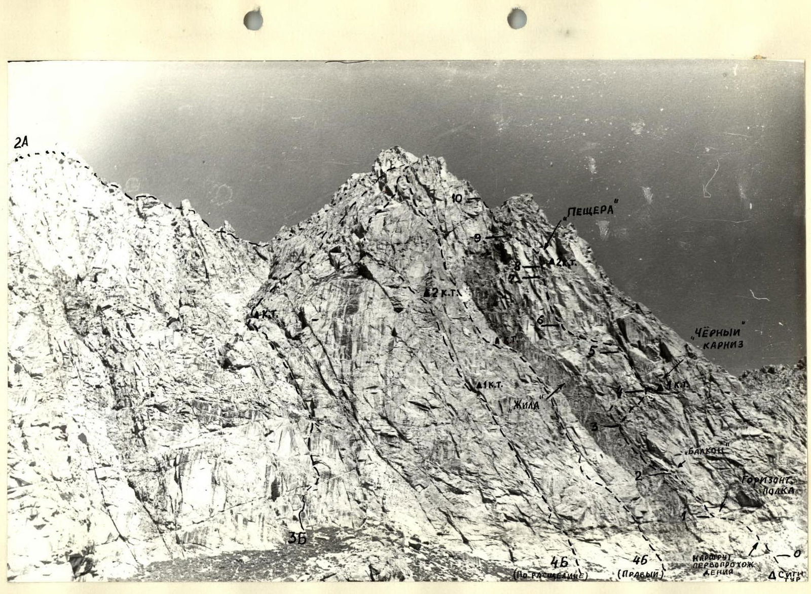
Photo 2. General view of the Western wall of Bivachnaya peak
Table of main characteristics of the ascent route
Clear, windless, temperature +7°.

| Designation | Average steepness in degrees | Length in m | Terrain character | Difficulty | Condition | Rock pitons | Chocks | Protrusions |
|---|---|---|---|---|---|---|---|---|
| R0–R1 | 70 | 40 | Smooth slabs with shelves | III | Slightly destroyed | 5 | 1 | |
| R1–R2 | 75 | 40 | Internal corners, sheer walls | V | same | 5+II | 4 | |
| R2–R3 | 70 | 45 | Shelves with sheer walls | IV | Destroyed | 6 | 3 | |
| R3–R4 | 60 | 35 | Shelves with sheer walls, internal corners | IV | Slightly | 6 | 2 | |
| R4–R5 | 80 | 40 | Internal corners, chimney, smooth slab | V | destroyed | 8+III | 4+III | |
| R4.1 | 80 | 20 | Internal corners | V | Monolithic | /3+I/ | /2+II/ | |
| R4.1–R4.2 | 95 | 7 | Overhanging chimney | VI | -"- | /2+IIA | 1+III/ | |
| R4.2–R5 | 75 | 13 | Cleft, smooth slab | V | -"- | /3/ | /I/ | |
| R5–R6 | 70–90 | 40 | Inclined smooth slabs, sheer slabs, shelves | V | -"- | 6+II I+III | 3 | |
| R5.1 | 70 | 30 | Inclined smooth slabs, shelves | V | -"- | /3/ | /2/ | |
| R5.1–R6 | 85 | 10 | Sheer smooth slab | VI | -"- | /3+II//I+II/ | /I/ | |
| R6–R7 | 85 | 40 | Sheer chimney with internal corners, sheer walls | VI | -"- | 7+V | 2 | 5+III |
| R7–R8 | 65 | 10 | Walls, internal corners | IV | -"- | 4 | 1 | |
| R8–R9 | 80 | 40 | Overhanging wall, ledge, slabs, internal corners | V | -"- | 5+V | 2+IV | |
| R8.1 | 95 | 10 | Overhanging wall | VI | -"- | /2+IV/ | 1+III | |
| R8.1–R9 | 75 | 30 | Sheer walls, shelves | V | -"- | /3+I/ | /1+I/ | |
| R9–R10 | 75 | 40 | -"- | V | -"- | 7+I | 4 | |
| R10–R12 | 45 | 600 | Ridge, couloirs, walls | II | Destroyed Slightly destroyed |
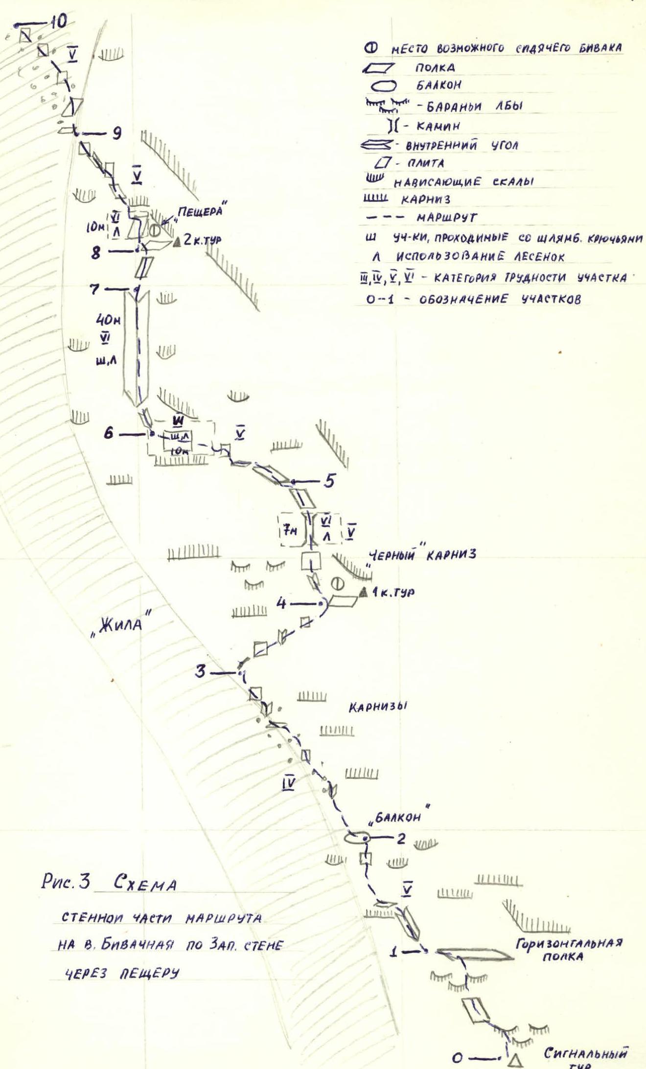
Description of the route to Bivachnaya peak via the Western wall through the cave, 5A difficulty category
General part
From "Zelyonaya polyana" bivouac: Move along moraines and grassy slopes initially towards Maly Igizak peak - 500 m, and then towards Bolshoy Igizak pass along the left scree slopes descending from the ridge of Bivachnaya peak.
Approach to the wall: Approach the Western monolithic wall of Bivachnaya peak, in the central part of which a vein of black rocks runs vertically, resembling an integral sign (see photo №2). From the bivouac to the base of the Western wall - 1–1.5 hours walking.
Start of the route: Begins to the right of the "vein", 30–40 m from the rock-moraine ridge approaching the right part of the Western wall. Here is a signal cairn.
Route passage: Passes between the overhanging right edge of the wall and the "vein" (3rd rope, 40 m along the right edge of the "vein") through a characteristic black ledge in the middle part of the wall (1st control cairn) and a cave in the upper part of the wall (2nd control cairn).
Completion of the route: From the wall section, near the exit of the "vein" onto the upper edge of the wall, the route leads to the Western ridge, which leads to the pre-summit northern ridge of Bivachnaya peak.
Additional information: The position and orientation of the route at a height of 50–60 m from the base of the Western wall are shown in Fig. 2.
Descent from the summit via route 1B cat. diff. The route is logical because it follows the simplest path possible between the "vein" and the overhanging right edge of the wall. The most challenging part is the second half of the route (after the 1st control cairn), especially the exit to and from the cave. There are no other, simpler options for reaching the "cave". The route approaches 5B in difficulty, with sections of 6 cat. diff., so it is recommended for well-prepared sports groups with a strong leader as training for routes 5B and 6 cat. diff.
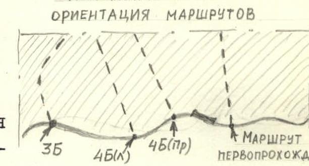
Fig. 2
In the second half of the route, it passes above the start of route 45 (right), there are sections with destroyed rocks, so for safety reasons, it is not recommended to follow these two routes in parallel.
Description of route sections
Section R0–R1. The route begins to the right of the "vein", 30–40 m from the rock-moraine ridge approaching the right part of the Western wall, where a signal cairn is located near the wall. From the signal cairn, ascend via smooth slabs resembling "ram's foreheads", interspersed with small inclined shelves, with piton belay (40 m) to a large shelf. The shelf is under a smooth monolithic wall with ledges 2–3 m above, bounded on the right by a large overhanging wall, and on the left, it drops down with a sheer wall.
Section R1–R2. On the left part of the shelf, ascend via a slightly pronounced cleft with destroyed rocks, bypassing the wall with ledges on the left (7–10 m with artificial climbing holds), upwards-left. Then, traverse 5–7 m left along the shelf on the wall overhanging above the "vein", and subsequently ascend via a series of sheer walls with small inclined shelves, upwards-left towards an arch (20 m) located under a "balcony". The "balcony" is a large rock protrusion, almost cubic in shape, separated from the wall by a crack. Exit onto the balcony via a sheer internal corner with a crack (3–4 m), where a good platform awaits to receive a partner.
Section R2–R3. From the "balcony", move left onto the "vein" and ascend under the ledges along its right edge - 45 m. This is a rock of blocky structure made of black rocks. Attention! The rocks are destroyed.
Section R3–R4. After 45 m, at the transition between the "vein" and the wall (monitor this spot via the rope), there will be a sheer internal corner with a cleft (2–3 m), leading to a shelf and further, beyond the overhang, onto the wall. Here, via shelves with short sheer walls and internal corners, ascending with a traverse to the right, exit onto a shelf with a dry juniper under a black ledge. A tin can is hung on a piton on the ledge (1st control point), visible through binoculars from the stream under the Western wall. A sitting bivouac is possible on the shelf.
Section R4–R5. From the shelf, bypassing the black ledge on the left, begin ascent via a cleft formed by smoothed, rounded rocks resembling "ram's foreheads". It's challenging; from the cleft, it ejects to the left. Artificial climbing holds. The cleft, via a shelf and a sheer wall (20 m), leads to an overhanging chimney, the upper right part of which is a ledge. The chimney (7 m) is traversed with artificial climbing holds on ladders. The chimney leads to a smooth slab bounded on the right by an overhanging wall, with a cleft. Ascend 13 m via the cleft to a sheer wall with a small rusty, triangular protrusion separated by cracks. Above the slab, higher on the left, is a black overhanging wall. Above the rusty triangular protrusion (10–12 m) is a black internal corner, clearly visible from the stream under the Western wall (route landmark).
Section R5–R6. From the rusty protrusion, traverse left 5–7 m via smooth slabs, then ascend via shelves with short walls, traversing left (20–25 m) to a shelf with a small juniper, to the left of which, higher up, is a sheer smooth wall with a small horizontal crack in the middle. The shelf and wall overhang the wall below. The section is psychologically and technically challenging. The smooth wall is traversed via an oblique ascent to the left (5–7 m) with the placement of bolt pitons, on ladders. After the wall, on its ridge, is a poorly defined couloir with a small shelf.
Section R6–R7. From the shelf, a poorly defined couloir leads vertically upwards to the cave, representing a sheer relief wall bounded on the right and left by rock protrusions. This sheer section, from 80 to 90°, begins with a cleft leading left-upwards, with a small green juniper. To the right of the cleft is an overhanging wall; it ejects to the left, very challenging. Further, there are sheer internal corners transitioning into walls. The rocks are smoothed, with all holds rounded and facing downwards. This most challenging section of the route (40 m) - cat. diff. 6B - is traversed with thorough piton belay, artificial climbing holds, on ladders, with bolt pitons (20–22 pcs.). At the top, exit left onto a rock protrusion overhanging the wall. Here, belay can be organized, and a rope fixed.
Section R7–R8. From the rock protrusion, exit 10 m into the cave via large protrusions and overhanging corners. The cave is a powerful internal corner with a sheer left wall, an overhanging right-upper wall, and a steep platform facing down into the valley. On the right overhanging wall, a tin can is hung on a bolt piton - 2nd control point. Below, on an inclined slab, is a sitting bivouac.
Section R8–R9. From the cave, via an overhanging internal corner formed by the left and right walls of the cave, ascend via ladders (10 m) to a ledge located above the cave. The ledge is bypassed on the left. Further, left-upwards via sheer internal corners and walls (30 m), exit onto a shelf located on the black "vein". The last 10–15 m feature destroyed rocks.
Section R9–R10. Here, the route passes via rocks of black rock constituting the "vein". From the shelf on a smooth slab, move right-upwards (10 m), then via internal corners transitioning into walls, ascend left-upwards onto a shelf (15–17 m). From the shelf, via a sheer wall on its left part, ascend (7–10 m) to the start of a gentle couloir formed by two halves of the Western ridge.
Section R10–R11. Initially via the couloir, then along the Western ridge with simultaneous belay through protrusions (500 m), exit onto the pre-summit Northern ridge.
Section R11–R12. Leads through 100 m of simple monolithic rocks to the summit.
Descent from Bivachnaya summit to the southeast via route 1B cat. diff. From "Zelyonaya polyana" bivouac, the route is completed in 20–24 hours.
Place for a possible sitting bivouac.