№ 539 "32" dated 24.04.84 4Б cat. diff./n
Ascent Passport
- Type of ascent — rock climbing
- Ascent area — Sang-Hok, Hissar Range
- Peak, height, ascent route — XXX лет «Варзобу», 4367 m, via the central ridge from the northeast.
- Category of difficulty — 4Б (proposed)
- Route characteristics: Height difference — 250 m, Average steepness — 65°, Length of sections with 5th cat. diff. — 95 m
- Pitons hammered for belay: Rock and chock elements — 25, Ice screws — 3.
- Number of walking hours: Approach — 3 h 30 min, Ascent to the summit — 6 h, Descent and return — 3 h 30 min. Total: 13 h.
- No overnight stays on the route.
- Surname, name, patronymic of the leader, participants, their qualification: Vorobyova Nelina Nikolaevna — CMS, leader; Afanasiev Andrei Evgenievich — CMS; Gusev Dmitrii Petrovich — CMS; Seryogin Arkadii Borisovich — 2nd sports category.
- Team coach — Vorobyova N.N., instructor-methodologist of the 1st category.
- Date of departure and return — July 8, 1983.
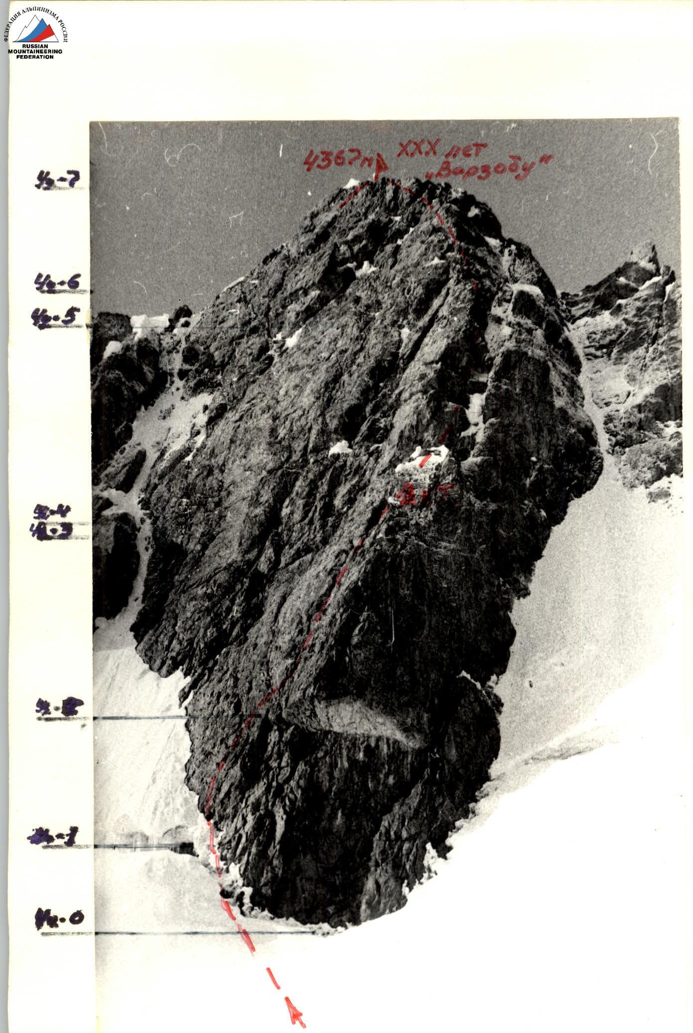 Route diagram in UIAA symbols for v. XXX лет «Варзобу» via the central ridge from the northeast. First ascent of proposed 4Б cat. diff.
 Table of main characteristics of the ascent route to v. 4300 m, conditional name «30 лет Варзобу» via the central ridge from the northeast, 4Б cat. diff. p/p.
| Date | Designation | Average steepness | Length, m | Terrain character | Difficulty | Condition | Weather conditions | Rock pitons | Ice pitons |
|---|---|---|---|---|---|---|---|---|---|
| 08.07.83 | О–1 | 45° | 40 | snow-ice slope | 3 | randkluft | good | simultaneous movement | |
| departure at 6:00 | 1–2 | 50° | 40 | ice slope | 4 | avalanche danger | " | 2 | 3, crampons |
| return at 18:00 | 2–3 (control cairn) | 55° | 20 (scree shelf) 20 (chimney) | scree shelf, chimney | 3, 4 | destroyed, iced | " | 5 | |
| 3–4 | 70° | 7 | crack | 5 | monolithic | " | 3 | ||
| 4–5 | 70° | 70 | chimney | 5 | iced, rockfall danger | " | 8 | ||
| 5–6 | 65° | 40 | wall | 5, 4 | iced | " | 4 | ||
| 6–7 | 60° | 15 (wall) 25 (ledges) | wall, ledges | 5, 3 | monolithic, destroyed | " | 3 |
Brief description
of the approach and route via the central ridge from the northeast to the summit XXX лет «Варзобу» 4367 m, 4 cat. diff. (approximately).
From the base camp located in the upper reaches of the Sang-Hok valley on a grassy clearing under the slopes of the «40 лет Комсомола Таджикистана» massif, first along grassy and then snowy slopes, ascend to the Sang-Hok pass, 3900 m.
From the pass — with a loss of height:
- bypass the rocky slopes of Nosorog peak along the snow (left — icefalls);
- exit to the right side of the glacier located in the cirque of peaks XXX лет «Варзобу» and p. Треугольный.
Crossing the glacier in the direction of the central ridge of v. XXX лет «Варзобу» — approach the route.
Approach to the route — 3 h 30 min.
The glacier is closed, with crevasses observed away from the movement.
The peak XXX лет «Варзобу» is one of the highest in the area.
The peak and route of the proposed 4Б cat. diff. are clearly visible from:
- the base camp,
- the dead end of the road near the "Narzan" spring.
The central (northeast) ridge leads to the summit. To the left and right of it — ice couloirs (the right one is steeper, up to 65°). At the lower part of the ridge — a large light-gray cornice.
Section О–1. Bypassing the cornice along the snow-ice slope, hugging the rocks, with an exit to the left bergschrund, 40 m, 45°. The bergschrund is of significant depth, partially filled with snow, which avalanches down the slope. Near the ridge, the bergschrund turns into a randkluft. Good belay spot.
Section 1–2. The randkluft is crossed in crampons with an exit to the ice slope with belay:
- through ice screws
- at the end of the rope — through rock pitons
40 m, 60°. Good belay spot on an inclined scree shelf, moving to the rocks. Crampons are not needed further on the ascent.
Section 2–3. Along an inclined steep scree shelf (like a chute) exit to a chimney filled with ice. Above the chimney — an overhang, which is bypassed by traversing left to the wall. On the right side at the end of the chimney — a control cairn. Belay spot is convenient only for 1 participant.
Total length: 40 m, including:
- chimney — 20 m
- traverse — 5 m of difficult climbing.
Sections R3–R4 and R4–R5. Having passed 7 m through a crack 70°, 5 cat. diff., we reach the base of a wide chimney filled with ice 70 m, 70°, 5 cat. diff. At the top, move to the left side of the chimney. At the end of the first rope, the belay spot is hanging, on the right wall of the chimney. Ice fragments fall down the chimney. At the end of the chimney, traverse left 5 m and a convenient belay spot.
Section R5–R6. Along the wall 65°, climbing is difficult on iced rocks, bypassing a small overhang, 20 m — 5 cat. diff., 20 m — 4 cat. diff. Belay spot on a small shelf with good cracks for pitons, convenient.
Section R6–R7. Along the wall 15 m, 4 cat. diff. and further along simple rocks to the summit. Belay at the end of the rope is possible through:
- ledges
- a bend 3 cat. diff. At the beginning of the rope, climbing is difficult — 5 cat. diff.
Descent from the summit to the east along destroyed rocks 2–3 cat. diff., 100 m to a snow-ice couloir leading to the glacier, which descends into the Lailak-Kul valley.
The glacier is closed with many crevasses. Direction of movement:
- to the Sang-Hok pass
- further descent to the base camp
Descent from the summit and return to the camp took 3 h 30 min.
The route is characterized by logic. The route is combined. In good weather, the rocky sections of the route can be climbed in galoshes. The route requires:
- crampons (at least 2 pairs per group)
- ice screws
- rock pitons
Ice axes are desirable. The route is recommended for camp and sports groups.