Треугольный (4100) via W rib - 4A cat.
 350, 45–50°, 30 m, 1, 20 pitches, 6 hours. Yu. Emelyanenko, T. Medvedeva 28/VII-83.
Average steepness of sections R2–R10: 50–55°. Average steepness of sections R10–R20: 45°.
Table of main characteristics of the ascent route to peak 4100 m (conditionally named peak Треугольный) via Western rib 4A cat.
- Summit elevation: 4100 m
- Conditional name: peak Треугольный
- Difficulty category: 4A
- Ascent direction: via Western rib
- Route type: ascent
- Terrain characteristics: rocky section with moderate slope
- Predominant rocks: possibly metamorphic or magmatic
- Passage season: summer period
- Ascent duration: 1–2 days
- Approach to the start of the route: on foot, through a valley or pass
- Equipment: standard mountaineering gear
- Hazards: rockfall, icy sections, variable weather
- Visibility: good in clear weather
- Descent: via the same route or an alternative path
| Date | Designation | Average steepness | Length in m | Terrain character | Difficulty | Condition | Weather conditions | Rock pitches | Ice pitches |
|---|---|---|---|---|---|---|---|---|---|
| 28 July 1983 | R0–R1 | 30° | 120 | snow | 1 | snow | good | simultaneous movement | |
| Departure at 6:30 | R1–R2 | 35° | 20 | rocky | 1–2 | rocks with loose stones | —"— | ||
| R2–R3 | 65–70° | 55 | inner corner | 3–4 | destroyed rocks | —"— | 2 | ||
| Return at 14:30 | (control cairn 1) | ||||||||
| R3–R4 | 15° | 5 | ledge | 1 | monolith | —"— | — | — | |
| R4–R5 | 85° | 30 | chimney | 5 | —"— | —"— | 6 | — | |
| R5–R6 | 45° | 40 | ledges | 3 | destroyed rocks | —"— | — | — | |
| R6–R7 | 70° | 20 | wall | 3+ | —"— | —"— | 2 | — | |
| R7–R8 | 30° | 40 | ledge | 2–3 | —"— | —"— | — | — | |
| R8–R9 | 70° | 4 | inner corner | 4+ | —"— | —"— | — | — | |
| R9–R10 | 40° | 30 | ledge | 2–3 | —"— | —"— | — | — | |
| (control cairn 2) | |||||||||
| R10–R11 | 45° | 15 | rocky ridge | 2 | —"— | —"— | — | — | |
| R11–R12 | 85° | 10 | chimney | 4 | —"— | —"— | 4 | — | |
| R12–R13 | 50° | 10 | rocky ridge | 4 | monolith | —"— | — | — | |
| R13–R14 | 90° | 5 | wall | 4 | destroyed rocks | —"— | 2 | — | |
| R14–R15 | 55° | 20 | inner corner | 4 | —"— | —"— | — | — | |
| R15–R16 | 50° | 15 | ledges | 3 | —"— | —"— | — | — | |
| R16–R17 | 60° | 40 | destroyed rocks | 2–3 | —"— | —"— | 2 | — | |
| R17–R18 | 50° | 15 | ledge | 3 | monolith | —"— | — | — | |
| R18–R19 | 80° | 7 | wall | 4 | —"— | —"— | 2 | — | |
| R19–R20 | 50–60° | 100 | rocky ridge | 2–3 | —"— | —"— | — | — | |
 | |||||||||
 |
Brief description of the approach and route along the rib of peak Безымянная (peak Треугольный), proposed 4A cat.
- Approach to the start of the route: on foot through a valley or pass.
- Start of ascent: at the base of the Western rib.
- Route character: movement along the ridge with overcoming rocky sections.
- Technical difficulty: corresponds to 4A cat.
- Main difficulties: narrow sections of the rib, possible rockfall, icy surfaces.
- Equipment: full set of mountaineering gear required.
- Recommended season: summer.
- Duration: 1–2 days.
- Descent: possible via the initial route or through adjacent gullies.
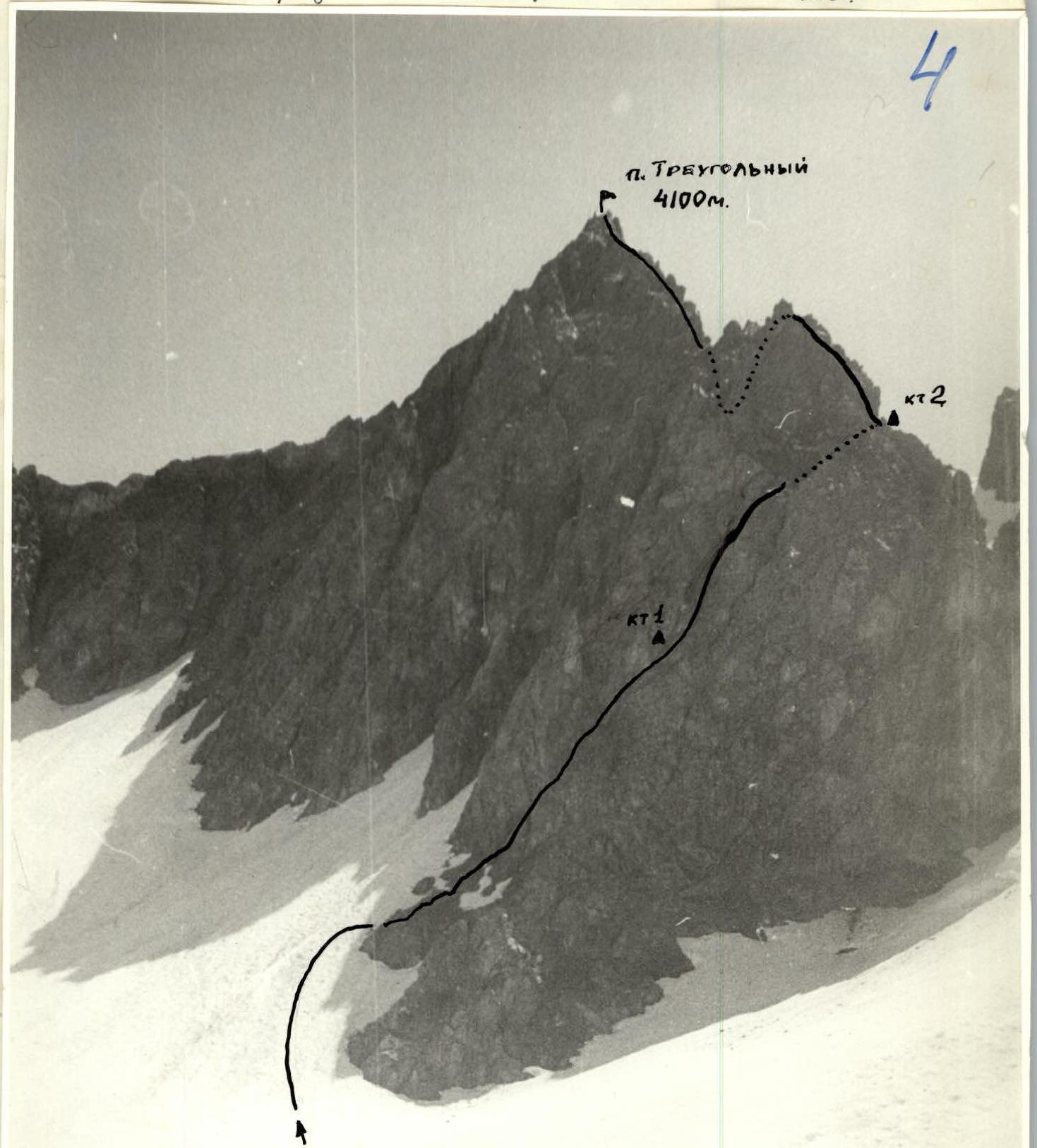
From the base camp located in the upper reaches of the Hodja-Sanghok gorge on a grassy clearing under the slopes of peak 40 лет Комсомола Таджикистана (northeast) and Sanghok pass (east), first along grassy, then snowy slopes, ascend to the cirque glacier between the slopes of peak 30 лет Варзобу and peak Корона Сангхока under the slopes of peak Треугольный.
Approach to the route - 1–1.5 hours. Peak Треугольный is located in the ridge between peak 30 лет Варзобу and peak Носорог. The peak and the proposed 4A cat. route are clearly visible from the base camp, as well as from the roadblock near the "Нарзан" spring.
The route starts with an approach on snow to a rocky ledge located to the left of the lower rocky outcrop.
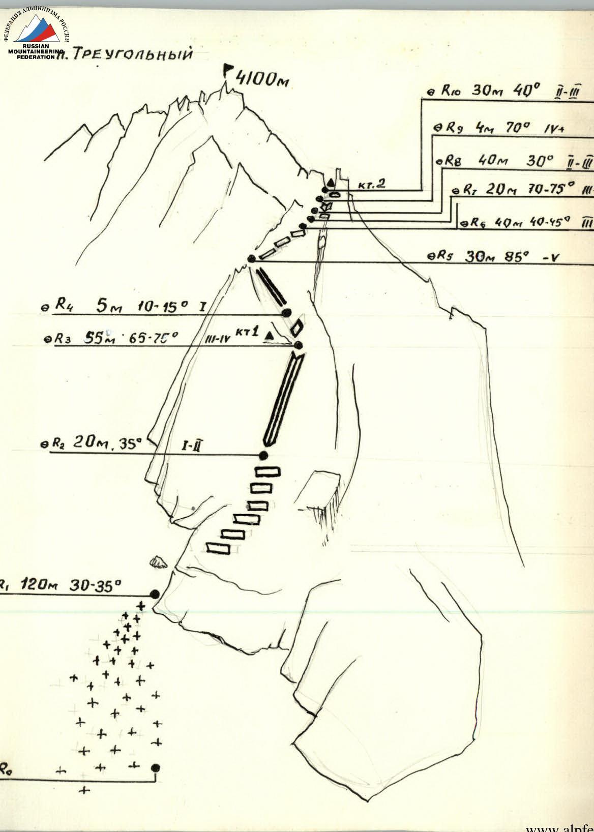
R0–R1. Ascend to the rocky ledge via a snowy slope 120 m, 30–35°. Then - exit onto rocks.
Section R1–R2. Approach to the right along easy rocks to the base of an inner corner. Simultaneous movement along rocky ledges. Loose stones! 20 m, 35°.
Section R2–R3. Ascend the steep rocks of the inner corner with alternate belay. Belay through outcrops, 2-3 rock pitons. 55 m, 65–70°. The inner corner leads to a ledge under a triangular light-colored wall, where the first control cairn is set. Rocks 3-4 cat. Time from the start of the route - 1 hour.
Section R3–R4. Move right along the ledge 5 m, 10–15°.
Section R4–R5. Left up the inner corner 30 m, 85°. Climbing is complex. At the top - exit onto a counterfort via the right wall of the inner corner, turning into a chimney. Piton belay!
Section R5–R6. Bypass a sentinel to the left along ledges and rocks of medium difficulty 40 m, 40–45°.
Section R7–R8. Wall 70–75°, 20 m. Rocks of medium difficulty.
Section R8–R9–R10. Exit onto the ridge via:
- an inclined ledge under black slabs with red lichen, 40 m;
- inner corner 70°, 4 m;
- steep scree ledge, 30 m.
On the ridge under a sentinel, a 2nd control cairn is set. Time from the start of the route is about 3 hours.
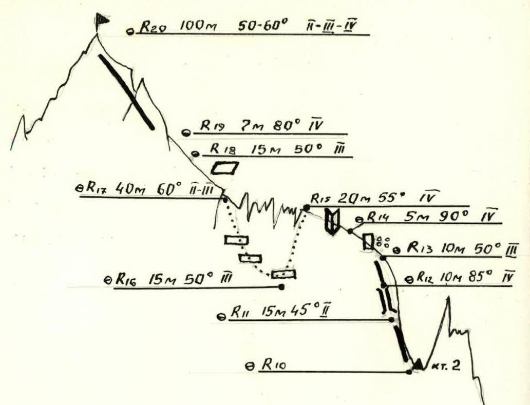
Section R10–R11. Further movement along the ridge. Rocks of medium difficulty 15 m, 45°. Loose stones!
Section R11–R12–R13–R14. Chimney 10 m, 85°; then 10 m along rocks of medium difficulty and exit to the start of an inner corner via steep rocks: a dissected wall 5 m, 85°. Loose stones!
Section R14–R15. Ascend the inner corner 20 m, 55°. Piton belay! Exit onto a saddle (lowering in the ridge) with sharp sentinels, to bypass which descend from the ridge to the right.
Section R15–R16–R17. Descend to the right for 15 m along scree ledges and ascend along severely destroyed rocks 20 m, 55°. Piton belay!
Section R17–R18–R19. After exiting onto the ridge, move right along a wide inclined slab 15 m, 50°; then left up a wall 7 m, 80°.
Section R19–R20. Further along the ridge - exit onto the summit. Rocks of medium difficulty with short steep sections 100 m, 50–60°.
The route is logical. The ascent to the summit took 6 hours. The route is rocky. On the route, the following are necessary:
- rock pitons - 10-15 pieces;
- hammers.
Difficult rock sections can be traversed in galoshes. The route is recommended for camping and sports groups.
Descent from the summit along the ridge to the saddle with peak Носорог. Then left down snowy and scree slopes to grass. The descent from the summit took 2 hours.
Total time - 8 hours.


