№ 539 № 33 0524.04.84 BAC p/v ASCENT PASSPORT
I. Ascent class — rock
-
Ascent area — Sang-Hok, Gissar Range
-
Summit, height, ascent route — Korona Sang-Hoka, 4250 m, via the north-eastern wall.
-
Complexity category — 5A
-
Route characteristics:
Height difference — 700 m. Average steepness — 65°. Length of complex sections — 360 m.
-
Pitons driven: for belaying, for AID rock — 27 ice — 18 bolts — passive protection — 26
-
Number of climbing hours — 12 h
-
Number of bivouacs, their characteristics:
There were no bivouacs on the route.
- Surname, name, patronymic of the leader, participants, their qualification:
| Khafizov A. F. | CMS | leader |
|---|---|---|
| Khairulin R. Sh. | CMS | |
| Holobtsev A. V. | CMS | |
| Poroikov V. I. | CMS | |
| Eremin O. Yu. | CMS |
- Date of departure and return — June 29, 1983

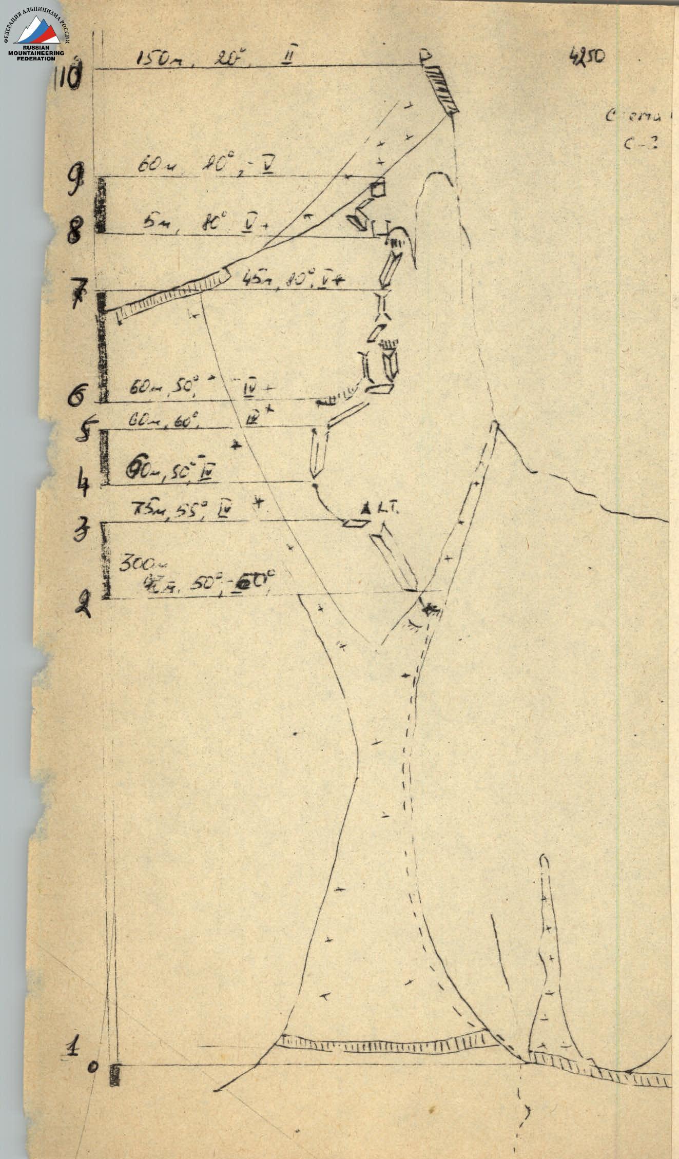
TABLE OF MAIN ROUTE CHARACTERISTICS
to the summit of Korona Sang-Hoka via the north-eastern wall 5A cat. (orientation)
| Date | Designation | Average steepness | Length, m | Relief characteristics | Difficulty | Condition | Conditions | Rock pitons | Passive protection | Ice pitons | Bolt pitons |
|---|---|---|---|---|---|---|---|---|---|---|---|
| June 29, 1983 | R0–R2 | 40–60° | 350 | ice-snow slope | good | good | — | — | 16 | — | |
| R2–R3 | 55° | 75 | dihedral | IV | — | many loose rocks | 5 | 4 | — | — | |
| R3–R4 | 50° | 60 | rocky ridge | IV+ | solid | — | 4 | 3 | — | — | |
| R4–R5 | 60° | 60 | dihedral | V | — | small holds | 6 | 3 | — | — | |
| R5–R6 | 50° | 60 | ledge and crack | IV+ | monolithic | — | 4 | 5 | — | — | |
| R6–R7 | 80° | 45 | chimney or dihedral | V+ | monolithic, smooth | — | 3 | 4 | — | — | |
| R7–R8 | 80° | 5 | wall | V+ | — | — | 1 | 4 | — | — | |
| R8–R9 | 80° | 60 | wall, dihedral | V | — | — | — | 7 | — | — | |
| R9–R10 | 20–30° | 150 | snow-ice ridge | II | wet | — | — | — | 2 | — | |
| TOTAL | 27 | 26 | 18 | — |
Brief explanation of the table of main route characteristics
0–20 m from the bergschrund, which is overcome depending on the condition, via a bridge or via rocks on the right. Exit to a snow-ice slope with a steepness of 50–60°, moving in crampons, with piton belays, length — 300 m. Movement goes close to the left part of the rocky "paws" of the bastion. General direction in the last third — into the couloir between the pre-summit ascent and the bastion.
After entering the couloir, transition through rocky outcrops and entry into the R2–R3 dihedral with a steepness of 55°. The dihedral consists of alternating smooth areas and good holds. At the top of the dihedral, there is a ledge with loose rocks.
R3–R4: Along a vaguely expressed ridge, 60 m transition to the left under the base of a clearly visible dihedral.
R4–R5: 60 m along the dihedral with small holds to a sloping ledge. A cornice overhangs from above.
R5–R6: Along the ledge (under the cornice), transitioning into a steep crack, 60 m, difficult climbing.
R6–R7: 45 m of difficult climbing. Possible variations: via a chimney or a smooth dihedral to a sloping ledge.
R7–R8: From the ledge, 5 m up the wall and chimney — exit into the gap of a spall.
R8–R9: From the spall, 5 m wall, smooth, traverse through a "bump" with a small ledge to the left, 15 m, entry into a dihedral with a right vertical wall, 35 m along a small, steep crack to a 5 m wall with small holds and onto the ridge ascent.
R9–R10: Along the snow-ice ridge, 150 m to the summit.
Descent in the direction of the couloir under the western wall of p. "30-letiya Varzoba" and along the western wall to the glacier, where the route began.