№ 539 and 34 dated 24.04.84 Order number
ASCENT DOCUMENT
- Ascent class — rock
- Ascent area — Sang-Hok, Gissar Ridge
- Peak, height, ascent route — Korona Sang-Hoka, 4250 m, from the west via the saddle.
- Difficulty category — 3A (first ascenders suggested 4A)
- Route characteristics: Height difference — 700 m. Average steepness — 45°
- Protection devices used: Rock anchors — 14 Ice anchors — 3 Chocks — 3
- Total climbing time — 9 hours
- Number of bivouacs and their characteristics: No bivouacs on the route.
- Surname, initials of the leader and team members, their qualification: Trifonov Yu.S. — 2nd sports category, leader Almukhametov E.A. — 2nd sports category
- Date of departure and return — July 18, 1983
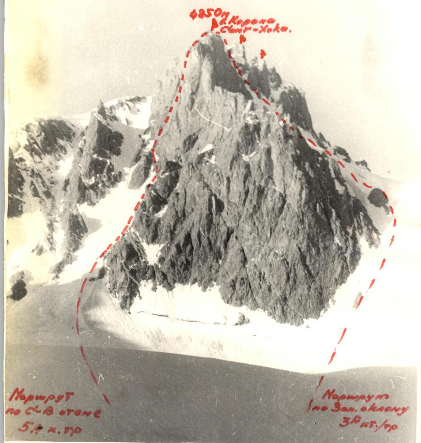
TABLE OF MAIN CHARACTERISTICS OF THE ROUTE to Korona Sang-Hoka peak from the west via the saddle, 3A category of difficulty.
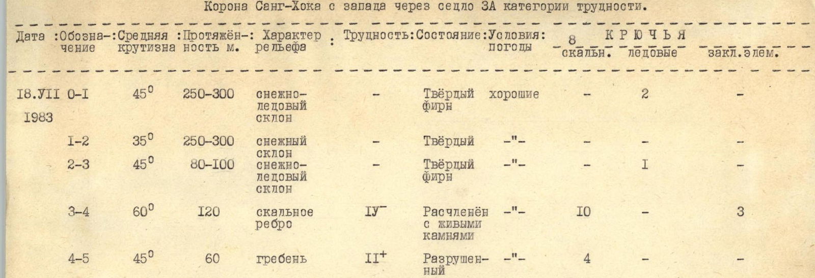
| Date | Section | Average steepness | Length, m | Terrain characteristics | Difficulty | Condition | Weather conditions | Rock anchors | Ice anchors | Chocks |
|---|---|---|---|---|---|---|---|---|---|---|
| 18.07.1983 | 0–1 | 45° | 250–300 | Snow-ice slope | — | Firm, good névé | — | — | 2 | — |
| 1–2 | 35° | 250–300 | Snow slope | — | Firm | — | — | — | — | |
| 2–3 | 45° | 80–100 | Snow-ice slope | — | Firm, névé | — | — | 1 | — | |
| 3–4 | 60° | 120 | Rock ridge | IV | Dissected with loose rocks | — | 10 | — | 3 | |
| 4–5 | 45° | 60 | Ridge | II+ | Destroyed | — | 4 | — | — |
There were no bivouacs on the route. The ascent from the base camp to the summit took 8 hours. Descent — 3.5 hours.
BRIEF DESCRIPTION
Approach and route to Korona Sang-Hoka peak, 4250 m, from the west via the saddle, 3A category of difficulty.
From the base camp located under the slopes of the 40 let Komsomola Tadzhikistana massif, move first across grassy slopes and moraines and then along the glacier towards the clearly visible saddle in the western ridge of Korona Sang-Hoka. From the base camp — 1–1.5 hours.
Climb the snow-ice slope towards the rock outcrop on the saddle. In the second half of summer, crampons are necessary for the ascent. Protection via ice axe and ice anchors. When reaching the saddle, the slope steepness reaches 50–55°.
From the rock outcrop on the western snow slope, move towards the rock ridge between the first and second teeth of Korona. With good snow conditions, simultaneous movement is possible.
Before the ridge, the slope becomes steeper, with ice outcrops. To the right and left of the ridge on the main summit ridge, there are hanging cornices. On this section, move under the protection of the ridge along a subtle snow ridge, avoiding the couloirs.
The ascent to the ridge begins with a steep rock wall. Climbing is complex, IV–IV+, 20 m. Protection is via rock anchors. Further movement is along the outer part of the ridge through a system of cracks, internal angles, ledges, and walls with anchor protection to the col between the teeth of Korona. Do not go under the cornices!
From the col, turn left and along the ridge from the southeast, reach the summit. Protection via rock formations and anchors.
Descent from the summit via the ascent route takes 3–4 hours. The route is logical, combined, featuring diverse technical work, and contributes to the development of tactical literacy among climbers. Recommended for expedition and sports groups. The entire route is clearly visible from the base camp.