1982 USSR Alpine Championship Technical Climbing Category
Report
ON THE FIRST ASCENT OF THE 5250 M PEAK VIA THE EAST FACE BY THE "ALAY" ALPLAGER TEAM
Leader Coach Kavunenko V.D. Kavunenko V.D.
Moscow 1982
For inquiries related to this report, please contact:
- Moscow, ul. V. Krasnoselskaya, 38/19
- MGS DSO "Spartak", Kavunenko V.D.
- Tel. 264–10–47
All elevations, except for the summit height on the title page, were determined using an altimeter. The altimeter reading at the summit was 5150 m. The claimed summit elevation is 5250 m according to geological data.
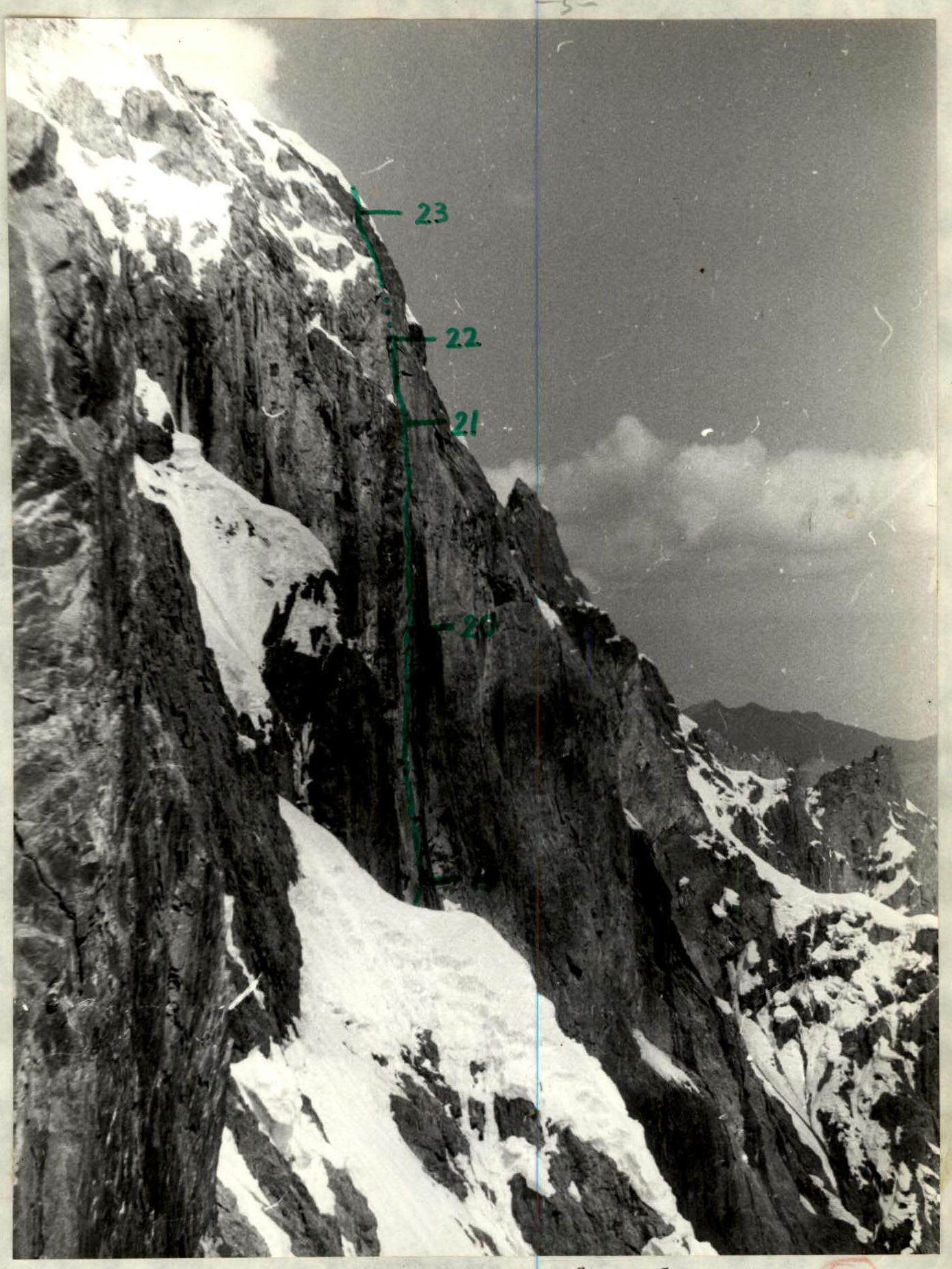
Photo of the upper third of the route profile from the left. Due to the highly concave nature of the wall below 4500 m, it was impossible to capture the profile. The concave nature of the wall is evident in the overall photo and photo #5. Taken on July 20, 1982, around 14:00, using a "Smena" lens, focal length 35, from point #2, at an elevation of about 4700 m, distance approximately 0.8 km.
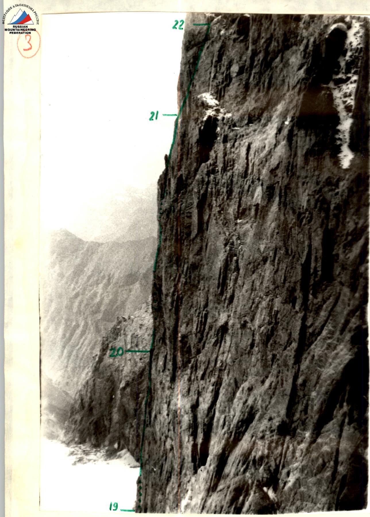
Photo of the upper part of the wall profile from the right. Taken on July 19, 1982, around 15:00, using a "Smena" lens, focal length 35, from point #3, at an elevation of about 4900 m, distance approximately 150 m.
Tactical Actions of the Team
The tactical plan included:
- Day one: reaching a small ledge at approximately 4000 m.
- Day two: advancing to a large cornice near the red rocks.
- Day three: reaching the left snow patch.
- Day four: reaching the central snow patch, processing the bastion.
- Day five: continuing to process the bastion (overnight stay at the same location).
- Day six: traversing the processed section and continuing to the pre-summit rocks for an overnight stay.
- Day seven: reaching the summit (overnight stay at the summit).
The ascent validated the initial assumptions of the tactical plan. The team's movement and bivouac locations aligned with the plan, with one exception: there was only one overnight stay at the central snow patch instead of two. This deviation was due to the plan being based on anticipated regular bad weather in the afternoons. However, by the time the team reached the upper bastions, the weather and route conditions had significantly improved, allowing for more efficient use of daylight.
The rope teams were formed based on their long-term compatibility and remained unchanged throughout the route. To facilitate more coordinated actions among the teams (due to significant distances between the first and last climbers and the lack of a common gathering point), the team was divided into two subgroups of four, each with its own radio and a coordinator who received instructions from the leader.
In accordance with the tactical plan, each rope team led on a pre-assigned section based on their specialization.
- Sections R0–R1, R23–R24, R24–R25, R25–R26: Yermakov
- Sections R1–R2, R2–R3, R3–R4: Khankevich
- Sections R4–R5, R5–R6: Bashkirov and Babitsky
- Sections R6–R7, R7–R8, R8–R9: Kavunenko
- Sections R9–R10, R10–R11, R11–R12, R12–R13: Zybin
- Sections R13–R14, R14–R15, R15–R16: Ibragim-Zade
- Sections R16–R17, R19–R20, R20–R21: Bashkirov
- Sections R17–R18, R18–R19, R21–R22: Babitsky
- Sections R22–R23: Khankevich
This distribution prevented excessive overload on the lead climbers and allowed the team to navigate the complex upper section in good style.
The team pre-processed sections from their bivouacs. The entire route was equipped with fixed ropes for subsequent teams, significantly speeding up the ascent and ensuring safety.
The tactical plan made full use of daylight. Participants rested during periods of waiting out rockfall. All overnight stays were at pre-designated locations, protected by cornices with a duplicated safety system.
There were no falls or injuries.
As anticipated, the challenging sections were R4–R5 and R16–R17 through R20–R21. Section R4–R5 was completed after the thin ice crust on the rocks had melted and water began flowing down the wall. Despite the wet conditions, galoshes enabled the use of friction, and the section was mostly traversed via free climbing.
The second challenging section (R16–R17 to R20–R21) was also traversed with minimal artificial aid and at a very fast pace because:
- The previous day's reduced distance between bivouacs allowed for more time to process the next day's section;
- Bashkirov was less loaded in the preceding days, allowing him to approach his leading sections in excellent form.
The improved weather conditions enabled the team to eliminate one overnight stay at the central snow patch.
The team utilized the latest developments in domestic and foreign mountaineering: chocks, shock absorbers, lightweight autoclaves of new design, hammocks, etc.
The team operated according to the tactical plan even in bad weather, with each participant equipped with a set of waterproof, warm clothing.
The team maintained contact with the observation group (three times a day), who were also required to check in hourly. Radio communication within the group was facilitated by a conditional voice signal.
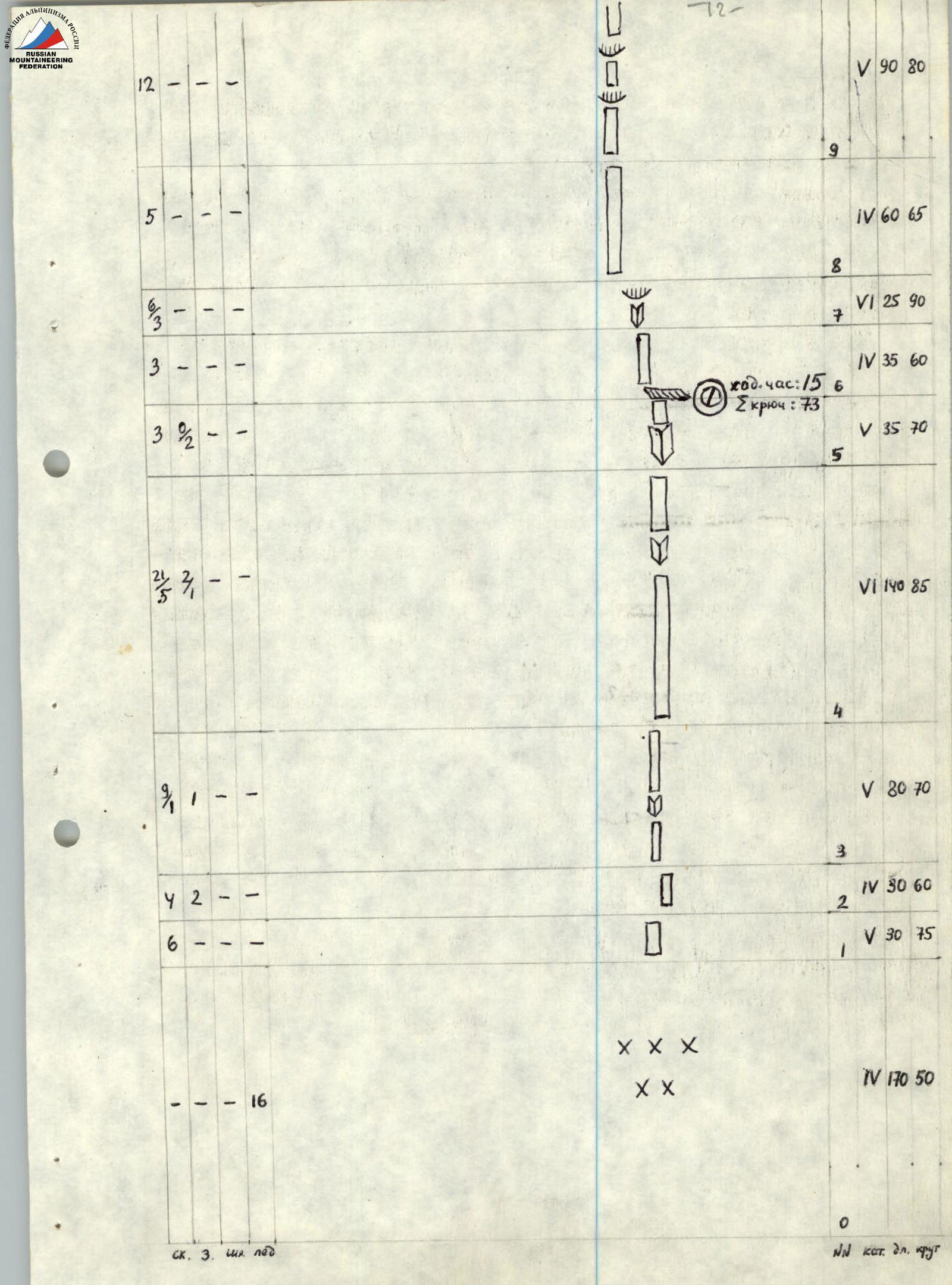
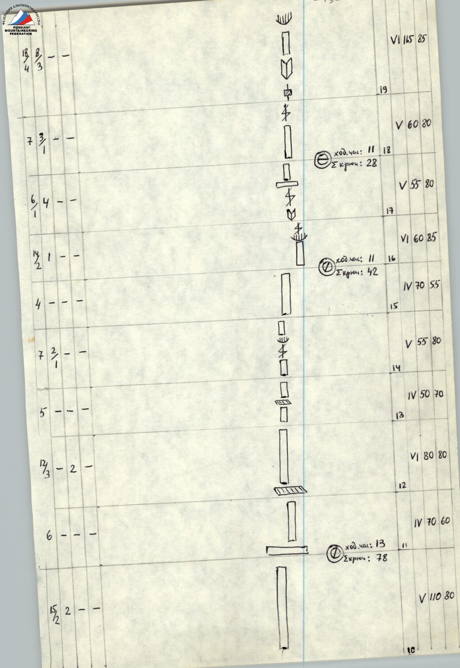
 Total: 72 climbing hours, 342 pitons.
Photo #2. Section R4–R5. The lead climber is circled. Taken with a "Smena" camera, focal length 35 (same for the remaining photos) from the start of section R4–R5.
Photo #2. Section R4–R5. The lead climber is circled. Taken with a "Smena" camera, focal length 35 (same for the remaining photos) from the start of section R4–R5.
Photo 7. Section R16–R17. Icicles on the cornice to the right indicate the vertical direction.
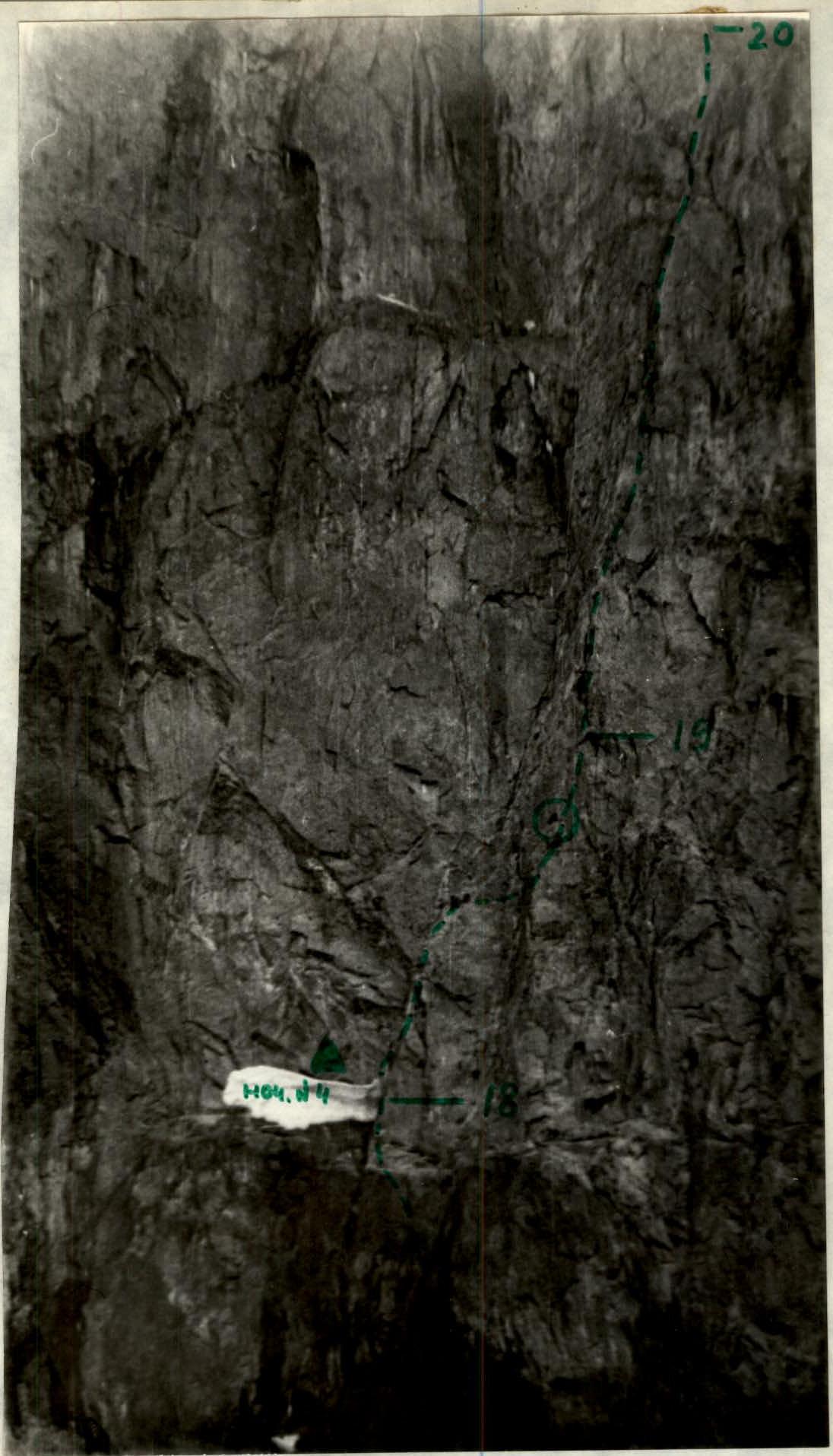
Photo 8. The icicle near the participant's right foot indicates the vertical direction.
Photo 9. Taken with a telephoto lens from the observers' camp. The participant is circled.