
PASSPORT
- High-altitude technical class
- Pamir-Alay, Archabashi gorge
- Tamdykul peak, 5539 m, via the left part of the NW wall
- Proposed 6B category of difficulty, first ascent
- Route elevation gain — 1490 m, wall elevation gain — 1180 m.
Route length — 2180 m, wall length — 1580 m. Length of sections with 5–6B category of difficulty — 1270 m. Average steepness of the main part of the route — 71° (4150–5330 m), of which 6B category of difficulty — 79° (4900–5330 m).
-
Number of pitons used: rock: 116, wedges: 98, channels: 10, chocks: 69, ice screws: 3.
-
Team's climbing hours — 60, and days — 9, including 1 day for preparation, 2 days waiting out bad weather, and 1 day for descent.
-
Overnight stays — all built from stones, in a semi-sitting, semi-reclining position.
-
Team leader — Putinchev Alexander Vladimirovich, Master of Sports Team members:
- Ankudinov Valery Nikolaevich, Candidate Master of Sports
- Gayzulin Gayzula Samigulovich, Candidate Master of Sports
- Goffardt Friedrich Piusovich, Candidate Master of Sports
- Gromov Leonid Valentinovich, Master of Sports
- Radzhapov Rustam Temirovich, Candidate Master of Sports
- Filatov Sergey Alekseevich, Candidate Master of Sports
- Tsoy Vladimir, Master of Sports
-
Coach — Elchibekov Vadim Ashotovich, Master of Sports, Honored Coach of the Uzbek SSR
-
Approach to the route — August 10, 1985. Summit — August 17, 1985. Return — August 18, 1985.

General photo of the peak. Shot point #1. August 5, 16:30. Distance — about 1.5 km. Height — 4200 m.
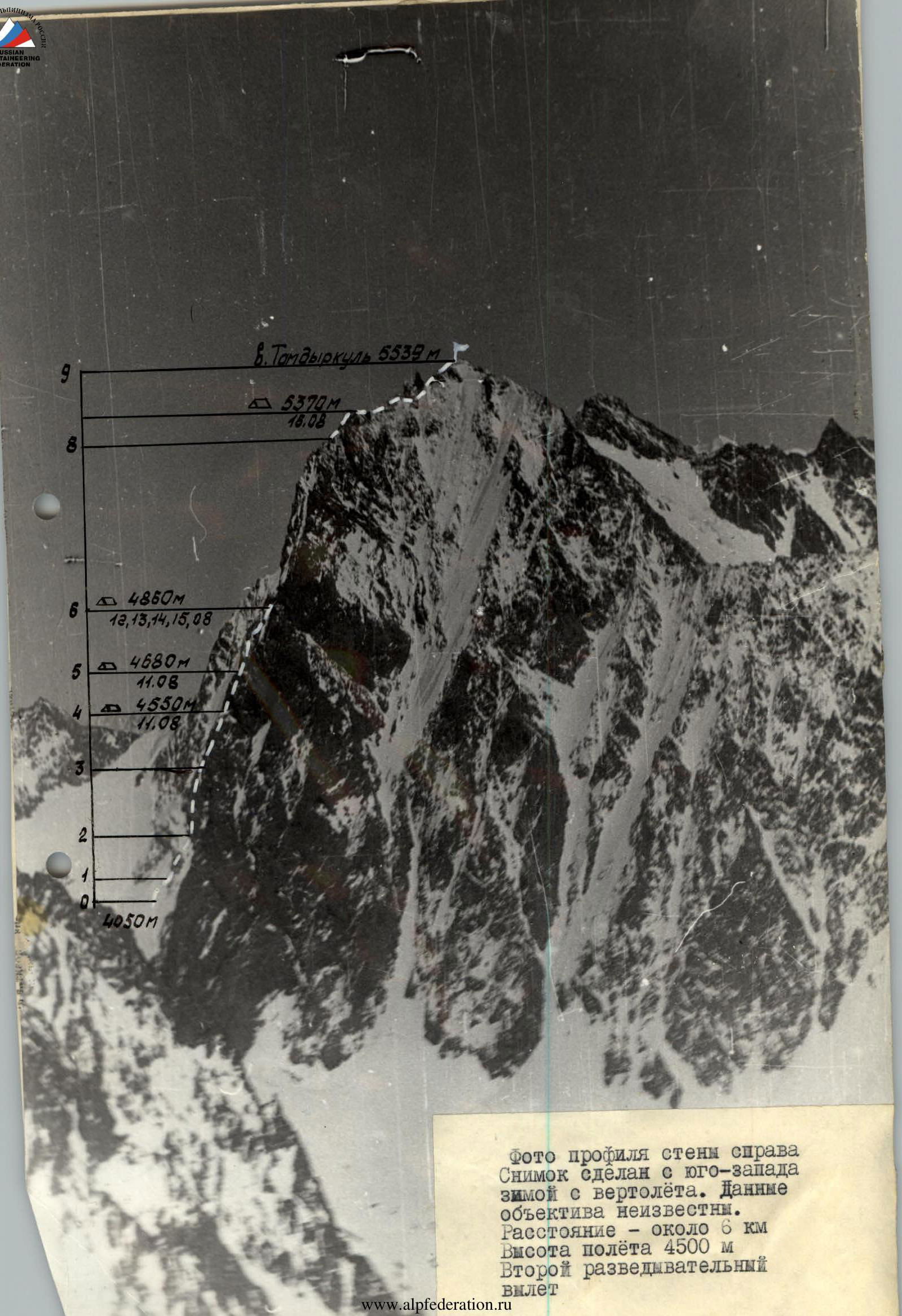
Photo of the wall profile from the right. Taken from the southwest in winter from a helicopter. Lens data unknown. Distance — about 6 km, flight height — 4500 m. Second reconnaissance flight.
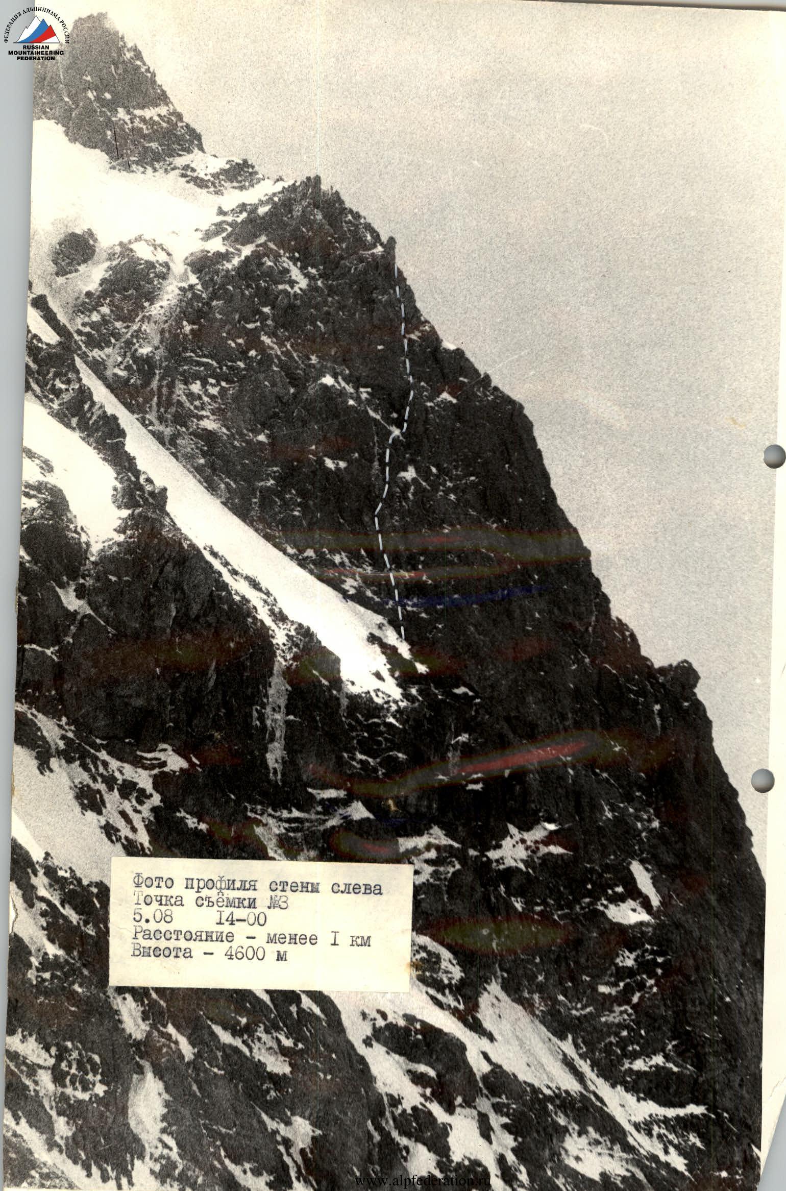
Photo of the wall profile from the left. Shot point #3. August 5, 14:00. Distance — less than 1 km, height — 4600 m.
Photopanorama. Taken from the southwest in winter from a helicopter. Shot point and camera data unknown. First reconnaissance flight.
Brief overview of the climbing area
Tamdykul peak is located in the western part of the Alay Range. The highest point of this area of the range is a place where the dry Pamir air mixes with the air masses of the Fergana Valley, which determines the local microclimate. There are two classified routes to the peak, but the area is practically not visited by climbers. From the northwest, from the Archabashi glacier, which is often visited by tourists traveling from Jirgatal to Sokh and back, the peak, and even more so the wall, is not visible, as it is hidden by a lateral spur of the range. Therefore, the NW wall did not attract the attention of climbers earlier.
Possible approach routes:
- Fergana — Khaydarkan — Sokh — Kan by car, then Zar-Daly — Shudman — Archabashi glacier on foot, 10–14 hours with a load;
- Jirgatal — Karagushkhana gorge — by car to the end of the road, then through Karagushkhana pass to Archabashi glacier, 8–10 hours.
To save energy and time, our team was transported to the Archabashi glacier by helicopter from Khaydarkan (25 minutes of flight). We set up a base camp at the landing site in line with the Western Tamdykul glacier. From the camp, the approach to the NW wall of the peak goes through a rocky step and a hanging tongue of the Western Tamdykul glacier. The approach is quite challenging; for multiple trips, we had to hang 7 ropes and a five-meter ladder, taking 3–4 hours.
 www.alpfederation.ru ↗
Technical data by sections
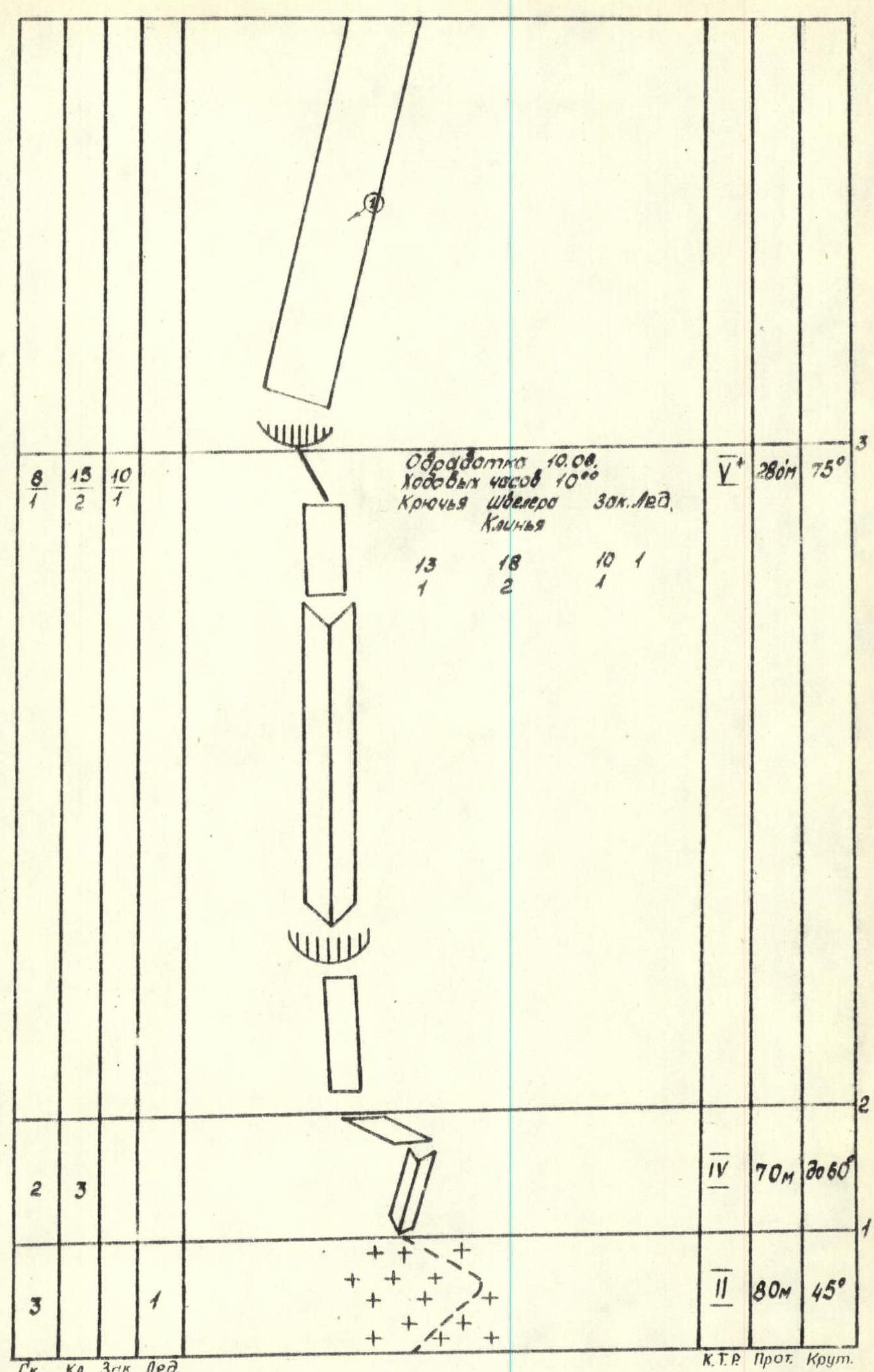
Preparation on August 10:
- Climbing hours: 10
- Pitons used (rock/wedges/chocks/ice screws): Rock 8, Wedges 15, Chocks 10.
- Section 1: category of difficulty 2, length 80 m, steepness 45°
- Section 2: category of difficulty 4, length 70 m,
- Section 3: category of difficulty 5, length 280 m, steepness 75°
Preparation on August 11:
- Climbing hours: 12
- Pitons used (wedges/channels/chocks): Wedges 47, Channels 33, Chocks 21.
- Section 4: category of difficulty 5, length 230 m, steepness 70°
- Section 5: category of difficulty 5, length 150 m, steepness 70°
- Section 6: category of difficulty 3, length 80 m,
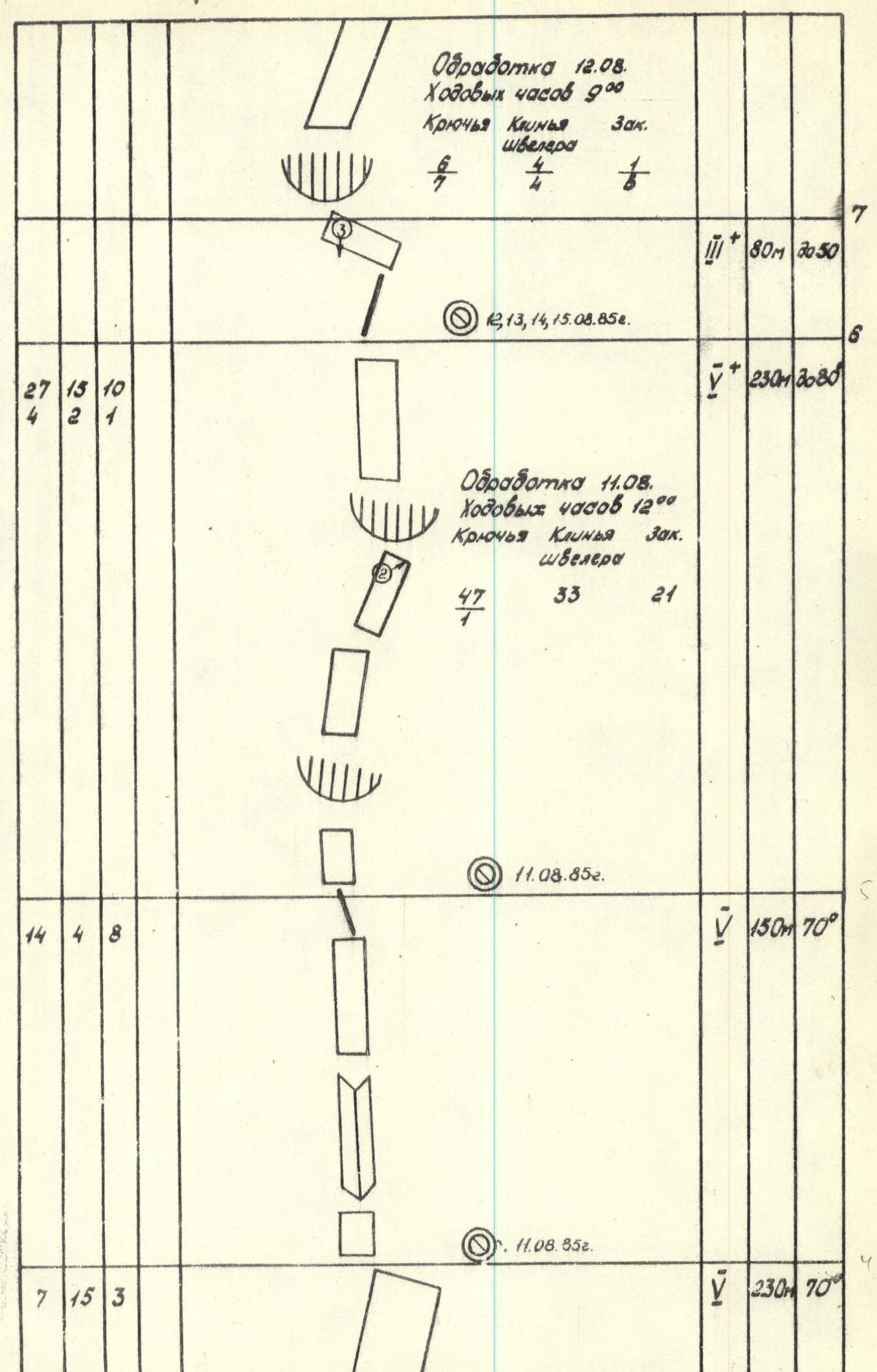
Preparation on August 13:
- Climbing hours: 10
- Pitons used (wedges/channels/chocks): Wedges 27, Channels 11, Chocks 22.
- Section 7: category of difficulty 3, length 450 m, steepness 30°
Preparation on August 16:
- Climbing hours: 13
- Pitons used (wedges/channels/chocks/ice screws): Wedges 22, Channels 18, Chocks 6, Ice screws 2.
- Section 8: category of difficulty 6, length 500 m, steepness 80°
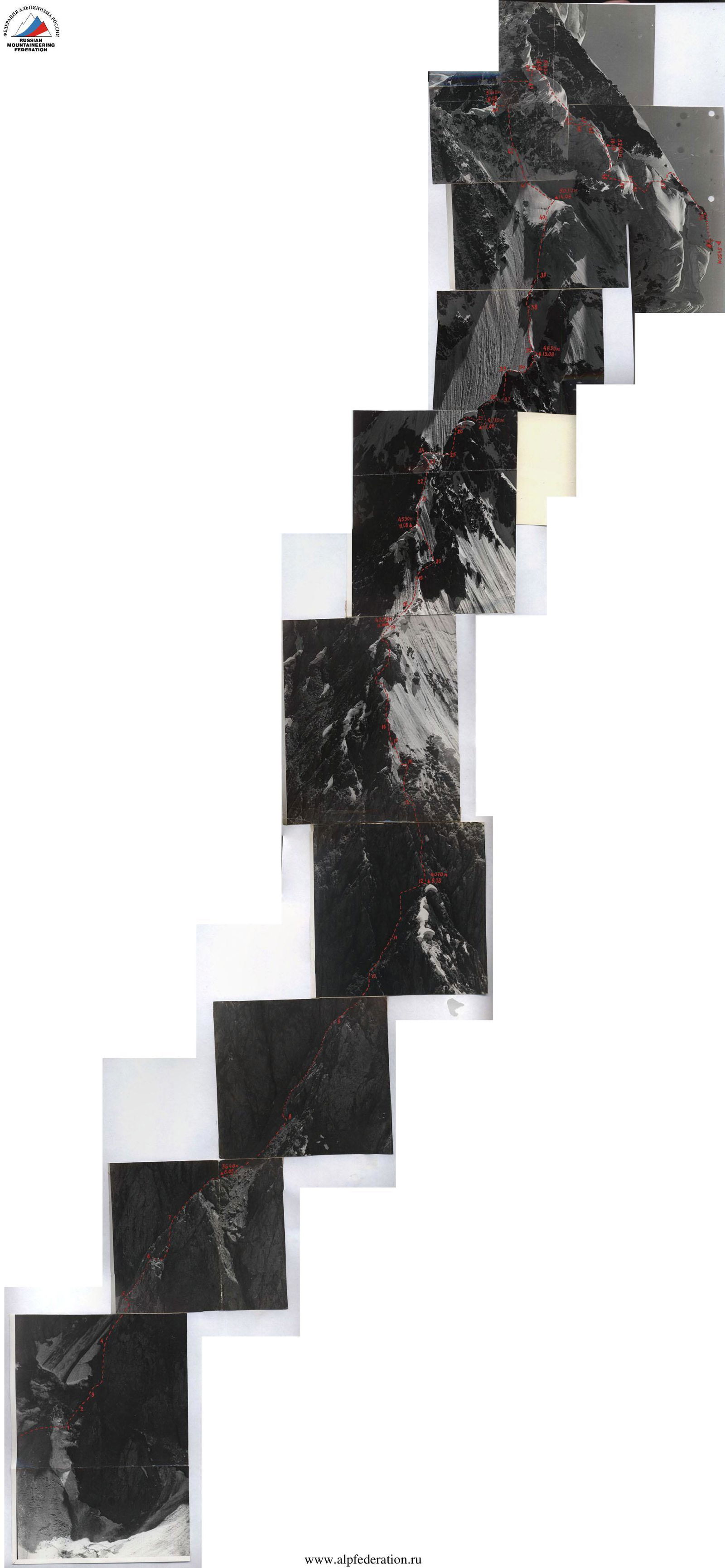
Description of the route by sections
Section 2–3. The entire section is characterized by a purple sheen. The rocks are monolithic. The smooth wall leads under an overhang, which is passed using artificial aids. Backpacks were hung from the harness when passing the rope in this place. Further, a very wide internal angle begins, at the end of which the route passes along its left edge-wall, leading to a gentle ridge, leading to the next section.
Section 3–4. Begins with a small destroyed overhang, turning into a wall, strongly dissected, but smoothed, cracks are usually filled with ice.
Section 4–5. The relief is varied and pronounced. Many loose rocks. Other equivalent options for passing it are possible. The one we took is the most direct.
Section 5–6. Technically more complex than those passed earlier. In the upper third, it is intersected by two converging cornices from left to right. The direction of movement is along smooth walls through a small overhang under the cornices and then to the right under the lower cornice along a smooth slab to the junction of both, where the route is a complex block overhang and pitons can be driven. The first used artificial aids. Passing the overhang along the rope with self-pulling, backpack on the harness. Above the overhang, a destroyed wall requires very careful passage.
Section 6–7. Does not present technical difficulties. From the end of the combined ridge, resting against a bastion, a traverse to the left and upwards along a smooth slab to a shorter part of the overhang, crossing the route.
Section 7–8. Begins with an overhanging wall. The rocks are very destroyed (negative scree, in the vivid expression of team members). Due to the destruction, there are great difficulties with driving pitons. When passing the rope, additional insurance is necessary, and backpacks had to be transported on the back to avoid causing rockfall. Behind the overhang, there is a fairly smooth, extended wall, dissected by cracks filled with ice. Organizing insurance is very difficult. First, straight up, then bypassing the overhang to the left and upwards, and again straight to the crevice, leading under a smooth wall, dissected by a vertical crack, leading to a snow-ice shelf. Here, the preparation ended on August 13, and here the first had to finish working in galoshes. After bad weather, the rocks became unrecognizable, and the first one's further work was mainly in crampons. A traverse to the right along the snow-ice shelf leads to a cornice. From the ice, the first climber, Tsoy, changed into galoshes and went straight up along the internal angle in the upper part, overhanging and covered by a cornice. Having secured the rope and descended 3 m with a pendulum, he swung over a smooth monolithic ridge into the right internal angle, ending in a crevice passing through the cornice. The rest followed the straightened ropes, swinging under the right internal angle with a pendulum (see supplement). Behind the cornice, a series of large blocks with smooth front surfaces turns into a smooth, almost crack-free, heavily iced wall, leading to an internal angle with a slightly overhanging, but clean of ice, edge, where pitons were driven, facilitating insurance organization. The internal angle turns into an ice-filled chimney, ending on the ridge.
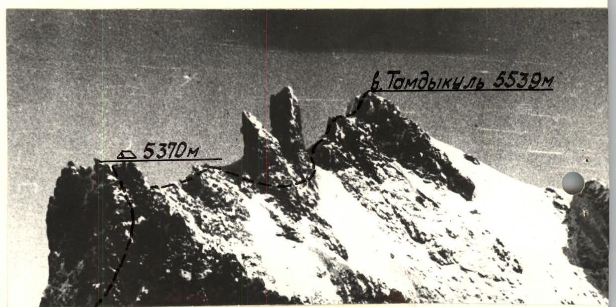
Section 8–9. At first, the ridge is heavily cut, with many pinnacles. It goes along the right side, with a southwest exposure, so only occasionally ice grooves are encountered. After an overnight stay, an almost horizontal scree ridge leads to a huge two-pronged pinnacle, which is bypassed on the right along the wall. Behind the pinnacle, an ice slope leads again to the ridge, and destroyed rocks with snow lead to the summit. The summit is a small triangular plateau with three almost equal elevations at the corners. No note was found on the summit, although there are signs of people being there (torn rope, matches). We left a note at the overnight stay under the bastion "control tour" and on the southwest elevation of the summit, which seemed to us the highest.
Descent along the heavily cut, destroyed southwest ridge.
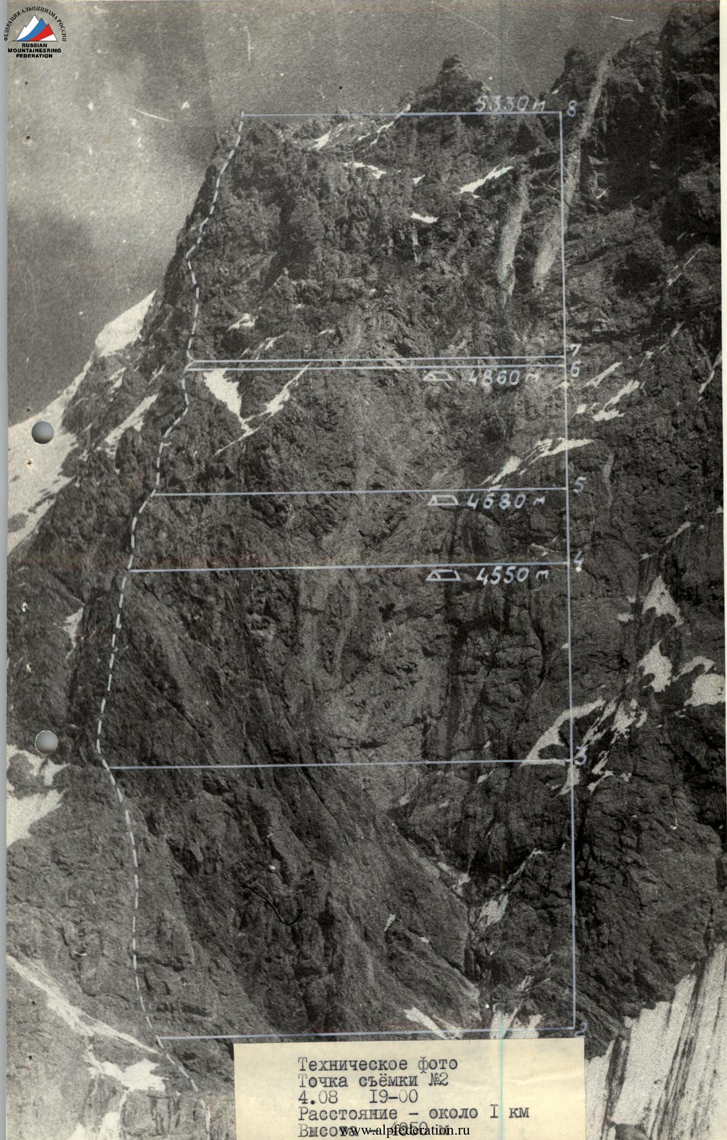
Technical photo. Shot point #2. August 4, 19:00. Distance — about 1 km.
Section of the ridge. Retaken from a photograph taken in winter from a helicopter. The film was lost, camera data and shot point unknown, scale not maintained.
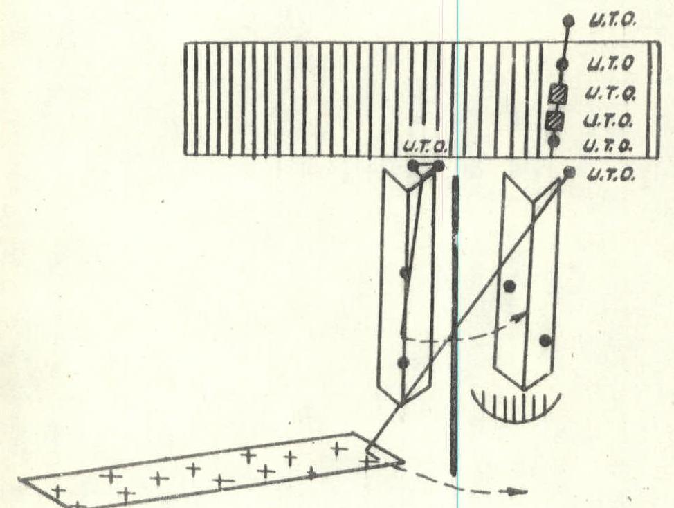
Scheme
Passing the cornice
on section 7–8
Scale 1:100
 Tamdykul peak is located approximately forty kilometers northeast of the district center Jirgital (about 250 km from Dushanbe), where there is a dirt airfield with a helicopter base. From here, you can drive by car (20 km) to the former kishlak Tamdykul and a dairy farm, i.e., almost to the entrance to the Ishtan-Saldy gorge.
From here, along the left orographic bank of the Ishtansaldy River to the confluence with the river, the source of which is the "Inaccessible" glacier:
- The river cannot be forded due to the rapid current.
- It is necessary to set up a suspended rope crossing — about 20 m.
- Further along the Ishtansaldy River, and then along the left-bank moraine of the Tamdykul I glacier, 1.5–2 hours to the springs, located at an altitude of 2700 m.
- From here, it is necessary to turn sharply to the right and reach a convenient place for a base camp on the median moraine of the Tamdykul glacier in 1.5–2 hours.
Considering the transportation of goods for organizing a base camp without using a helicopter, it takes two days.
Weather conditions
From books about the Pamir-Alay, it is known that this outskirts of the Pamir is characterized by unstable weather with sharp changes even during the daylight hours. Often the valley is lit by the sun, while the peaks of Tamdykul and adjacent peaks are covered by clouds for the whole day. Here, calm weather is rare. In the valleys, a light air movement begins in the morning, mainly towards the upper reaches of the glacier, which by the end of the day often turns into a stormy wind. Periodically, the "Afghani" wind blows in, and then the air is saturated with dust for several days, from which it is difficult to hide. Fortunately, the "Afghani" always ends with rain, which refreshes nature. In the highlands of this area, continuous winds are characteristic. In the gorges, the wind dies down by morning, but above 4000 m, even the walls of neighboring peaks do not protect climbers from piercing winds.
Relief features
The area in question is interesting because, due to the large differences in altitude between the upper reaches of the gorges and the peaks of the range, it is difficult to choose a route that would contain a limited number of elements of mountain relief, for example, a purely rocky wall or a snow-ice slope from the foot to the summit. The rocky sections of the route, due to the fact that the mountain is composed of deeply metamorphosed shale rocks and partly their lava rocks, require great caution from the participants. For footwear, it is best to use boots with rubber soles (meaning rocky sections).
Comments
Sign in to leave a comment