
"Chelyabinsk Worker" via Uraltsev Pass along the southern wall cat. diff. Dzhura A.A. +2 Ims_ms@mail.ru Kichik-Alay ridge 5.1.4
Photo № 1: Peak "Chelyabinsk Worker" (taken on July 21, 2008 from the summit of p. Irbis 4200 m)
 ascent route
. . . . . invisible ascent route — descent route
ascent route
. . . . . invisible ascent route — descent route 5.1.4. Kichik-Alay ridge, Dzholdzhilga gorge. "CHELYABINSK WORKER" peak 4420 m via Uraltsev Pass along the southern wall, first ascent
(DEDICATED TO THE 100th ANNIVERSARY OF THE OLDEST REGIONAL NEWSPAPER)
Proposed: 2B cat. diff.
Route character: combined
Altitude difference according to the group's altimeter — 220 m,
including northern slope — 150 m;
southern wall — 80 m
(starting point on the wall is 10 meters below the saddle, on the southern side of the ridge)
Route length — 480 m (estimated),
including southern wall — 90 m;
rock section of III cat. diff. — 45 m
Average steepness of the entire route — 37°;
including northern slope — 35°;
southern wall — 53°.
For belaying on the ascent, in addition to natural features, 6 placements of chocks were used
(no artificial climbing aids; no belay points were left behind)
5.1.4. Kichik-Alay ridge, Dzholdzhilga gorge. "CHELYABINSK WORKER" peak 4420 m via Uraltsev Pass along the southern wall, first ascent
(DEDICATED TO THE 100th ANNIVERSARY OF THE OLDEST REGIONAL NEWSPAPER)
Proposed: 2B cat. diff.
Route character: combined
Altitude difference according to the group's altimeter — 220 m,
including northern slope — 150 m;
southern wall — 80 m
(starting point on the wall is 10 meters below the saddle, on the southern side of the ridge)
Route length — 480 m (estimated),
including southern wall — 90 m;
rock section of III cat. diff. — 45 m
Average steepness of the entire route — 37°;
including northern slope — 35°;
southern wall — 53°.
For belaying on the ascent, in addition to natural features, 6 placements of chocks were used
(no artificial climbing aids; no belay points were left behind)
Leader: Dzhura Alexander Alexandrovich (2nd sports category) — St. Petersburg Participants:
- Gorshkov Vladimir Alexandrovich (1st sports category) — Chelyabinsk
- Medvinskaya Ekaterina Alexeevna (2nd sports category) — St. Petersburg
Senior coach: Levin Mikhail Semenovich, Master of Sports (1st cat. № 36) — Chelyabinsk
Climbing hours / days on the route: 2.7 / 1 from base camp (3020 m) to the summit: 9.7 / 2 (including descent to base camp — 15.0 / 2) July 16, 2008 from base camp (3020 m) to upper bivouac 3470 m — 3.0 (12:00–15:00) July 17, 2008 from bivouac to Uraltsev Pass 4200 m — 4.0 (5:00–9:00) From Uraltsev Pass to saddle 4370 m — 1.7 (9:15–10:55) from saddle to summit 4420 m — 1.0 (11:00–12:00) descent to bivouac 3470 m — 3.0 (12:30–15:30)
Photo 2: technical photograph of the southern wall, taken on September 5, 1974 from the western ridge of Tavriya (sorry, but there are no other photos from the south!)
- ascent route
-
-
- invisible ascent route
-
-
-
-
- descent route
-
-
Photo 3, 4: technical photographs of sections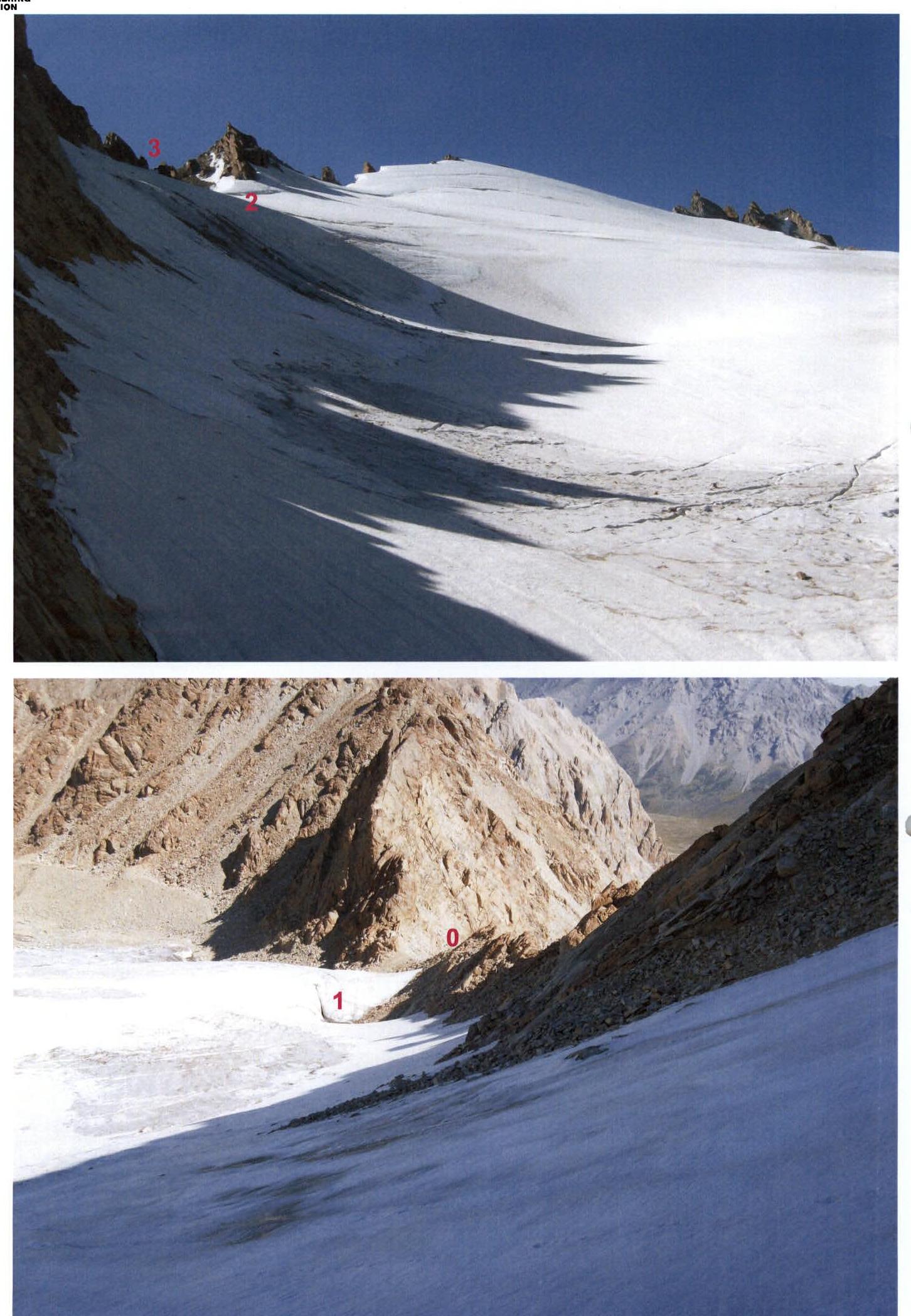 Photo 5, 6: technical photographs of sections
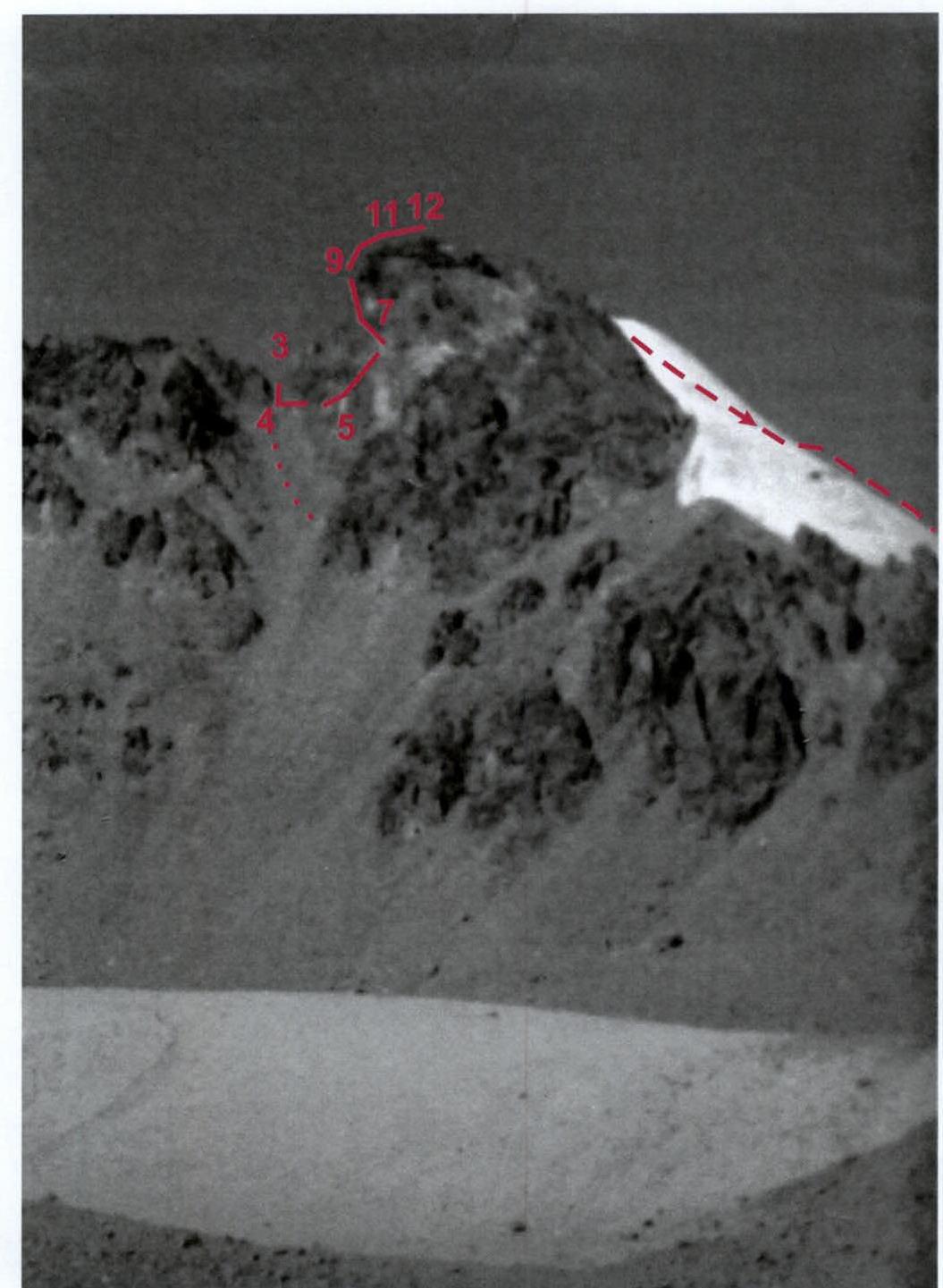
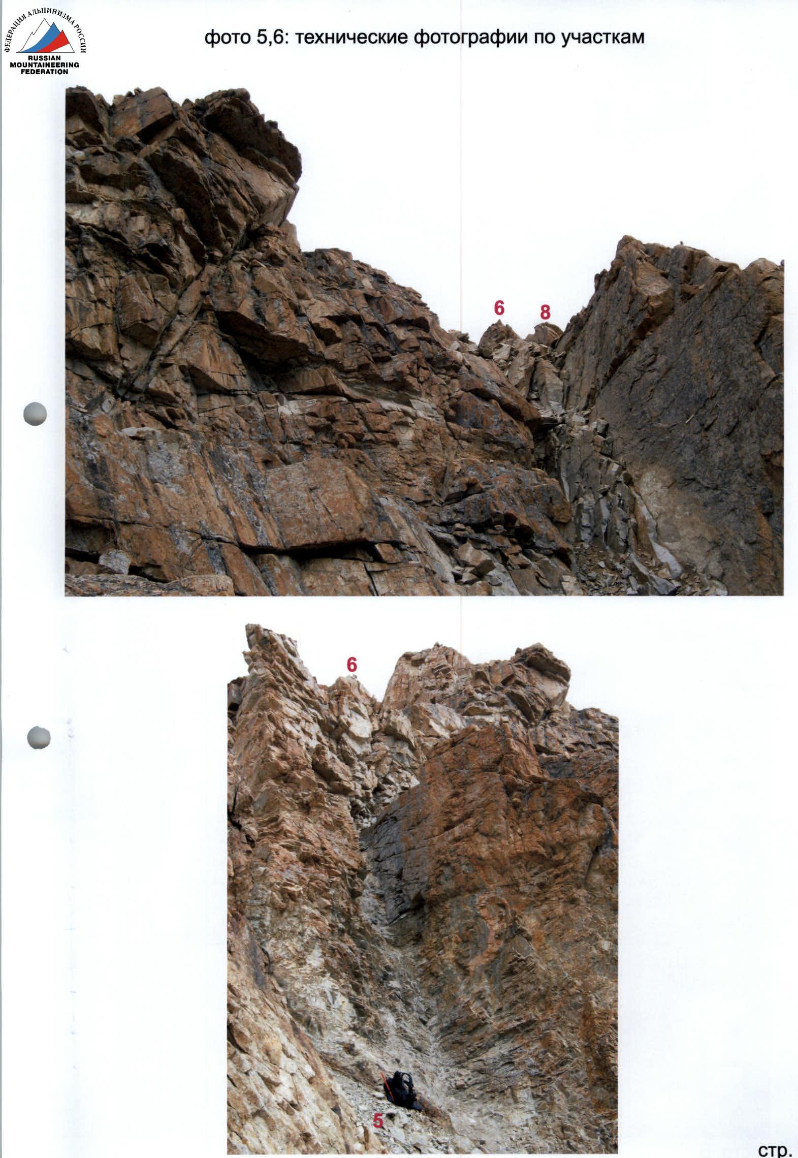 Photo 7, 8: technical photographs of sections
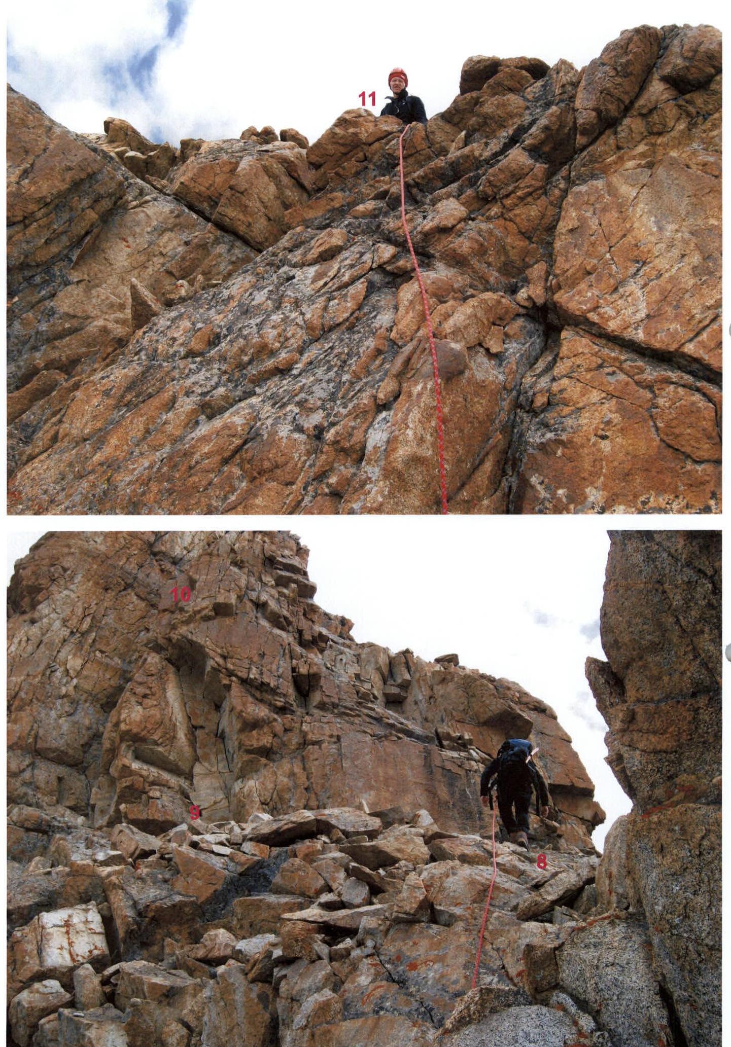 Photo 9: route profile from the left
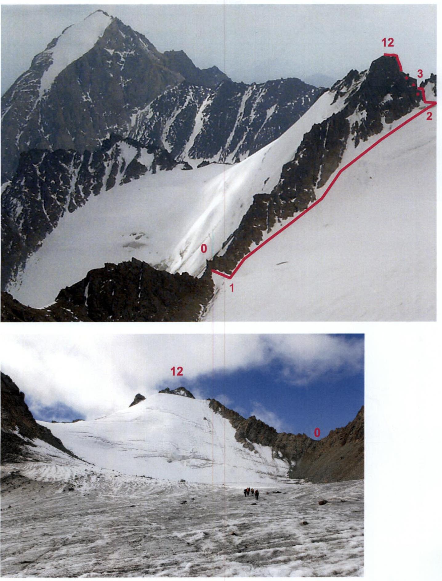
Photo 9-a: on the way to the route 1–6 cat. diff. To the right — Uraltsev Pass. Taken on July 25, 2008 from under peak Karatash.
DRAWN ROUTE PROFILE OF THE FIRST ASCENT to peak "CHELYABINSK WORKER"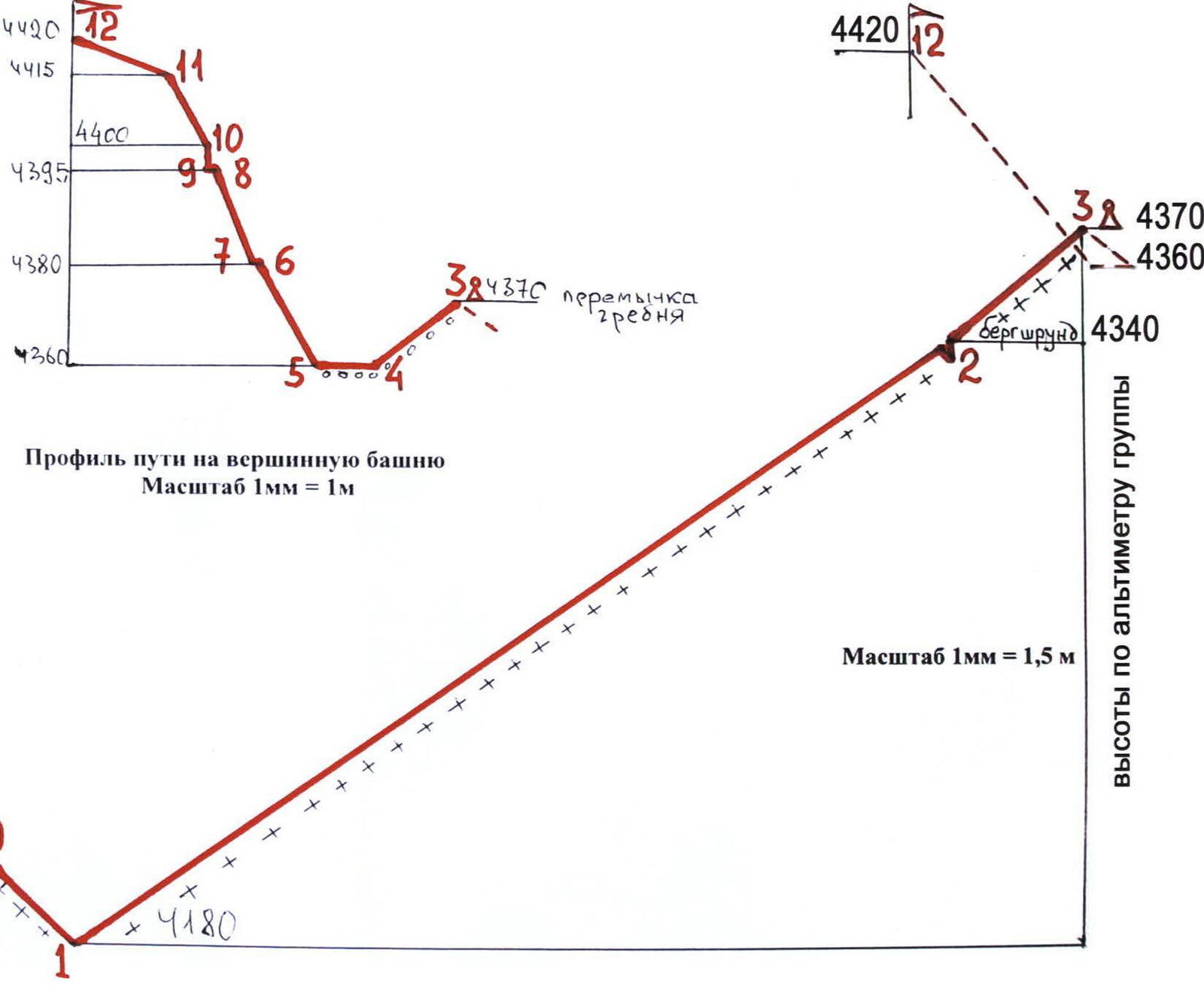
Photo 10, 11: PANORAMA OF THE AREA (taken from the west)
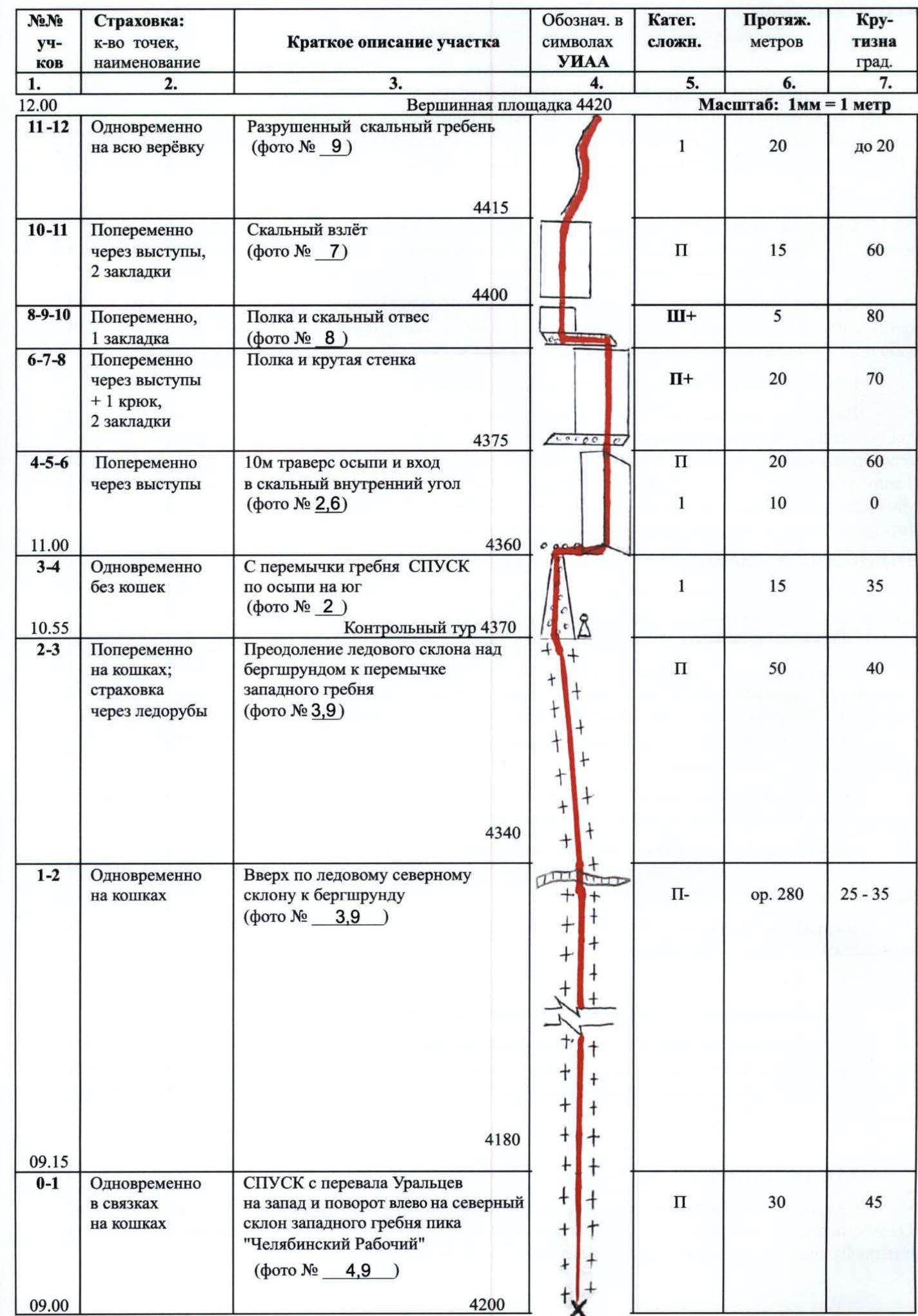
Map of Kyrgyz-Ata gorge (Kichik-Alay ridge) scale 1:50 000
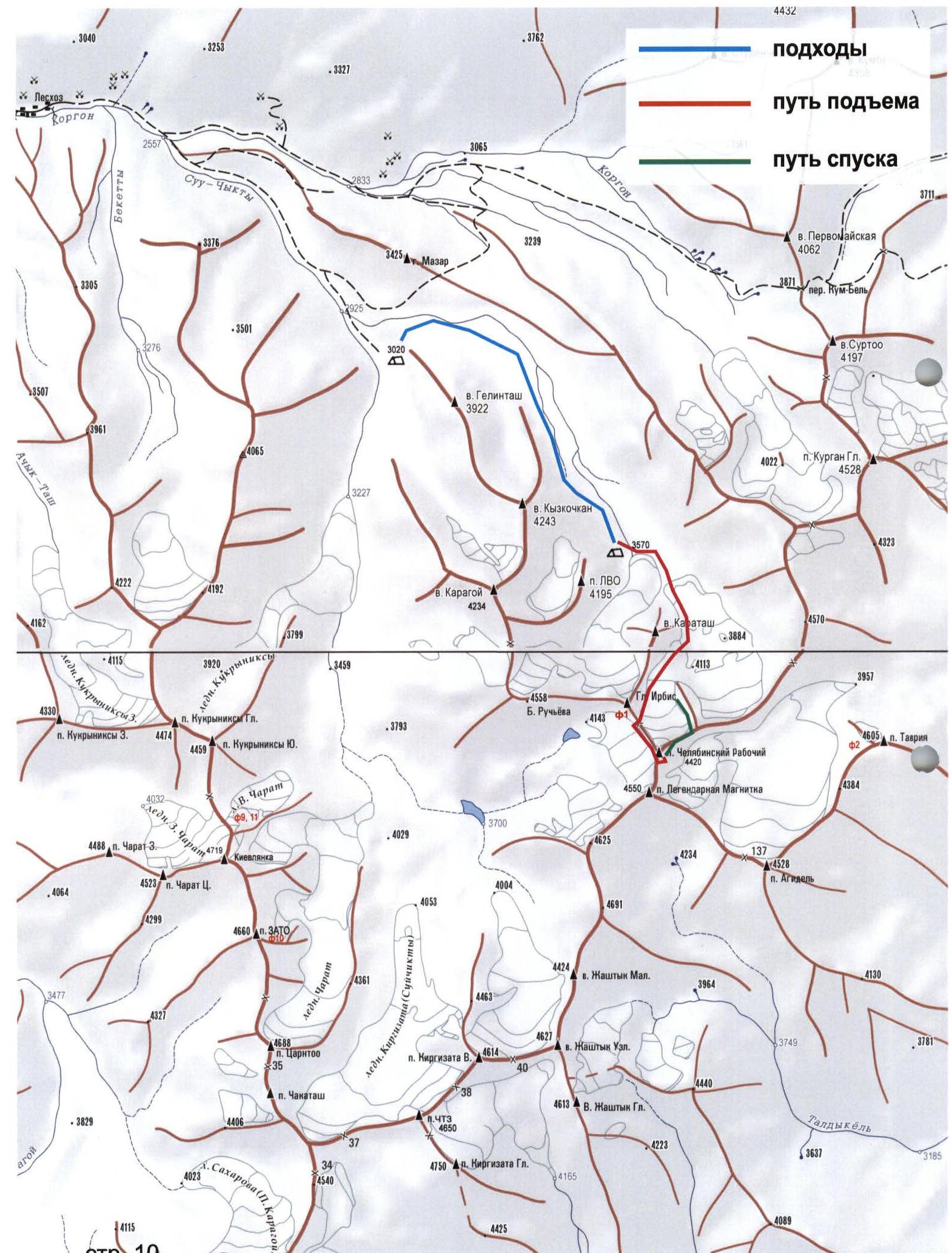
TABLE OF MAIN CHARACTERISTICS in UIAA symbols
- first ascent of the southern wall of peak "Chelyabinsk Worker"
| №№ sections | Belaying: number of points, name | Brief description of the section | Designation in UIAA symbols | Cat. diff. | Length meters | Steep-ness deg. |
|---|---|---|---|---|---|---|
| 12:00 R11–R12 | Simultaneously on the entire rope | Summit area 4420 Destroyed rocky ridge (photo № 9) | 1 | 20 | up to 20 | |
| R10–R11 | Alternately through natural features, 2 chocks | Rocky ascent (photo № 7) | 2 | 15 | 60 | |
| R8–R9–R10 | Alternately, 1 chock | Shelf and rocky steep section (photo № 8) | 3 | 5 | 80 | |
| R6–R7–R8 | Alternately through natural features + 1 hook, 2 chocks | Shelf and steep wall | 2 | 20 | 70 | |
| R4–R5–R6 | Alternately through natural features | 10 m traverse of talus and entry into rocky inner corner (photo № 2, 6) | 2 | 20 | 60 | |
| 1 | 10 | 0 | ||||
| 11:00 R3–R4 | Simultaneously without crampons | From the saddle of the ridge DESCENT along talus to the south (photo № 2) | 1 | 15 | 35 | |
| 10:55 R2–R3 | Alternately with crampons; belaying through ice axes | Control cairn 4370 Overcoming ice slope above the bergschrund to the saddle of the western ridge (photo № 3, 9) | 2 | 50 | 40 | |
| R1–R2 | Simultaneously with crampons | Up along the icy northern slope to the bergschrund (photo № 3, 9) | 2 | 280 | 25–35 | |
| 9:15 R0–R1 | Simultaneously in teams with crampons | DESCENT from Uraltsev Pass to the west and turn left to the northern slope of the western ridge of peak "Chelyabinsk Worker" (photo № 4, 9) | 2 | 30 | 45 | |
| 9:00 |
Brief Description
New Route to peak "Chelyabinsk Worker"
A) Approach
At the lower boundary of the forest in Kyrgyz-Ata gorge, where a stone unfinished building is near Aman yurt, the automobile road ends. Cow trails from here lead through the juniper forest down to the confluence of Suichikty and Dzholdzhilga streams. After crossing the last Dzholdzhilga stream over rocks, the first large clearing is equipped by Chelyabinsk residents in 1977 as base camp "3000"; unfortunately, now herders drive their herds across the clearing (Kyrgyz people have become rich!), and we had to set up camp a bit higher.
B) Approach march
From base camp 3020 m upwards to the northeast, bypassing the Gelintash massif on the left, then along the left (or.) side of Dzholdzhilga gorge past the walls of Kyzkochkan and LVO. In the upper reaches, cross to the green clearings at the left edge of the terminal moraine of Dzholdzhilga glacier — here is bivouac 3470 m.
From here, early in the morning, upwards and across moraines, completely bypassing the Karatash massif on the left, then to the left along the eastern slopes of p. Irbis to the gap 4200 m in the northern ridge of the tower of p. "Chelyabinsk Worker" — this is Uraltsev Pass (4 hours from bivouac), behind it — the beginning of the actual route.
From the pass, descend to the west in teams with crampons.
Alternative: the ascent can be made from the lakes of Suichikty gorge – to them 3–4 hours along grassy slopes and moraines to the south to the left edge of the large terminal moraine blocking the gorge. At the lower lake — sites 3700 m (according to the group's altimeter). From here between the talus slopes of p. Boris Ruchyev and the snowy-icy walls of the ridge of p. Legendary Magnitka to the east, to the glacier descending from Uraltsev Pass to the west. From under the pass the actual route of the described ascent begins.
C) Route passage
West of the pass to the south and in teams with crampons up the snowy-icy slope simultaneously along the rocks of the northern ridge of the tower to the bergschrund. Through the bergschrund with belaying through an ice axe to the saddle 4370 m of the western ridge (1.5–2 hours from the pass).
The rocky ascent of the tower from the saddle is not feasible: rocks are of 5 cat. diff.! Descend along talus down to the south and in traverse to the left, enter the 20-meter inner corner of the southern wall. Rocks are unreliable — use camming devices! Above the corner — a shelf, from which a steeper 20- meter wall begins. Above it, along the next shelf to the left to a 5-meter steep section with fractures — from here again opens a view to the north.
Along steep destroyed rocks, exit to less steep rocks of the pre-summit ridge and to the cairn on the highest point (1 hour from the saddle of the western ridge).
Descent along the route 1B cat. diff.:
- with crampons to the east along the "sickle" with belaying through ice screws;
- then to the north under the eastern slope of Uraltsev Pass;
- further along the known path (3 hours from the summit to bivouac 3470 m).
Descent alternatives:
- descent to Suichikty gorge through Uraltsev Pass;
- three rappels to the south along the ascent route.
Recommendations for equipment use and safety
We took more equipment than needed; a set of chocks and 4 ice screws for descent would have been sufficient. On the southern wall, careful loading of supports is required from the leader, although the terrain allows arranging belay stations such that accidentally dropped stones by the climber pass by.
Conclusion
The best route in the area for acclimatization-training ascent!
The southern edge of Cheget-Kara 2B cat. diff. is very similar, especially if the ascent starts from Suichikty gorge: then also a descent by ropes along the ascent route.
Necessary explanation
From 1975–1984, Chelyabinsk regional courses of the highest mountaineering skills, created in 1972 by MS Levin M.S., were engaged in the development of the upper reaches of Kyrgyz-Ata valley. He was assisted by MSMK G.K. Rozhalskaya, MS M.F. Levina, MS V.I. Mironov, MS A.B. Nelidov, MS V.G. Tarkhanov, CMS V.G. Mironov, CMS N.P. Yakovleva and others.
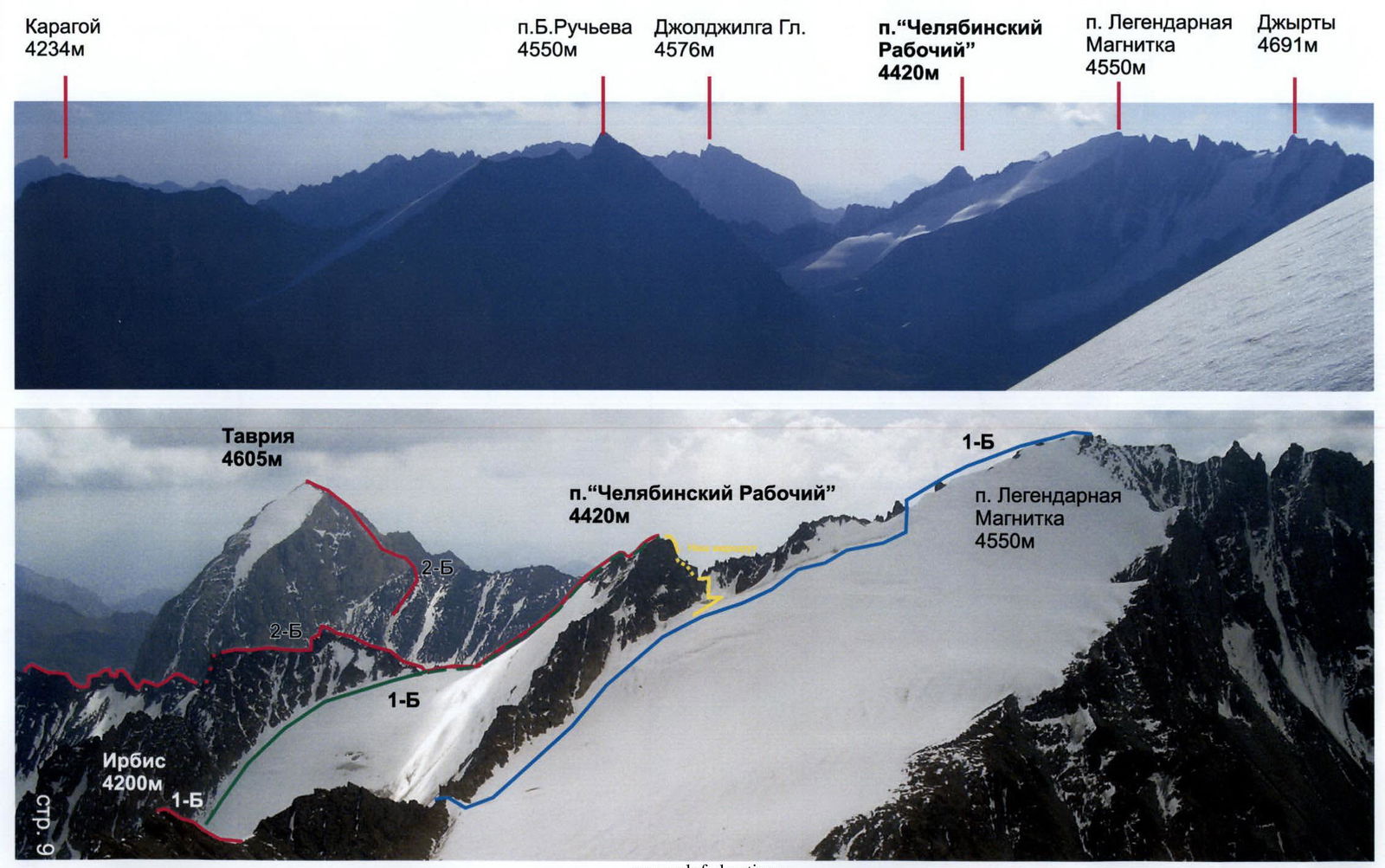
In accordance with existing traditions, the peaks were given names:
- of Soviet leaders (Vasenko, Kadomtsev and others);
- writers and artists (I. Efremov, B. Ruchyev, Kukryniksy);
- "Legendary Magnitka";
- newspaper "Chelyabinsk Worker" and so on.
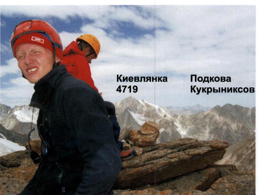
For the publication of a guidebook on Kichik-Alay ridge, Chelyabinsk residents provided A.F. Naumov with a map, corrected by M.S. Levin and N.V. Averina, hundreds of photos and photopanoramas, dozens of descriptions of first ascents and first passages. Unfortunately, the publisher did not always handle the proposed peak names correctly: for example, it was not necessary to destroy the names given by Chelyabinsk residents, nor to introduce names like "Kukryniksy-Western", even more absurd "Kievlanka-Southern" and so on.
In 2008, M.S. Levin planned a first ascent for our sports team to peak "CHELYABINSK WORKER" to commemorate the 100th anniversary of the oldest regional newspaper.
On August 26, 1977, this then-unnamed peak was traversed by a group of climbers from Chelyabinsk region led by mountaineering instructor CMS Mironov V.G., released by M.S. Levin on a first ascent from Dzholdzhilga Pass, from the East, to peak 4550 m ("Legendary Magnitka").
After the group's return, it became clear that the "nodal unnamed peak", the slopes of which descend into 4 different gorges, should have its own name.
It was proposed by M.S. Levin, and the group of S. Belkov on September 7, 1977, ascended to the summit 4420 m from the north and named it "peak CHELYABINSK WORKER".
This route, classified as 1B cat. diff., was repeated in the jubilee year 2008 by two groups from Chelyabinsk. Unfortunately, Gorshkov V.A., who was entrusted with the leadership of the described first ascent from the south to peak "CHELYABINSK WORKER", ignored the instructions of the release officer (mountain sickness?), failed to cope with the leadership, and therefore it was credited to Dzhura A.A. who led.
Comments
Sign in to leave a comment