
Ascent Log
- Ascent class: technical
- Ascent area: Pamir-Alay ridge, Kychyk-Apai area
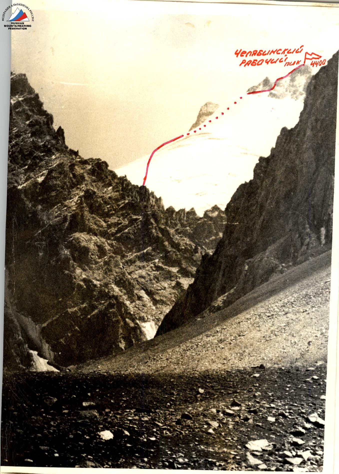
- Peak: Chelyabinsk Worker peak (first ascent). Height 4400 m. Ascent route: from the north along the ice slope.
- Proposed difficulty category: 2A
- Route characteristics: height difference 1200 m from the assault bivouac, length of sections 5–6 km, average steepness 35°.
- Number of pitons: for belaying — _, for creating ITO — _ Rock — _, ice — _, bolt — _
- Number of travel hours: 4 h 14 min.
- Number of overnight stays and their characteristics:
- Full name of the leader, participants, and their qualification:
- Belkov S.A. — leader, 3rd sports category
- Volodko A.A. — 2nd sports category
- Kandyuk S.A. — 2nd sports category
- Sherstobitov A.S. — 2nd sports category
- Team coach: Master of Sports Levin M.S.
- Date of departure and return: September 7, 1977 — September 7, 1977
42
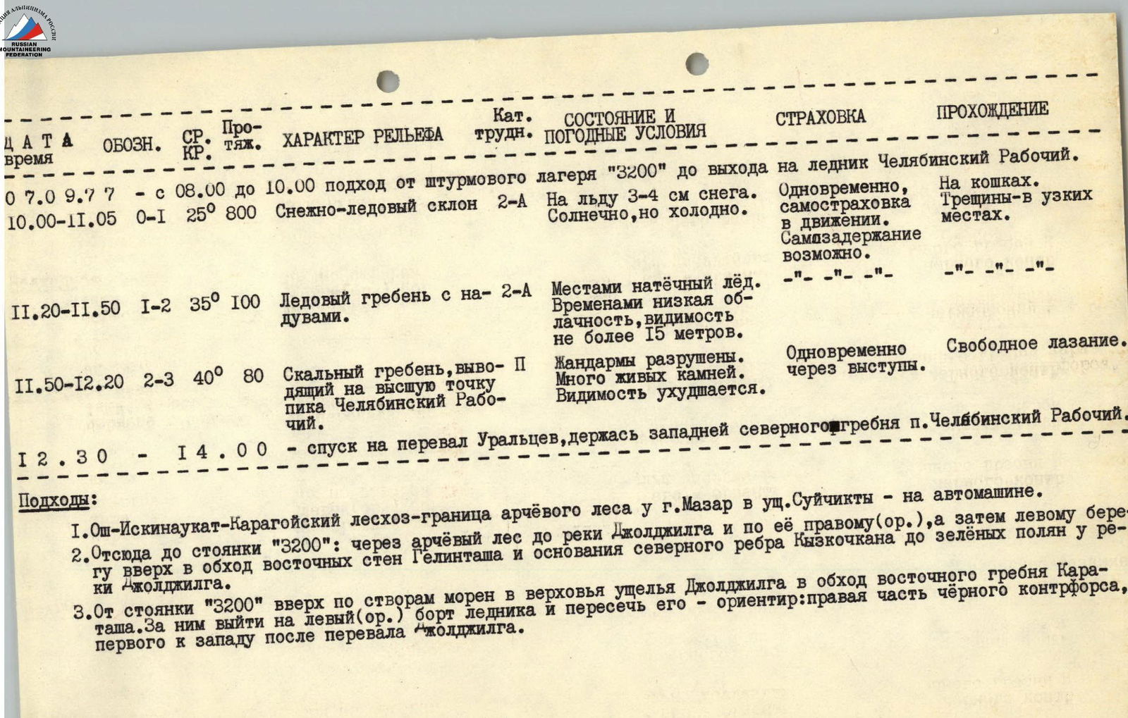
September 7, 1977 from 8:00 to 10:00: approach from the assault camp "3200" to the exit to the Chelyabinsk Worker peak glacier. Traveled on crampons.
| Time | Designation | Steepness | Length, m | Terrain characteristics | Difficulty category | Condition and weather conditions | Belaying | Passage |
|---|---|---|---|---|---|---|---|---|
| 10:00–11:05 | R0–R1 | 25° | 800 | Snow-ice slope | 2A | 3–4 cm of snow on the ice. Sunny, but cold. | Simultaneous, self-belaying in motion. Self-arrest possible. | Crevasses — in narrow places. |
| 11:20–11:50 | R1–R2 | 35° | 100 | Ice ridge with drifts | 2A | местами натёчный лёд. Occasional low clouds, visibility not more than 15 meters. | — | — |
| 11:50–12:20 | R2–R3 | 40° | 80 | Rock ridge leading to the highest point of Chelyabinsk Worker peak | 1 | "Жандармы" are destroyed. Many loose rocks. Visibility deteriorates. | Simultaneous through ledges. | Free climbing. |
12:30–14:00 — descent to the Uraltsev pass, holding west of the northern ridge of Chelyabinsk Worker peak.
Approaches:
- Osh — Iskinaukat — Karagoy forestry — border of the juniper forest near the city of Mazar in the Suichikty gorge — by car.
- From here to the "3200" camp: through the juniper forest to the Joldjilga river and along its right (orographic), and then left bank upstream, bypassing the eastern walls of Gelintash and the base of the northern edge of Kyzkochkan to the green glades near the Joldjilga river.
- From the "3200" camp upstream along the moraine alignments to the upper reaches of the Joldjilga gorge, bypassing the eastern ridge, left (orographic) side of the glacier and crossing it — landmark: the right part of the black counterfort, the first to the west after the Joldjilga pass.
Comments
Sign in to leave a comment