ASCENT PASSPORT
- CATEGORY — TECHNICAL
- REGION — KICHIK-ALAI range
- PEAK — BORIS RUCHYOV peak 4555 m first ascent via the first northern couloir of the eastern spur (combined)
- Proposed difficulty category — 3A.
- Height difference — 600 m. Sections of 5th–6th diff. cat. — none. Average steepness — 45°.
- PITS SET:
- For belay:
- Rock — 2
- Ice — 2
- Bolt — none
- For creating ITO:
- Rock — none
- Ice — none
- Bolt — none
- For belay:
- Number of climbing hours (ascent) — 4 h 45 min.
- Overnight stays on the route — none.
- First ascent made by a team of two:
-
- BOCHKOV Vladimir Viktorovich — 1st sports category.
-
- SAMOKOTIN Yuri Timofeevich — 1st sports category.
-
- Coach: Master of Sports LEVIN M. S.
- Date of departure and return: July 18, 1981
NOTE: The route was repeated:
- 19.07.1981 (A. Danileiko, A. Prakhov);
- 23.07.1981 (G. Shchekalov + V. Zhmaev, M. Karpenkov, G. Tsybulevsky);
- 26.07.1981 (A. Fedyaev + 4);
- 05.08.1981 (T. Vakhitov + T. Stukhina). Event organized by the Chelyabinsk Regional Committee for Physical Education and Sports “CHOKVAM–81”.
CHELYABINSK REGION ALPINISM FEDERATION
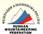
View from the Suychikty gorge
Ridge to Karatay
Route of the first ascenders 1st cat. diff. (1977)
Described route
Kukryniks (NO)
Peak Ruchyeva 4555
Peak Bratyev Kadomtsevykh 4691
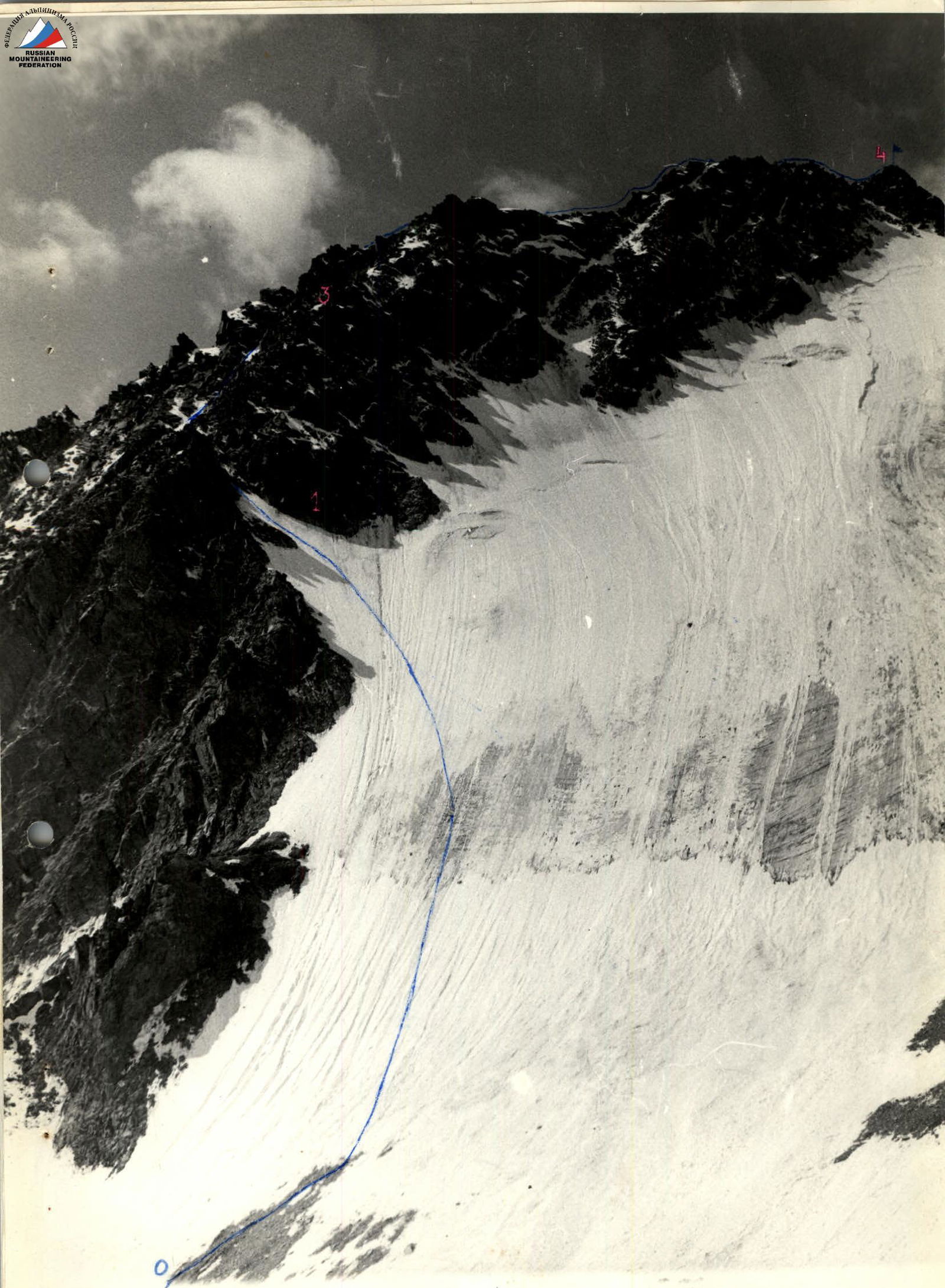
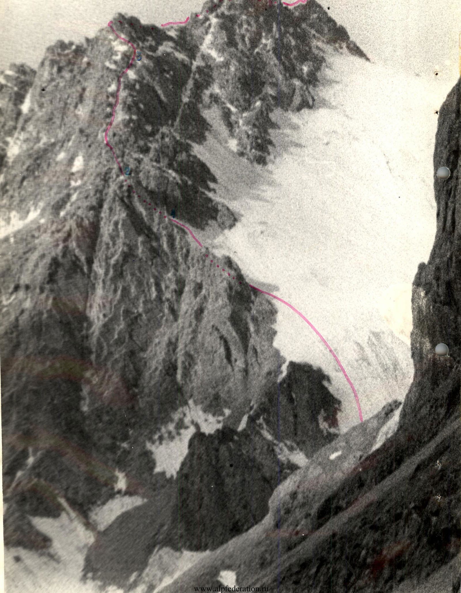
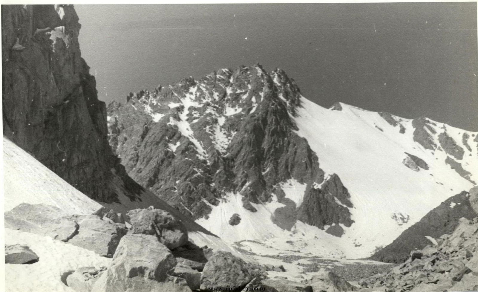
TABLE OF MAIN CHARACTERISTICS OF THE ROUTE to peak Boris RUCHYOV via the 1st N. couloir of the E. spur
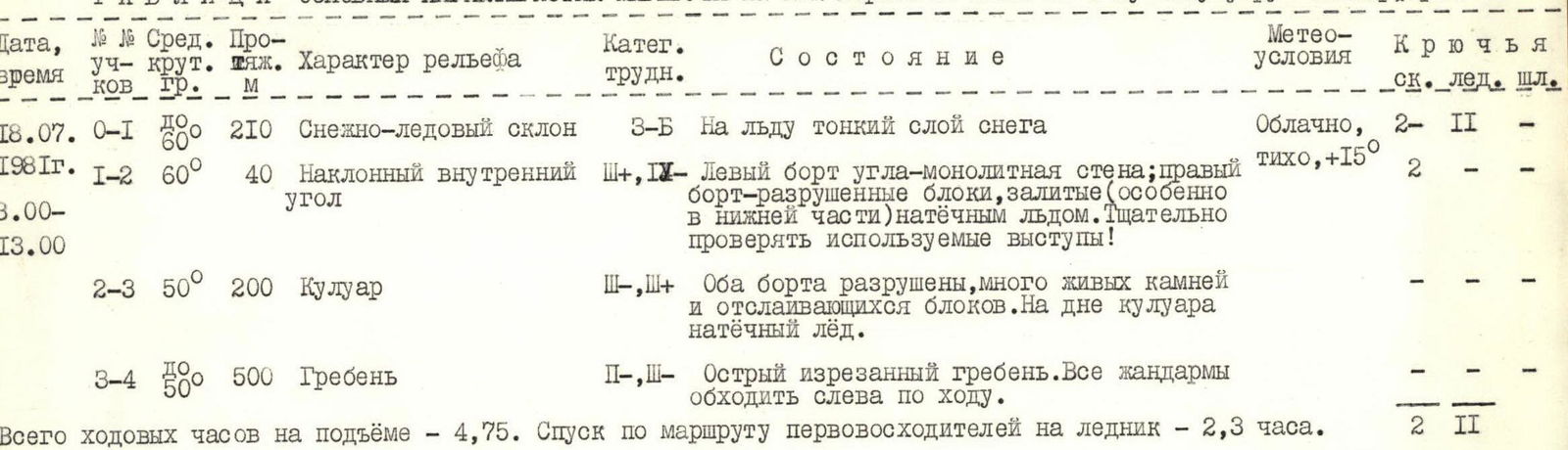
| Date, Time | Section | Avg. slope | Length, m | Terrain characteristics | Diff. cat. | Condition | Weather conditions | Pits (rock / ice / bolt) |
|---|---|---|---|---|---|---|---|---|
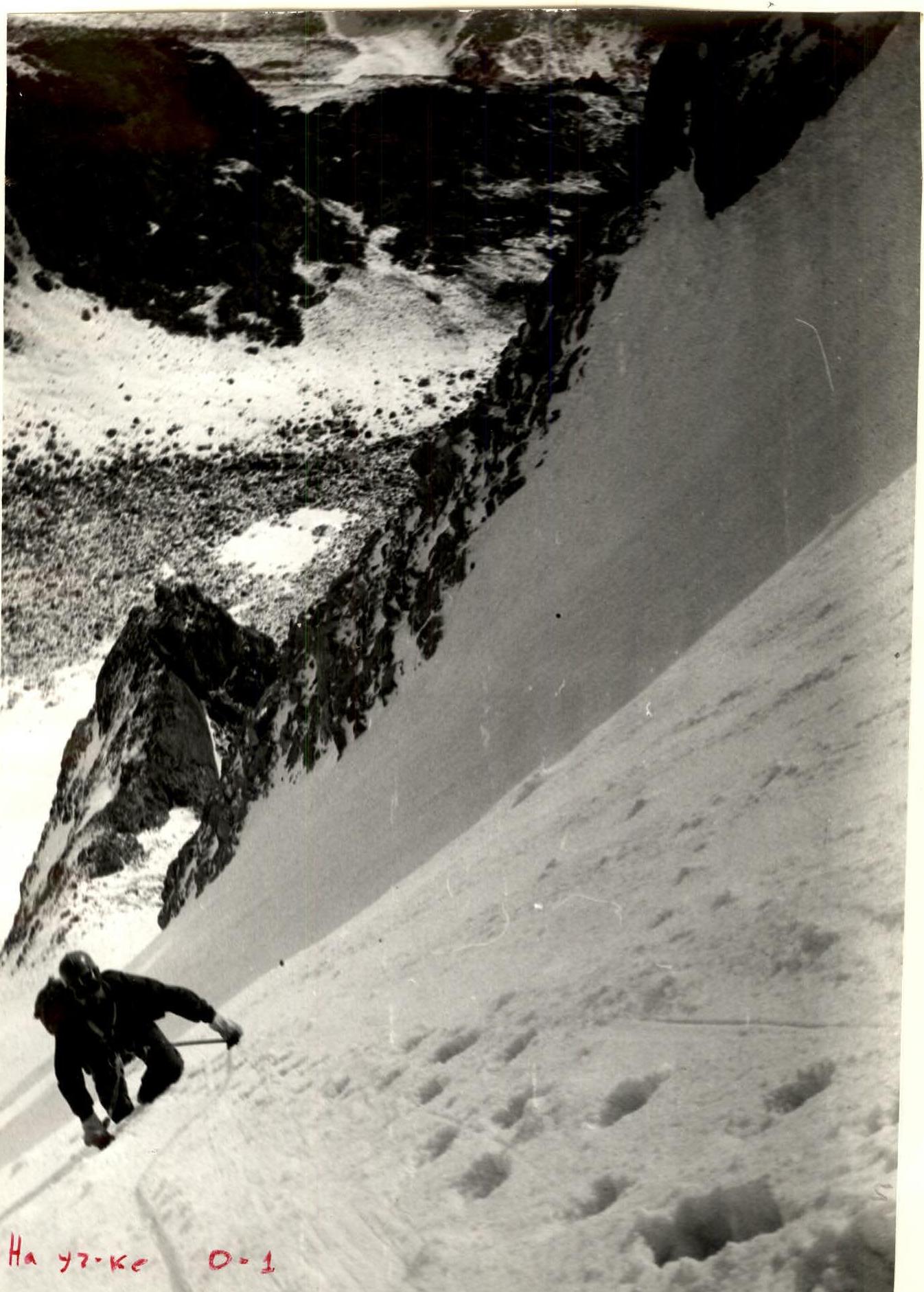
| 18.07.1981 | 0–1 | 60° | 200–210 | Snow-ice slope | 3 | Thin layer of snow on ice | Cloudy | 2 / 2 / none |
| 3:00–13:00 | 1–2 | 60° | 40 | Inclined inner corner | 3, 4 | Left side — monolithic wall; right side — broken blocks, covered with ice (especially in the lower part). Carefully check used ledges! | Calm, +15° | 2 / none / none |
| 2–3 | 50° | 200 | Couloir | 3 | Both sides are broken, many loose rocks and detaching blocks. Ice on the couloir floor. | none / none / none | ||
| 3–4 | 50° | 500 | Ridge | 2, 3 | Sharp jagged ridge. All pinnacles are bypassed on the left. | none / none / none |
Total climbing hours for ascent — 4 h 45 min. Descent via the route of the first ascenders to the glacier — 2 h 30 min.
CLASSIFICATION PROPOSALS
The exhausting approach to the start of the route through moraine ascents between Karatash and peak LVO is very similar to the ascent to the “Ratsek stand” and further transition to peak Semenov-Tian-Shansky in “Ala-Archa”. The 3A category route to peak Semenov-Tian-Shansky or to peak Skryabin is simpler than the described one. It is not weaker than 3A on Gadil, but inferior to such classic 3B routes as:
- Chokan Valikhanov;
- Western Shkhelda via V. D. Lubents;
- or via peak Profsoyuzov. Therefore, we propose to include the route we completed in the Classification Table as:
Ruchyeva B. peak 4555 3A combined via the 1st N. couloir of the E. spur Approach: to the Isk. Naukatsky forestry ~ 100 km from Osh.
On section 0–1