I. Climbing Passport
- Climbing category — rock climbing
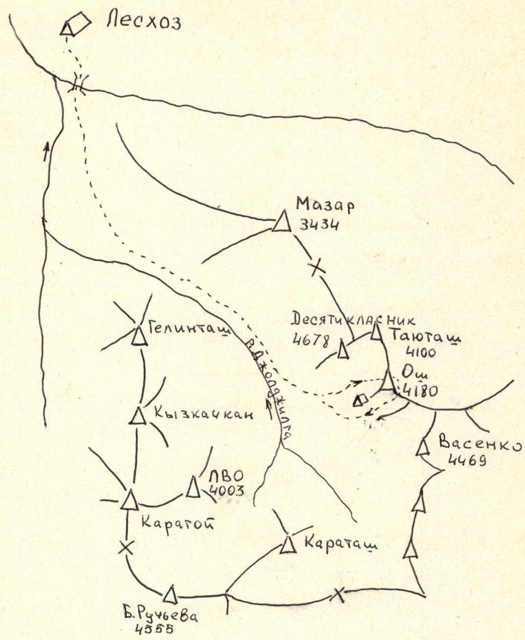
- Climbing area — Pamir-Alay, Alay ridge, Joldjilga valley
- Peak, its height, ascent route — peak Osh, 4180 m, via the center of the West wall.
- Proposed difficulty category — 5B
- Route characteristics: height difference — 490 m, length of sections with 5–6 difficulty category — 280 m, average steepness — 73°
- Number of pitons installed:
for belaying:
- rock pitons — 60
- bolt pitons — 0
- chocks — 20
for creating artificial climbing holds (ITCH):
- rock pitons — 26
- bolt pitons — 14
- chocks — 30
- Number of climbing hours — 28
- Number of nights and their characteristics — on moraine, after 3 ropes on a ledge — 2, 3, 4
- Surname, name, patronymic of the leader, participants and their qualification:
leader: M.I. Bashmakov — Candidate for Master of Sports
participants:
- Yu.V. Konovalov — 1st sports category
- Yu.V. Dudchenko — 1st sports category
- V.P. Moroz — 1st sports category
- S.G. Golubtsov — 1st sports category
- Team coach: L.A. Troshchinenko, Honored Master of Sports of the USSR
- Date of departure and return — 04.02.1983 – 08.02.1983
II. Climbs Area Map-Scheme

III. Peak Osh. Center of the West wall
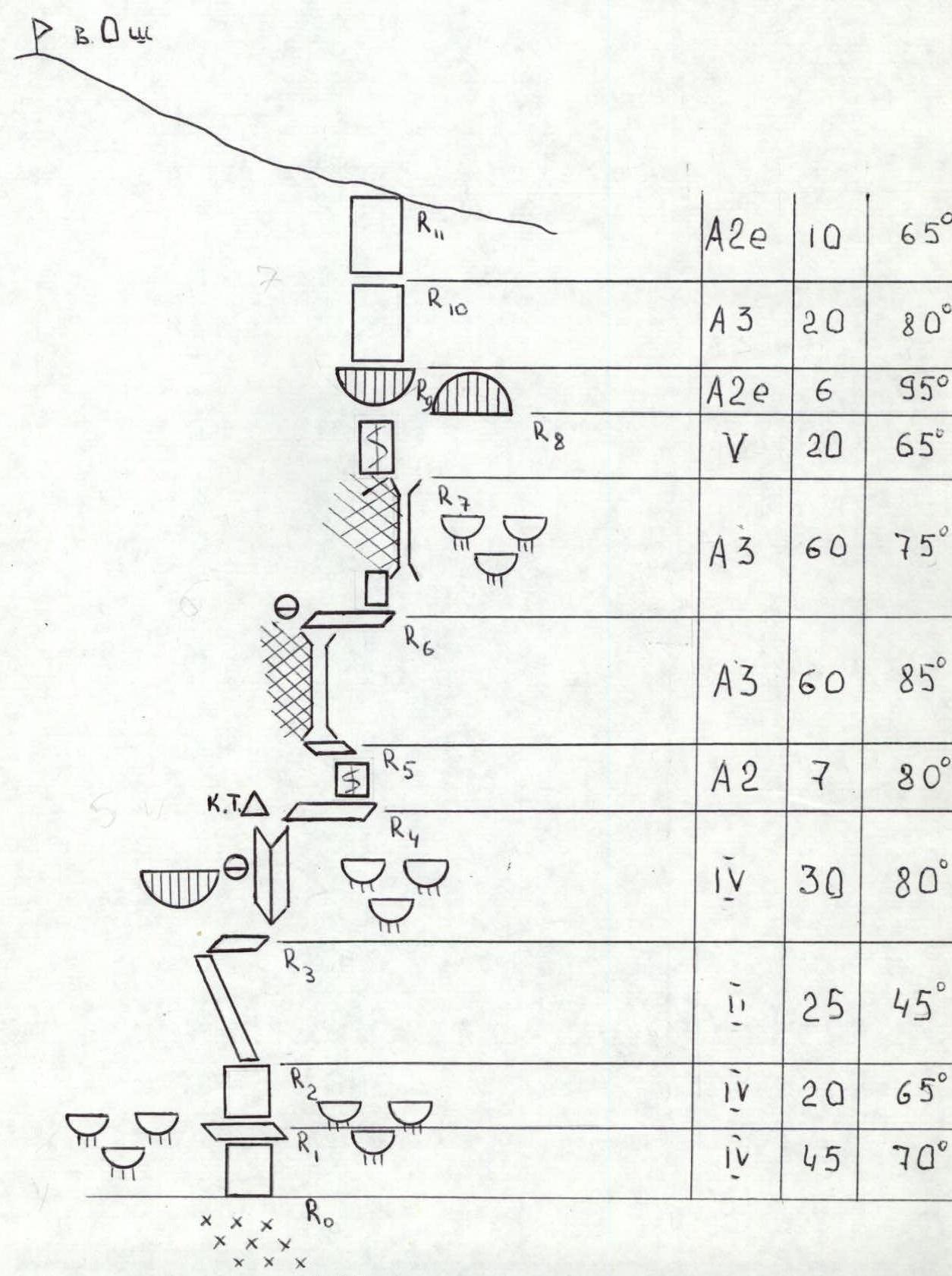
IV. Table of Main Characteristics of the Ascent Route
| Date | Section | Steepness (degrees) | Length (m) | Terrain characteristics | Difficulty | Condition | Rock pitons | Chocks | Bolt pitons |
|---|---|---|---|---|---|---|---|---|---|
| 04.02.1983 | R0–R1 | 70 | 45 | wall (forehead) | 5 | rock monolith, good | 16 | 5 | – |
| R1–R2 | 65 | 20 | wall (forehead) | 5 | rock monolith | 5 | – | – | |
| R2–R3 | 45 | 25 | ledge | 3 | rock monolith | 2 | 4 | – | |
| R3–R4 | 80 | 30 | inner corner | 4 | ice-covered rocks, good | 7 | 10 | – | |
| R4–R5 | 80 | 7 | wall | 5 | rock monolith, good | 3 | 2 | – | |
| R5–R6 | 85 | 40 | chimney | 6 | left part is destroyed, good | 12 | 8 | – | |
| R6–R7 | 75 | 60 | chimney | 5–6 | monolith, good | 23 | 12 | – | |
| R7–R8 | 65 | 20 | wall | 5 | rock monolith, good | 4 | 5 | – | |
| R8–R9 | 95 | 6 | wall | 6 | rock monolith, good | – | – | 4 | |
| R9–R10 | 80 | 20 | wall | 5 | rock monolith, good | 6 | 3 | – | |
| R10–R11 | 65 | 10 | wall | 5 | rock monolith, good | 2 | 4 | 10 | |
| 86 | 51 | 14 |
V. Brief Explanation for the Table of Main Characteristics of the Ascent Route
Section R0–R1: 45 m wall. "Crimea" type rock. This and the following section are prone to rockfall.
Section R1–R2: 20 m wall. "Sheep's foreheads" on the right and left. Snow and ice in places.
Section R2–R3: traverse right-up along a poorly defined ledge with small holds to a snow patch, then right to an inner corner.
Section R3–R4: ice-filled inner corner. The corner ends with a ledge going to the right. Control cairn.
Section R4–R5: small 7 m wall. Difficult climbing with an exit to a small sloping ledge.
Section R5–R6: a "reddish" chimney with an overhanging left side begins from the ledge. The chimney leads to a ledge.
Section R6–R7: traverse along the ledge to the right for 10 m. Then up the wall, which leads into a chimney ending with a small ledge.
Section R7–R8: a 20 m wall begins from the ledge, approaching a wall with characteristic black streaks. Ends with a long transverse crack.
Section R8–R9: overhanging section. Climbed using bolt pitons.
Section R9–R10: the overhang ends. There are smoothed ledges.
Section R11–R12: climb straight up along them. Climbing is very difficult. This and the following section are climbed using bolt pitons and "sky hook".
VI. Schematic Representation of the Wall Climbing Route according to UIAA