Report on the ascent of the Chelyabinsk Region Alpine Club group to the summit of Mazar (3434 m) (traverse along the NW ridge of the NW and Main peaks)
Magnitogorsk 2009
Climbing Passport
- Type of ascent: rock climbing.
- Region: 5.1.4. Pamir-Alay, Kichik-Alay range, Kirgiz-ata valley.
- Peak: Mazar (3434 m)
- Ascent route: traverse along the NW ridge of the NW and Main peaks
- Difficulty category: first ascent, proposed 3B
- Route characteristics: — rock climbing
Height difference — 670 m; Route length — 1210 m; Including:
- length of sections with 3rd difficulty category — 570 m;
- length of sections with 4th difficulty category — 120 m;
- average steepness — 40°, including wall sections — 54°
- Number of pitons: rock pitons — 18;
chocks — 54; slings — 49
- Number of climbing hours — 6 h 30 min.
Climbing days — 1 day.
- Departure to the route: July 30, 2009, 8:00 a.m.
Summit reached: July 30, 2009, 2:30 p.m. Return to base camp: July 30, 2009, 6:00 p.m.
- Group of the Chelyabinsk Region Alpine Club.
Leader: Igolkin Viktor Ivanovich, Master of Sports, Magnitogorsk; Participants:
- Markelov Vladislav Valer'evich, 3rd sports category, Magnitogorsk;
- Makarova Ekaterina Gennad'evna, 3rd sports category, Magnitogorsk;
- Kalmykov Konstantin Igorevich, 3rd sports category, Zlatoust;
- Group coach: Igolein Viktor Ivanovich, Master of Sports, instructor 1st category.
Brief Overview of the Climbing Region.
To the east of the Alay range, parallel to it, stretches the Kichik-Alay range for 80 km from east to west. The first alpinist peak to the northeast is Shankol (4630 m). The Kichik-Alay range extends southward, including peaks:
- Jalan-Kanysh (4426 m)
- Kumbel
- Pervomayskaya
- Surtoo
and beyond the pass of the same name — the beautiful Kurgan massif. Further, the range turns to the southwest and includes the wide massif of Djel'djip'ga (4545 m) with its northern Osh spur. South of the confluence of the Djel'djip'ga and Suu-chik'ty rivers — the base camp.
To reach the area from Osh, follow the highway west towards Kyzyl-Kiya for 40 km to the settlement Shakn-Nookat. Here, turn off the highway to the south. Past the former Tel'man collective farm, turn right onto the road on the right bank (orographic) of the Kirgiz-ata river, then onto the left bank, up the valley to the confluence of the Kara-goy and Kurgan rivers, forming the Kirgiz-ata river. Here, cross the Kirgiz-ata river to the left bank via a bridge, and continue up the road on the right bank (orographic) of the Kurgan river. 3.5 km above the forestry station, cross the Kurgan river via a bridge, and continue up the dirt road to the fork in the Djol'djip'ga and Kurgan valleys — turn right, across a bridge located near the lower camp in the Kurgan valley. From here to the base camp under the western slopes of peak Mazar — 1 h 30 min walking.
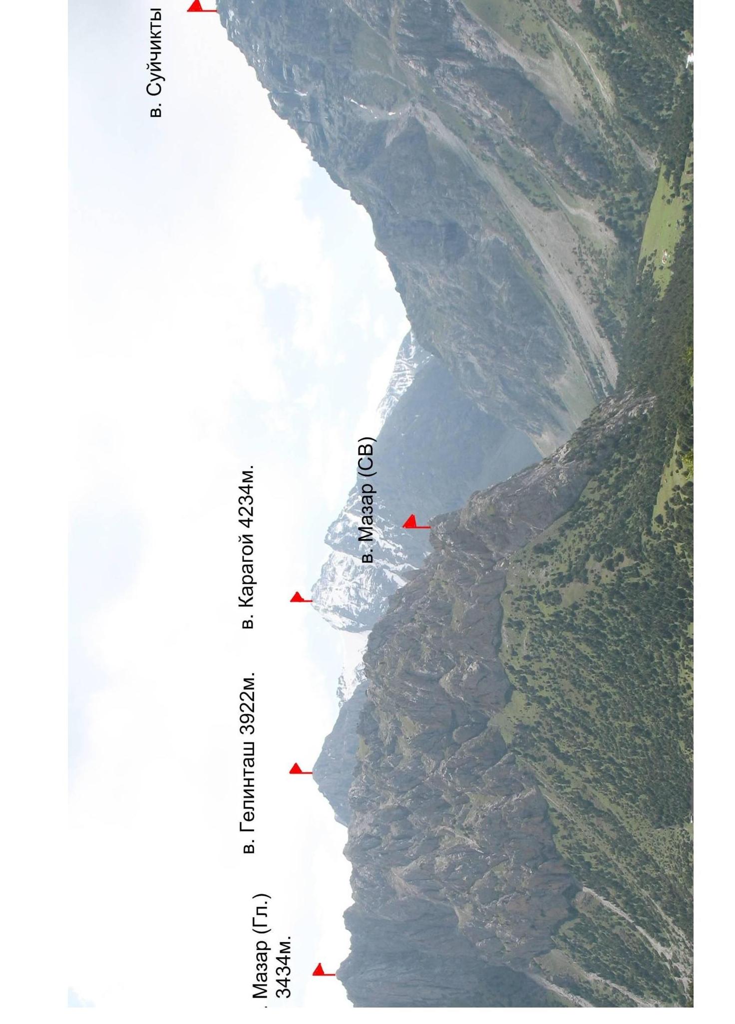
The Main peak Mazar is the most famous in the region. It is considered sacred by the local residents, not only in the Kirgiz-ata valley settlements but also in the valley's populated areas.
A relatively easy route from the southeast, not exceeding 1B difficulty category, has made it a pilgrimage site for thousands of believers and others.
Interestingly, its location is in the center between the Kurgan and Djal'djip'ga valleys, forming a common wide valley on the southern slopes of the peak.
From the road and forestry station, the peak appears as a powerful rocky pyramid, dominating the valley. This is the northwest peak, connected to the main peak by a long, approximately 1.5–2 km, rocky ridge with sheer walls on both sides.
The steep northwest ridge leading to the peak and the interesting rock outcrops of the main ridge were the goal of our first ascent.
There are no routes on the peak in the classification, although A.F. Naumov mentions an ascent with a "2" rating to the main peak from the south.
The climate in the Kirgiz-ata valley is moderately continental, with regular afternoon rains, sometimes turning to snow or hail. The daytime temperature in the base camp was between +15–+17°C, and nighttime between +7–+10°C.
Tactical Actions of the Group.
After observing and filming the peak from different angles and locations in the valley, its opposite slopes, and the Gelin'tash peak, we chose a route along the NW counterforce to the NW peak, followed by a traverse of the entire ridge to the Main (South) peak.
We worked in two independent pairs: Kalmykov — Markelov and Pogol'ni — Makarova. We coordinated our actions using left-behind chocks and pitons. We used ropes on key sections. The first climbers in the rope teams constantly changed positions. The key sections were predominantly climbed by the first rope team.
The group departed from the base camp at 7:30 a.m. The approach took 30 minutes. We started working on the route at 8:15 a.m. The entire route was completed in 6 h 30 min, and we returned to camp at 6:00 p.m.
Map of the Kyrgyz-Ata valley (Kichik-Alay range) scale 1:50 000
| peak Mazar (GA) 3434 m. | ||||||
|---|---|---|---|---|---|---|
| 12 | 34 | 49 | R13 | 1210 | ||
| . | 6 | 4 | R14 | 3A | 80 | |
| 5 | 5 | R13 | 25 | 200 | ||
| . | 4 | 4 | R12 | 3A | 110 | 40 |
| :--: | :--: | :--: | :--: | :--: | :--: | :--: |
| . | 1 | 3 | 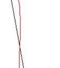 | 2A | 150 | 25 |
| . | 3 | 4 | 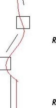 | 3A | 70 | 35 |
| . | 2 | 4 | 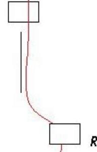 | 2E | 100 | 30 |
| 2 | 7 | 4 |  | 3E | 150 | 40 |
| :-- | :-- | :-- | :-- | :-- | :-- | :-- |
| 1 | R7 | 2A | 40 | |||
| 2 | R6 | 2E | 20 | |||
| 3 | 3 | 1 | R5 | 4E | 20 | |
| 3 | 4 | 3A | 50 | |||
| 7 | 11 | 4 | R3 | 4E | 70 | |
| 1 | 1 | R2 | 2E | 10 | ||
| 3 | 4 | 2 | 4A | 30 | ||
| 3 | 7 | 4 | R0 | 3A | 110 | |
| pitons | chocks | slings | Route in UIAA M 1:2000 symbols (1 cm — 20 m) | Section H | Cat. sl. 4 | Length m. | Steepness | Note |
|---|
Description of the Route by Sections.
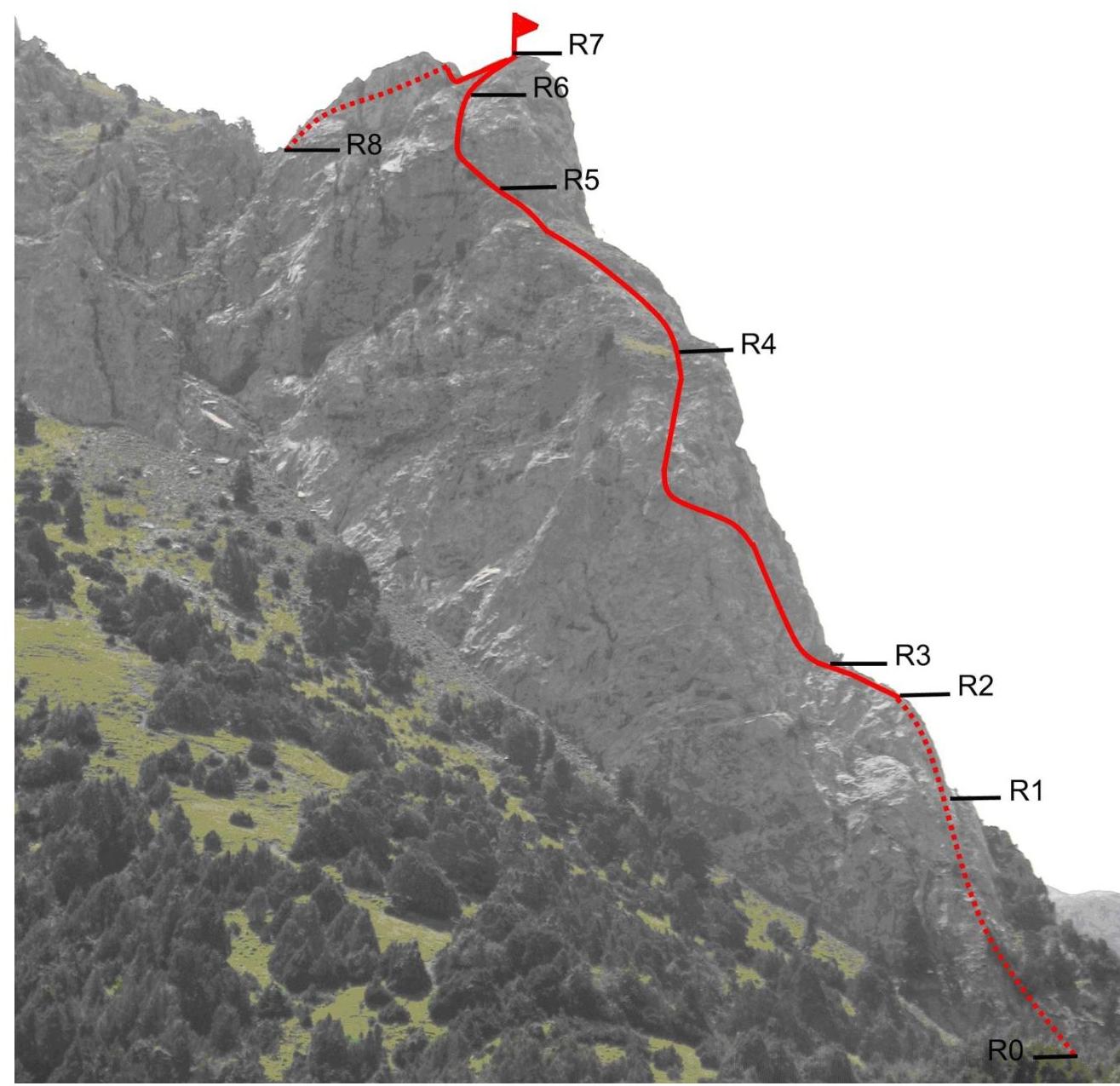
R0–R1 — The group's route follows a pronounced NW ridge. The section is 110 m long at an angle of 60°. The rock character is heavily destroyed.
R1–R2 — The section is 30 m long at an angle of 70°.
R2–R3 — The section follows a counterfort that steeply rises and turns obliquely to the left for 5 m. Organizing protection is challenging due to narrow slits; protection was achieved using chocks.
R3–R4 — The section is 70 m long at an angle of 70° with heavily destroyed relief.
R4–R5 — The wall passes to the left of the pre-summit "genie" along a sheer wall and approaches a sheer couloir.
R5–R6 — The sheer couloir with a "cork" in the middle serves as a cornice. The rock is raw with raw moss. Protection was achieved using large chocks. To the left of the couloir is a smooth and overhanging wall; the "cork" is bypassed to the left of the couloir.
R6–R7 — Not very steep pre-summit rocks with good relief lead to the NW peak. A cairn was erected on the peak. From the peak, a descent follows to a saddle.
R7–R8 — The ridge has steep, sheer slopes; the route goes to the right of the ridge. The relief is steep, destroyed, with good ledges for climbing; at the end of the section — a return to the ridge.
R8–R9 — Movement along the ridge with steep, sheer walls, with good ledges for protection.
R9–R10 — A not very steep, not very wide rocky ridge with small rocky ascents; simultaneous protection.
R10–R11 — The ridge is bypassed to the left along ledges along a sheer wall, with short but steep couloirs.
R11–R12 — A wide, not steep ridge; movement is simultaneous.
R12–R13 — A sharp ridge is traversed to the right along steep internal angles and walls. Loose rocks; movement follows steep rocky drops with variable protection.
R13–R14 — A long pre-summit rocky ridge.
R14–R15 — The ascent to the peak follows various internal angles, walls, and ledges.
Note: This peak is considered a sacred site by local residents; poles with tied fabric strips are fixed on the summit. Out of respect for local customs and delicacy towards this sacred site, we refrained from erecting a control cairn and leaving a note. A photo from the summit is attached to the report's photo illustrations.
The descent from the peak followed a steep but well-trodden trail to the southeast — to the pass between peak Gelin'tash and peak Mazar.
R1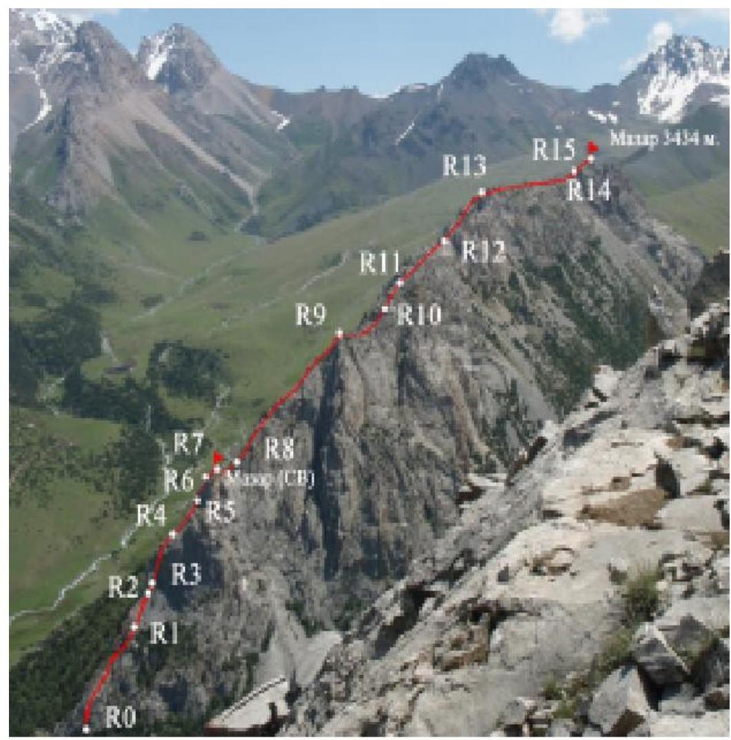
R15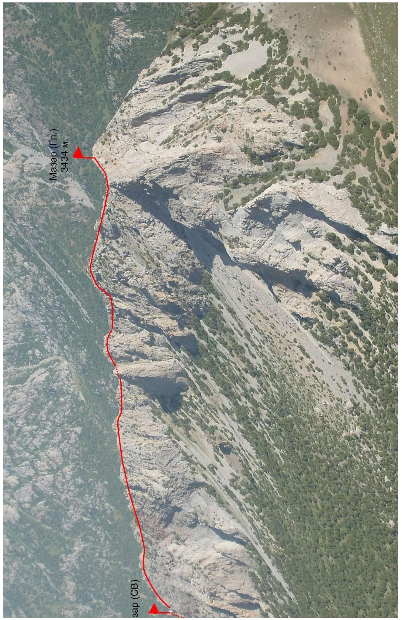
Mazar (Main) 3434 m


