50
Category of Technically Difficult Climbs
Khud Alay Range
(Kichik-Alay Ridge)
Peak "4003" (LVO Peak). First ascent via the northeast wall, category 5B (approximately) from July 27 to 31, 1974.
LVO Mixed Climbing Team:
- A.V. Gaas, CMS, - team leader
- O.V. Khudyakov, IMS, - coach
- S.A. Fedorov, CMS, - participant
- Yu.P. Gavrikov, MS, - participant
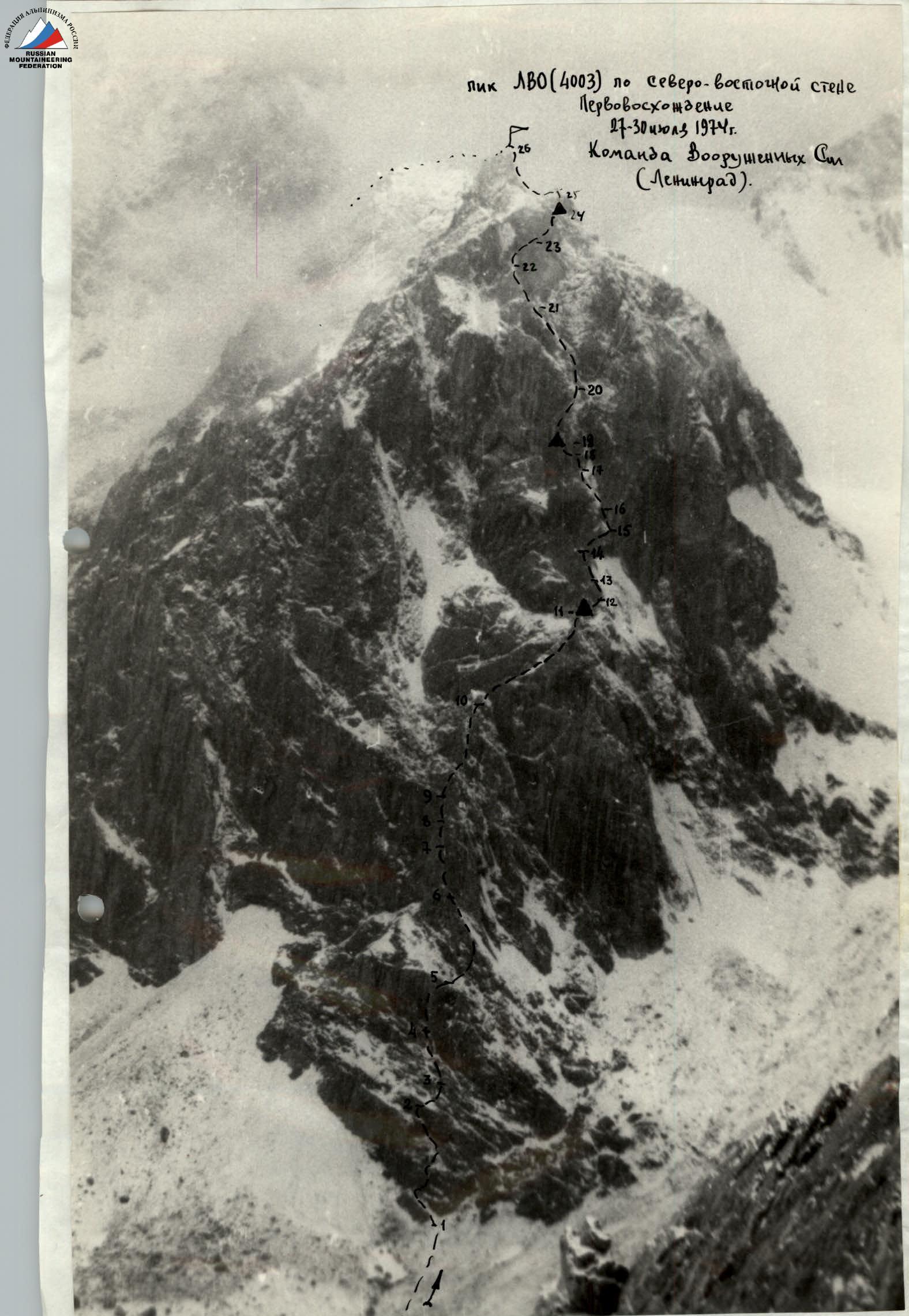
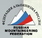
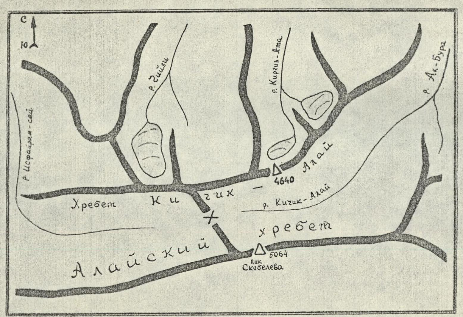
Fig. 1. Approximate diagram of the Khudyu-Anay three-thousander
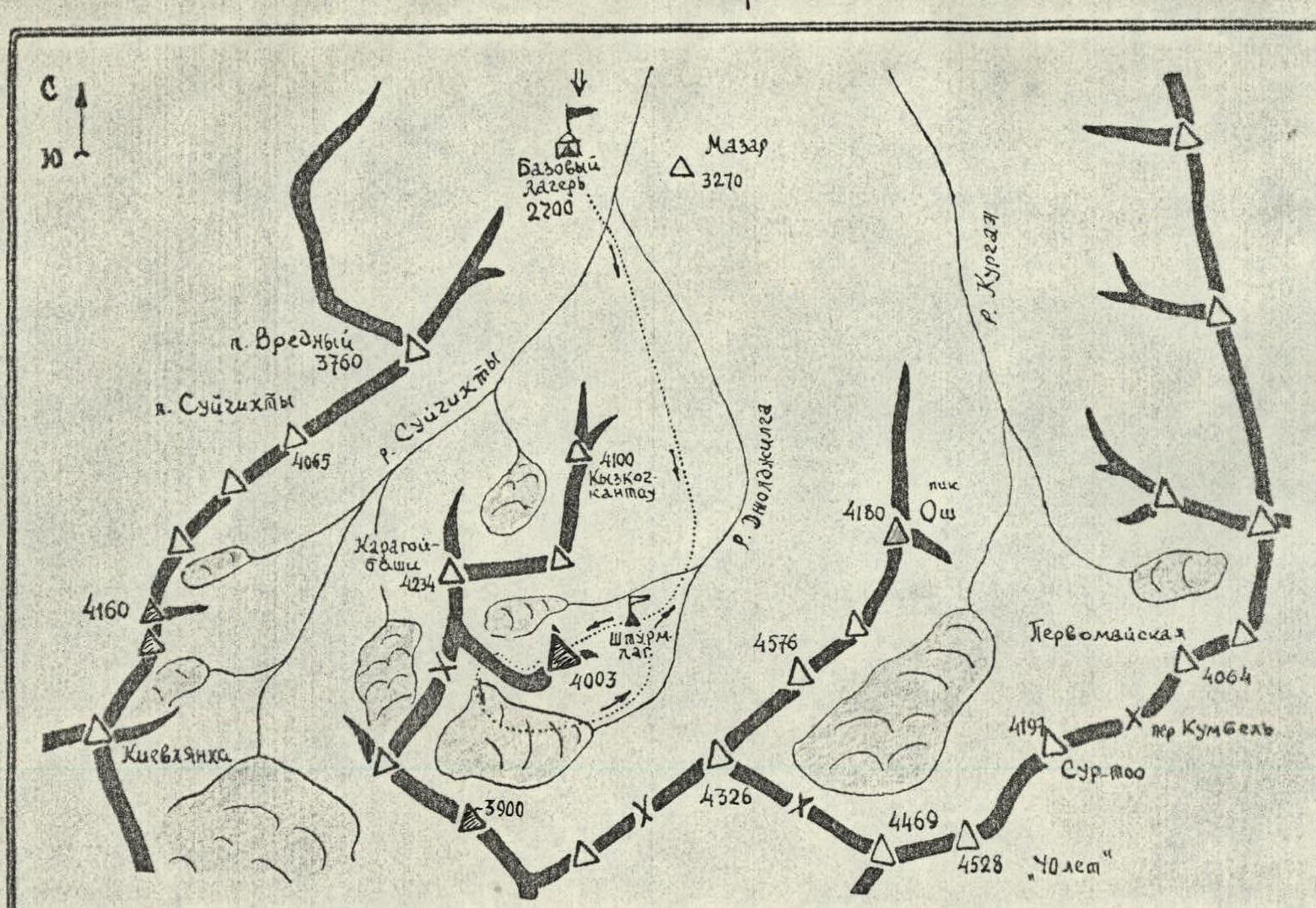
Fig. 2. Map of the ascent area
Several routes can be laid to the summit. The easiest path to the summit leads along the western ridge (the team's descent route) - approximately category 4A.
The most challenging routes appear to be:
- northeast wall - category 5A
- east wall - category 5A
- southeast wall - category 5A
The east and southeast walls are more destroyed and therefore more prone to rockfall.
The summit is composed of marbleized limestones. The route is combined - predominantly rocky. There are sections of snow and ice that remain on the route all year round due to the wall being mostly in the shade.
II. Climbing Conditions in the Area
A) Relief. A characteristic feature of Peak "4003" and its adjacent peaks is the blocky structure of the rocks. Some of these blocks - slabs - have very few holds and cracks.
The route has a fairly high steepness - about 60 ° and is characterized by a diverse relief - slabs, internal corners, chimneys, etc. There are few places on the route suitable for tent platforms (no more than 2-3).
B) Weather. The weather in Kichik-Alay is unstable even in the summer months. Heavy precipitation often falls, sometimes with thunderstorms. Fogs are often observed in the high-altitude zone. During the Armed Forces gathering and directly during the ascent, the weather was unstable. In the night and morning hours, it was frosty and mostly clear. From 12:00 to 13:00, the sky was covered with clouds, sometimes rain fell below, and snow or graupel fell above.
C) Exploration of the area. Despite the relative proximity of the area to Osh, from where many climbing expeditions begin their journey, the Kichik-Alay area is insufficiently studied and little developed in terms of mountaineering. This required several reconnaissance trips to the areas of the Suychykty and Joldhylga river gorges to choose the object of ascent.
III. Reconnaissance Trips
After the object of ascent - Peak "4003" - was chosen by the team, several additional reconnaissance trips were required to:
- clarify the ascent route,
- choose possible descent paths,
- observe the route and assess its safety,
- identify possible bivouac sites on the wall,
- clarify the list and set of necessary special equipment for the route.
Before the ascent, three such reconnaissance trips were made (July 20, 22-23, and 25, 1974).
As a result, the team finally settled on the route up Peak "4003" via the northeast wall.
The relative height difference from the base of the wall to the summit is at least 800 m.
IV. Organizational and Tactical Ascent Plan
The LVO team's preparation for this ascent began long before it, in Leningrad. During the autumn-winter season of 1973-1974, joint training sessions were held regularly 3-4 times a week. The monthly running norm (to train physical endurance) was about 200 km, with:
- running on snow in winter,
- running on sand in spring.
They would often visit rocky areas (near Priozersk) to practice navigating steep sections and working in pairs.
Special equipment was designed and tested:
- a large set of titanium rock and ice pitons,
- down-filled climbing gear was sewn.
The organizational and tactical plan for passing the route to Peak "4003" via the northeast wall, developed in accordance with the actual state of the route, the recommendations of the team's coach and the coaching council, provided for:
- completing the route in 4 travel days,
- 2 reserve days for bad weather.
As a result of reconnaissance trips and observations of the route, it was established:
- The route is not heavily snowed. There are significant sections of wet rocks in the middle part of the route.
- The wall is lit by the sun only in the morning hours (from sunrise - around 7:00 to 10:00).
- The rockfall hazard of the route is not high. Traces of falling and spontaneous rockfall were noted to the left of the route (from the east and southeast walls).
- The height difference of the route is approximately 4. The steepness of the route is quite high, especially in the middle part of the wall.
- There are few places on the route for overnight stays. Only 1-2 possible tent platforms were observed.
- The weather is unstable. At night and in the morning, it is mostly clear and cool. In the second half of the day, it is cloudy, sometimes rainy, and thunderstorms occur below.
These circumstances were taken into account when drawing up the tactical plan for the ascent. It consisted of the team approaching the wall "on the move" without prior processing, since the beginning of the route was not as steep as the middle part of the wall.
It was planned that:
- in case of bad weather,
- before the most difficult sections, the team could switch to climbing the wall with preliminary rope installation from intermediate camps.
The descent from the summit was planned to be done along the western ridge.
The route passage confirmed the correctness of the main provisions of the tactical plan.
Throughout the ascent, stable radio communication with the observation group (led by O.G. Dotsenko) was maintained twice a day. Additionally, communication was duplicated with flares.
The composition of the rope teams changed during the ascent, allowing the group to constantly maintain a high level of performance. The task of the first team - the "twosome":
- processing and passing the route.
The second team, as a rule, was responsible for pulling up backpacks. The first team worked without backpacks and on a double rope.
V. Composition of the Assault Team
The first ascent of Peak "4003" was made by a team consisting of:
- A.V. Gaas - captain
- O.V. Khudyakov - coach
- S.A. Fedorov - participant
- Yu.P. Gavrikov - participant
All team members are prize-winners of various championships (in Leningrad).
VIII. Route Progression
July 27
At 5:00, the team left the base camp for the ascent. The weather is good. At 7:30, they approached the assault camp under the northeast wall of Peak "4003", from where they started the route at 8:00. Having passed 30 m along the talus slope (R0–R1), they reached the lower rocky belt (R1–R2). Its length is 2 ropes. It has individual vertical rocky walls 3-4 m high. They are passed by free climbing with pitons. The rocky belt leads to a talus ledge (R2–R3), along which they moved 10 m to the right and entered the lower part of the inclined internal corner, which is 30 m long (R3–R4). Above it is a 40-meter rocky wall with a steepness of 60 ° (R4–R5), which has 3 steep sections 4-5 m each. On this wall, there are two talus ledges with many "live" stones (1). Next is a rope of relatively easy rocks (R5–R6), and they reached the beginning of the internal corner with wet walls (R6–R7). In the middle part of the corner, there are sections of ice. It is climbed straight up. The internal corner ends in a chimney with a plug (R7–R8). The chimney is 50-60 cm wide and is overcome on jammed limbs, with backpacks being pulled up. After the chimney, there is a steep and difficult rocky wall (R8–R9) with few holds but good cracks for pitons. Above this wall is a convenient ledge where they set up a belay and pulled up the backpacks. Next is a very complex 50-meter steep rocky wall (R9–R10), which is intersected by an oblique crack filled with ice. They climbed up directly along the crack and reached the beginning of the inclined slabs. Along these slabs, they climbed 2 ropes, making maximum use of the friction of their Vibram boots. The slabs are dry, and in the middle part, they are intersected by an inclined talus ledge 1-1.5 m wide. The slabs lead to a ledge convenient for setting up a bivouac. Nearby is a small snowpatch. Here, they built a good platform for a reclined overnight stay and set up a control cairn. The first working day on the wall lasted 11 hours and 30 minutes. More than 50 rock pitons were hammered.
| Date | Passed Sections | Steepness of Section, ° | Length of Section, m | Character of Relief | Technical Difficulty | Method of Overcoming and Belaying | Weather | Stop for Bivouac | Travel Hours | Rock Pitons | Ice Pitons | Shoulder Pitons | Camping Conditions |
|---|---|---|---|---|---|---|---|---|---|---|---|---|---|
| July 27 | R0–R1 | 35 | Simple average talus | A wide talus slope leading to the base of the wall. | Simultaneous movement | Clear | — | 0 h 30 min | — | — | — | ||
| R1–R2 | 80 | Rocks of medium difficulty, местами сложные. | 1st rocky belt with individual 3–4 m walls having good holds. | Free climbing, alternating movement, piton belay. | Clear | — | 2 h 00 min | 10 | — | — | |||
| R2–R3 | Traverse right | 10 | Talus ledge | Talus ledge in the upper part of the 1st rocky belt. The ledge leads to an inclined internal corner. | Traversing along the ledge. Piton belay. | Clear | — | 0 h 30 min | 3 | — | — | ||
| R3–R4 | 70° | 30 | Complex rocks | Inclined internal corner with individual blocks. | First on a double rope. Free climbing. Piton belay. | Clear | — | 1 h 00 min | 5 | — | — | ||
| R4–R5 | 60° | 40 | Complex rocks | Inclined rocky wall with 3 steep sections 4–5 m each, separated by narrow talus ledges. There are "live" stones on the ledges. | Free climbing. Piton belay | Clear | — | 1 h 00 min | 6 | — | — | ||
| R5–R6 | 40° | 35 | Simple and medium difficulty rocks | Destroyed rocky wall. | Simultaneous movement. Piton and protrusion belay. | Clear | — | 0 h 30 min | 2 | — | — | ||
| R6–R7 | 60° | 40 | Complex rocks | Internal corner. Rocks are wet, with small ice sections. | Free climbing. Piton belay. | Clear | — | 1 h 00 min | 5 | — | — | ||
| R7–R8 | 90° | 8 | Extremely complex rocks | Chimney with a plug | Free climbing on jammed limbs. Piton belay. The first without a backpack, others on jumar along the rope. Pulling up backpacks. | Clear | — | 0 h 45 min | 3 | — | — | ||
| R8–R9 | 80–85° | 10 | Very complex rocks | Steep rocky wall with few holds but good cracks. | Free climbing. Piton belay. The first without a backpack on a double rope, others on perils on jumar. Pulling up backpacks. The wall leads to a convenient ledge for belaying. | Clear | — | 0 h 45 min | 3 | — | — | ||
| R9–R10 | 75° | 50 | Very complex rocks | Steep rocky wall. To the left is an overhanging wall with ice sections. The wall is intersected by a crack from right to left and upwards, partially filled with ice. | Free climbing. Piton belay. The first on a double rope, others on jumar. Pulling up backpacks. | Clear | — | 1 h 30 min | 7 | — | — | ||
| R10–R11 | 50–55° | 80 | Complex rocks | Inclined slabs with few holds. | Free climbing | Clear | 20:00 | 2 h 00 min | 11 | — | — | Reclined | |
| A control cairn was set up here. A platform for a reclined overnight stay was built. 8 rock pitons were hammered on the bivouac for tent securing and setting up perils. | |||||||||||||
| July 28 | R11–R12 | 45° | 10 | Simple rocks | Destroyed rocky wall leading to a ledge under wet slabs. | Free climbing. Simultaneous movement. Belay via protrusions and pitons. | Clear | 7:00 | 0 h 15 min | 1 | — | — | |
| R12–R13 | Traverse left | 10 | Complex rocks | Extensive ledge under wet inclined slabs. | Traversing along the ledge to the left. Piton belay. | Clear | — | 0 h 15 min | 2 | — | — | ||
| R13–R14 | 60–65° | 20 | Complex rocks | Inclined slab. | Free climbing using friction. Piton belay. Pulling up backpacks. | Clear | — | 1 h 00 min | 5 | — | — | ||
| R14–R15 | 75° | 30 | Very complex rocks | Wet inclined slab with small cracks suitable for thin pitons. | Free climbing with maximum use of friction. At the top, climbing using ladders. Piton belay. Pulling up backpacks. | Clear | — | 2 h 00 min | 8 | — | — | ||
| R15–R16 | 90° | 20 | Extremely complex rocks. | Chimney with wet walls, partially with ice plugs. | Climbing using artificial holds and on jammed limbs. | Clear | — | 1 h 30 min | 4 | — | — | ||
| R16–R17 | 45° | 50 | Snow on ice, very complex section. | Narrow (up to 3–4 m wide) steep couloir. Wet snow layer on an ice base. Steep wet rocky walls on the left and right. The couloir leads to a steep and wet rocky wall. | Step-cutting. Piton belay. | Mostly clear | — | 1 h 45 min | 2 | 5 | — | ||
| R17–R18 | 85° | 25 | Extremely complex rocks | Steep wet rocky wall (with a ledge in the middle). | Free climbing. Piton belay. Pulling up backpacks. | Mostly clear | — | 1 h 45 min | 5 | — | — | ||
| R18–R19 | 85° | 20 | Extremely complex rocks | Vertical internal corner with almost no holds and ledges facing downwards. | Climbing on jammed limbs. Used 2 ladders at the top. | Overcast | 17:30 | 2 h 00 min | 4 | — | — | Sitting | |
| A small platform for a sitting overnight stay was prepared here. A tent was hung on pitons under an overhanging wall on the left. 5 rock pitons were hammered on the bivouac. | |||||||||||||
| July 29 | R19–R20 | 60° | 60 | Complex rocks | Reddish rocky wall with small ledges suitable for belaying. Snow and ice on the ledges. | Free climbing. Piton belay. | Clear | 7:00 | 2 h 30 min | 8 | — | — | |
| R20–R21 | 70° | 80 | Very complex rocks | Oblique (left-upwards) internal corner turning into a chimney. Ice plugs in the chimney, water flowing down the walls. | Free climbing. The first without a backpack on a double rope, others on jumar along the perils. Pulling up backpacks. | Clear | — | 4 h 00 min | 14 | — | — | ||
| R21–R22 | 50–55° | 40 | Rocks of medium complexity | Rocky wall with a blocky structure. "Live" stones present. | Free climbing. Belay via protrusions and pitons. | Mostly clear, wind | — | 1 h 15 min | 7 | — | — | ||
| R22–R23 | Traverse right | 20 | Complex rocks | Wet rocky ledge, partially with ice. | Traversing along the ledge. Piton belay. | Overcast, wind | — | 0 h 45 min | 6 | — | — | ||
| R23–R24 | 75–80° | 40 | Very complex rocks | Dark steep rocky wall leading to a ledge up to 2–2.5 m wide. | Free climbing. At the top, climbing using artificial holds. Piton belay. Pulling up backpacks. | Overcast, light snow, wind | 18:30 | 3 h 00 min | 12 | — | — | ||
| A good platform for a reclined overnight stay was built on the ledge. 4 rock pitons were hammered on the bivouac for tent securing and setting up perils. | |||||||||||||
| July 30 | R24–R25 | 75–80° | 20 | Very complex rocks | Vertical rocky wall with few holds. The wall leads to the pre-summit ridge. | Free climbing. Piton belay. | Clear, wind | 7:00 | 1 h 30 min | 3 | — | — | |
| R25–R26 | 45° | 160 | Rocks of medium complexity | Narrow and sharp rocky ridge with two vertical walls 5–6 m high (with good holds and cracks for pitons). | Free climbing. Piton and protrusion belay, some sections passed without backpacks. | Clear | — | 4 h 00 min | 7 | — | — |
July 28
...with steep wet rocky walls on the left and right having almost no cracks. We pass the couloir with step-cutting and ice pitons.
Our trials on this day are not over with the passage of the couloir. Ahead is a 25-meter steep wet rocky wall (R17–R18), followed by a 20-meter vertical internal corner with almost no holds and ledges facing downwards (R18–R19). This is the third key point of the route, also familiar to us from the route reconnaissance. We pass the internal corner on jammed limbs, using ladders. We pull up the backpacks. We climb onto a small but convenient ledge under an overhanging wall. More convenient places for setting up a bivouac are not visible ahead. The time is 17:30. We have been working for over 10 hours. The weather is deteriorating. The sky is covered with clouds. We decide to stop for a bivouac. We manage to level out the platform but not expand it - the overnight stay in the tent is sitting.
July 29
We start the route at 7:00. The weather is good, although clouds are visible on the horizon and down the valley. Immediately from the overnight stay, a 60-meter reddish wall begins (R19–R20). We pass it straight "head-on". Above it, an inclined internal corner begins, turning into a chimney at the top. There are ice plugs in the chimney, and water flows down the walls. We pass this section without backpacks, which are then pulled up. The weather worsens again: the wind strengthens, and clouds gather. Above is a rocky wall with a steepness of 50–55°, having a blocky structure (R21–R22). The wall leads to a wet, partially icy, rocky ledge (R22–R23). Along this ledge, we move 20 m to the right to a dark, almost vertical rocky wall, leading to the pre-summit ridge.
July 30
The summit is reached on July 30 at 12:30. The wall is very complex - again, we have to use ladders. Having climbed this wall for 40 m (R23–R24), we reach a good ledge, up to 2.5 m wide, convenient for setting up a bivouac. The weather continues to deteriorate, and snow begins to fall. On this ledge, we lay out a good platform for a reclined overnight stay. Bivouac No. 3, altitude 3900 m.
We leave the bivouac at 7:00. The weather is good. From the overnight stay, we climb 20 m up a vertical rocky wall, leading to the pre-summit ridge (R24–R25). The pre-summit ridge is very narrow and sharp. We move along it for 160 m. We reach the summit at 12:30. There is no cairn. We are on the summit, where no one has been before. Everyone is very excited. We build a cairn and insert our note into it. We decide to name this unnamed peak - Peak LVO, in honor of the Lenin Order Leningrad Military District. We hurry down - the horizon is again covered with clouds.
From the summit, we descend first along the ridge to the west - 160 m, then set up 2 rappels of 40 m each. Further - 40 m along the talus ledges to the left of the "boulder" on the ridge, and we reach the saddle between Peak "4003" and the Karagoybashi peak. From the saddle, a snow-ice slope leads to the right, and a talus slope to the left. We go to the left. At 18:30, we are in the assault camp, where our observers meet us. Then we all go together to the base camp.
The descent from the summit to the assault camp under the wall took 6 hours of travel time.
IX. Evaluation of Participants' Actions
During the ascent, all team members proved themselves well, demonstrating high physical and technical preparation.
All participants took turns leading on various forms of rocky relief. This allowed for frequent changes of the leading "twosome".


