- Climbing type: rock
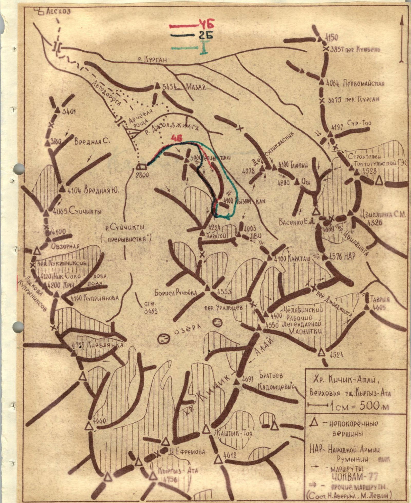
- Climbing area, Pamir-Alay range, Kichik-Alay ridge
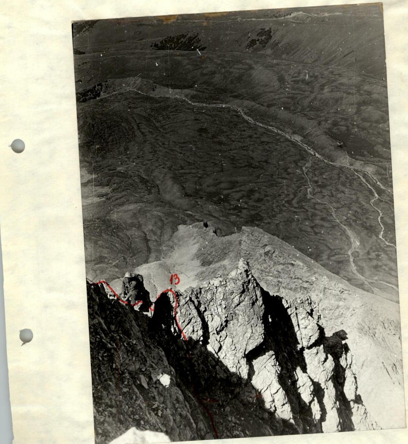
- Peak Kyzkochkan, height 4100 m (according to KTMGV), ascent route via the northern ridge
- Proposed category: 4B
- Route description: elevation gain 900 m, length of sections 5–6 km/tr, 280 m, average steepness 60°
- Pitons hammered: for belaying, for creating ITO. Rock pitons 67 (including 1 ice piton). Ice pitons —. Bolt pitons —.
- Total climbing hours 10.8 + 4 hours of preliminary reconnaissance and processing on 20.08.1977.
- Number of nights and their characteristics: one — in a tent on a constructed ledge. Safe, but no water.
- Team leader, participants, and their qualifications:
- Khramtsov V.A. 2nd sports category.
- Vyushkova V.P. 2nd sports category.
- Glyadelov V.S. 2nd sports category.
- Lensky S.V. 1st sports category.
- Team coach: Master of Sports Levin M.S.
- Date of departure and return: 02.09.1977—03.09.1977.
Signed: V. Khramtsov
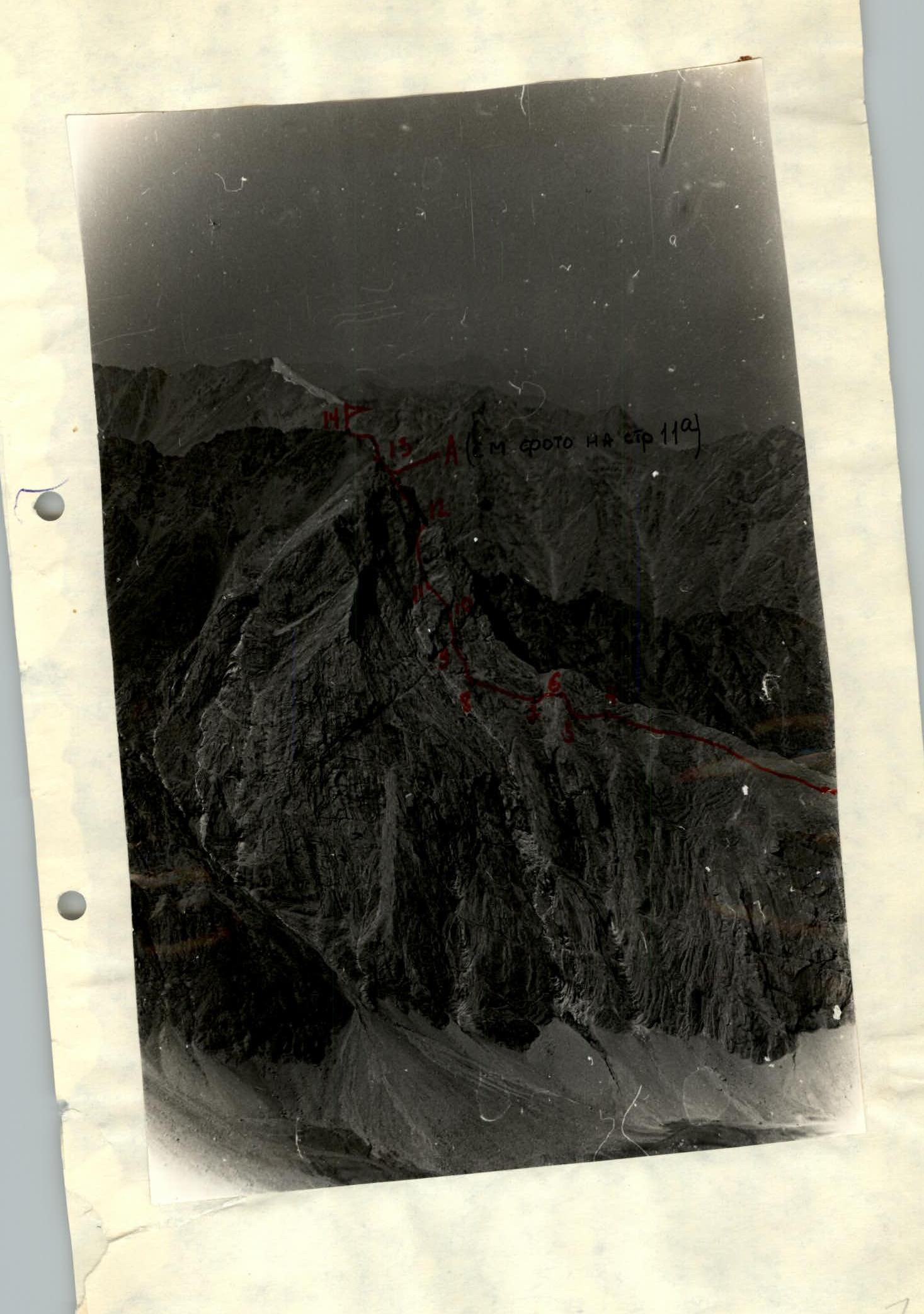
— The route of the TURKVO-68 group (led by A.D. Putintsev) — is a short 55, somehow classified as 4B via the eastern wall. — From the southern cirque, a 2A category route was laid by the CHOKVAM-78 group under the leadership of Yu. Samokotin — see the photo on the next page for more details. — The described route via the Northern ridge. — The route of the CHOKVAM-78 group (led by V. Evtov) via the Northern crest, 2B category.
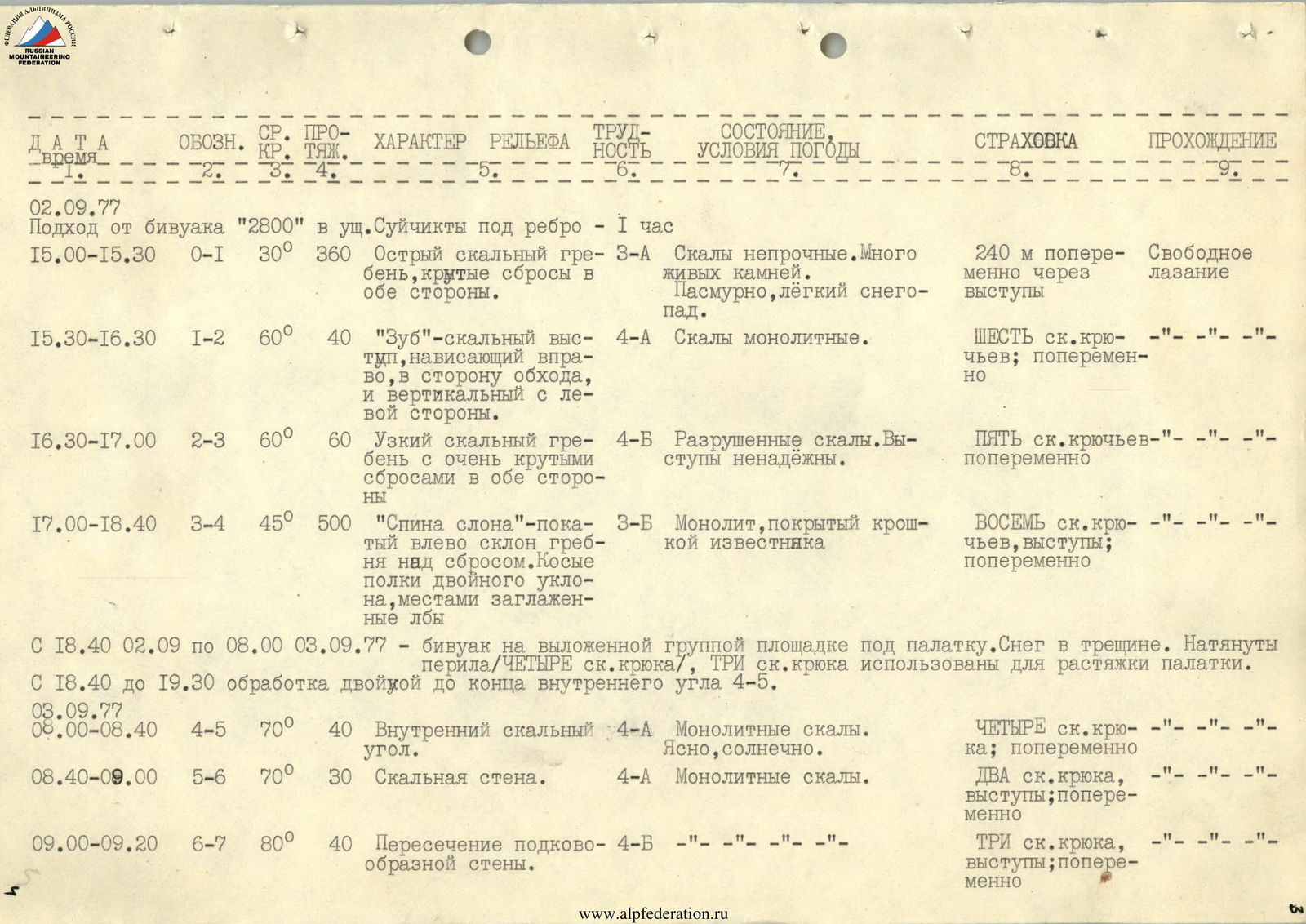
02 September 1977.
Approach from the "2800" bivouac in the Suichikty gorge to the ridge — 1 hour.
-
15:00–15:30 R0–R1 30° 360 m.
- Sharp rocky crest with steep drops on both sides. Category of difficulty: 3A.
- Rocks are unstable. Many loose stones. Overcast, light snowfall.
-
15:30–16:30 R1–R2 60° 40 m.
- "Tooth" — a rocky outcrop overhanging to the right, towards the bypass, and vertical on the left side. Category of difficulty: 4A.
- Rocks are monolithic.
-
16:30–17:00 R2–R3 60° 60 m.
- Narrow rocky ridge with very steep drops on both sides. Category of difficulty: 4B.
-
17:00–18:40 R3–R4 45° 500 m.
- "Elephant's back" — a slope inclined to the left above the drop. Oblique shelves with double slope, местами заглаженные лбы. Category of difficulty: 3B.
- Monolith covered with limestone crumb.
-
From 18:40 on 02 September 1977 to 8:00 on 03 September 1977.
- Bivouac on a site prepared by the group for the tent.
- Snow in the crevice.
- Ropes stretched (four rock pitons), three rock pitons used for tent anchoring.
- From 18:40 to 19:30, processing of the double pitch to the end of the internal corner R4–R5.
03 September 1977.
-
8:00–8:40 R4–R5 70° 40 m.
- Internal rocky corner. Category of difficulty: 4A.
- Monolithic rocks. Clear, sunny.
-
8:40–9:00 R5–R6 70° 30 m.
- Rocky wall. Category of difficulty: 4A.
- Four rock pitons; alternating. Two rock pitons, outcrops; alternating.
-
9:00–9:20 R6–R7 80° 40 m.
- Crossing of a horseshoe-shaped wall. Category of difficulty: 4B.
- Three rock pitons, outcrops; alternating.
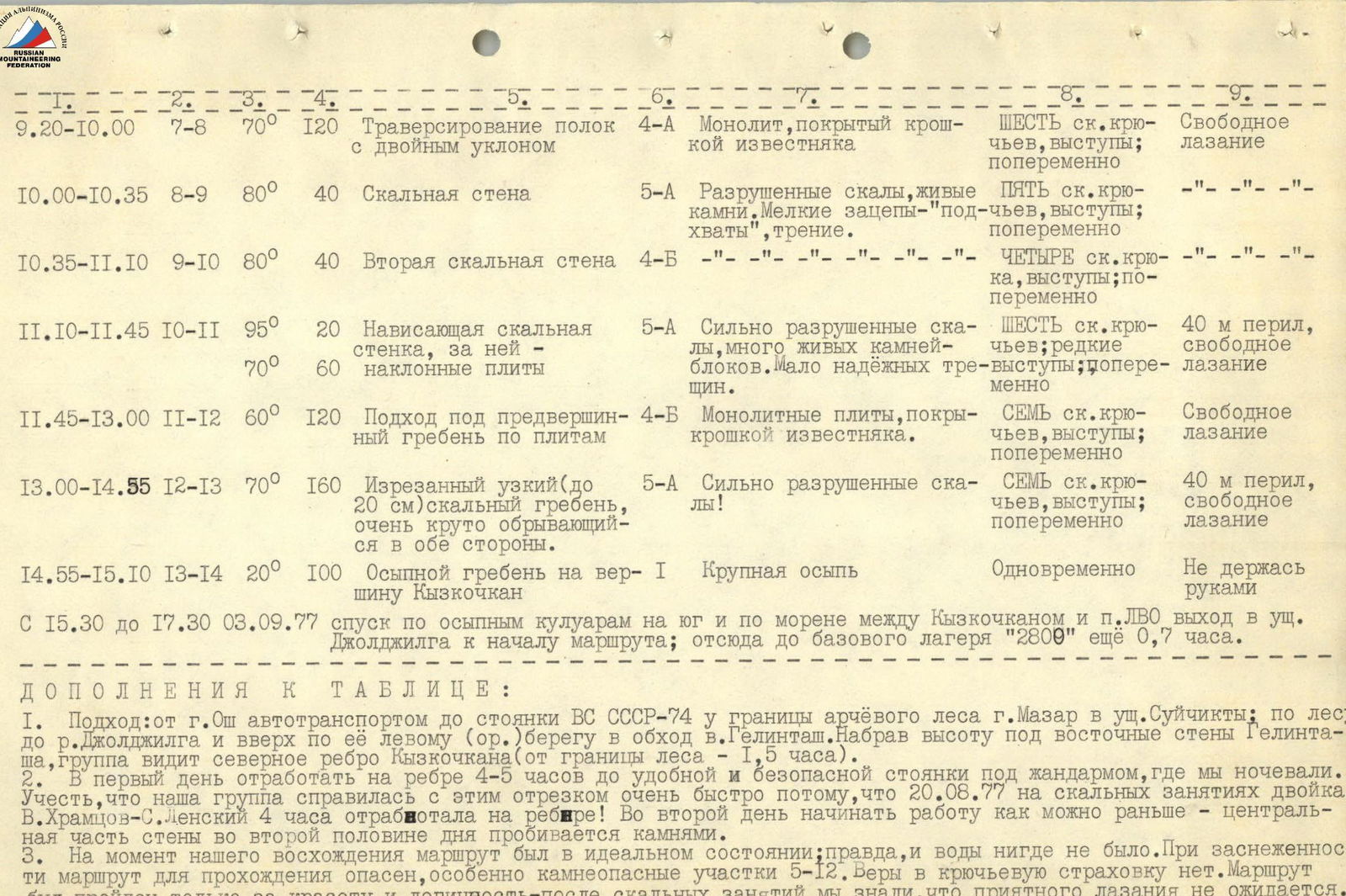
9:20–10:00 R7–R8
 Traversing shelves with double slope. Category of difficulty: 4A. Monolith covered with limestone crumb. Belaying: Six rock pitons, outcrops; alternating. Climbing: Free climbing.
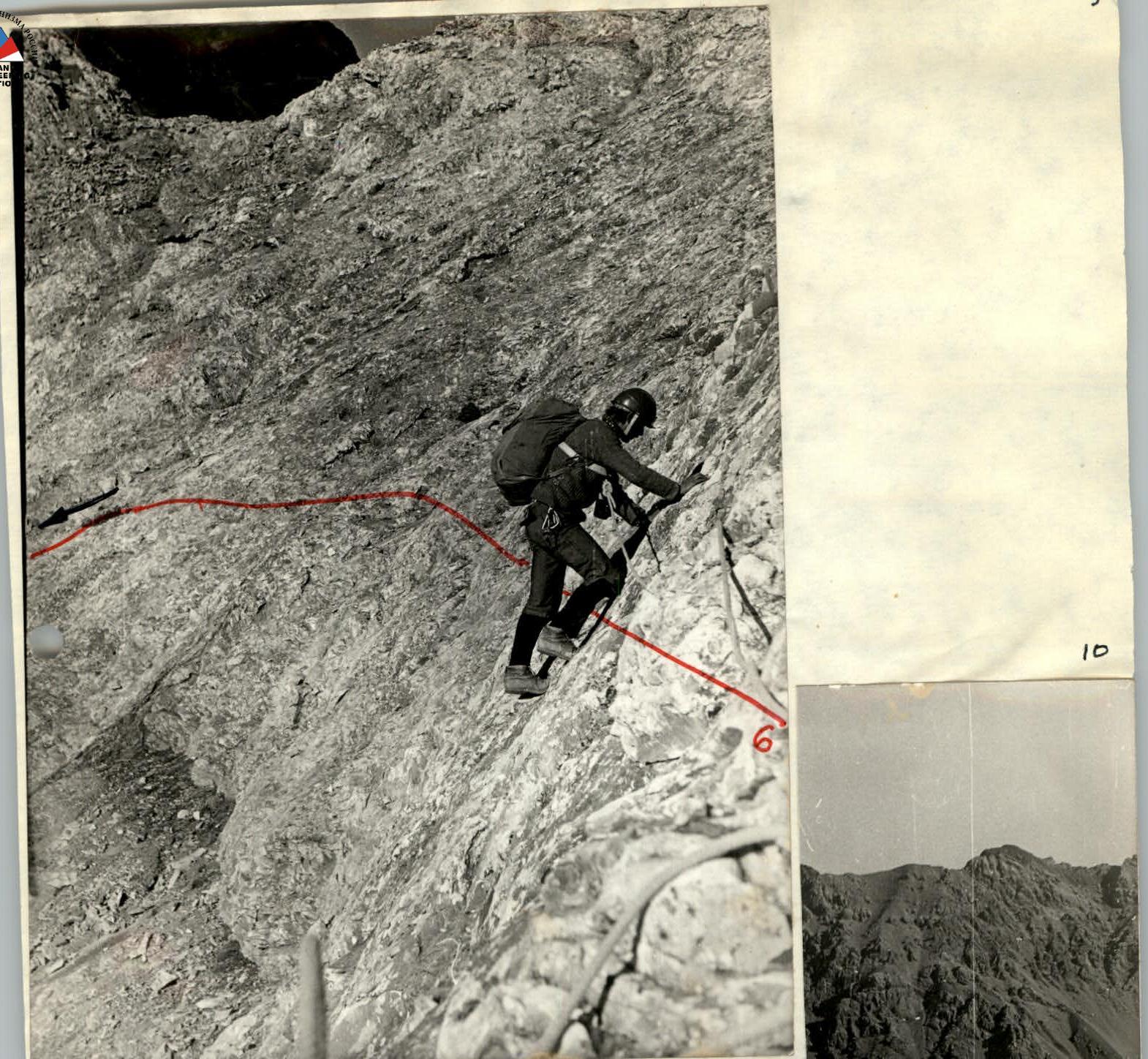
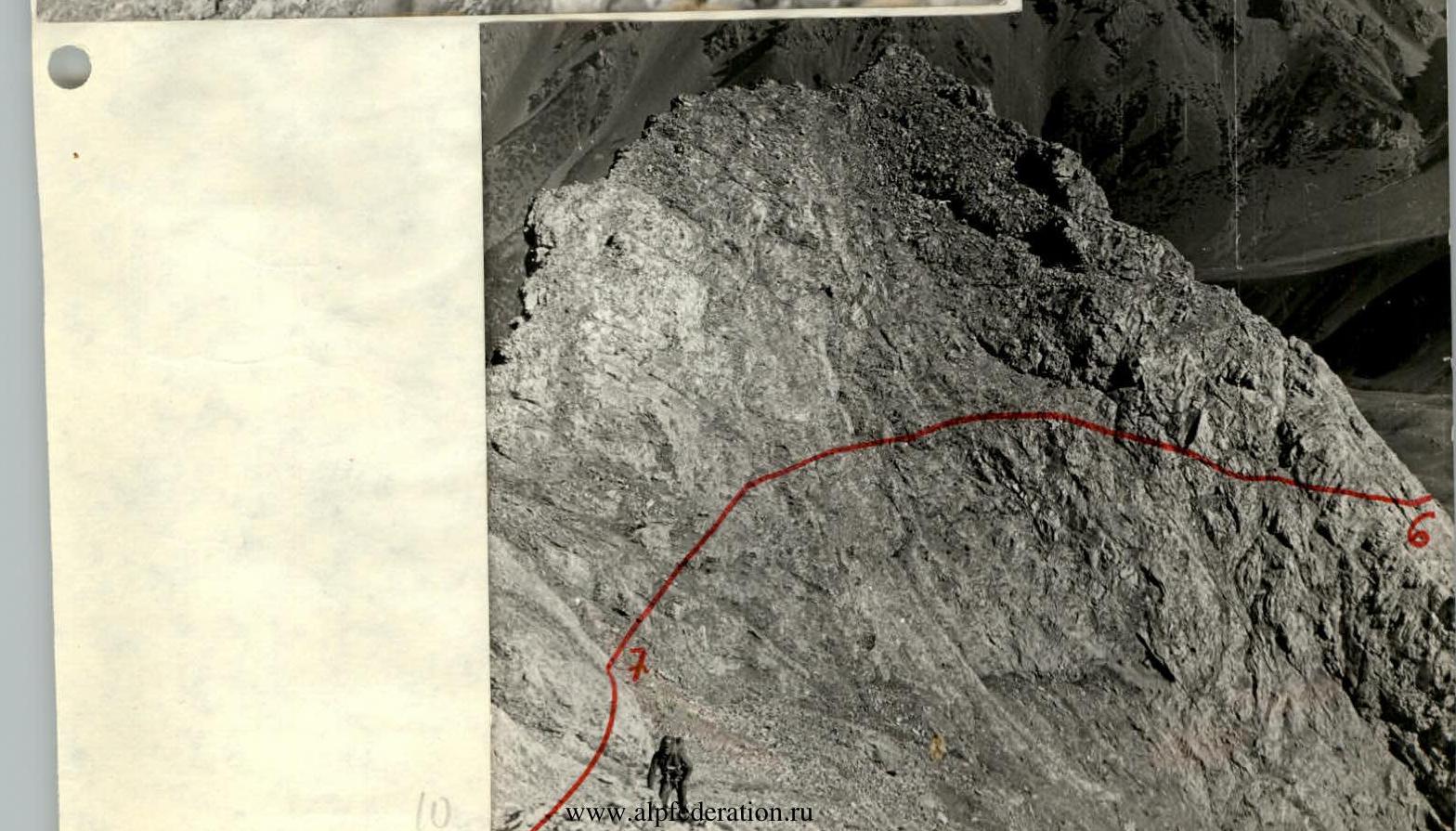
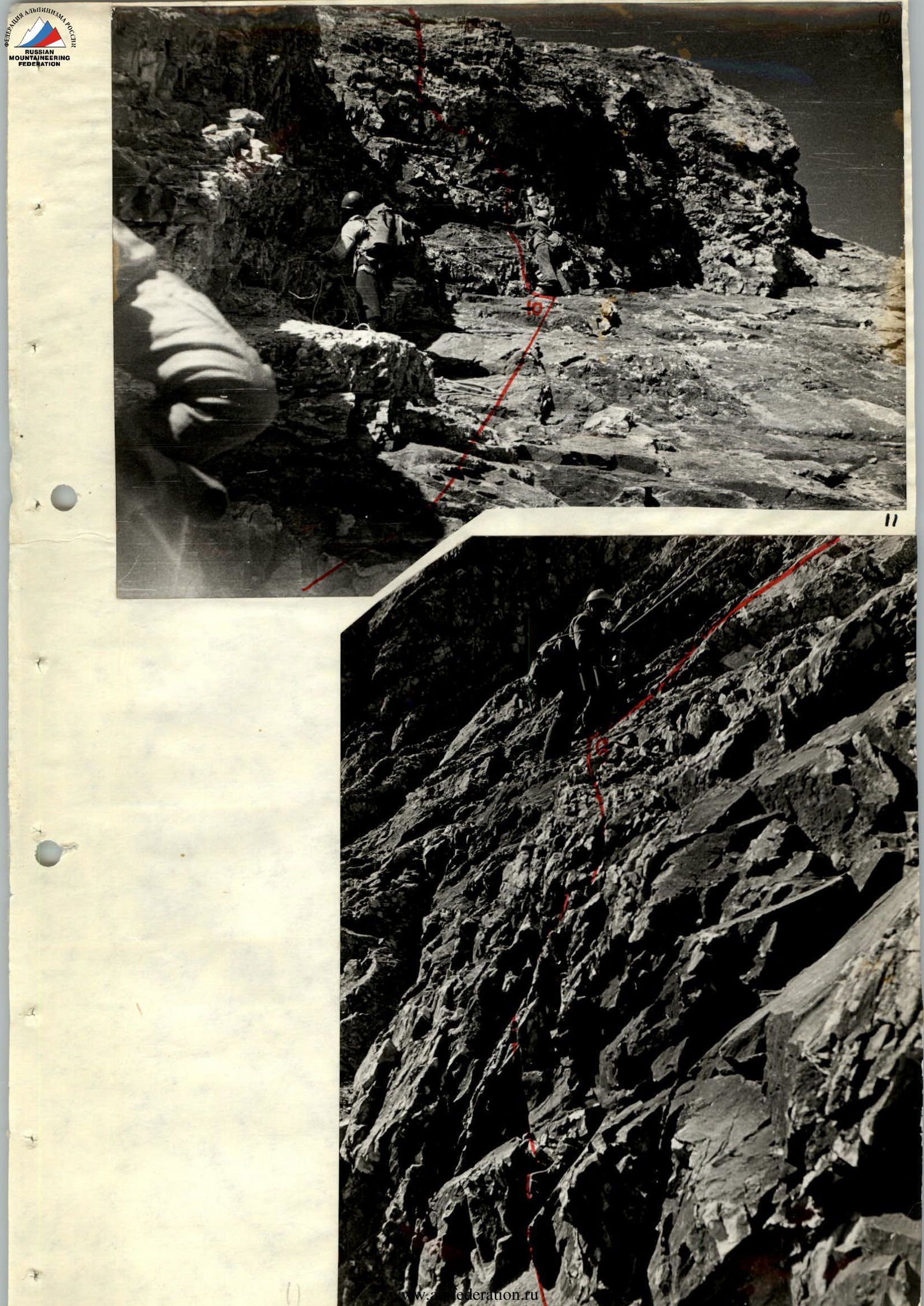
10:00–10:35 R8–R9 80° 40 m. Rocky wall. Category of difficulty: 5A. Unstable rocks, loose stones. Small holds — "catches", friction. Belaying: Five rock pitons, outcrops; alternating.
10:35–11:10 R9–R10 80° 40 m. Second rocky wall. Category of difficulty: 4B. Belaying: Four rock pitons, outcrops; alternating.
11:10–11:45 R10–R11 95° 20 m. Overhanging rocky wall, followed by inclined slabs. Category of difficulty: 5A. Highly unstable rocks, many loose stones — blocks. Few reliable cracks. Belaying: Six rock pitons; rare outcrops; alternating. Climbing: 40 m of rope, free climbing.
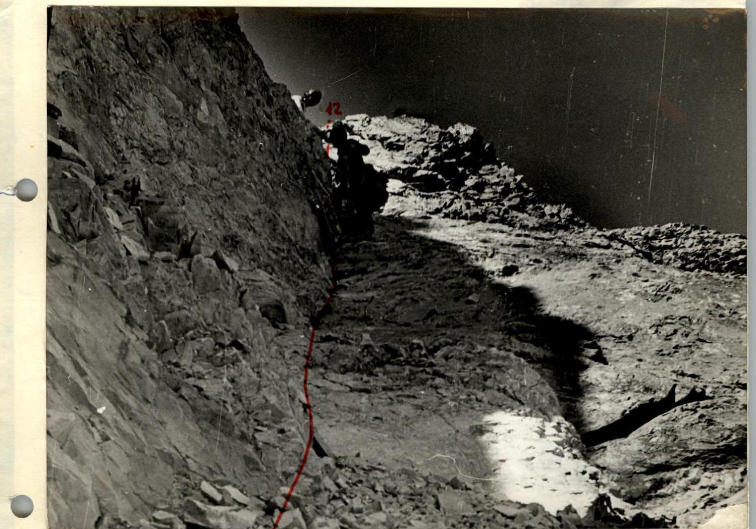
11:45–13:00 R11–R12 60° 120 m. Approach to the pre-summit ridge via slabs. Category of difficulty: 4B. Monolithic slabs covered with limestone crumb. Belaying: Seven rock pitons, outcrops; alternating. Climbing: Free climbing.
13:00–14:55 R12–R13 70° 160 m. Jagged narrow (up to 20 cm) rocky ridge, very steep on both sides. Category of difficulty: 5A. Highly unstable rocks! Belaying: Seven rock pitons, outcrops; alternating. Climbing: 40 m of rope, free climbing.
14:55–15:10 R13–R14 20° 100 m. Scree ridge to the summit of Kyzkochkan. Category of difficulty: 1. Large scree. Belaying: Simultaneous. Climbing: Without handholds.
From 15:30 to 17:30 on 03 September 1977, descent via scree couloirs to the south and moraine between Kyzkochkan and LVO peak, exit to the Joldzhilga gorge at the start of the route; from here to the base camp "2800" is another 0.7 hours.
Additions to the table
- Approach: from Osh city by car to the parking lot VS USSR-74 at the border of the arch forest of Mazar mountain in the Suichikty gorge; through the forest to the Joldzhilga river and upstream along its left (or.) bank, bypassing the Gelintash peak. Having gained altitude under the eastern walls of Gelintash, the group sees the Northern ridge of Kyzkochkan (from the forest border — 1.5 hours).
- On the first day, work on the ridge for 4–5 hours to a convenient and safe stopping point under the gendarme, where we spent the night. Note that our group covered this section very quickly because on 20.08.1977, during rock climbing training, the duo V. Khramtsov—S. Lensky worked on the ridge for 4 hours! On the second day, start as early as possible — the central part of the wall is exposed to rockfall in the second half of the day.
- At the time of our ascent, the route was in ideal condition; true, there was no water anywhere. When snowy, the route is dangerous to climb, especially the rockfall-prone sections 5–12. There is no confidence in piton belays. The route was climbed only for its beauty and logic — after rock climbing training, we knew that pleasant climbing was not expected.
- On the "Tooth" hammer an ice piton; in the kit — petals, wedges, and standard rock pitons.
12
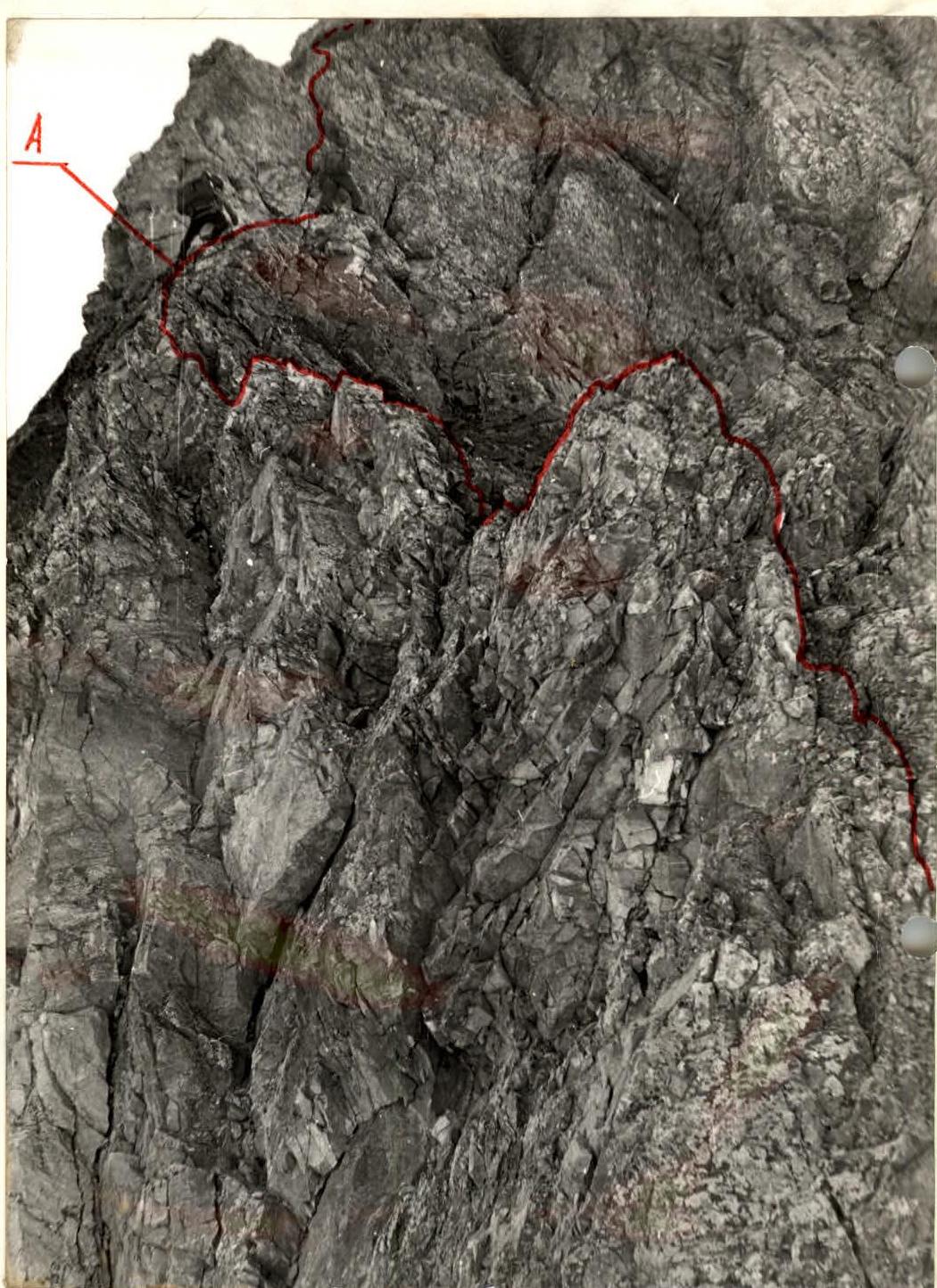
Section R12–R13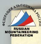
13
Classification proposals
Our group prepared for this route as a first ascent of 5A category, not lower.
Now, after completing it, we do not insist on 5A category, primarily so that there are no "queues" for this rather dangerous rock route. For a first 5A, the route is undoubtedly challenging; but for those with 4B experience, it is perfectly suitable (when experience of 5A ascents is already present).
In terms of movement organization and type of climbing, the route is similar to the 4B category route to Peak I.E. Babel. The pre-summit ascent of Kyzkochkan is more challenging than the key section on Azhaylyk 4B category. Overall, our route is undoubtedly more complex than rock difficulties of such 4B routes as Maria or VEI — Aurondag.
Based on the above, the group requests to include the route in the All-Union classification table of routes to mountain peaks as:
Kyzkochkan 4100 m, 4B category, via the N ridge.
Note: "Kyz" — Kyrgyz for "girl"; "kochkan"? According to one version, "kochkan" — a fence, a small enclosure for sheep; according to another — "kochkan" = "ran away". The gorge is called "Kyrgyz-Ata" ("Father of the Kyrgyz"), the neighboring


