Ascent Passport
- Ascent class — rock climbing
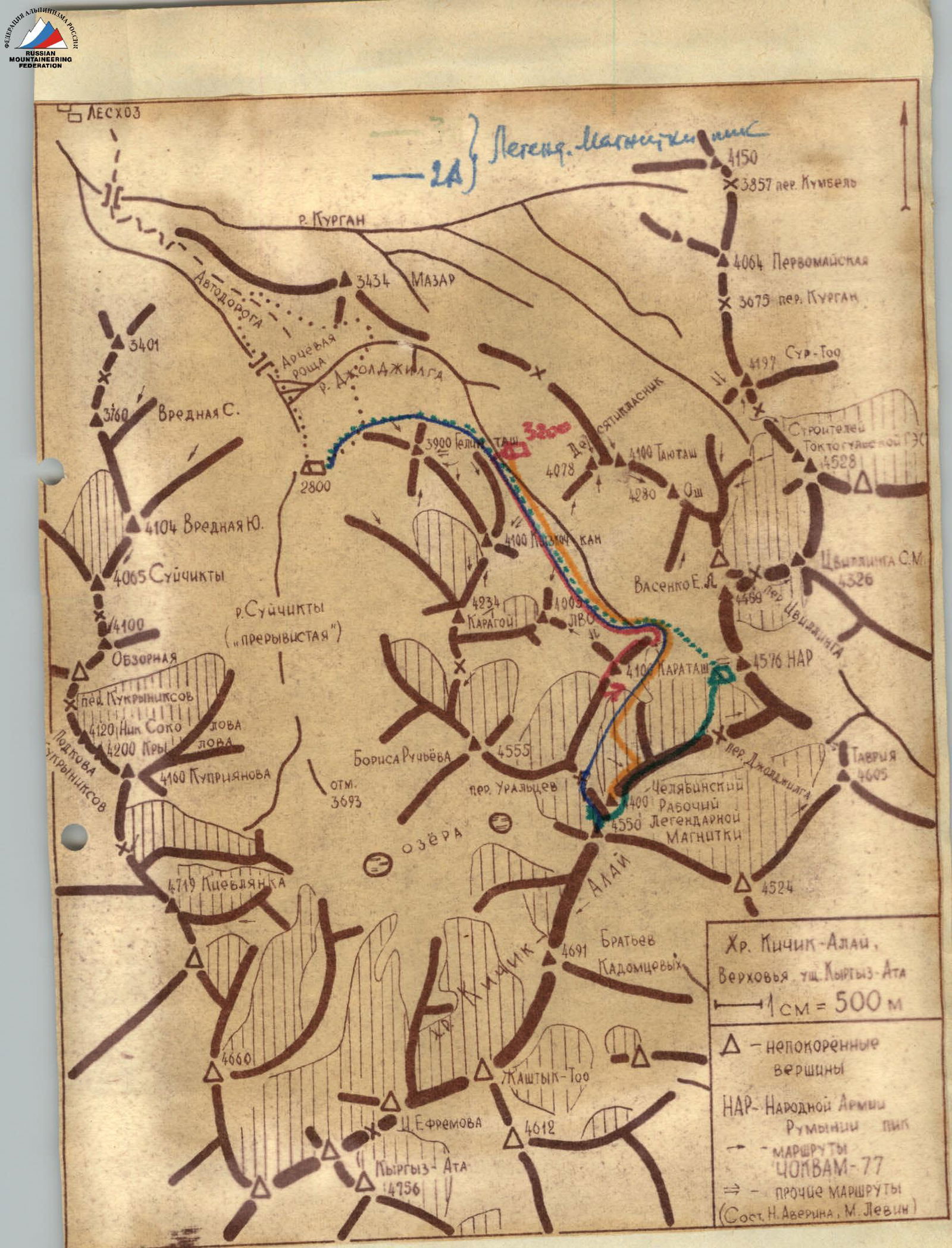
- Ascent area: Pamir-Alay range, Kikik-Alay ridge
- Karatash peak, height 4100 m, ascent route via the Eastern ridge
- Proposed difficulty category 3–6
- Route characteristics: Height difference 600 m, length of sections 5–6 km, average steepness 50°
- Pitons hammered in: For belaying: rock pitons 36 For creating ITO: ice pitons —, bolt pitons —
- Number of climbing hours: 7.9
- Number of nights and their characteristics —
- Full name of the leader, participants, and their qualifications:
- Agafonov L.L. — leader, 2nd sports rank
- Khandyuk S.A. — 2nd sports rank
- Averina N.V. — 2nd sports rank
- Belkov S.A. — 3rd sports rank
- Volodko A.P. — 2nd sports rank
- Team coach: Master of Sports Levin M.S.
- Date of departure to the route and return: September 4, 1977
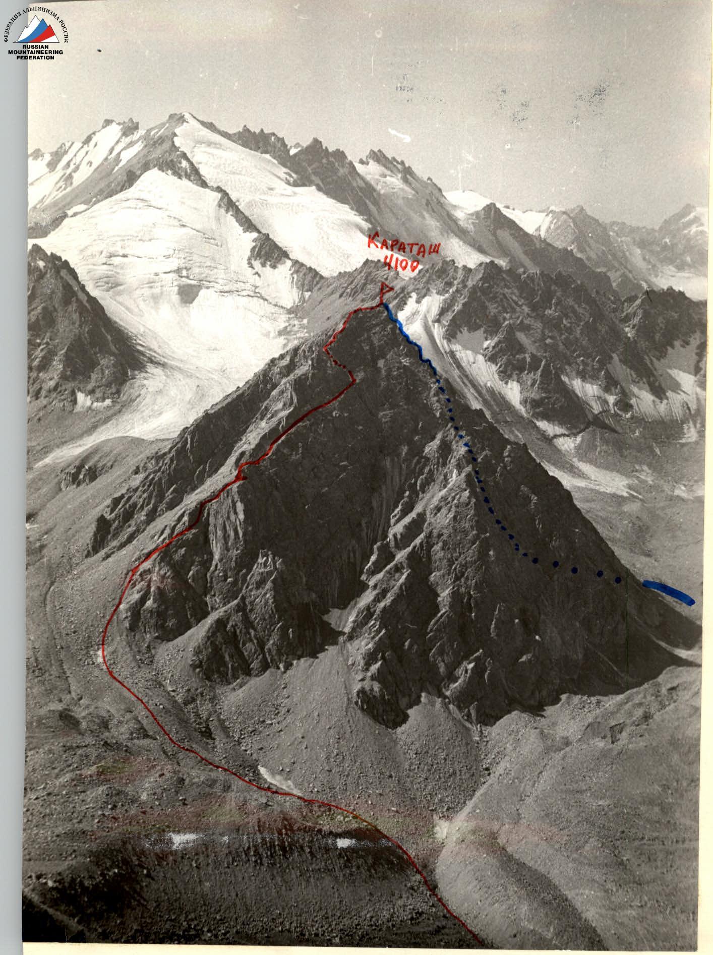
The described route — Route of the USSR Climbing Team VII/77 (B. Tenigin)
Date, time. Designation, average steepness, length. Terrain characteristics, difficulty. Terrain condition, weather condition. Belaying. Passage.
September 4, 1977. Approach to the start of the route from the assault camp "3200" on the green meadow in the Djoldjilga valley — 2 hours 30 minutes.
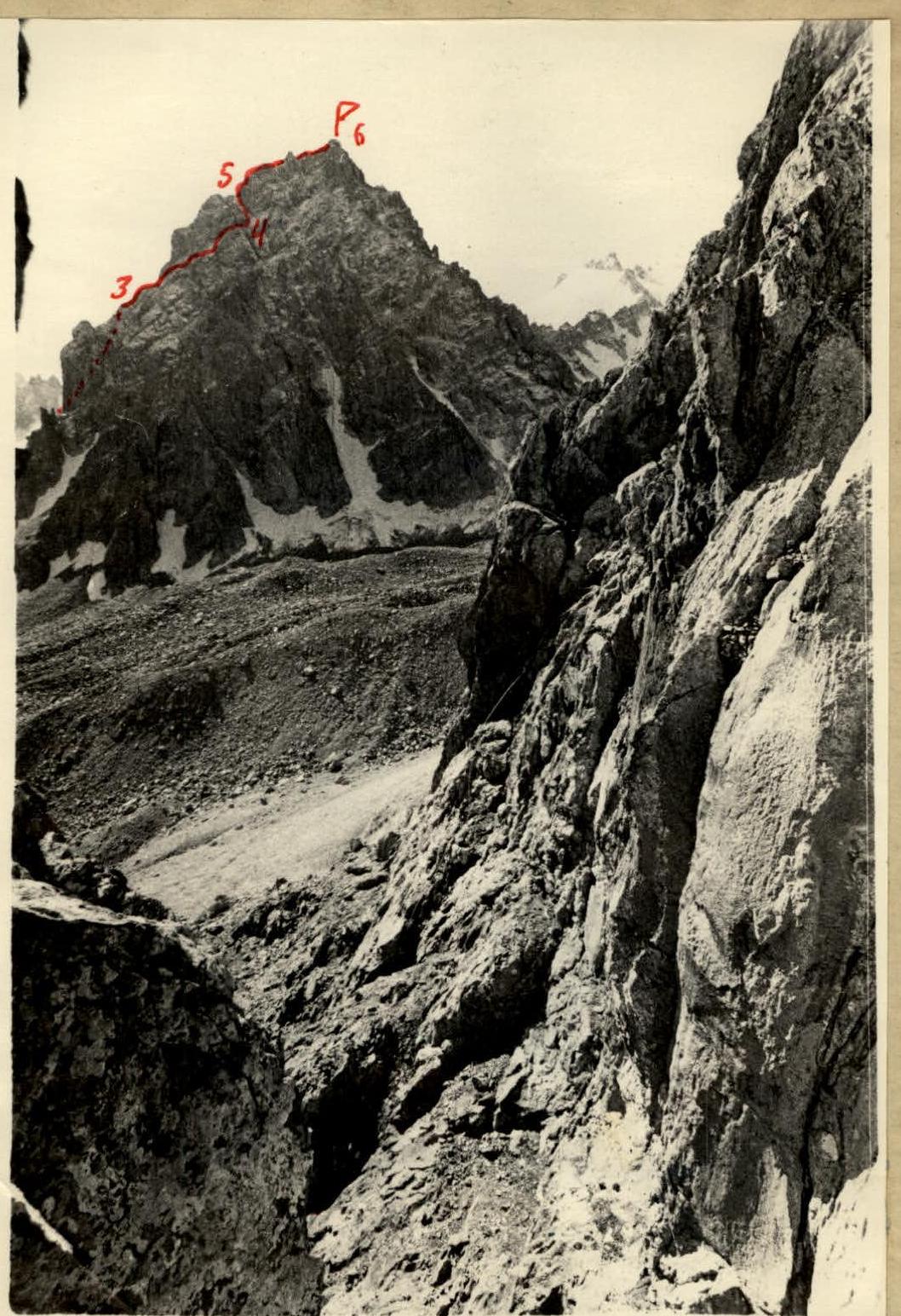
8:40–9:00. R0–R1. 30°, 70 m. Inclined slab. Category difficulty 2A. Smooth rocks, loose stones. Sunny. Belaying: alternately through ledges. Passage: free climbing.
9:10–10:20. R1–R2. 70°, 70 m. Oblique shelves and internal corner of the wall. Category difficulty 3B. Few good handholds, loose stones. Few reliable cracks. Belaying: 14 rock pitons, ledges — alternately. Passage: free climbing.
10:30–11:00. R2–R3. 45°, 100 m. Rocky ridge. Category difficulty 2B. Loose stones. Belaying: alternately through ledges.
11:30–12:50. R3–R4. 60°, 120 m. Weakly defined ledges of the northern rocky wall. Category difficulty 3B. Rocks are snow-covered, loose stones, ice formations, depth! Careful traversing with thorough belaying. Belaying: 19 rock pitons, ledges — alternately.
12:55–13:10. R4–R5. 65°, 80 m. Wide vertical crack. Category difficulty 3B. Monolith of good friction. Belaying: three rock pitons, ledges — alternately.
13:10–13:30. R5–R6. 20°, 150 m. Rocky ridge. Category difficulty 2A. Destroyed rocks. Belaying: simultaneously "on the entire rope".
Descent to the south through the couloir network and return to the start of the route — from 14:05 to 16:00 by free climbing on the southern slope, then walking on the moraines. On the summit, a note from the USSR Climbing Team led by B. Tenigin from July 1977, indicating that they removed a note from the first ascender A. Balinsky from 1959.
APPROACHES: Osh city — Karakoy forestry — bridge beyond the forestry — 2 hours 30 minutes by car. From here, up the Suichikty valley, along the right (or.) bank to the juniper forest west of the Maazar mountain. Through the forest, bypass Maazar mountain on the right, cross to the left bank of the Djoldjilga river and up along it to the axial line of the valley. From here, Karatash is visible (no more than 3 hours with backpacks from the bridge over the Kurgan river beyond the forestry) — another 2–3 hours of approach on the moraines.
CLASSIFICATION PROPOSALS: Out of 270 "control" meters, 120 m of wall traversing is psychologically "pressing" due to the depth underfoot and the presence of ice formations, complicating climbing in galoshes. "Spartakiad" in "Ala-Archa" and "Izyyskatel" are calmer, "Chokan Valikhanov" is simpler. The team requests that the route they completed be included in the KTMGV USSR as:
Karatash, 4100 m, 3B category difficulty, rock climbing, via the Eastern ridge.