
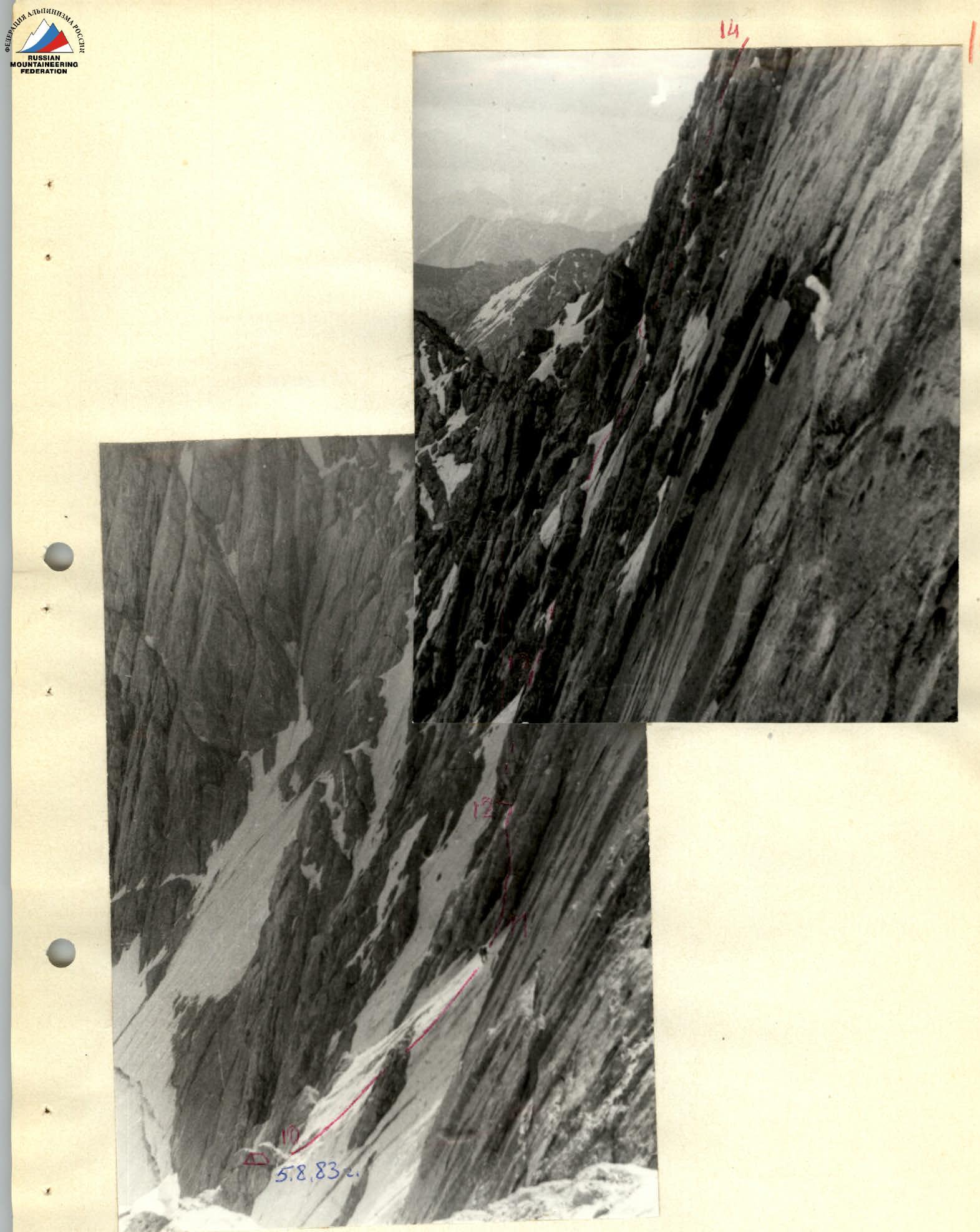
Route profile. View from the Martynov — Levchenko route
Table of main characteristics of the ascent route
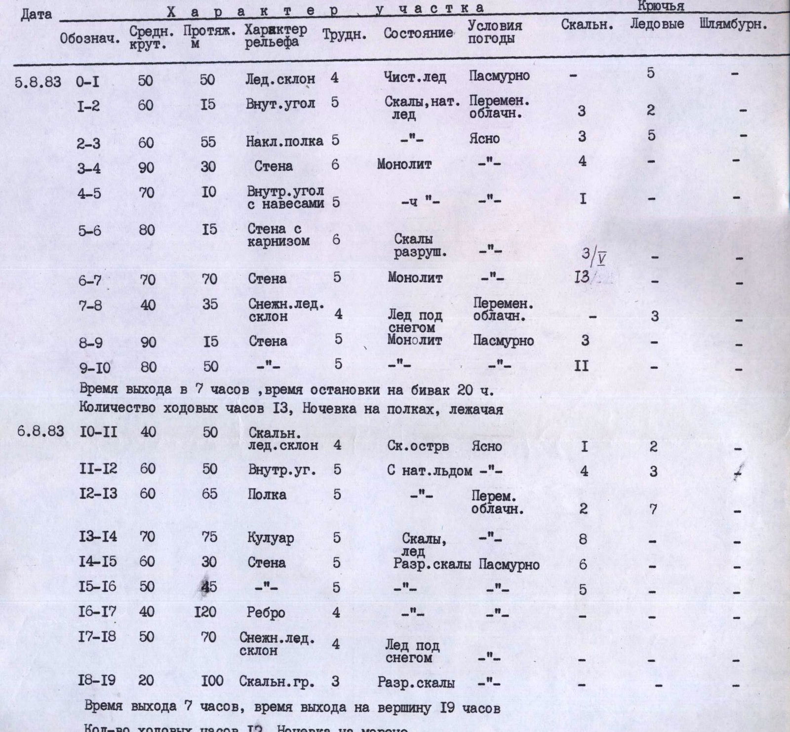
| Date | Designation | Avg. slope | Length (m) | Terrain characteristics | Difficulty | Condition | Weather conditions | Rock | Ice | Bolted |
|---|---|---|---|---|---|---|---|---|---|---|
| 5.8.83 | 0–I | 50 | 50 m | Ice slope | 4 | Pure ice | Cloudy | – | 5 | – |
| I–2 | 60 | 15 m | Inner corner | 5 | Rocks, nat. ice | Variable clouds | 3 | 2 | – | |
| 2–3 | 60 | 55 m | Inclined shelf | 5 | —" | Clear | 3 | 5 | – | |
| 3–4 | 90 | 30 m | Wall | 6 | Monolith | —" | 4 | – | – | |
| 4–5 | 70 | 10 m | Inner corner with overhangs | 5 | —" | —" | I | – | – | |
| 5–6 | 80 | 15 m | Wall with a cornice | 6 | Destoyed rocks | —" | – | – | – | |
| 6–7 | 70 | 70 m | Wall | 5 | Monolith | —" | 3 | II | – | |
| 7–8 | 40 | 35 m | Snowy ice slope | 4 | Ice under snow | Variable clouds | – | 3 | – | |
| 8–9 | 90 | 15 m | Wall | 5 | Monolith | Cloudy | 3 | – | – | |
| 9–10 | 80 | 50 m | —" | 5 | —" | —" | – | II | – | |
| 6.8.83 | 10–II | 40 | 50 m | Rocky ice slope | 4 | Rock island | Clear | I | 2 | – |
| II–12 | 60 | 50 m | Inner corner | 5 | With nat. ice | —" | 4 | 3 | ||
| 12–13 | 60 | 65 m | Shelf | 5 | —" | Variable clouds | 2 | 7 | – | |
| 13–14 | 70 | 75 m | Couloir | 5 | Rocks, ice | —" | 8 | – | – | |
| 14–15 | 60 | 30 m | Wall | 5 | Destroyed rocks | Cloudy | 6 | – | – | |
| 15–16 | 50 | 45 m | —" | 5 | —" | —" | – | – | – | |
| 16–17 | 40 | 120 m | Ridge | 4 | —" | —" | – | – | – | |
| 17–18 | 50 | 70 m | Snowy ice slope | 4 | Ice under snow | —" | – | – | – | |
| 18–19 | 20 | 100 m | Rocky ridge | 3 | Destroyed rocks | —" | – | – | – |
Departure time 7:00, time of bivouac stop 20:00. Number of travel hours 13 hours. Overnight stay on shelves, lying down.
Departure time 7:00, time of reaching the summit 19:00. Number of travel hours 12 hours. Overnight stay on the moraine.
Explanations for the table
The group consisting of Kukushkin A.F., Misočko O.V. completed a variation of the ascent route followed by the group of Vasiliev in July 1983.
Up to the R15 section, the group retraced the route taken by the first ascendants.
Further, considering that:
- the most technically challenging sections have been passed;
- there is an increased rockfall hazard during the ascent,
the group continued the traverse and reached the edge of the Northern wall of the Karaganda S peak.
We believe that the route corresponds to the 5B category of difficulty.