
5.1.278 5.1.Б. 14 58 4/n.i.8. IR. 531 13.2.83 LENINGRAD CLIMBING FEDERATION 5.1.3.13
REPORT
on the ascent of the Leningrad Regional Council SDSO "Burevestnik" team to Mt. SEVERNAYA KARAGANDA, 4800 m via the center of the north wall
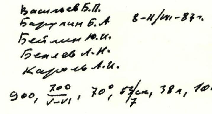
Vasiliev B. P. Barulin B. A. Beilin Yu. I. Belyaev L. N. Karol A. I. 8–11/08-83 900, 300, 70°, 8 hours/shift, 381, 10 km/h, 33/camming device, 38 hours, 2 legs.
Pamir-Alai
July 7-11, 1983

Climbing Area Map
 R26–R27, 40, 300 m, 3
 R23–R24, 45, 40 m, 4
R22–R23, 70, 20 m, 5
R21–R22, 45, 30 m, 4
R20–R21, 50, 50 m, 4
R19–R20, 80, 15 m, 5
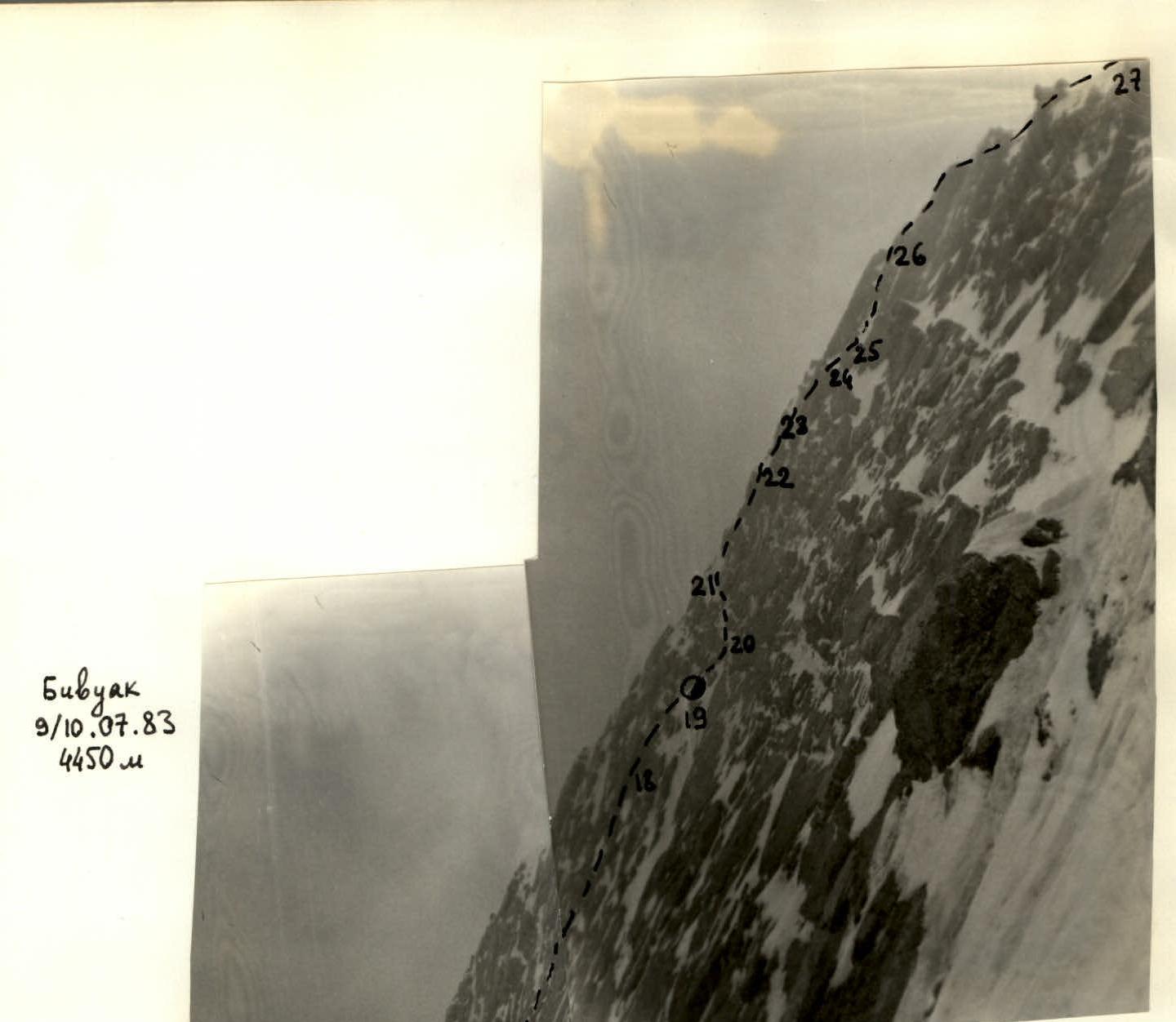
Bivouac July 9-10, 1983, 4450 m.
R18–R19, 50, 15 m, 4
R23–R24, 45, 40 m, 4
R22–R23, 70, 20 m, 5
R21–R22, 45, 30 m, 4
R20–R21, 50, 50 m, 4
R19–R20, 80, 15 m, 5
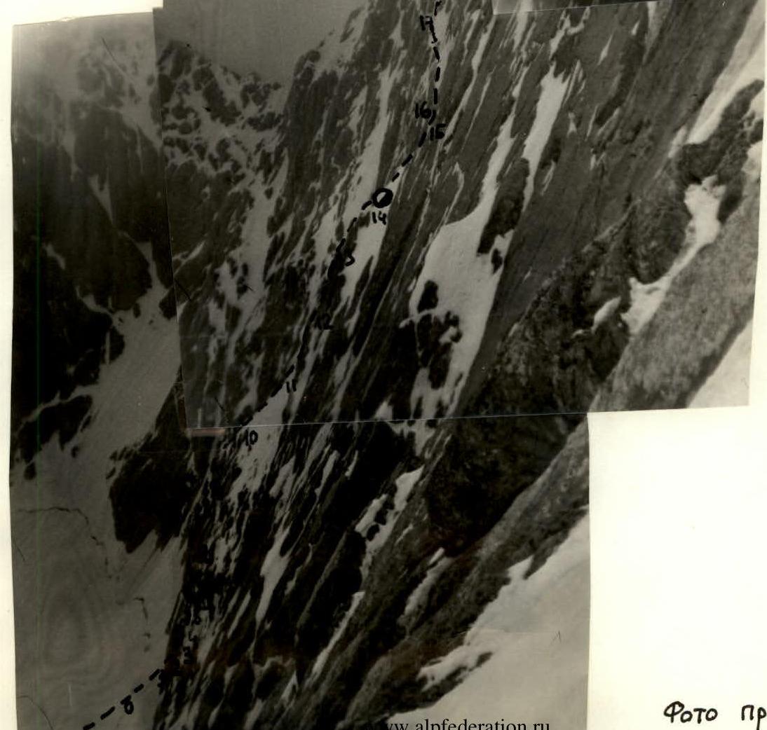
Bivouac July 9-10, 1983, 4450 m.
R18–R19, 50, 15 m, 4
R17–R18, 60, 120 m, 5 R16–R17, 45, 30 m, 4 R15–R16, 80, 8 m, 4 R14–R15, 50, 10 m, 5 Bivouac July 8-9, 1983, 4300 m. R13–R14, 45, 15 m, 4 R12–R13, 80, 40 m, 5 R11–R12, 80, 20 m, 5 R10–R11, 45, 70 m, 4 R9–R10, 90, 15 m, 5 R8–R9, 100, 8 m, 6, A1 R7–R8, 80, 20 m, 6 R6–R7, 70, 20 m, 5 R5–R6, 60, 20 m, 5 R4–R5, 50, 15 m, 4 R3–R4, 50, 10 m, 4 R2–R3, 70, 15 m, 5 R1–R2, 80, 15 m, 6, A1 R0–R1, 45, 30 m, 5
TABLE OF MAIN CHARACTERISTICS
| Designation | Average steepness | Length, m | Terrain characteristics | Difficulty | Condition | Weather conditions | Rock pitons | Ice pitons | Bolts | Camming devices |
|---|---|---|---|---|---|---|---|---|---|---|
| R0–R1 | 45 | 30 | ice slope | 5 | monolith | from 13:00 | 3 | |||
| R1–R2 | 80 | 15 | inner corner at the junction of two slabs | 6 | monolith | snowfall | 2, II | 1 | 3 | |
| R2–R3 | 70 | 15 | groove | 5 | iced | 2 | 4 | |||
| R3–R4 | 50 | 10 | ice shelf | 4 | 1 | 2 | 2 | |||
| R4–R5 | 50 | 15 | ice shelf | 4 | 1 | 2 | 1 | |||
| R5–R6 | 60 | 20 | groove | 5 | icy | 2 | 3 | 1 | ||
| R6–R7 | 70 | 20 | wall | 5 | broken rocks | 4 | 1 | 1 | 2 | |
| R7–R8 | 80 | 20 | wall | 6 | smoothed rocks | 3 | 1 | 1 | ||
| R8–R9 | 100 | 8 | cornice | 6 | monolith | 3 | 2 | |||
| R9–R10 | 90 | 15 | chimney | 5 | icy | 3 | 1 | 1 | ||
| R10–R11 | 45 | 70 | snowy slope | 4 | good | 2 | 1 | 1 | ||
| R11–R12 | 80 | 20 | chimney | 5 | rime ice | 2 | 2 | 3 | ||
| R12–R13 | 80 | 40 | wall | 5 | broken rocks | 6 | 1 | 3 | ||
| R13–R14 | 45 | 15 | snow-ice slope | 4 | 2 | 1 | ||||
| R14–R15 | 50 | 10 | oblique ice shelf | 5 | good | 1 | 1 | |||
| R15–R16 | 80 | 8 | inner corner | 4 | icy | from 16:00 — fog, snowfall | ||||
| R16–R17 | 45 | 30 | ice slope | 4 | 2 | 1 | 1 | |||
| R17–R18 | 60 | 120 | ice groove | 5 | 10 | 8 | 1 | 5 | ||
| R18–R19 | 50 | 15 | snow-ice cape | 4 | 1 | |||||
| R19–R20 | 80 | 15 | wall | 5 | rime ice | good | II, 1 | 1 | 2 | |
| R20–R21 | 50 | 50 | ice slope with rock outcrops | 4 | 3 | 2 | 1 | |||
| R21–R22 | 45 | 30 | snow-ice couloir | 4 | 2 | 1 | ||||
| R22–R23 | 70 | 20 | chimney | 5 | icy | 3 | 2 | 2 | ||
| R23–R24 | 45 | 40 | snow-ice slope | 4 | 2 | 2 | 1 | |||
| R24–R25 | 70 | 5 | wall | 4 | broken rocks | 1 | 1 | |||
| R25–R26 | 50 | 50 | snowy slope | 4 | 1 | 1 | 2 | |||
| R26–R27 | 40 | 300 | snowy ridge with rock outcrops | 3 | 2 | 2 |
Bivouac in the 1st cirque. Start of work — 8:00, end of work — 19:00. Total travel hours — 11.
The overnight stay was dug and cut on a snow-ice slope, semi-reclining. Departure time — 8:00, time of stopping at the bivouac — 19:00. Total travel hours — 11.
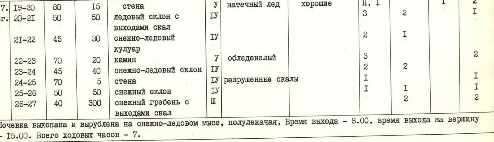 The overnight stay was dug and cut on a snow-ice cape, semi-reclining. Departure time — 8:00, time of reaching the summit — 15:00. Total travel hours — 7.
Sections
R0–R1. From the bergschrund, the ice slope leads directly under the inner corner. Insurance via ice screws. R1–R2. Inner corner formed by the "overlapping" of two slabs. In some places, it overhangs. Pitons and camming devices go only into the joint of the slabs. Passed using artificial technical means (AITO). There are no handholds, and there are few cracks. R2–R3. Icy groove. The rocks are destroyed, the cracks are filled with ice. Difficult to pass. R3–R4. Ice slope — shelf, leads under the wall of the bastion. Insurance via ice screws. R4–R5. Traverse along the ice slope to the left, under the left side of the bastion. R5–R6. The groove is icy. Very difficult climbing. Few cracks for driving pitons. Snow covers the rocks. R6–R7. Wall. The rocks are destroyed. Climbing in galoshes. To secure the rope, it is necessary to use bolts. R7–R8. Wall. Smoothed rocks, in some places "ram's foreheads", few cracks. Climbing in galoshes. R8–R9. Cornice. Climbing in galoshes, few cracks. AITO. R9–R10. Vertical chimney, ending in a smooth slab. Bolt for securing the rope. End of the first bastion. R10–R11. Snowy slope. Movement straight up under the second rock bastion. R11–R12. Narrow chimney, very difficult to move with a backpack. Many cracks. R12–R13. From the chimney to the left under the wall, which leads to the top of the bastion. The rocks are destroyed. R13–R14. Snow-ice slope. Ice screws. The slope leads under vertical smooth slabs. R14–R15. Traverse under the wall along the ice shelf. At the end of the shelf, there is a bolt for rappelling. R15–R16. Rappelling down the couloir under the wall onto a snow-ice slope. R16–R17. Traverse to the left under the ice groove, up to the right. R17–R18. Ice groove with rock outcrops leads to a snow-ice cape. Rock outcrops are snow-covered, in some places filled with ice. Insurance via ice and rock pitons, camming devices. R18–R19. Snow-ice cape. Ice under the wall. R19–R20. Wall, filled with ice, few cracks, AITO. Bolt for securing the rope. Above are smooth slabs and cornices with an overhang of 7–10 m. An attempt was made to bypass on the left. R20–R21. Traverse to the left along a snow-ice slope with rock outcrops under a snow-ice couloir, going up to the left. R21–R23. The couloir leads to a steep, complex chimney with a small number of cracks, the bottom of the chimney is filled with ice. R23–R24. From the chimney, movement to the right and up along a snow-ice slope under a wall. R24–R25. Steep, low wall, very destroyed rocks. R25–R26. From the wall, a snow-ice slope leads to a ridge. R26–R27. Ridge with rock outcrops. Simultaneous movement.
Brief description of the approach to the north wall of Mt. Severnaia Karaganda
From the base camp at the blockage opposite the third cirque of the Gaumysh gorge, cross the river by stones and move along the right bank of the river. To reach the first cirque — 40 minutes. Along a destroyed rocky or talus ridge, or to the right of it along a long snowy couloir, ascend to the first cirque (R1–1.5 hours). The assault camp is located on the upper terrace of the cirque at the foot of the glacier. The approach to the wall along the left moraine takes 30 minutes.
Team leader: St
Profile photo