I. Climbing category
technical 2. Climbing area, ridge Alaisky 3. Peak, its height, climbing route Tekelik Yuzhny named after Oлеко Dundich 4925 m via the Southern ridge 4. Proposed category complexity 3B (first ascent) 5. Route characteristics: height difference ridge 1000 m length of sections 5–6 c/tr average steepness 38° 6. Pitons hammered: for belaying, for creating artificial holds rock - 3 ice bolts 7. Number of climbing hours 12 8. Number of nights and their characteristics on the lateral moraine of the Kemisdykty glacier before the route 9. Surname, name, patronymic of the leader, participants and their qualification Liplyavy Igor Vasilyevich 2nd sp. category — leader Zaev Eduard Fedorovich MS — participant Chetkin Alexander Nikolaevich 2nd sp. category 10. Team coach: Zaev Eduard Fedorovich 11. Date of departure and return Departure: 28 July 1977 Return: 29 July 1977
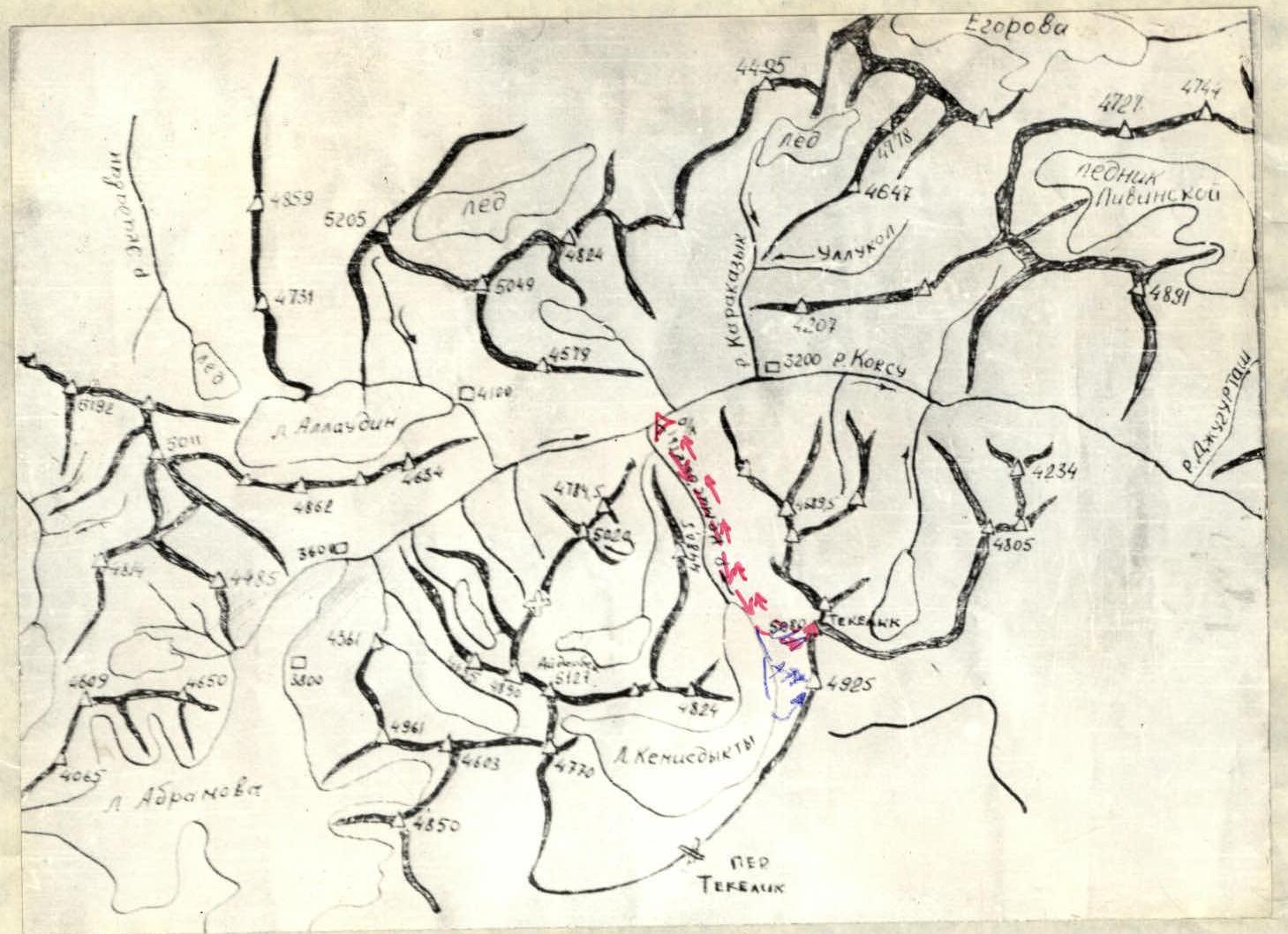
Map of the climbing area
Brief description of the approach to the climbing route
From the base camp, located at the confluence of the Kemisdykty river and the Kok-su river, along the right (orographically) bank of the Kemisdykty river to the tongue of the Kemisdykty glacier and further along the glacier to the lateral moraine at the beginning of the route.

| DATE | DESIGNATION | AVERAGE STEEPNESS IN DEGREES | LENGTH IN M | RELIEF CHARACTER | DIFFICULTY | CONDITION | BELAY | HOURS, NIGHT CONDITIONS |
|---|---|---|---|---|---|---|---|---|
| 29.07.1977 | R0–R1 | 40° | 200 | couloir | 1 | scree | simultaneous movement | 1 h 10 min |
| R1–R2 | 45° | 300 | ridge | 3 | rocks | 2, belay through ledges | 1 h 50 min | |
| R2–R3 | 35° | 400 | ridge | 3 | rocks | belay through ledges | 1 h 40 min | |
| R3–R4 | 30° | 150 | ridge | 1 | scree | simultaneous movement | 15 min | |
| R4–R5 | 40° | 200 | ridge | 3 | rocks | 1, belay through ledges | 1 h 45 min | |
| R5–R6 | 10° | 100 | ridge | 2 | rocks | simultaneous movement | 20 min |
Brief explanations for appendix 2 table
Section R0–R1: Wide scree couloir leading to the beginning of the ridge.
Section R1–R2: The exit to the rocks of the ridge is carried out in its right part by overcoming a 3 m wall (1 rock piton) along a crack to a ledge under overhanging rocks. Along the ledge — exit to a platform to the left. From the platform — ascent along a crack in a vertical wall 8 m (1 rock piton) — exit to the broken rocks of the ridge. To the summit rise, movement is simultaneous and with belay through ledges.
Section R2–R3: Descent from the rise to a saddle (100 m), formed by small couloirs approaching from the left and right, ending in the lower part with drops. From the saddle — ascent along a heavily dissected rocky ridge. Movement is simultaneous and with variable belay through ledges. In the upper part of the rise — characteristic yellow rock.
Section R3–R4: From the depression after the rise, ascent to the next rise along a scree ridge.
Section R4–R5: Steep jagged rocky rise. In the initial part (20 m from the depression of the ridge), the exit to the ridge is carried out through a passage formed by a stone jammed in a crack (yoke). In the middle of the section — exit to a monolithic rock slab (20 m), belay through a rock piton. For the rest of the section — movement with belay through ledges.
Section R5–R6: Almost horizontal rocky ridge, jagged. Passed by simultaneous movement. At the summit — a large stone (4 m). Further along the ridge — a large gap separating peak O. Dundich from peak Tekelik. From the gap, steep rocky couloirs with drops and "ram's foreheads" at the bottom diverge to the left and right. Descent — via the ascent route.
It is proposed to name the peak in honor of the hero of the civil war, Serb Oлеко Dundich, a participant in the liberation of Voronezh from Shkuro's gangs.