Ascent Passport
I. Ascent classification: technical.
-
Ascent area: Southern spurs of the Alay Ridge, Kок-Су valley.
-
Tekelik Peak, 5080 m, NE edge.
-
Proposed difficulty category: 5B.
-
Route characteristics: height difference 5080–5820 = 1260 m, length of technically difficult sections 540 m, average steepness 60°.
-
Protection: 63 rock anchors, 29 ice screws, 23 rappel rings with carabiners.
-
Total climbing time: 23 hours.
-
Number and characteristics of bivouacs: two bivouacs, good conditions.
-
Team leader: KOLCHIN Alexander Alexandrovich — Master of Sports of the USSR. Team members:
- Grekhov Igor Vsevolodovich — Candidate for Master of Sports
- Razumov Yuri Mikhailovich — Candidate for Master of Sports
- Balyberdin Vladimir Sergeevich — 1st sports category
- Silin Boris Mikhailovich — 1st sports category
-
Team coaches: Kolchin A.A. — Master of Sports of the USSR, Korkin I.V. — Master of Sports.
-
Departure date from camp: August 2, 1977. Return to camp: August 15, 1977.
Route Description
(Explanations for the table of main characteristics) The route starts about one rope length to the left of the NE ridge edge and initially goes along an inner corner and then along slabs (R0–R1) to a rock mulde with sheer walls above it. The mulde is clearly visible from the snow slope below the route. On the rock ledge in the upper left part of the mulde is a control cairn. From the cairn straight up the slabs to the main ridge (R1–R2). Climbing in these sections is not very difficult, but it's hard to organize protection. There are no outcrops, and there are few cracks.
After reaching the ridge:
- One rope length to the first red-colored gendarme along a steep, difficult slab (R2–R3);
- Then bypass the gendarme along a ledge on the left (R3–R4).
Cross the couloir between the first and second gendarmes and continue along the ledge to bypass the 2nd gendarme. Then:
- Up and to the right along a crack (R4–R5);
- Reach the top of the gendarme.
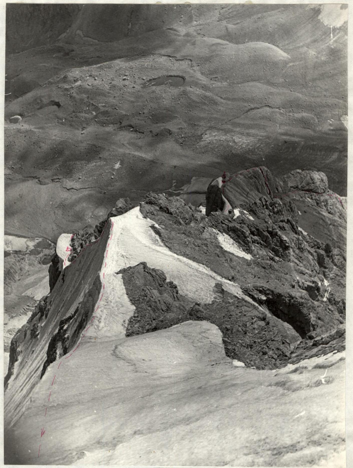
This (2nd) gendarme is clearly visible from the green bivouac sites as a large square red rock. There's a good bivouac site on the gendarme. 2nd control point.
Further:
- Along an ice bridge (R5–R6) (cornices!);
- Along simple rocky-scree slopes (R6–R7) to the 3rd gendarme.
It is somewhat to the left of the main ridge — zigzagging up, using diagonal rock ledges (R7–R8).
A narrow rock bridge between the 3rd and 4th gendarmes goes along the ridge and then straight along the ridge (R8–R9) — ascent to the 4th gendarme. On top of the 4th gendarme, there's a large ice cornice to the north. From the north, this cornice is clearly visible as the first ice shoulder of the ridge. In the pocket between the rocks and ice, there's a good bivouac site. Here, they organized the first bivouac.
Further:
- Ice ascent (R9–R10) to the second ice shoulder.
The ascent consists of two parts (with a small shoulder in the middle) and can be partially bypassed along the rocks on the left. On the second ice shoulder, there's also a possible bivouac site. Further (R10–R11) to the last ice ascent of the ridge (R11–R12), abutting a rock wall.
5 meters to the right of where the ridge abuts the wall, there's an inner corner filled with ice. Ascent along the rocks to the right of this corner (R12–R13) up and then along a ledge to the right (40 m) and up again. The rocks are partially covered with ice.
Reach the ice slope of the glacier forming the ice "cap" of the peak, to the left of the ice falls. Along the ice straight up to the main eastern ridge of the peak.
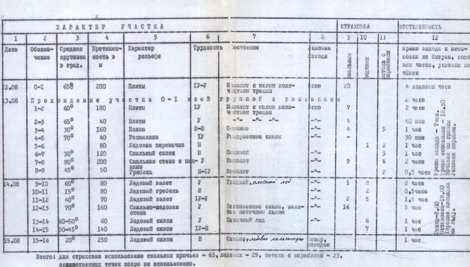
| Date | Section | Average steepness | Length in m | Terrain characteristics | Difficulty | Condition | Weather conditions | Rock anchors | Ice screws | Rappel rings with carabiners | Departure and bivouac stop time, climbing hours, bivouac conditions |
|---|---|---|---|---|---|---|---|---|---|---|---|
| August 12 | R0–R1 | 65° | 200 m | Slabs | 4–5 | Monolith with few cracks | Snowy | 20 | 4 hours | ||
| August 13 | R1–R2 | 60° | 180 m | Slabs | 4 | Monolith with few cracks | Snowy | 7 | 2 hours | ||
| August 13 | R2–R3 | 65° | 40 m | Slabs | 5 | 4 | 40 minutes | ||||
| August 13 | R3–R4 | 30° | 160 m | Ledge | 2–5 | Icy | Rocky debris | 4 | 5 | 1 hour | |
| August 13 | R4–R5 | 70° | 40 m | Cracks | 4 | Destroyed rocks | 30 minutes | ||||
| August 13 | R5–R6 | 80 m | Ice bridge | 1 | 2 | 1 hour | |||||
| August 13 | R6–R7 | 30° | 120 m | Rocky slope | 2 | Icy, rocky debris | 3 | 1 hour | |||
| August 13 | R7–R8 | 80° | 200 m | Rock wall with ledges | 5 | Monolith | 9 | 6 | 2 hours | ||
| August 13 | R8–R9 | 45° | 50 m | Ridge | 3–4 | Monolith | 2 | 30 minutes | |||
| August 14 | R9–R10 | 60° | 80 m | Ice ascent | 5 | Smooth, dense ice | 1 | 8 | 2 hours | ||
| August 14 | R10–R11 | 15° | 80 m | Ice ridge | 2 | 30 minutes | |||||
| August 14 | R11–R12 | 40° | 70 m | Ice ascent | 4–5 | 2 | 5 | 1 hour 30 minutes | |||
| August 14 | R12–R13 | 70° | 160 m | Rock-ice wall | 5 | Smooth rocks filled with ice | 16 | 5 hours | |||
| August 14 | R13–R14 | 50–60° | 60 m | Ice slope | 5 | Ice accumulation | 6 | 1 hour | |||
| August 14 | R14–R15 | 45–50° | 140 m | Ice slope | 4–3 | 7 | 1 hour | ||||
| August 15 | R15–R16 | 20° | 250 m | Ice slope | 2 | Rock-ice wall filled with ice accumulation. Snowy, windy, cold | Departure at 8:00, stop at 18:00. Bivouac on the ridge. Good conditions. | 1 hour |
Total: 63 rock anchors, 29 ice screws, 23 rappel rings with carabiners used for protection. No artificial holds were used. Total climbing time — 23 hours.
The ice is initially very steep and difficult (I3–I4), like ice accumulation, gradually becoming easier and more gentle (I4–I5). On the shoulder of the main ridge under the rock "finger" — bivouac. From the bivouac along the main ridge to the summit (R15–R16). On the summit, there's a good bivouac site.
Descent from the summit
Descent to the north along the steep ridge to the saddle between the peaks Maly Tekelik and Tekelik.
- 8 rappels with rope retrieval
- 2 sections of 40 m descent with top-rope climbing
From the saddle — scree slope towards the Kemisdykty valley to the trail leading towards the Kок-Су valley, and further along this trail to the geologists' base. From the saddle to the geologists' base — 1.5–2 hours.
Route assessment
In the team's opinion, the route to Tekelik Peak along the NE ridge should be rated 5B difficulty category.
In terms of the route's scale, the number of climbing hours, and difficulty, the route can be ranked 5B category, on par with routes such as:
- Mizhirgi by the North edge (Pelevina)
- Peak Borovikova from the North (Kletsko)
- Dzhigit from the North (Penchuk)
- Volnaya Ispaniya (Myshlyaev)
It seems to us more serious than the following 5B category routes:
- Ullutau-Chana from the North (Abalakov)
- Shkhelda-Tau Central from the North (Martynov)
- Festivalnaya — Slonenok
- Koshtan-Tau by the NW ridge (Kalishevsky)
We consider the following 5B category routes more difficult than this one:
- Ravak by the North wall (Korkin)
- Koshtan-Tau by the North wall (Simonik)
- Shkhara by the North edge (Tomashek)
- Korona 5th Tower (Sadovsky)
- Pioneer (Benkin)
- Peak Ossonoli by the West wall chimney (4685 m) (Kolchin – Balyberdin)
- Peak Ossonoli (4805 m) (Davydov)
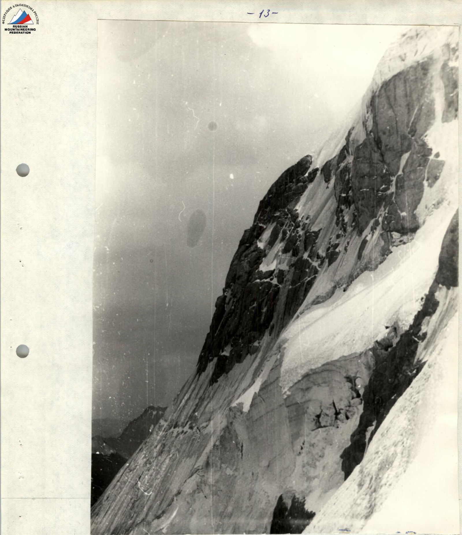
Profile of sections R0–R4. View from the saddle between the peaks Tekelik and Maly Tekelik.