
Ascent Passport
- Ascent class — rock climbing.
- Ascent area — Pamir-Alay, southern spurs of the Alay ridge, Kemisdykty glacier.
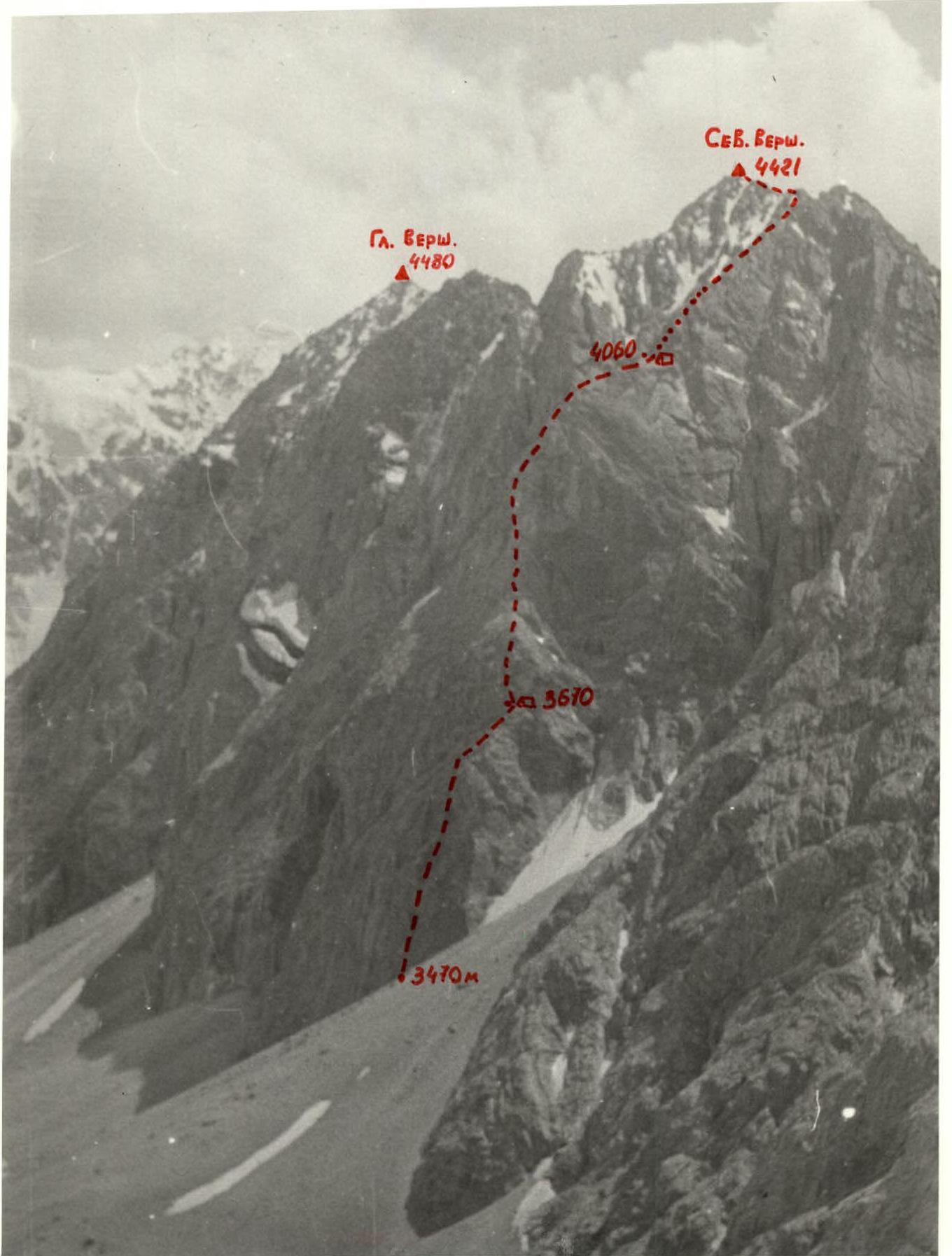
- Peak, its height, ascent route: peak Skalny North summit, 4421 m, via NNE edge.
- Expected difficulty category — 5B.
- Route characteristics: rock climbing. — height difference — 950 m, — average steepness: — wall part: 66°, — ridge part: 35°, — section length — 1210 m: — wall part: 660 m, — ridge part: 550 m.
- Pitons hammered:
| Category | For belay | For creating belay anchors |
|---|---|---|
| Rock | 87 | 12 |
| Bolt | — | 5 |
| Nut elements | 21 | 3 |
| Total | 108 | 20 |
- Number of climbing hours — 23 hours.
- Number of bivouacs and their characteristics: two bivouacs: — one in a comfortable cave (no water), — second on a shoulder under the summit (good platform).
- Surname, name, and patronymic of the team leader and participants, their sports qualification:
- Khokhlov Yuri Vladimirovich, Candidate Master of Sports, team leader.
- Shuvalov Vyacheslav Alexandrovich, Candidate Master of Sports
- Kravets Mikhail Borisovich, Candidate Master of Sports
- Pivnyak Vladimir Leontyevich, 1st sports category
- Skripko Vyacheslav Vitalyevich, 1st sports category
- Golovkin Nikolai Mikhailovich, 1st sports category
- Team coach Demchenko Alexander Stepanovich, Master of Sports of International Class.
- Date of departure and return: from August 11 to August 14, 1981.
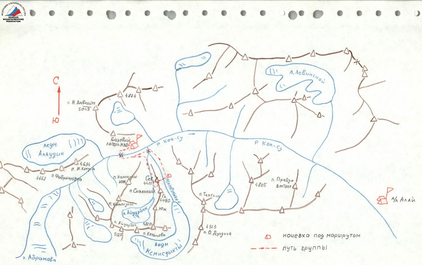
Ascent Area Diagram
 Legend:
— bivouac under the route
— group path
Legend:
— bivouac under the route
— group path
Skalny Peak Massif
The Skalny peak massif is located in the northern branch of one of the southeastern spurs of the Alay ridge, it is stretched in the meridional direction and separates the cirques of the Aydarbek and Kemisdykty glaciers.
The northern summit of the massif has a height of 4421 m, it is separated from the main summit by an extended ridge with several depressions. From the North summit, a Northeast ridge departs, which steeply descends and breaks off to the East and North with sheer walls. The junction of the Eastern and Northern walls forms a steep NNE edge.
The predominant rocks in the area are granites and marbles. The rocks of the NNE edge of peak Skalny North are partially composed of marbles and have a small number of cracks for pitons. The edge also features large areas of highly polished rocks resembling "sheep's foreheads". The rocks forming the edge are mainly monolithic, with almost no severely damaged areas or loose stones.
There is no information about ascents to the North summit of peak Skalny, and there are no classified routes.
The base camp of the MVO team in July 1981 was located on the left bank of the Kok-su river opposite the confluence of its tributary Kemisdykty.
The steep, sharply rising NNE edge of the North summit of peak Skalny immediately caught the attention of the team and the coaching staff. Its steep, sharply outlined profile and smooth, as if polished, North wall sparked a desire to get to know them better. Therefore, when choosing an ascent object in the rock climbing class of the Armed Forces championship, there were no disagreements. After repeated reconnaissance and observation, the route along the NNE edge was chosen as the most logical, interesting, and objectively safe, which was confirmed during the ascent. Moreover, the route presented a pleasant surprise. What seemed to be a small niche from below, suitable at best for a sitting overnight stay, turned out to be a very deep cave, above a person's height, which after 1.5 hours of work became a comfortable place to spend the night, protecting the entire team from the night thunderstorm and snowfall.
Overall, the route is rock climbing, with no water along its entire length. The peculiarity of the rocks on the route requires the group to have good rock climbing skills and the ability to use a wide range of nut elements, as well as bolt pitons.
Approach to the Route Description
From a sports perspective, the route is of significant interest for sports groups of sufficiently high qualification.
From the MVO training camp's base camp, located on the left bank of the Kok-su river opposite the confluence of its tributary Kemisdykty river, the path lies up the Kok-su gorge to the point where the Kok-su canyon narrows significantly (20 minutes). Then, across a stone plug in the canyon, you need to cross to the right bank of the river and go down the gorge to the point where the right tributary Kemisdykty river flows into it (20 minutes). After crossing to the right bank of the Kemisdykty river along a stone talus, enter the eponymous gorge and approach the green meadows opposite the Eastern wall of the North summit of peak Skalny (50 minutes). Here are convenient overnight stays for the group and observers. The approach from these overnight stays to the start of the route takes about 40 minutes.
Route Description
From the overnight stays under the route, cross the Kemisdykty river by stones or a snow bridge and ascend to the start of the NNE edge along a steep talus cone (30–40 minutes).
The lower part of the route passes slightly to the left of the edge itself along the edge of the Eastern wall. The start of the route is left-upward along an internal corner 40 m to a small ledge, where you can organize a belay anchor (R0–R1). Then upward 10 m under an overhang, then left-upward bypassing the overhang 10 m and 20 m along the internal corner to the next belay anchor and then 20 m to a small overhang (R1–R2). The wall with an overhang (R2–R3) 7–8 m is passed by complex climbing using ladders and artificial footholds, it leads to an inclined shelf (R3–R4) under a large overhang. On the shelf is the 1st control cairn. To the left, the shelf is bounded by a vertical black wall 15 m (R4–R5), highly polished and lacking cracks. The wall is passed by very complex climbing using ladders and bolt pitons. Sections R2–R3 and R4–R5 are passed with pulling up backpacks. The wall R4–R5 ends with a small ledge, from which an internal corner leads right-upward (75°) for 30 m (R5–R6). Climbing is complex. Then rightward 60 m along rocks resembling "sheep's foreheads" and talus inclined shelves — exit to the edge (R6–R7). Here, at the base of the second ascent of the NNE edge, a cave formed from a crack filled with rock debris. In it is the 1st overnight stay and the 2nd control cairn. Comfortable reclining overnight stay, but no water.
From the cave upward 20 m (R7–R8) under a steep chimney with a plug (R8–R9), difficult climbing up the chimney 40 m and then along steep polished rocks without cracks to the summit of the second ascent of the NNE edge 20 m (R9–R10). From here, approach the wall of the third ascent: first along talus shelves 40 m (R10–R11), then along destroyed rocks turning into a chimney onto a massive fragment under the wall of the third ascent (R11–R12). From the fragment — a wall 8 m (R12–R13) and a difficult exit to a small shelf, then straight upward onto a steep narrowing shelf leading left-upward (R13–R14). At the end of the shelf straight upward 15 m along a narrow crack (R14–R15) complex climbing onto steep shelves under an overhanging wall. Here the entire group can assemble. Along steep shelves 15 m straight upward (R15–R16) under an overhang and difficult traverse 15 m leftward behind the wall's bend (R16–R17). From here, a vertical crack goes straight upward. Very difficult climbing along a smooth, in the middle part overhanging, slab to the left of the crack (40 m) (R17–R18). The crack leads to a niche where you can organize a belay anchor. On R17–R18 — pulling up backpacks. Then leftward through a small wall into an internal corner 80 m (R18–R19). The internal corner leads to a steep ridge of the NNE edge (R19–R20), which after 80 m starts to flatten (R20–R21), forming a shoulder of the Northeast ridge of the North summit. Along talus shelves to the left of the ridge — exit to a platform on the shoulder. Here is a comfortable overnight stay, but no water. From the overnight stay, traverse leftward along wide talus shelves 80 m (R21–R22) and then right-upward 300–350 m along несложным скалам and talus shelves — exit under the summit (R22–R23) and then along medium-difficulty polished rocks 40 m — exit to the North summit of peak Skalny (R23–R24).
Descent from peak Skalny North
Descent along the ridge towards the Main summit of peak Skalny to a large, smooth, triangular gendarme on the ridge. Not reaching the gendarme — rappel 80 m rightward into a narrow stepped couloir, then 40 m sport climbing and along wide talus shelves 120 m — exit leftward onto the route 3B category of difficulty on the Main summit of peak Skalny and along it to the Aydarbek glacier. The descent took 5 hours. Return to the MVO base camp took 2 hours.
Route in UIAA Signs
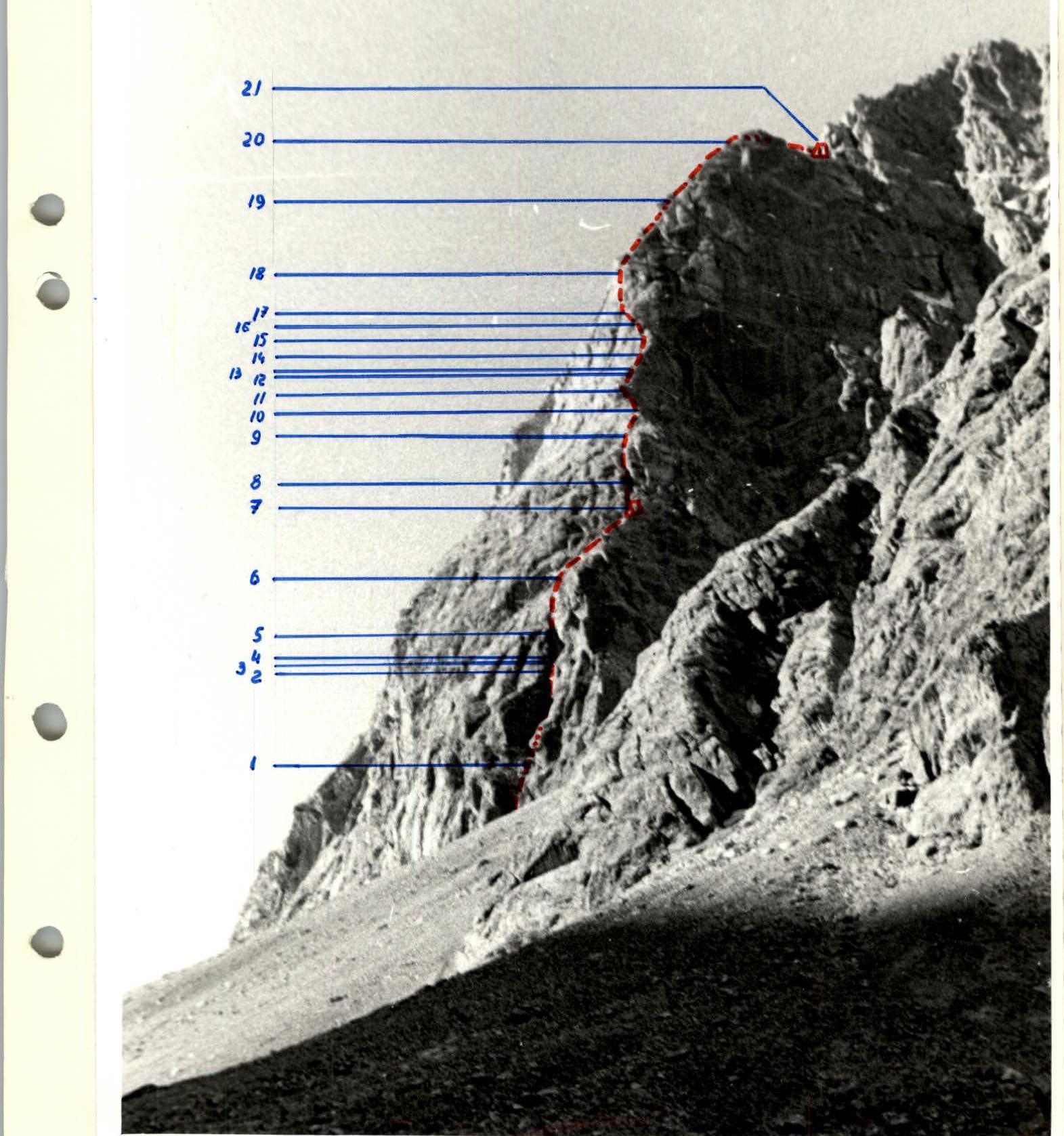
Wall Part of the Route
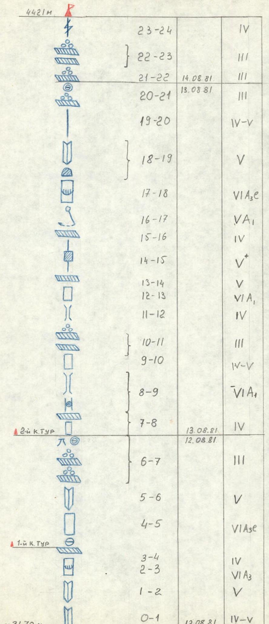
| Date | Designation of sections | Average steepness in degrees | Length in meters | Route character | Difficulty | Condition | Weather condition | Pitons hammered for belay | Pitons hammered for creating belay anchors | Time taken — stops for bivouac, climbing hours, bivouac conditions, etc. |
|---|---|---|---|---|---|---|---|---|---|---|
| Rock | Bolt | Nut elements | ||||||||
| 12.08.81 | R0–R1 | 65° | 40 | internal corner | IV–V | monolithic polished rocks | Variable weather. Route not lit by the sun. Night — thunderstorm. | 6 | — | 1 |
| R1–R2 | 70° | 60 | crack | V | -"– | 11 | — | 4 | ||
| R2–R3 | 90° | 7–8 | overhanging wall | VIA3 | -"– | 11 | — | 2 | ||
| R3–R4 | 40° | 7 | inclined shelf under an overhang | IV | -"– | 3 | — | 1 | ||
| R4–R5 | 85° | 15 | smooth wall | VIA3C | monolithic rock without cracks, to the right overhangs a cornice | — | — | — | ||
| R5–R6 | 75° | 30 | internal corner | V | polished rocks | — | — | — | ||
| R6–R7 | 40° | 60 | "Sheep's foreheads", inclined talus shelves | V | 4 | — | — | |||
| 13.08.81 | R7–R8 | 50° | 20 | walls, narrow shelves | IV and | large, unstable blocks lying on shelves | Variable weather. Route almost not lit by the sun. | — | — | 1 |
| R8–R9 | 65–70° | 40 | chimney with a plug | V–VIA | almost no cracks for pitons | 5 | — | — | ||
| R9–R10 | 60° | 20 | polished rocks | IV–V | ca | 5 | — | — | ||
| R10–R11 | 35° | 40 | talus shelves | V | 3 | — | — | |||
| R11–R12 | 50° | 40 | destroyed rocks | IV | — | — | — | |||
| R12–R13 | 80° | 8 | wall | VIA1 | highly polished rocks | — | 1 | — | ||
| R13–R14 | 60° | 20 | steep, inclined shelf | V | — | 1 | 2 | |||
| R14–R15 | 75° | 15 | crack | V | 2 | — | — | |||
| R15–R16 | 55° | 15 | steep shelves | IV | 5 | — | 1 | |||
| R16–R17 | 75° | 15 | traverse of the wall | VA1 | highly polished rocks | 3 | — | — | ||
| R17–R18 | 85–90° | 40 | vertical crack | VIA3C | very difficult, highly polished rocks, possible rockfall from above | 10 | — | 6 | ||
| R18–R19 | 60° | 80 | internal corner | V | 11 | — | — | |||
| R19–R20 | 45–50° | 80 | ridge of the counterfort | IV–V | "live" stones | 9 | — | — | ||
| R20–R21 | 35° | 80 | talus shelves along the ridge | V | destroyed rocks | — | — | — | ||
| 14.08.81 | R21–R22 | 35° | 80 | talus shelves | V | rockfall hazardous | Good weather | — | — | — |
| R22–R23 | 35° | 300–350 | -"– | V | — | — | — | |||
| R23–R24 | 50° | 40 | wall | IV | — | — | 3 |
Total: 23 climbing hours
Route Recommendations
The passed route can be recommended for a well-prepared sports group of 2–4–6 people. Vibram-type boots for all group members and galoshes for the first climber are necessary. Various pitons were used on the route, but having a set of channel pitons and nut elements in the group can be recommended. Having bolt equipment and ladders is necessary. Deteriorating weather on the route may require more bolt pitons.
Climbers should also keep in mind that there may be no water on the route up to the summit, and even on the descent during the hot season.
Overnight stays, besides the noted ones, are possible on the summits of the edge's ascents, but only sitting and semi-sitting.
Route Conclusions
The route to the North summit of peak Skalny is purely rock climbing. The wall part of the route is a чередование monolithic and polished rocks of V–VI difficulty categories. Passing certain sections requires artificial footholds. Two sections are passable only with the use of bolt technique. In several places, pulling up backpacks is necessary. Throughout the wall part, the first climber needs to wear galoshes and climb without a backpack.
The route's passage is also complicated by the lack of water on it.
The route is logical, interesting, and objectively safe. The passage of this route by the MVO team in the Armed Forces championship was awarded a gold medal in the rock climbing class.
Team leader, Candidate Master of Sports Yu. V. Khokhlov
Comments
Sign in to leave a comment