Ascent Log
To the summit of Peak Solieva (4770 m) via the Northwest Ridge.
-
Ascent category: technical.
-
Ascent area: Alai Range, Kok-Su gorge.
-
Peak: Peak Solieva (4770 m) via the Northwest Ridge.
-
Estimated difficulty category — 3B.
-
Route characteristics:
elevation gain — 750 m; section lengths: 5th cat. diff. – 30 m, 4th cat. diff. – 20 m, 3rd cat. diff. – 350 m; average slope — 30°.
-
Pitons used for protection:
rock — 9, ice — none, bolt — none.
-
Total climbing hours: 15 hours (from camp to camp).
-
Number of nights and their characteristics — none.
-
Group composition:
Alekseev A.V. — 1st sports category. Malinovsky A.I. — 1st sports category.
-
Team coach:
Ekimov S.M. — Master of Sports.
-
Date of departure and return:
July 24, 1978 4:00–19:00.
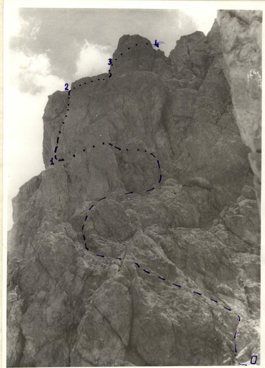 Q.2. The wall with a chimney — view from the saddle.
Route Description
Ascent to Peak Solieva (4770 m) via the Northwest Ridge.
From the camp located at the Kozhdeba clearing, ascend along the left orographic bank of the Koshka-Su River. Then follow the left bank of the stream flowing from the cirque of Peak Solieva. At the confluence of the stream and the Koshka-Su River, there's a convenient bivouac site. Moving along the moraines and bypassing the Southwest Ridge, reach the scree couloir leading to the saddle in the Northwest Ridge (4 hours from the Kozhdeba clearing, 1 hour from the bivouac at the confluence). Ascend to the saddle via the right (uphill) side of the couloir, bypassing a rock plug with flowstone on the rocks (1.5 hours). From the saddle, ascend via heavily broken rocks of moderate difficulty (rockfall hazard!) to a vertical wall on the left (35 m), cut by a crack turning into a chimney with two plugs and filled with flowstone (very difficult climbing, piton protection!). Then follow easy rocks to the left towards a wall (20 m, 70°) with good holds but no cracks for pitons. Climb the wall straight up and then via simple ridge rocks, on which there are 5 gendarmes. The first gendarme is bypassed via scree shelves on the right, the second — via a smooth inclined shelf on the left, the rest — via rocks of moderate complexity head-on. From the fifth gendarme, make a sporty descent (15 m) under the summit tower and then ascend to the summit via simple rocks (4 hours from the saddle). Descend via the ascent route (2.5–3 hours to the saddle). Down the wall with the chimney — rappel (40 m). From the saddle, down the couloir and then to the camp (2 hours).
Overall route characteristics. Total elevation gain — 1300 m, including 750 m along the rocky ridge. Section lengths: 5th cat. diff. – 30 m, 4th cat. diff. – 20 m. Average slope — 30°. Pitons used for protection: rock — 9, ice — none, bolt — none. Total climbing hours for ascent — 9.5 hours, for descent — 5 hours, total — 15 hours.
Table of Main Route Characteristics
| № | Section | Section Characteristics | Slope | Length | Protection | Pitons |
|---|---|---|---|---|---|---|
| 1. | O–I | Easy rocks | 40° | 120 | Rock features | — |
| 2. | I–2 | Wall with chimney | 70–80° | 35 | Pitons | 6 |
| 3. | 2–3 | Easy rocks | 30° | 50 | Rock features | — |
| 4. | 3–4 | Wall | 70° | 20 | Pitons, features | 2 |
| 5. | 4–5 | Rocky ridge | 30° | 500 | Rock features | — |
| Fifth gendarme (descent) | 60° | 15 | Pitons | 1 | ||
| 6. | 5–6 | Summit tower | 50° | 40 | Rock features | — |
September 2, 1978