Ascent Passport
- Ascent class — technical
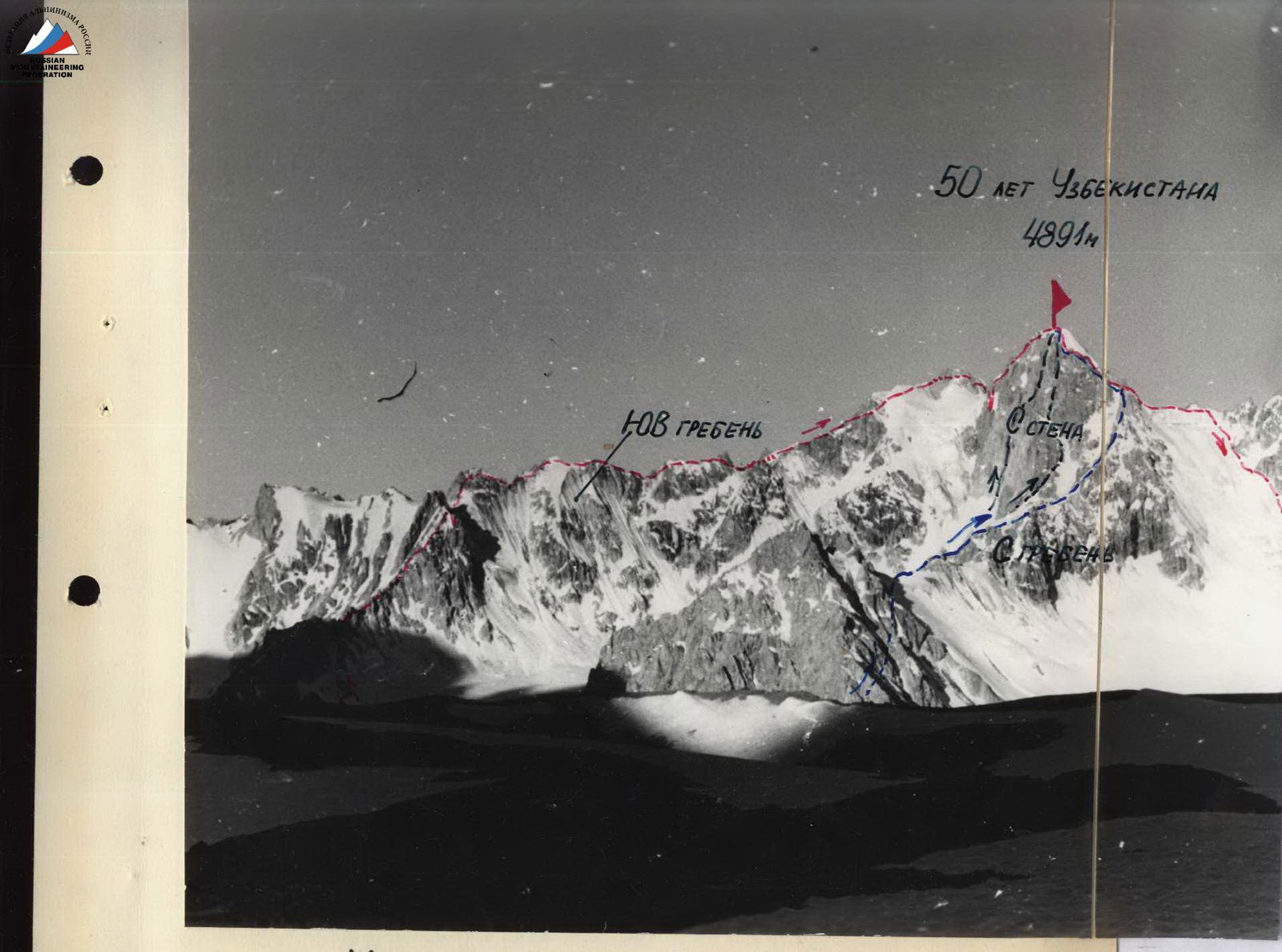
- Ascent area, ridge — Pamir-Alai, southern spurs of the Alai ridge, Levin's glacier
- Peak, its height, ascent route: 50 years of Uzbekistan, via the SE ridge, 4891 m
- Proposed category of difficulty — 5A
- Route characteristics: height difference — 1300 m, length of sections of category V difficulty — 430 m, average steepness — 40°
- Pitons hammered: rock — 49, ice — 3, bolted — none
- Number of climbing hours — 11.5
- Number of nights on the route: the route was completed without overnight stays, there are places on the route for organizing semi-reclined overnight stays
- Full name of participants, their qualification:
- Akhtyrchenko G.V., Candidate for Master of Sports
- Melentyev V.I., Candidate for Master of Sports
- Coach — Naumov A.F.
- Date of departure and return: July 7, 1978

Massif of Peak 50 years of Uzbekistan
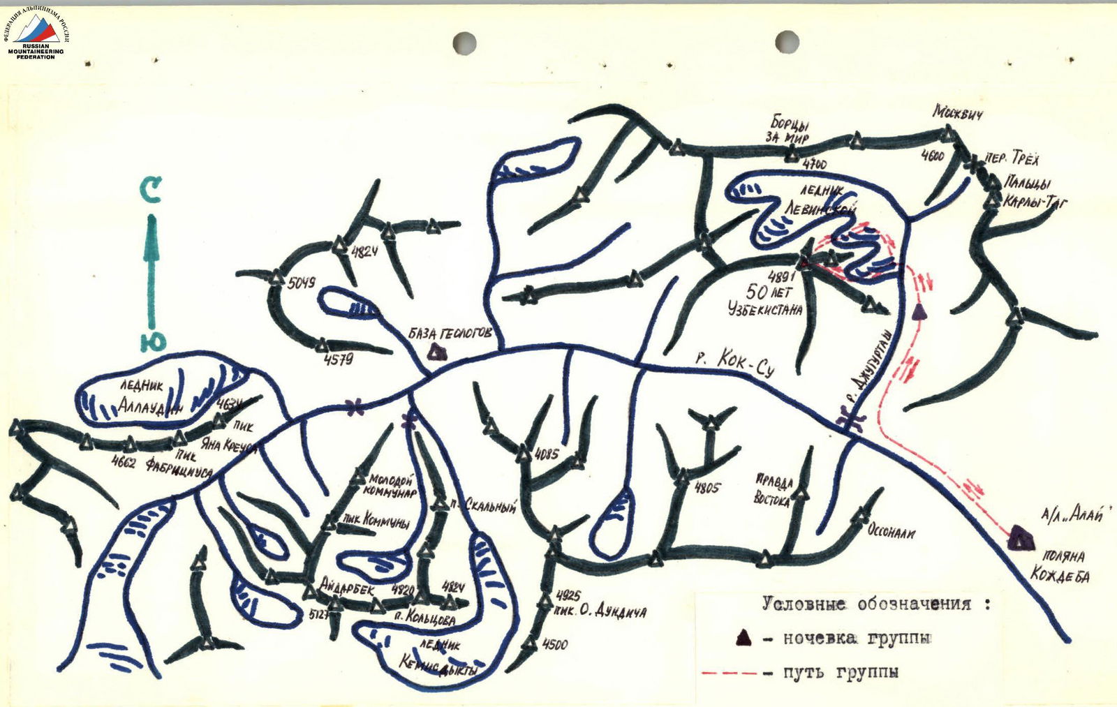
Sketch map of the ascent area
Route to Peak 50 years of Uzbekistan
Brief description of the approach to the route
From the base camp on Kozhdeba clearing, go up along the left (orographic) bank of the Kok-Su river, 2–2.5 hours. At the confluence of the Jugurtash river, turn right (in the direction of travel) and go through a large hill into the Jugurtash gorge. Go to the characteristic narrowing of the gorge. Here, in a small stony valley, are the overnight stays. From the turn into the Jugurtash gorge, it takes 1.5–2 hours.
From the overnight stays, go a little up the Jugurtash river gorge and turn left (in the direction of travel) into the lower cirque of Levin's glacier. Approach the route.
The approach from the overnight stays to the route takes 2 hours.
Table of route sections
Departure time from overnight stay — 5:20. Time of approach to the route — 7:00.
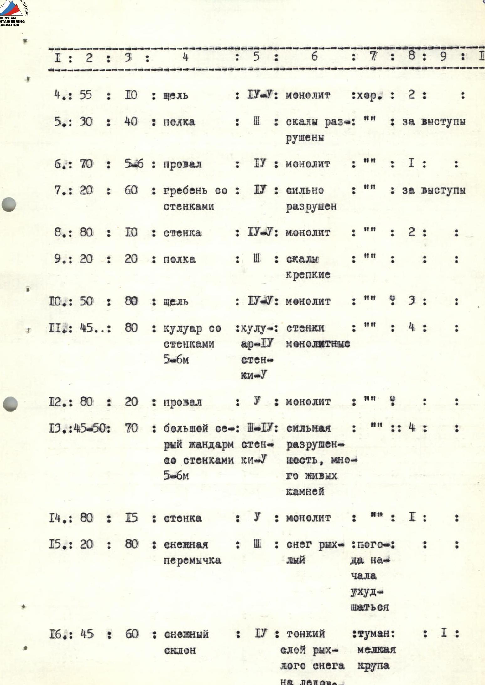
| Section # | Average steepness, degrees | Length, m | Terrain characteristics | Category of difficulty | Condition | Weather conditions | Pitons hammered (rock / ice / bolted) |
|---|---|---|---|---|---|---|---|
| R1 | 40 | 80 | snow slope | 2 | loose soft snow on a scree slope | good | |
| R2 | 45 | 80 | rocks | 3–4 | rocks are destroyed | 4 | |
| R3 | 15–20 | 80 | ridge | 2 | ridge with destroyed pinnacles | around protrusions | |
| R4 | 55 | 10 | crack | 4–5 | monolith | good | 2 |
| R5 | 30 | 40 | ledge | 2 | rocks are destroyed | ||
| R6 | 70 | 5–6 | gap | 4 | monolith | 1 | |
| R7 | 20 | 60 | ridge with walls | 4 | heavily destroyed | around protrusions | |
| R8 | 80 | 10 | wall | 4–5 | monolith | 2 | |
| R9 | 20 | 20 | ledge | 2 | rocks are strong | ||
| R10 | 50 | 80 | crack | 4–5 | monolith | 3 | |
| R11 | 45 | 80 | couloir with 5–6 m walls | couloir 5, monolith walls 5 | monolith | 4 | |
| R12 | 80 | 20 | gap | 5 | monolith | ||
| R13 | 45–50 | 70 | large gray pinnacle with 5–6 m walls | 3–4 | strong destruction, many loose rocks | 4 | |
| R14 | 80 | 15 | wall | 5 | monolith | 1 | |
| R15 | 20 | 80 | snow col | 2 | snow is loose | weather started to deteriorate | |
| R16 | 45 | 60 | snow slope | 4 | thin layer of loose snow on ice-firn substrate | fog, light graupel | |
| R17 | 60 | 15 | crack | 5 | monolith | 4 | |
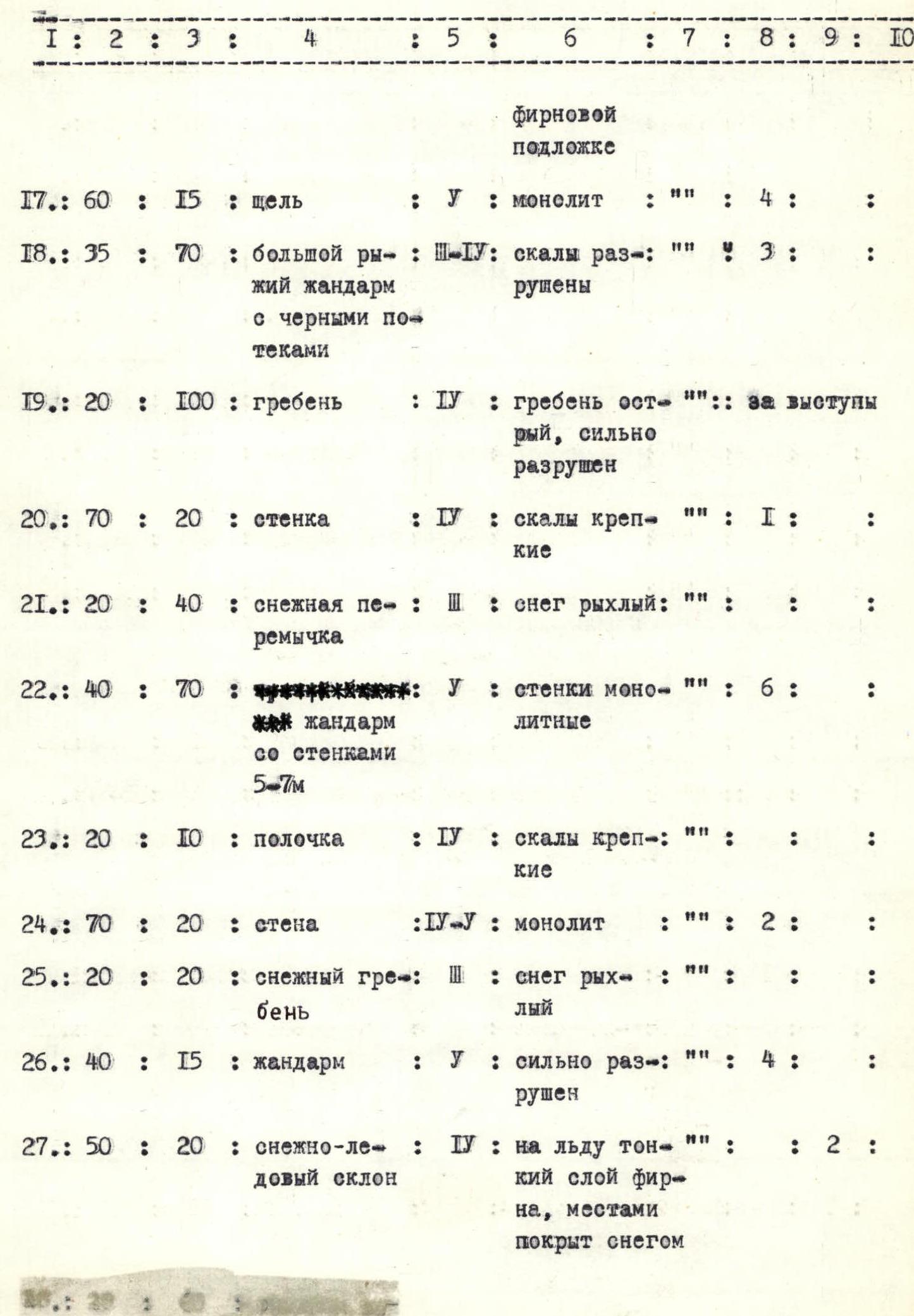
| R18 | 35 | 70 | large red pinnacle with black streaks | 3–4 | rocks are destroyed | 3 | |
| R19 | 20 | 100 | ridge | 4 | ridge is sharp, heavily destroyed | around protrusions | |
| R20 | 70 | 20 | wall | 4 | rocks are strong | 1 | |
| R21 | 20 | 40 | snow col | 3 | snow is loose | ||
| R22 | 40 | 70 | pinnacle with 5–7 m walls | 5 | walls are monolith | 6 | |
| R23 | 20 | 10 | small ledge | 4 | rocks are strong | ||
| R24 | 70 | 20 | wall | 4–5 | monolith | 2 | |
| R25 | 20 | 20 | snow ridge | 3 | snow is loose | ||
| R26 | 40 | 15 | pinnacle | 5 | heavily destroyed | 4 | |
| R27 | 50 | 20 | snow-ice slope | 4 | ice with a thin layer of firn, partially covered with snow | 2 | |
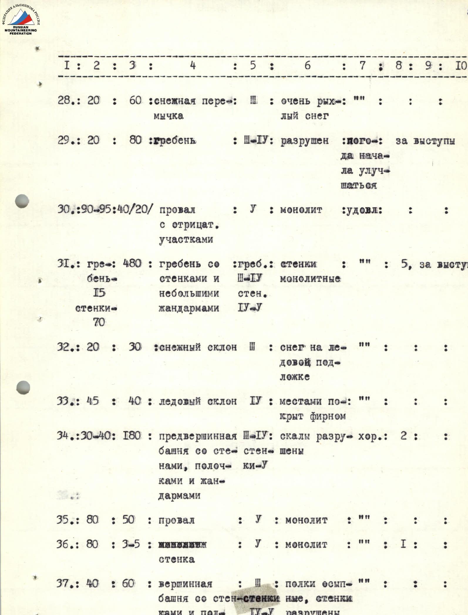
| R28 | 20 | 60 | snow col | 3 | very loose snow | ||
| R29 | 20 | 80 | ridge | 3–4 | destroyed | weather started to improve | |
| R30 | 90–95 | 40/20 | gap with negative sections | 5 | monolith | satisfactory | |
| R31 | ridge | 480 | ridge with 15 m walls and small pinnacles, 70 m walls | 3–4 | monolith walls | 5 | |
| R32 | 20 | 30 | snow slope | 3 | snow on ice substrate | ||
| R33 | 45 | 40 | ice slope | 4 | partially covered with firn | ||
| R34 | 30–40 | 180 | pre-summit tower with walls, ledges, and pinnacles | 3–4 | rocks are destroyed | good | 2 |
| R35 | 80 | 50 | gap | 5 | monolith | ||
| R36 | 80 | 3–5 | wall | 5 | monolith | 1 | |
| R37 | 40 | 60 | summit tower with walls and ledges | 3–4 | ledges are scree, walls are destroyed |
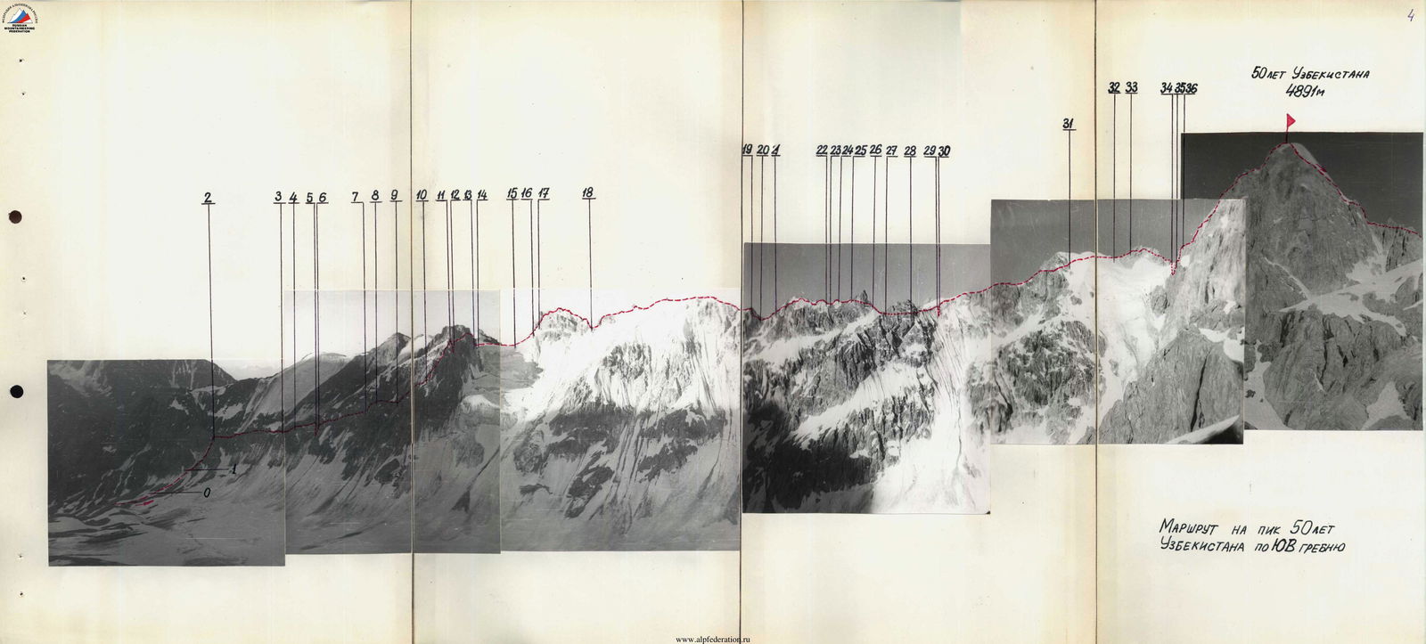
Ascent to the summit — 18:20. Descent started — 18:30. Climbing hours — 11 hours 30 minutes.
Descent from the summit takes 2 hours 30 minutes. Duration of the route from overnight stays to overnight stays — 17 hours. Route length — 2200 m.
Brief explanation of the route sections table
The approach from the overnight stays on the bank of the Jugurtash river to the route takes 1–1.5 hours, via scree and glacier.
The route begins with an ascent to the SE ridge to the left of two pinnacles (humps), 7–8 m and 5–6 m. Here, a control cairn is constructed.
Further, the path goes along the SE ridge. The entire ridge is heavily destroyed. Many loose rocks.
It is necessary to: — proceed with maximum caution!
After ascending to the ridge, a simple traverse follows to the left along scree ledges (R3).
Then, through a crack (R4) with difficult climbing — exit to a ledge (R5). A small gap (R6) is passed by climbing. The ridge (R7) is traversed to the left. After a difficult wall (R8), along a ledge (R9) — exit to a long crack (R10), turning into a couloir (R11). The crack is passed with difficult climbing, partly on abutments. Sharp small pinnacles (prongs) are bypassed along 4–6 m walls on the right side of the couloir. Leaving a pinnacle on the right at the top of the couloir, exit to a gap (R12). Descent into the gap — by sports method.
A large gray pinnacle (R13) is bypassed along difficult 5–6 m walls on the right. Descent from the pinnacle along a 15 m wall (R14). Then, passage along a snow col (R15) and ascent along a snow slope (R16). Along a difficult crack (R17), exit to a red pinnacle with black streaks (R18).
The pinnacle (R18) is traversed on top, partly traversed almost at the very top.
Caution, cornices!
A long ridge (R19) is traversed on top. The ridge is sharp and heavily destroyed.
Pinnacle (R22) is traversed along difficult walls on the right.
A small, very destroyed pinnacle (R26) is bypassed on the left. Along a snow-ice slope (R27) and a snow col (R28), exit to a rocky ridge (R29). The ridge is traversed on top. The ridge is cut by a long narrow gap 40 m (R30) with negative sections. Descent into the difficult gap by "dülfer" rappel for 20 m with exit to a small ledge on the opposite wall.
Further — along a long ridge (R31) with small difficult walls and pinnacles. Walls are overcome by climbing, pinnacles are bypassed on the left.
The pre-summit tower (R34) is traversed along difficult walls and ledges, leaving small pinnacles on the right.
Between the pre-summit and summit towers, there is a 50 m gap (R35). Descent into the gap by sports method. Exit from the gap: — left along a difficult small wall (R36).
Ascent to the summit — along scree ledges and difficult destroyed walls.
Descent from the route
Descent — towards the middle cirque of Levin's glacier, leaving the S ridge (route 4A category of difficulty) on the right (in the direction of travel). First, descend along destroyed walls and scree slopes. During the descent, 4 sports rappels are organized, 30–40 m each.
Then, exit to a snow col, leaving a rocky outcrop on the left, descend down a steep snow-ice slope. Then, go down along Levin's glacier to the Jugurtash river. Descent takes 2 hours 30 minutes.
Descent is possible along steep scree slopes — through the gorge, exiting into the Kok-Su river valley.
List of equipment, clothing, footwear
- Various rock pitons — 15 pcs. / 1 kg
- Channel pitons — 6 pcs. / 0.5 kg
- Rock hammer — 1 pc. / 0.6 kg
- Titanium carabiners — 12 pcs. / 1.5 kg
- Ladders — 2 pcs. / 0.5 kg
- Main rope — 1 × 40 m / 2.5 kg
- Auxiliary cord — 15 m / 0.3 kg
- Down jacket — 2 pcs. / 1.6 kg
- Crampons — 2 pairs / 5 kg
- Galoshes — 1 pair / 0.3 kg
- R/station "Vitalka" — 1 pc. / 0.6 kg
- Food — set / 0.8 kg
- Drinking water — 1 l / 1 kg
- Helmet — 2 pcs. / 0.8 kg
- Ice axe, ice hammer — 1 + 1 pc. / 3 kg
Total: 19.7 kg
Recommendations for the route
For a group of 4–6 people, the route is recommended to be completed with an overnight stay. In the upper part of the route, there are places on scree ledges and snow slopes where semi-reclined overnight stays can be organized.
In the second half of summer, descent from the summit is recommended through the gorge, exiting into the Kok-Su river valley — due to the high steepness and fragmentation of the snow-ice slope descending from the col to Levin's glacier.
Conclusions on the route
The route to Peak 50 years of Uzbekistan via the SE ridge was first ascended on July 7, 1978, by a pair:
- Akhtyrchenko G.V., Candidate for Master of Sports
- Melentyev V.I., Candidate for Master of Sports
The route is similar in character to the route to Peak Uilpata via the 2nd buttress of the S ridge, 5B category of difficulty (route by M. Konkov).
The first ascenders have 9–13 ascents of category 5 difficulty and believe that the route to Peak 50 years of Uzbekistan via the SE ridge corresponds to 5A category of difficulty.
First ascenders: