Ascent Log
- Climbing category — technical.
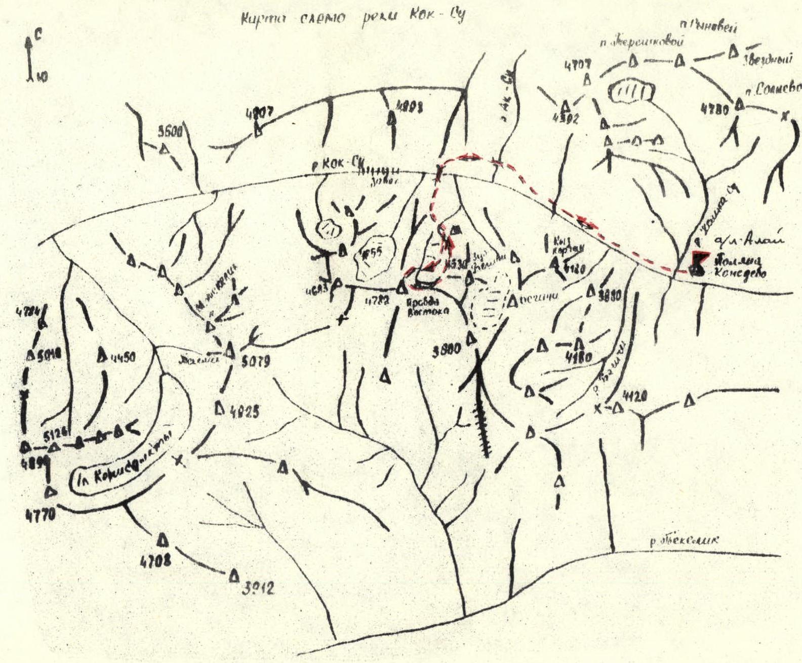
- Climbing region — Pamir, Pamir-Alay, Alay Range, Koksu valley.
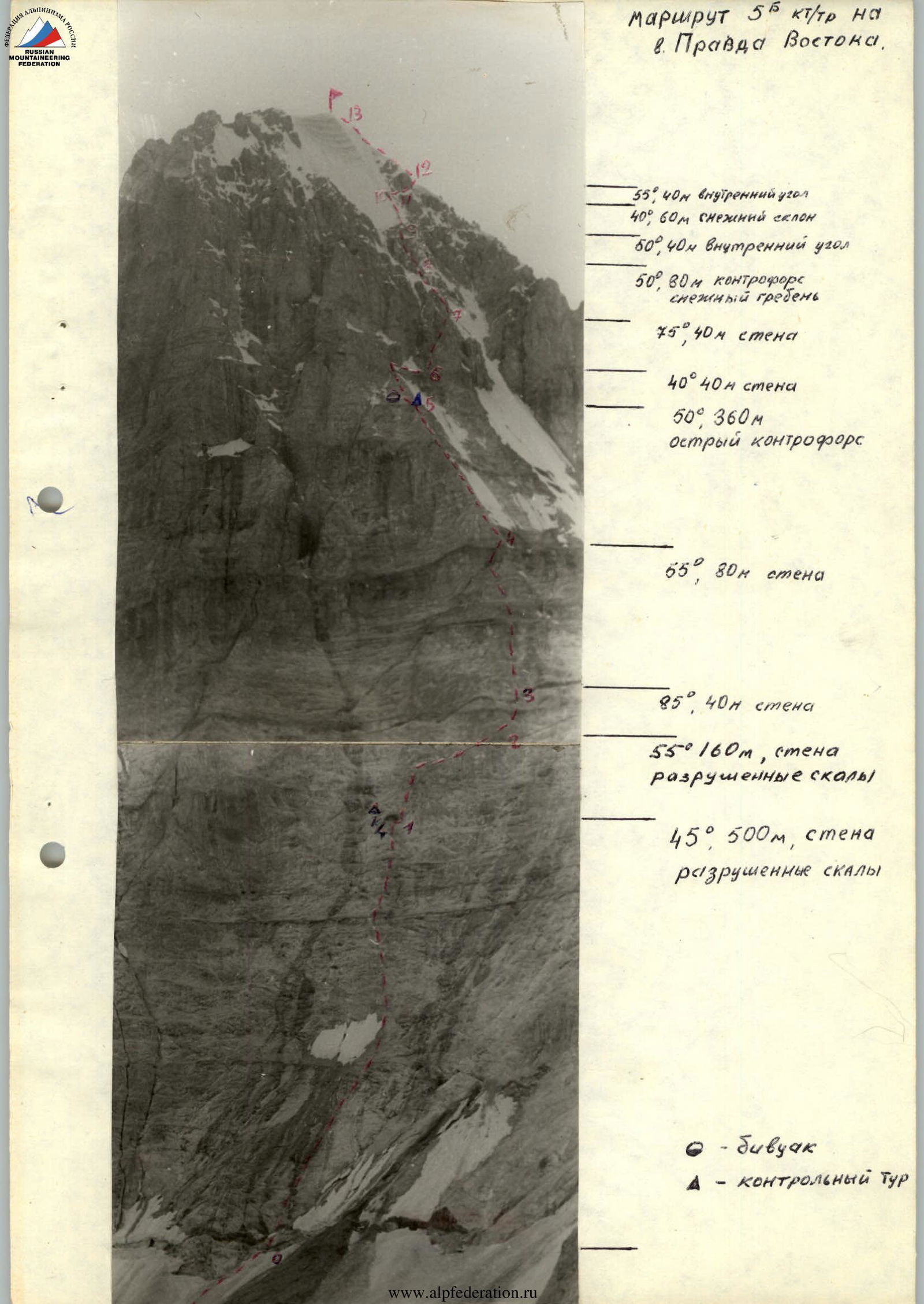
- Peak, its height, ascent route — Pravda Vostoka, 4950 m, via the center of the Northeast face with an exit to the North counterfort.
- Expected difficulty category — 5B.
- Route characteristics: elevation gain — 970 m, length of 5th category difficulty sections — 760 m, average steepness — 55°.
- Number of pitons: for belaying, for artificial climbing anchors: rock — 114, ice — 3, bolt —.
- Number of climbing hours — 23.
- Number of bivouacs and their characteristics — one bivouac, sitting.
- Climbing leader — Yankovsky Vladimir Ilyich — Candidate Master of Sports. Team members: Yankovsky Alexander Ilyich — Candidate Master of Sports, Burkhanov Viktor Alekseevich — Candidate Master of Sports, Tselishchev Sergey Alekseevich — Candidate Master of Sports.
- Team coach — Teplyakov Pavel Kirillovich — Master of Sports.
- Date of ascent (exit to the route) — August 13, 1981. Date of return to base camp — August 15, 1981.
Brief description of the approach to the route
From the base camp at Kozhdeba meadow, along the orographic left bank of the Koksu river, move to the crossing near the geologists' base (2–3 h). Cross to the right bank of the Koksu river via the bridge near the geologists' base, then:
- ascend via green fields and small scree in the direction of the Shahdar glacier's moraine deposits.
At the boundary between the green fields and moraine deposits — a lake. Convenient bivouac sites are available near the lake. (To the lake — 1–1.5 h).
From the bivouac:
- move via the Shahdar glacier's moraine deposits in the direction of Pravda Vostoka peak to approach the central part of the Northeast face (1 h).
The start of the route is between two snow cones, which have numerous rocks.
Route description
From the bivouac near the lake, ascend via the Shahdar glacier's moraine deposits towards the Northeast face of Pravda Vostoka peak (1 h).
Between the snow cones, climb directly up the face's destroyed rocks in the direction of a clearly visible "hole". Be cautious — loose rocks!
To the "hole" from the start of the route — 500 m, 4 h.
In the "hole" — the first control point (bivouac possible).
Further, to the right of the "hole", move via the face's destroyed rocks towards the "red finger", 120 m — exit to a 40-meter wall (destroyed wet rocks, key location). Above the wall — an inclined scree ledge. From the ledge, ascend to an inner corner. Via the corner — exit to the "red finger" — 80 m.
From the "finger", ascend the sharp North counterfort — 320 m, exit to a scree ledge. Bivouac! Second control point. From the first control point to the second — 10 h.
From the bivouac, ascend the counterfort — 40 m to a нависающую стену. Further, traverse right via steep rocks with ice coatings to an inner corner. Up the right side of the inner corner — 40 m — exit to a ledge (key location). Via the sharp counterfort — 40 m and further via a snowy ridge — 40 m — exit to an inner corner with ice coatings. Via the inner corner — exit to a snow-ice slope (key location). Traverse right and upwards via a snow-ice slope with rock outcrops — exit to the pre-summit ridge, 180 m. When exiting to the ridge, overcome a snow cornice. Further via a gentle snowy ridge — exit to Pravda Vostoka peak, 60 m. From the second control point to the summit — 9 h.
Descent from the summit via the East ridge to bivouac sites.
- Loop. Rappelling — 30 m.
- Loop. Rappelling — 40 m.
- Via the East ridge's counterfort rocks — 40 m.
- Loop. Rappelling — 40 m.
- Loop. Rappelling — 40 m.
Exit to a couloir leading to the Shahdar glacier. Via the left side of the couloir — 230 m, further via scree — exit to the Shahdar glacier. Via the glacier, keeping to the right side, further via moraine deposits — exit to bivouac sites near the lake.
Table of main characteristics of the ascent route
Table I
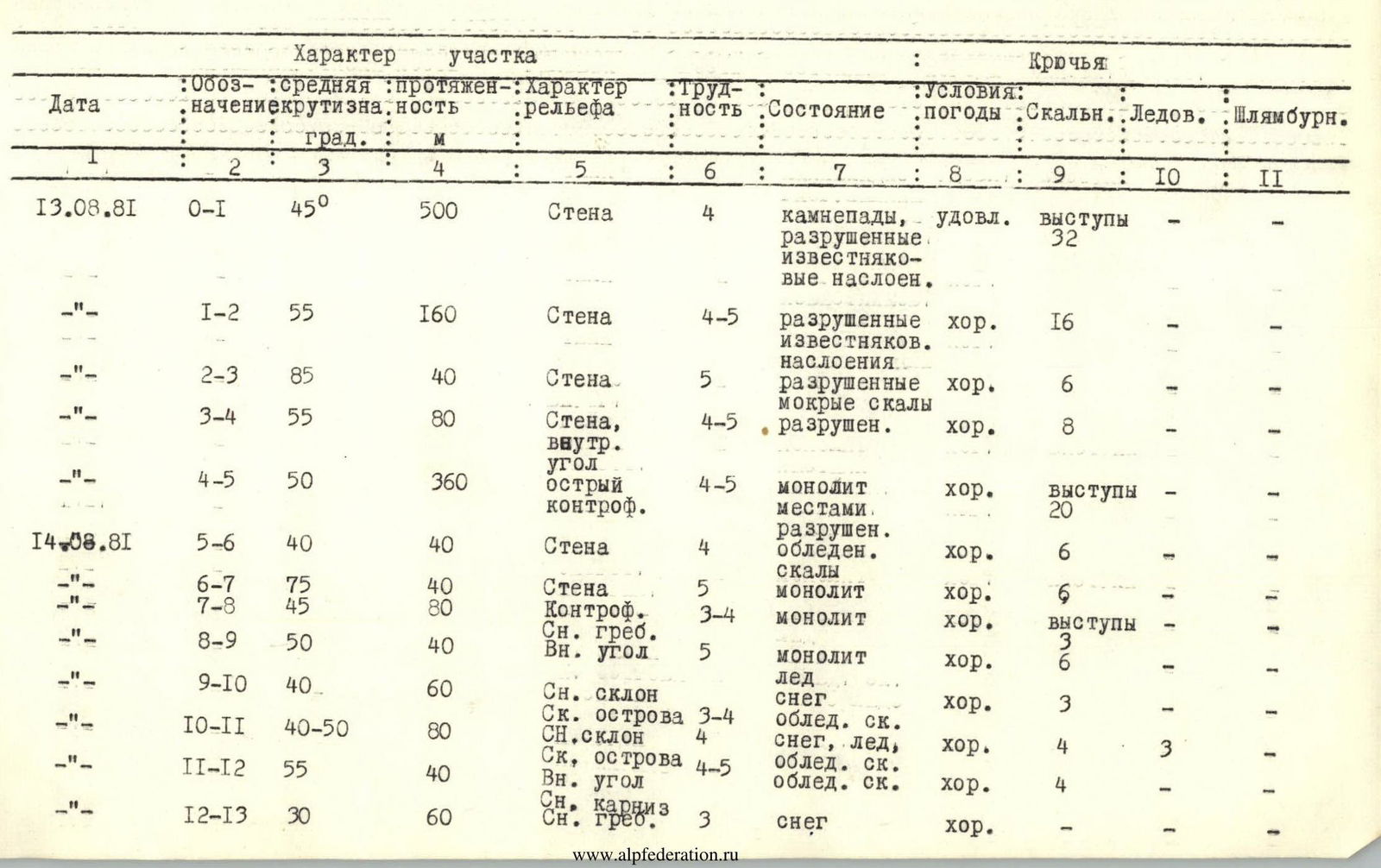
| Date | Designation | Average steepness | Length | Terrain characteristics | Difficulty | Condition | Weather conditions | Rock | Ice | Bolt |
|---|---|---|---|---|---|---|---|---|---|---|
| August 13, 1981 | R0–R1 | 45° | 500 m | Wall | 4 | destroyed limestone layers | rockfall, satisfactory | 32 | — | — |
| R1–R2 | 55° | 160 m | Wall | 4–5 | destroyed limestone layers | good | 16 | — | — | |
| R2–R3 | 85° | 40 m | Wall | 5 | destroyed wet rocks | good | 6 | — | — | |
| R3–R4 | 55° | 80 m | Wall, inner corner | 4–5 | destroyed | good | 8 | — | — | |
| R4–R5 | 50° | 360 m | Sharp counterfort | 4–5 | monolith, partially destroyed | good | 20 | — | — | |
| August 14, 1981 | R5–R6 | 40° | 40 m | Wall | 4 | icy rocks | good | 6 | — | — |
| R6–R7 | 75° | 40 m | Wall | 5 | monolith | good | 6 | — | — | |
| R7–R8 | 45° | 80 m | Counterfort, snowy ridge | 3–4 | monolith | good | 3 | — | — | |
| R8–R9 | 50° | 40 m | Inner corner | 5 | monolith, ice | good | 6 | — | — | |
| R9–R10 | 40° | 60 m | Snowy slope | 3 | snow | good | 3 | — | — | |
| R10–R11 | 40–50° | 80 m | Rock outcrops, snowy slope | 3–4 | snow, ice, icy rocks | good | 4 | 3 | — | |
| R11–R12 | 55° | 40 m | Rock outcrops, inner corner | 4–5 | icy rocks | good | 4 | — | — | |
| R12–R13 | 30° | 60 m | Snow cornice, snowy ridge | 3 | snow | good | — | — | — |
Brief explanation
SECTION R0–R1. Wall 45°, 500 m. Destroyed rocks. Rockfall possible! Recommended to pass before 8:00. Movement in the lower section (120 m) is simultaneous. Piton belay.
SECTION R1–R2. Wall 55°, 160 m. Destroyed rocks with limestone layers. Carefully choose locations for piton placement.
SECTION R2–R3. Key wall 85°, 40 m. Wet rocks. Limestone. Limited hand and footholds and cracks for piton placement. Leads to an inclined scree ledge. Possible to clear rocks with a rope!
SECTION R3–R4. Wall 55°, 50 m. Exit to an inner corner. Inner corner 30 m leads to the "red finger". Climbing 4–5 category difficulty. Hazards:
- many loose rocks
SECTION R4–R5. Sharp counterfort 50°, 360 m. Monolith, partially destroyed. Belay — rock outcrops, pitons. Leads to a ledge suitable for bivouac. No platforms for gathering more than two people on the counterfort.
SECTION R5–R6. Wall 40°, traverse right 40 m. Steep rocks with ice coatings. Piton belay.
SECTION R6–R7. Wall 75°, 40 m. Monolith. Piton belay. Right side of the inner corner with ice coatings.
SECTION R7–R8. Counterfort 50°, 40 m. Monolith. Transitions to a snowy ridge 35°, 40 m. Belay — rock outcrops, pitons.
SECTION R8–R9. Inner corner with ice coatings 50°, 40 m. Monolith, ice. Piton belay.
SECTION R9–R10. Snowy slope 40°, 60 m. Rock outcrops. Rocks with ice. Belay — rock outcrops, pitons.
SECTION R10–R11. Snow-ice slope 40–50°, 80 m. Rock outcrops. Rocks with ice. Belay — ice screws, rock outcrops.
SECTION R11–R12. Inner corner with ice coatings 55°, 40 m. Exit to the ridge via a snow cornice. Piton belay.
SECTION R12–R13. Snowy ridge 30°, 60 m.
Footnotes
-
6 — control point ↩