
Ascent Passport
I. Ascent class — technical 2. Ascent area — Pamir-Alay, Alay ridge, Kок-Су gorge. 3. Peak, its height, ascent route — «Pravda Vostoka», 4950 m, via the North-Eastern wall 4. Difficulty category — 5B 5. Route characteristics: height difference — 1100 m, length of 5–6 cat./tech. sections — 900 m, average steepness — 70°. 6. Pitons hammered for belay: rock — 132 pcs., ice — 18 pcs., bolt — 8, chocks — 16; for creating I.T.O. — 2 rock pitons. 7. Number of climbing hours — 30 h 8. Number of nights — one bivouac 9. Team composition:
leader Tenigin B.Ya. — CMS
- Sirenkov P.A. — CMS
- Panteleev B.L. — CMS
- Barchuk A.N. — CMS
- Klovanich S.F. — CMS
- Solomonov A.I. — CMS
- Team coach — Solomonov A.I.
II. Date of departure on the route August 16, 1981, date of return — August 18, 1981.
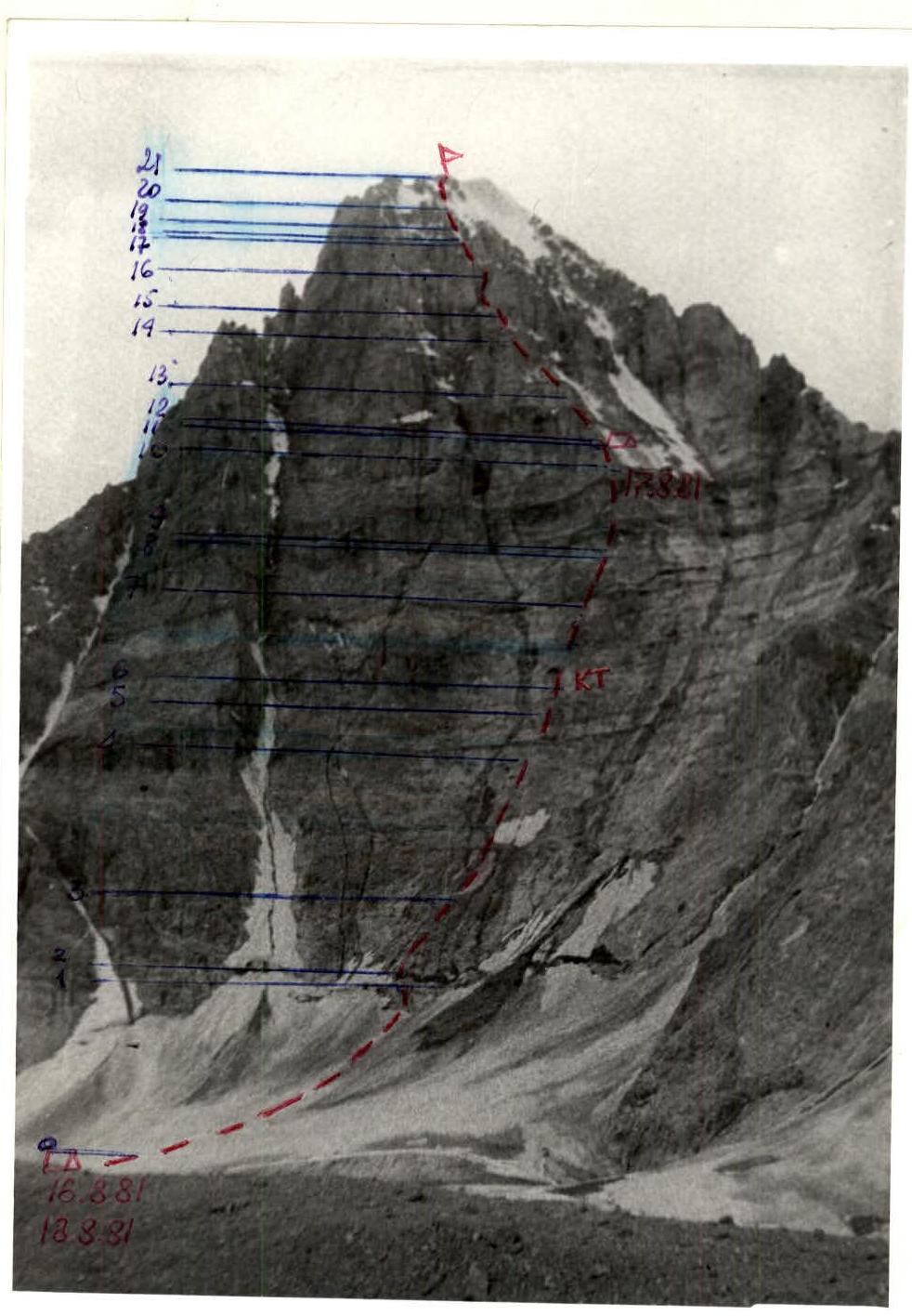
TABLE of main characteristics of the ascent route
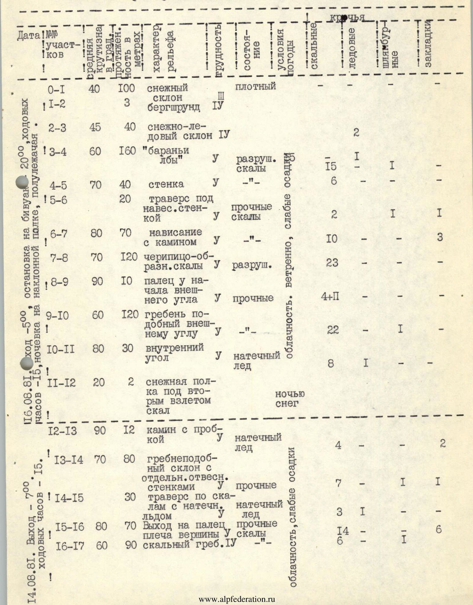
Brief explanation of the table
From Kozhdeba clearing up the Kок-Су river 2 h 30 min to the geologists' base. Crossing the river by bridge, up under the slopes of Kyz-Korgon along the stream — 1 h 30 min. On the moraine, overnight stays by the lake. From overnight stays 1 h to the start of the route.
R0–R1: Snow slope from the foot of the peak to the bergschrund at the base of the wall. To the left of the talus cone — exit to the bergschrund.
R1–R2: Due to the absence of snow bridges, the bergschrund is overcome along the wall using ice equipment.
R2–R3: To the left of the boundary of rock outcrops — ascent on ice to the rocks.
R3–R4: Rocks of the "ram's forehead" type in the direction of the gyrot in the lower third of the wall.
R4–R5: To the left of the streaks — up the sheer wall. The first goes in galoshes.
R5–R6: Ascent under the overhanging "black wall". Difficult traverse to the right under the overhanging rocks to the vertical crack.
R6–R7: Up the crack turning into a chimney with a cork — very difficult climbing. The cork is passed using chocks.
R7–R8: Along karst, tile-structured rocks — up to the right in the direction of the gendarme in the form of a "finger".
R8–R9: Straight up onto the "finger" along the crack. Very difficult climbing. Use of ladders.
R9–R10: Along the rock outer corner to the base of the second quartz belt.
R10–R11: To the snow shelf under the overhanging belt of rocks. Inner corner, rocks monolithic.
R11–R12: Snow shelf — 2 m, 20°. Bivouac.
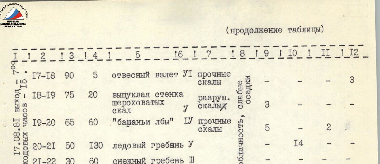
R12–R13: Chimney with a cork — 12 m, formed ice.
R13–R14: Short wall to a ridge-like slope, rocks limestone monolithic.
R14–R15: Exit to the top of the rock wall and further traverse to the right to the summit shoulder.
R15–R16: Up the chimney — difficult exit to the summit shoulder.
R16–R17: Along the ridge up to the vertical wall.
R17–R18: Along the vertical slab with a huge number of holds — difficult climbing, 5 m.
R18–R19: Further up the convex wall, rocks rough. Have to go on friction.
R19–R20: "Ram's foreheads" of the summit dome. Partially filled with formed ice.
R20–R21: To the left of the large summit cornice — exit to the south-eastern ridge along the ice ridge. In the upper part, the steepness decreases and the ice is covered with a layer of snow.
R21–R22: Along the snowy ridge to the right to the summit. Tour on the border of snow and rocks. Descent from the summit along the south-eastern ridge at first along the route of V. Kavunenko, then 5 rappels from the ridge to the glacier towards p. Kyz-Korgon.
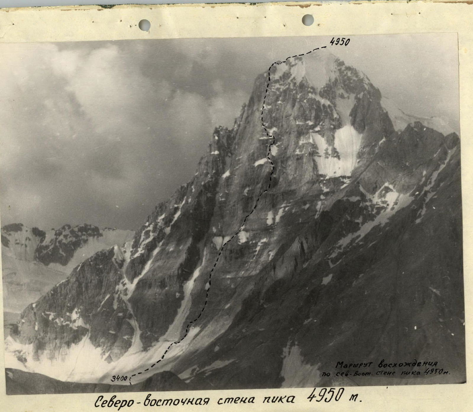
North-Eastern wall of peak 4950 m.