-
Climbing category: technical.
-
Climbing area: Southern spurs of the Alay mountain range, Kok-Su valley.
-
Peak Ossonaly, 4855 m, north face. (Peak height by altimeter 4807 m.)
-
Estimated difficulty category 5B.
-
Route characteristics:
height difference — 1005 m (by altimeter); length of sections with 5th cat. diff. — 425 m; 6th cat. diff. — 105 m; average steepness — 65°.
- Pitons driven for belaying:
rock — 171; ice — 15.
- Number of travel hours — 42.
- Number of overnight stays and their characteristics: three overnight stays on artificial platforms laid on rock ledges; two overnight stays — for resting lying down, and one — for resting half-reclining.
- Team leader:
Davyidov Petr Ivanovich — Candidate Master of Sports. Team members:
- Korkin Igor Vasilyevich — Master of Sports.
- Gasilov Evgeny Fedorovich — 1st sports category.
- Golenevskiy Sergey Vladimirovich — 1st sports category.
- Solovyov Boris Mikhailovich — 1st sports category.
- Team coach:
- Kolchin Alexander Alexandrovich — Master of Sports of International Class.
- Korkin Igor Vasilyevich — Master of Sports.
- Date of departure from the camp — August 12, 1977.
Return to the camp — August 18, 1977.
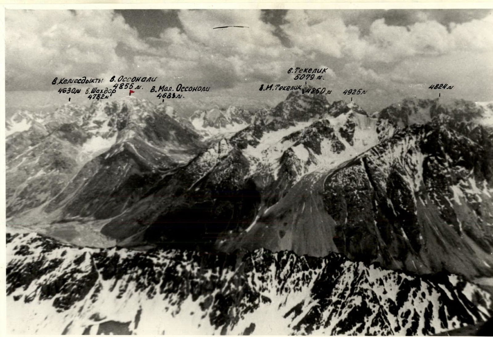
Panorama of the climbing area
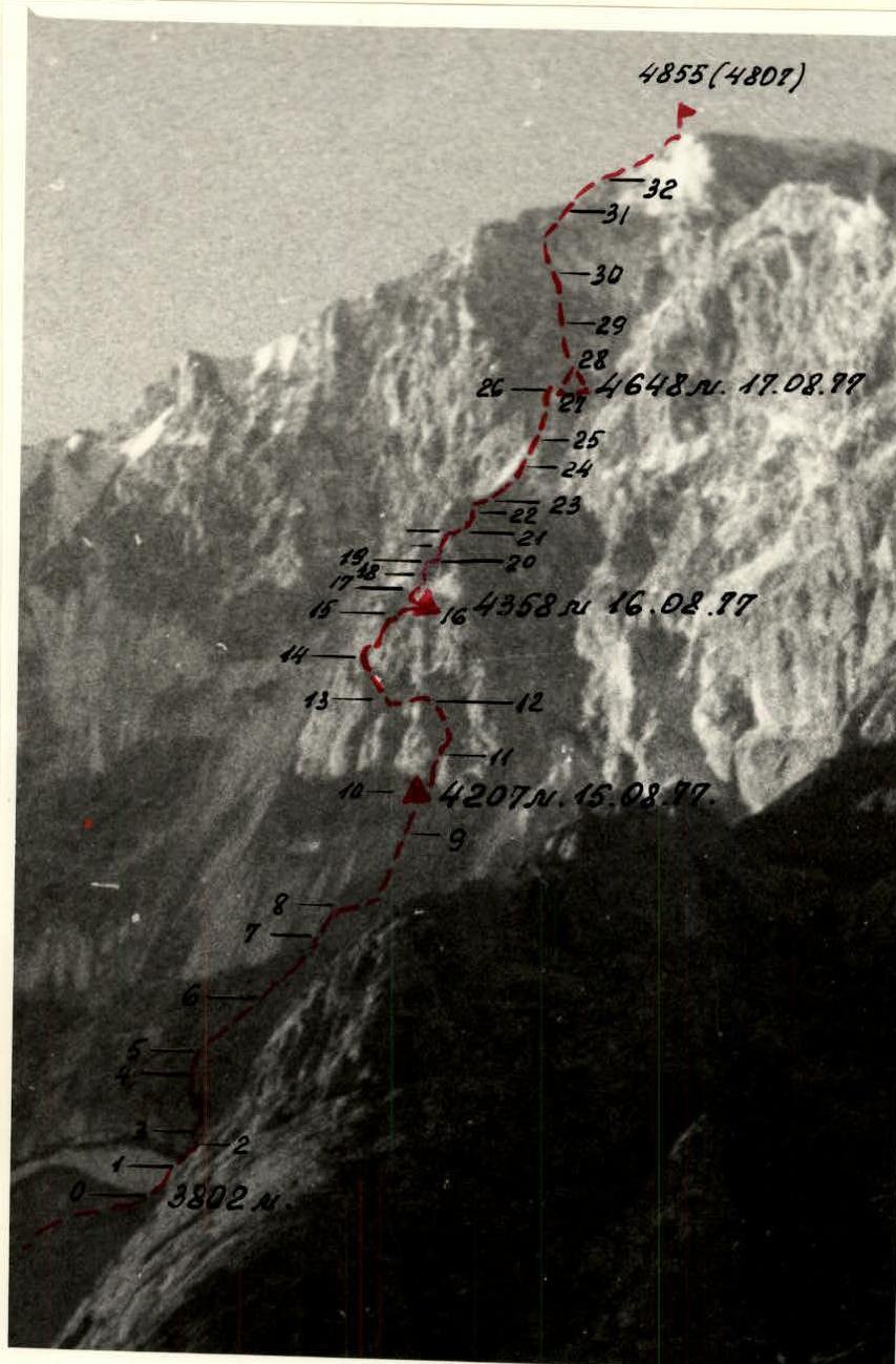
 Profile photo of peak 4855 (4807)
Characteristics of the Kok-Su area
The Kok-Su gorge is located in the southeastern part of the Pamir-Alay mountain system.
The upper part of the gorge, which is of interest for mountaineering, is bounded to the north by the Alay mountain range, and to the south by one of its spurs, which divides the valleys of the Kok-Su and Tekelik rivers. The Kok-Su River originates from the Abramov Glacier, one of the most powerful (11 km long) glaciers in the southeastern part of the Pamir-Alay. In the area of Lake Abramov, there is a stationary glaciological base of the Academy of Sciences of the Uzbek SSR, and the glacier itself has been an object of observation and research for several years.
Transverse spurs, which are watersheds of the 2nd and 3rd orders, form on the slopes bordering the Kok-Su valley a system of hanging valleys with glaciers of varying sizes, giving rise to the tributaries of the Kok-Su River.
In the hanging valleys located to the left of the Kok-Su River, the largest glaciers are:
- Glacier Kongur
- Glacier Alaudin
- Glacier Ulukol (Kara-Kazyk)
- Glacier Levinskiy.
Of the glaciers located to the right of the Kok-Su River, the largest is the Kemisdykty Glacier; fairly large glaciers are also found in the areas of the peaks:
- AydarBek
- Tekelik
- Ossonaly
- ShakhDar
- Jalgyz-Kunush.
There is slight glaciation in the areas of the tracts Begechi and Kaska-Su, located in the middle part of the Kok-Su gorge.
The lower part of the Abramov Glacier is located at an altitude of 3600 m. In the hanging lateral valleys, glaciers are typically located at altitudes of 3700–3900 m.
The area is dominated by peaks with heights ranging from 4700 to 5200 m; the highest point in the area has a height of 5205 m. There are a number of lower peaks that are of interest as objects for ascents.
The mountains in the Kok-Su gorge area have a monoclinal or folded structure and are composed of sedimentary rocks of the Precambrian era with rare inclusions of igneous rocks. Predominant are:
- marbleized limestones of varying hardness and structure;
- crystalline schists;
- much less common are hard pink marbles and hard gray granodiorites.
The slopes of the mountains with a predominantly southern (and especially southwestern) orientation are heavily destroyed, are relatively gentle, and, as a rule, do not have a snow-ice cover in their upper part throughout the summer season. Conversely, slopes oriented to the north and northeast:
- are less destroyed;
- have significant steepness.
On the northern slopes in the upper part, there prevail:
- rocks covered with flow ice;
- snow-ice boards, and "igristye" slopes.
The northern slopes have significant snow cover at the beginning of the summer season.
The peaks of the highest mountains in the area are crowned with ice domes with a characteristic ice structure. The ice on the summit domes is dense, brittle, and when steps are cut, it breaks off in large lenses.
The climate in the Kok-Su area, as everywhere in the southeastern Pamir-Alatau, is continental. In the upper part of the gorge, a considerable amount of precipitation falls in winter, while in the lower part, significantly less. The summer is hot, resulting in intense melting of the snow that fell in winter (especially in June), which causes sharp changes in the water level of the river depending on the time of day. A feature of the summer microclimate of the area is thunderstorms in the upper and middle parts of the valley, occurring with a frequency of about once a week. Moist air masses carried from the Alay valley by the prevailing southwesterly wind condense in the area of the upper and middle parts of the ridge bordering the Kok-Su valley from the south and form thunderstorm clouds.
However, thunderstorms are accompanied by:
- a slight amount of precipitation in the form of rain at the bottom;
- graupel or wet snow at the top, since most of the precipitation falls in the area of the Tekelik gorge.
At the same time:
- the onset of a thunderstorm is never unexpected;
- the weather deteriorates gradually;
- the deterioration of the weather lasts no more than one or two days.
The upper part of the gorge is characterized by constant strong winds having a direction corresponding to mountain-valley circulation. Strong, sometimes gale-force winds are also observed on the ridges and peaks of the mountains located in the upper and middle parts of the gorge.
The insignificant amount of summer precipitation is still sufficient to maintain a sparse but suitable for sheep grazing vegetation cover. The predominant vegetation is meadow and steppe. Among the shrubs in the middle part of the gorge, one can find:
- rose hips;
- barberry;
- currant.
Along the banks of the river and streams, juniper grows abundantly; birch, sea buckthorn, and sometimes even rowan are found.
Among animals, the most commonly seen is the marmot. Mountain goats, weasels, and hares also inhabit the Kok-Su area. According to shepherds, wolves occasionally visit the gorge.
Among birds, one can see:
- kokliks;
- udurs;
- large birds of prey.
Routes to the peaks in the Kok-Su area, both those that have been climbed and those that are potentially possible, are highly varied; however, rock-ice and rock routes predominate. Until 1977, no ascents were made in the Kok-Su gorge area, except for the ascent by a group of instructors to the peak "50th Anniversary of Uzbekistan" (4893 m) via a 5B category route. In the summer of 1977, groups of climbers from the Alay camp completed numerous ascents, both on the peaks of the Kok-Su area and on the peaks of neighboring regions, including:
- a number of interesting first ascents via complex routes that have not yet been classified.
General characteristics of peak 4855
Peak 4855 (local name Ossonaly) is located at the final node of one of the transverse spurs of the ridge running between the valleys of the Kok-Su and Tekelik rivers.
The lateral spurs extending from the node where peak 4855 is located, one to the west and the other to the east, bend northward as they descend and reach the Kok-Su valley, forming a hanging valley under the north face of the peak with a narrow exit blocked by the terminal moraine deposits of the glacier. From here, the DzhugurTash stream originates, which:
- first cascades down as waterfalls;
- then, filling up and cutting through the alluvial cone consisting of mudflow deposits;
- flows into the Kok-Su River.
Somewhat below the confluence of the stream, the Kok-Su River flows under a blockage for almost 100 m, formed by a catastrophic mudflow that once passed through the DzhugurTash stream bed.
The glacier under the north face of peak 4855 is calm, flat, and completely open at the end of the summer season, ending at the cirque throat with a steep, high (15–30 m) scarp, the appearance of which raises questions about the possible causes of the mudflow that formed the blockage across the Kok-Su River.
The slopes of the ridge bordering the glacier from the east are steep and icy. There is a small node with an elevation (4234 m) in this ridge.
The ridge bounding the glacier from the west sharply lowers at the level of the middle part of the glacier and, flattening out, becomes talus-covered. Peak 4855 is composed primarily of marbleized limestones heavily subject to erosion, resulting in the rocks of the north face being:
- smoothed;
- slab-like;
- with a large- or medium-block structure.
The north face of peak 4855 ends in snow-firn slopes, covered in some places by avalanche cones, and dissected in its upper steep part along the entire base of the face by a sharp, broken line of the bergschrund. Closer to the base of the snow-firn slopes, there is a band of steep, местами sheer, ice-covered shore ice. In the central part of the face, the band of shore ice, reaching its maximum width, borders on the destroyed rocks at the base of a steep, somewhat forward-projecting rock bastion located in the center of the face and occupying most of its height. The upper part of the face above the bastion is an ice-filled, funnel-shaped mulde with steep, icy walls and a narrow throat. From the throat, a not very pronounced ridge, formed by a group of rock islands, steep at their bases and dipping under the ice with their upper, gentler slopes, extends upward and somewhat to the left.
There are also the following relief features:
- A short, sharp rock-ice ridge extends from the top of the bastion and abuts at the level of the mulde throat against the sheer walls bordering the mulde from the east.
- On both sides of the bastion, there are steep ice gullies.
The part of the face to the left of the bastion consists of steep snow-ice boards with rock islands protruding in places. The steep, brittle rocks above the snow-ice boards serve as a source of constant rockfall. The sheer, with traces of fresh chipping, rocks of the right part of the face are also highly rockfall-prone, and only the central part of the face of peak 4855, where the bastion is located, is logical and safe for laying ascent routes.
Approaches to the route
From the base camp on Komdeba meadow along the left bank of the Kok-Su River to the blockage at DzhugurTash meadow. Transition:
- across the Kok-Su River over the blockage;
- ascent along the right bank of the DzhugurTash stream;
- into the cirque under the north face of peak 4855 on the left lateral moraine of the glacier.
Travel time:
- from the base camp on Komdeba meadow to the blockage — 3 h 30 min;
- ascent to the cirque — 3 h 30 min.
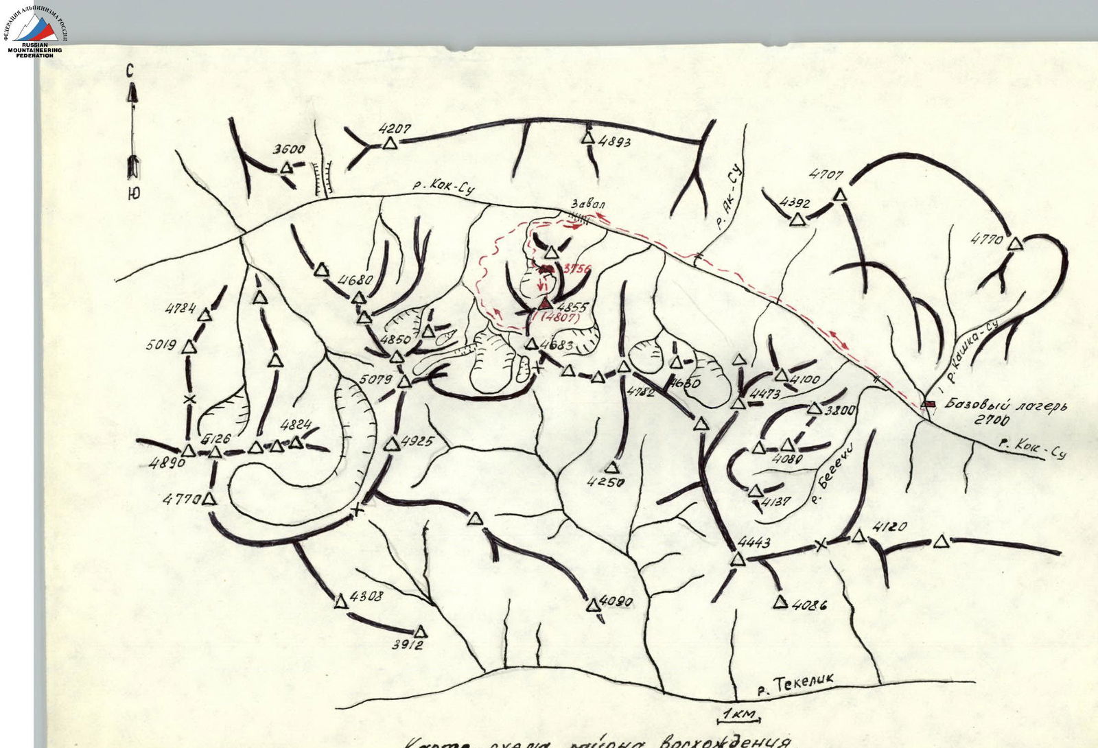
Schematic map of the ascent area.
Brief explanation of the table of main route characteristics
From the bivouac on the moraine along the left side of the avalanche cone under the right couloir of the face (R0–R1), through the bergschrund along the ice slope to the flat wall to the left of the ice couloir (R1–R2).
Up the rock wall 10 m (R2–R3), along inclined ledges left 50 m (R3–R4), and up the wet, sheer wall under the overhanging "forehead" (R4–R5) — exit to the steep "barani lby" under the walls of the bastion. In the morning, there is ice on the "lby".
Up the "barani lby" straight up (R5–R6) and (R6–R7) to the ice board descending from under the bastion. Along the ice board to the right and up — transition to the lower destroyed rocks of the bastion (R7–R8), and along them — under the right part of the steep walls of the bastion (R8–R9).
Up the steep rocks — to the gray slab under the right edge of the bastion terrace (R9–R10).
- Bivouac under the slab on a ledge — artificial platform, control point.
Along the gray slab 20 m and up the rock wall 10 m, passable with rope-pulling (R10–R11), — exit to the inclined terrace of the bastion. Along it to the left and up (R10–R12) to the U-shaped, steep, icy couloir. Traverse of the couloir (R12–R13) and ascent up to the end of the terrace (R13–R14) under the overhanging wall of the bastion. Possible bivouac.
Under the wall, traverse to the right and up the sheer inner corner (R14–R15) — exit to the destroyed rock ledges under the upper tower of the bastion (R15–R16). On the right part of the ledges on a rock ledge — artificial platform for bivouac.
From the rock ledges (R16–R17) to the steep slabs (R17–R18) under the rock wall (R18–R19). Up the wall to the steep ledge under the overhanging wall of the upper part of the bastion.
Traverse to the right (R19–R20) and up the inner corner of smoothed monolithic rocks with ice. In the inner corner — complex climbing using artificial holds and rope-pulling (R20–R21).
Along the inclined ledge, bypassing the outer corner of the bastion tower to the right (R21–R22), and exit to the steep rocks of the right lateral face of the bastion tower. Up them — to the ridge of the bastion (R22–R23).
Up the ridge of the bastion and the ice ridge (R23–R25) — ascent to the rocks in the lower part of the ice mulde. Up the steep, icy rocks (R25–R26) straight up to the narrow part of the ice couloir, bounded on the right by a large "cutting" tooth.
Traverse of the ice couloir above the tooth (R26–R27) and ascent up the narrow ice-rock couloir to the talus saddle behind the tooth (R27–R28). Traverse the couloir only when the snow mulde is low on water.
On the saddle — artificial platform for bivouac. From the bivouac, up the icy, smoothed rocks and rock islands on the ice of the mulde — ascent somewhat to the left and up to the ledges leading to the pre-summit ridge (R28–R31). Along the ledges to the left to the pre-summit ridge (R31–R32) and along the ridge to the right to the summit (R32–R33).
Description of the descent from the summit
From the summit along the western ridge to the fork where it divides into the SW and NW ridges. Down the SW ridge, bypassing some of the ridge rocks on the left along talus ledges, to the second, not very pronounced dip in the ridge. From the dip to the right begins a gray couloir with a narrow pink "osmyzhka" leading to a sandstone terrace. Down the couloir — descent in the direction of the ice board outcrops on the slope of peak 4685 m. Further — to the stream and down its bed to the cirque of the glacier under peak Tekelik. From it — to the blockage on the Kok-Su River.
Characteristics of the sections
| Date | Section | Steepness (°) | Length (m) | Relief characteristics | Cat. diff. | Condition | Weather conditions | Rock pitons (pcs) | Ice pitons (pcs) | Shlambur, ITO (pcs) | Method of passage | Time of exit and stop, travel hours, overnight stay conditions |
|---|---|---|---|---|---|---|---|---|---|---|---|---|
| 14.08 | R0–R1 | 40 | 150 | Avalanche cone | 2 | Snow, ice | Excellent | 1 | Simultaneously to the top of the cone | 05:00 exit from the bivouac on the moraine; 20 min | ||
| R1–R2 | 50 | 20 | Bergschrund and ice slope | 5 | Flow ice | 3 | Alternately | |||||
| R2–R3 | 80 | 10 | Slab | 5 | "Barani lby" | 3 | ||||||
| R3–R4 | 40 | 55 | Inclined ledge | 4 | 5 | |||||||
| R4–R5 | 90 | 10 | Rock wall | 6 | 2 | 2 rock pitons and undercut | 10 min | |||||
| R5–R6 | 60 | 50 | "Barani lby" | 5 | "Barani lby" with flow ice | 1 | Alternately | |||||
| 15.08 | R0–R6 | Passage of the section processed on 14.08 | Good | Along the perils | 2 h 50 min. Exit at 08:30. Stop for bivouac at 18:10. | |||||||
| R6–R7 | 45 | 50 | "Barani lby" | 4 | Wet "barani lby" with driven shlamburov | Cloudy | 7 | Alternately | 1 h 30 min. Travel hours: 9 h 40 min. | |||
| R7–R8 | 50 | 25 | Ice slope | 4 | Flow ice | 3 | ||||||
| R8–R9 | 60 | 80 | Slope | 4 | Destroyed rocks | 14 | ||||||
| R9–R10 | 75 | 60 | Rock wall (slabs, ledges) | 5 | Rocks covered with snow | Snowfall | 2 | |||||
| 16.08 | R10–R11 | 80 | 30 | Wall | 6 | Monolithic snow-covered rocks | Excellent | 7 | Perils, rope-pulling | 2 h 30 min. Exit at 08:00. Stop for bivouac at 18:20. | ||
| R11–R12 | 75 | 95 | Inclined terrace along the bastion | 5 | Icy snow-covered rocks | 15 | Alternately | |||||
| R12–R13 | 75 | 50 | Traverse of a steep "spal'nyy" couloir | 5 | Icy rocks, flow ice | 15 | Perils, carrying backpacks | |||||
| R13–R14 | 55 | 70 | Slope | 4 | Destroyed rocks | 11 | Alternately | |||||
| R14–R15 | 75 | 20 | Inner corner | 6 | Monolithic rocks | 4 | Perils | |||||
| R15–R16 | 45 | 30 | Rock ledge (traverse) | Destroyed rocks | 4 | Alternately | ||||||
| 17.08 | R16–R15 | Passage of the section 15-16 in the reverse direction | Excellent | Along the perils | 15 min | |||||||
| R16–R17 | 45 | 20 | Rock ledges | 4 | Destroyed rocks | 3 | Alternately | |||||
| R17–R18 | 50 | 10 | Rock slabs | 5 | Monolithic rocks, flow ice | 3 | ||||||
| R18–R19 | 80 | 10 | Rock wall | 5 | Icy rocks | 4 | ||||||
| 18.08 | R19–R20 | 80 | 15 | Rock wall (traverse) | 6 | Icy monolithic rocks | Excellent | 4 | Perils, pulling backpacks | |||
| R20–R21 | 85 | 30 | Inner corner | 6 | Monolithic rocks with flow ice | 4 | 2 rock pitons, 2 "zakladki", perils, rope-pulling | |||||
| R21–R22 | 60 | 30 | Inclined ledges bypassing the outer corner | 4 | Destroyed rocks | 3 | Alternately | |||||
| R22–R23 | 65 | 30 | Slope | 4 | 3 | |||||||
| R23–R24 | 20 | 70 | Sharp ridge | 5 | 3, "zastry" | Simultaneously | 20 min | |||||
| R24–R25 | 50 | 30 | Ice ridge | 5 | Hard ice | 1 | 3 | Alternately | ||||
| R25–R26 | 65 | 60 | Slope | 5 | Icy rocks | 9 | ||||||
| R26–R27 | 60 | 10 | Ice couloir (traverse) | 5 | Flow ice | 2 | 1 | |||||
| R27–R28 | 60 | 30 | Ice-rock couloir | 5 | Destroyed rocks and dirty ice | 3 | 1 | |||||
| 18.08 | R28–R29 | 70 | 30 | Slope | 5 | Icy snow-covered rocks | 4 | 1 | Alternately | |||
| R29–R30 | 65 | 60 | Slope | 4 | 8 | 1 | ||||||
| R30–R31 | 60 | 30 | Rock islands on the ice slope | 4 | Smoothed rocks and ice | 3 | 1 | |||||
| R31–R32 | 45 | 40 | Slope | 5 | Destroyed rocks | 3, "zastry" | 10 min | |||||
| R32–R33 | 20 | 180 | Ridge | 2 | Destroyed rocks | Outcrops | Simultaneously | 40 min |