Mramornaya Western, 4430 m, via the north-northeast face — first ascent
Group from the "Alai" alpine camp:
- CHOCHIA Pavel Antonovich, Candidate Master of Sports, instructor
- GORDEEV Ivan Mikhailovich, Candidate Master of Sports, instructor
- RODIKOV Anatoly Petrovich, 1st sports category
- SAKHAROV Vladimir Nikolaevich, Candidate Master of Sports
- FRIZYUK Nelli Zakharovna, Candidate Master of Sports, instructor
- KHASKIN Vladimir Yakovlevich, 1st sports category
Coach: KAVUNENKO Vladimir Dmitrievich, Master of Sports of the USSR
Kyrgyz SSR, 1979
Map of the ascent area
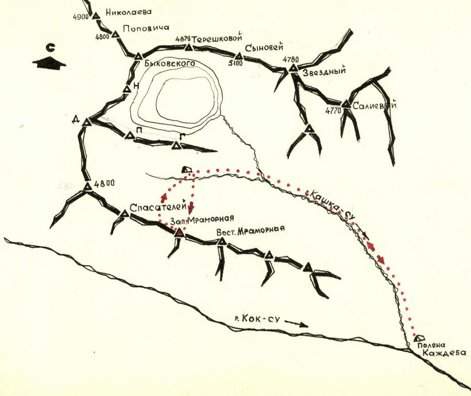
Brief description of the approach to the route
From the "Kashdeba" clearing, follow the trail along the Kashka-Su river up to the "Podkovy Kosmonavtov" cirque. The trail continues to the clearing under the slopes of peak "G", then ascend directly up the moraine slopes to the left of peak "G" to reach the glacier. This is a convenient spot for an overnight stay, opposite the north-northeast face of Mramornaya Western. The journey from the "Kashdeba" clearing takes 4-5 hours.
From the overnight stay:
- Cross the glacier
- Approach the wall of Mramornaya Western
Time from the overnight stay — 15-20 minutes.
Route description
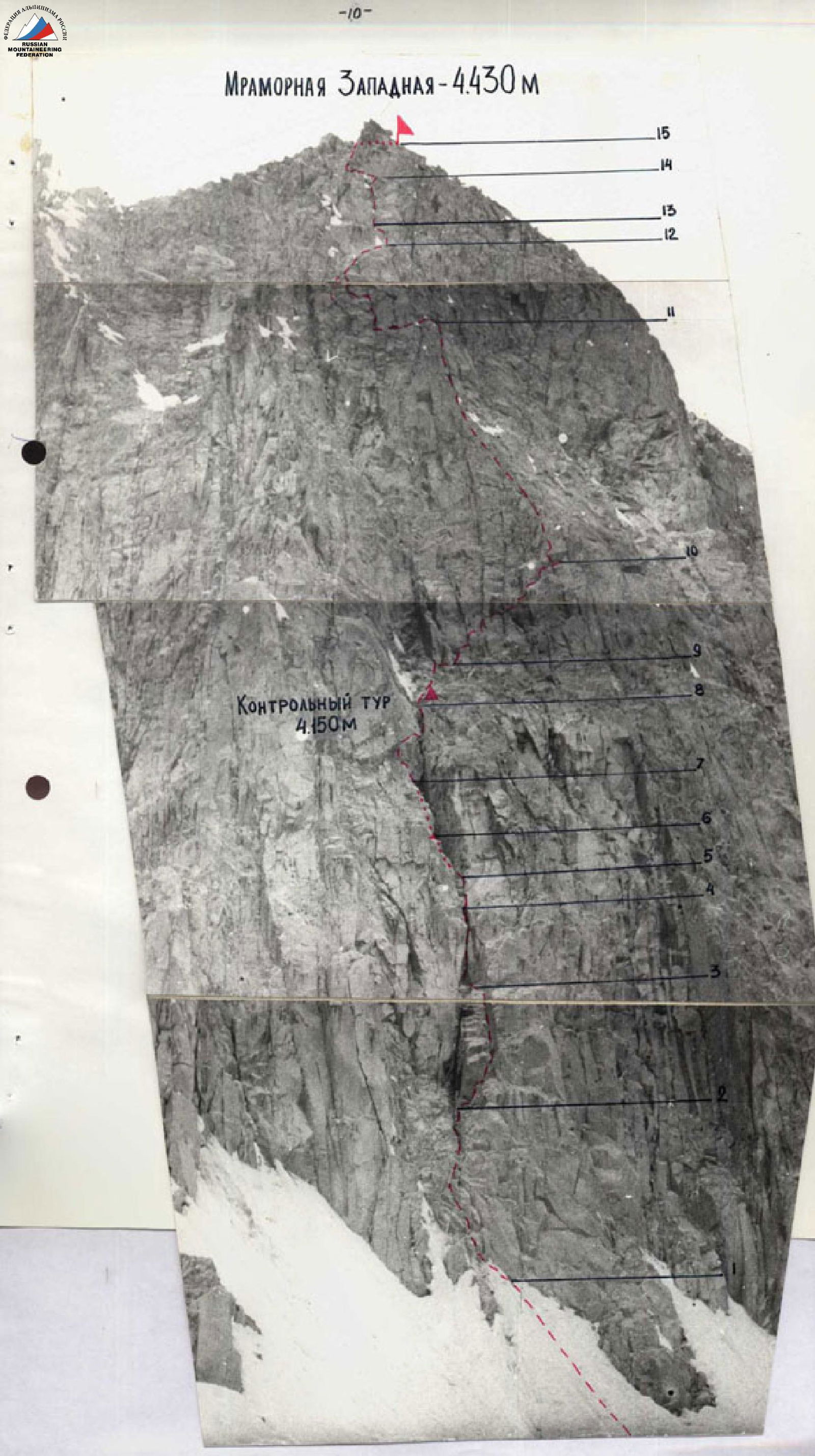
Departed from the overnight stay at 5:00. Reached the start of the route via the glacier (15-20 minutes). Ascended a snow-ice slope at 45° (80 m) to reach large-block, moderately difficult, broken rocks (50 m) in the direction of a vertical chimney. Entered the chimney via an inner corner on the right (difficult climbing – 20 m). Followed the wide, ice-filled chimney and a vertical slit to reach the first crux — an overhanging rock "plug" (complex climbing – 15 m, few handholds). Ascended onto the "plug" (very complex climbing, used a placed protection). From the "plug", exited left onto a rock ledge via the inner part of the chimney (15 m) and continued up the broken rocks of the chimney (10 m) (moderately difficult climbing). Approached the second crux — a vertical slit, via the left side of the chimney (15 m) (difficult climbing, few handholds). Exited the chimney via the vertical slit (very complex climbing) and an inclined crack (10 m). Reached a large, inclined, scree-covered ledge at 12:35. Built a control cairn on the right side of the ledge. From the control cairn:
- ascended the ledge (20 m) and moved right towards a rock "finger";
- followed monolithic, smooth slabs (40 m) to approach the "finger".
This is a convenient and safe ledge, suitable for an overnight stay. From the ledge:
- moved left around a bend;
- then ascended a weakly defined buttress;
- followed the buttress (80 m) to its left side and onto ledges;
- traversed left across the ledges (10 m) and ascended smooth rocks (10 m, moderately difficult climbing) to reach slabs;
- ascended smooth slabs and ledges (60 m, friction climbing, flakes) to a wall;
- approached the third crux — a flake, via the wall (10 m) on the right;
- exited the flake left into an inner corner (complex climbing);
- ascended the inner corner (10 m) to a wide ledge;
- exited onto the ledge and then onto the left side of the ridge and a rock ledge;
- ascended (20 m) moderately difficult rocks from the ledge to simple, broken rocks that led to the summit ridge;
- ascended the broken rocks (30 m) to the ridge;
- followed the ridge (50 m) to the summit.
Time: 18:00.
Descended from the summit to the west via a simple, broken ridge onto a snow-ice slope with a gradient of 30-35°. Then descended to the glacier and back to the overnight stay. The descent took about 1 hour.
PROFILE SCHEME OF THE ASCENT ROUTE
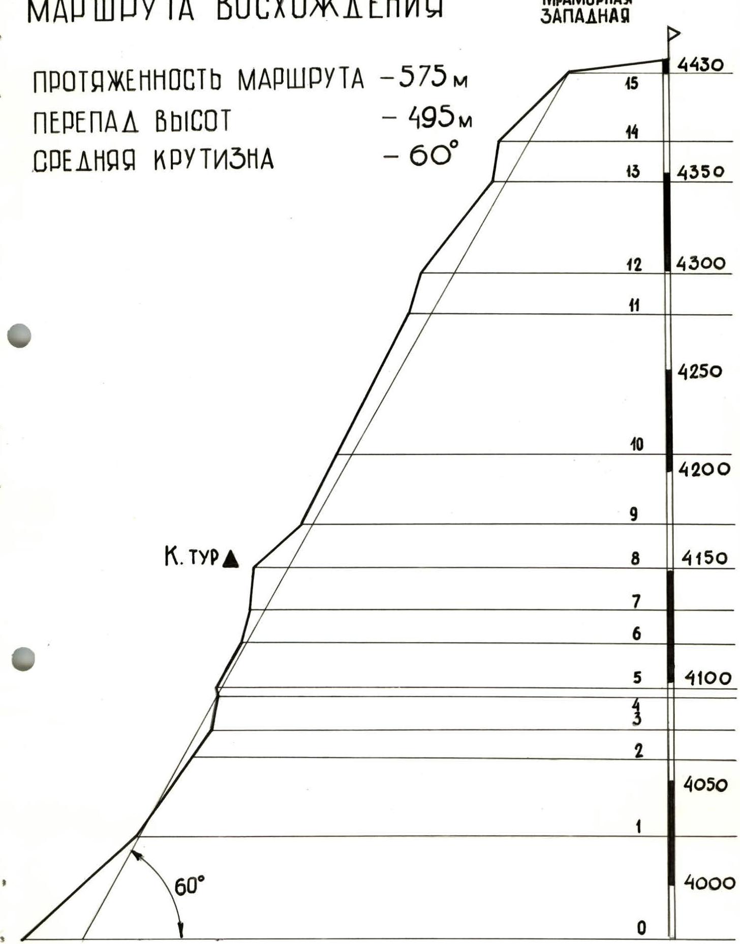
TABLE OF MAIN CHARACTERISTICS OF THE ASCENT ROUTE
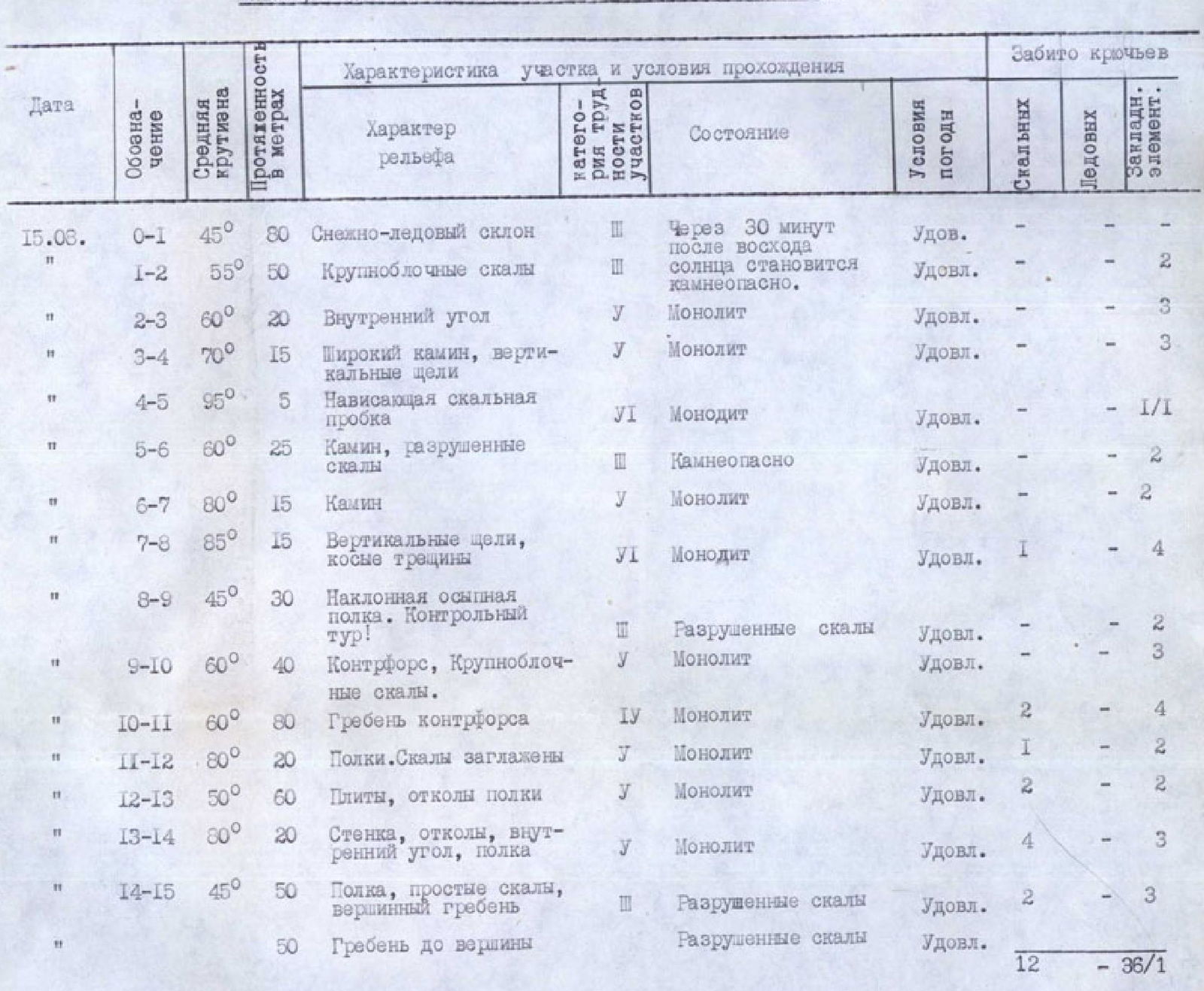
Brief explanation of the table
R0–R1. Snow-ice slope at 45°, 80 m long. The route should be started no later than 6:00 due to potential rockfall from the wall onto the start of the route.
R1–R2. Large-block, broken rocks. Moderately difficult climbing, 50 m.
R2–R3. Entered the chimney via an inner corner on the right. Difficult climbing, 20 m.
R3–R4. Wide chimney. Approached an overhanging rock "plug". Complex climbing, vertical slits, few handholds, 15 m. The chimney is filled with ice.
R4–R5. Ascended onto the "plug". Very complex climbing, used placed protection, 5 m. First crux.
R5–R6. Ascended the inner part of the chimney. Scree, simple broken rocks. Exited left onto a rock ledge (15 m). Then followed the chimney with moderately difficult climbing (10 m), broken rocks.
R6–R7. Followed the left side of the chimney (15 m). Difficult climbing, few handholds.
R7–R8. Then followed a vertical slit (5 m) and an inclined crack to the right (10 m). Exited the chimney. Very complex climbing. Second crux.
R8–R9. Ascended simple rocks (10 m) to a large, inclined, scree-covered ledge. Built a control cairn on the right. Ascended the ledge (20 m), simple climbing. Rocks are broken!
R9–R10. From the ledge, ascended right up monolithic, smooth slabs (40 m) towards a rock "finger". Under it is a convenient, safe ledge.
R10–R11. From the ledge, moved left around a bend, then ascended a weakly defined buttress. Followed it up (80 m) to its left side.
R11–R12. Traversed left across ledges (10 m) and then ascended smooth rocks (10 m). Moderately difficult climbing, few handholds.
R12–R13. Ascended smooth slabs, interspersed with ledges (60 m). Friction climbing, flakes.
R13–R14. Vertical wall (10 m). Passed it on the right via a flake. Traversed left into an inner corner. Complex climbing. Third crux. Then ascended the corner (10 m), moderately difficult climbing. Exited onto a wide ledge.
R14–R15. Exited onto the left side of the ridge onto a rock ledge. From it, ascended (20 m), moderately difficult climbing, and then (30 m) simple, broken rocks — exited onto the summit ridge. Followed the ridge (50 m) to the summit. Movement was simultaneous.
Descended from the summit to the west via a simple, broken ridge and then down a snow-ice slope to the glacier and the overnight stay. The entire route took 13 hours from overnight stay to overnight stay. Mramornaya Western — 4430 m