Passport
- Rock climbing category
- Pamir-Alay. Koksu gorge.
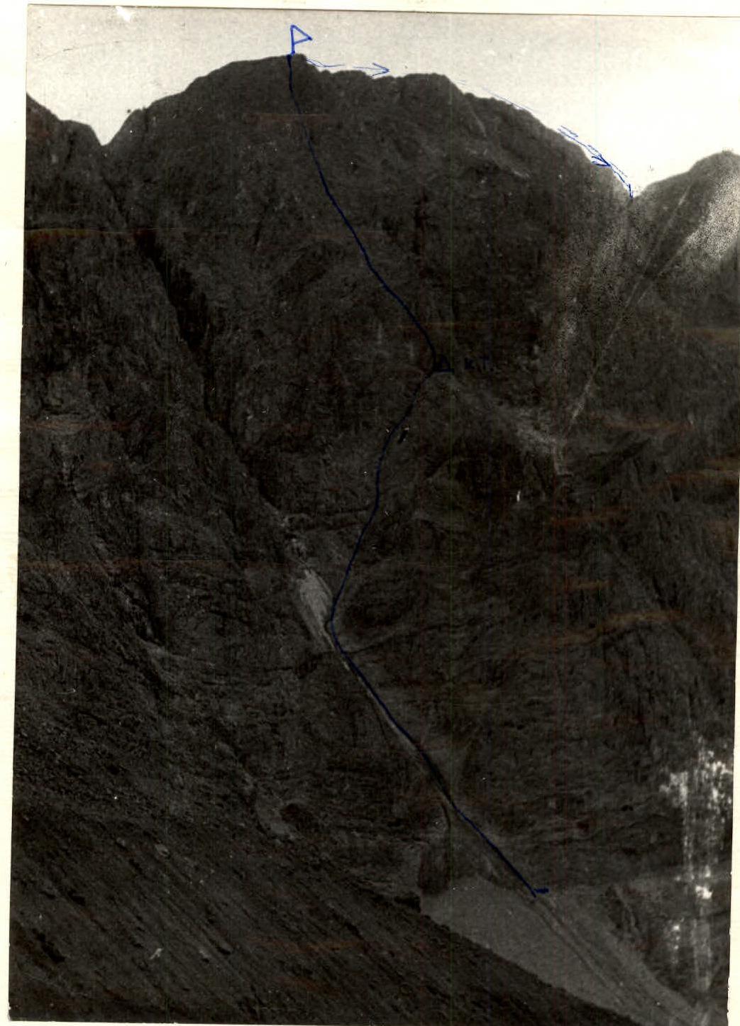
- Malenkiy Prints peak (4240 m) via the left part of the Eastern wall (route by Yu. Zadvoryev)
- Difficulty category — 5B (3rd ascent of the route)
- Height difference 850 m, length 1100 m.
Length of sections with 5–6 difficulty category — 650 m Average steepness of main sections 68° (3650–4200)
- Pitons driven:
| Rock | Bolt | Nuts | Ice |
|---|---|---|---|
| 55/0 | 0/0 | 32/0 | 0/0 |
- Climbing hours 14 and days 2
- Overnight stay: on a platform between the peak and subpeak on the descent.
- Serenkov Pavel Sergeyevich, Candidate Master of Sports
Ibrahimzade Dmitry Davudovich, Candidate Master of Sports.
- Coach: Tomchik Vitaly Silvestrovich.
- Approach to the route: August 9, 1982 Summit: August 9, 1982 Return: August 10, 1982

Ascent route to the peak 4240 m via the left part of the Eastern wall. Approximately 5B difficulty category.
Brief Description of the Ascent
The ascent to Malenkiy Prints peak was made by the team of Serenkov P.S. – Ibrahimzade D.D. as part of the Ukrainian Council Championship of the “Burevestnik” Sports Society in the rock climbing category and ranked 11th. This is the only peak (4240 m high) with a route of 5B difficulty category classified as a rock climbing ascent in the Koksu gorge area.
The first ascent was made in 1981 by a team from the Leningrad Military District and ranked 1st in the rock climbing category of the Armed Forces Alpine Championship.
Our team made the 3rd ascent of the route. We have been making joint ascents for 5 years.
We received exhaustive consultation on the route from the first ascenders and prepared accordingly.
We left the base camp located at Kozhdeba clearing on August 8 at 15:00. We reached the route in 3 hours and spent the night on the moraine. On August 9, we started the route at 5:30. We traversed the snow-ice couloir wearing crampons with alternating belay through an ice axe. At 6:45, we exited the couloir and moved right onto the rocks. Movement on the rocks was alternating only, on a double rope with organization of belay points on blocked pitons. We reached the control point at 11:30. We rested here and continued upwards.
We reached the summit at 17:30. After descending approximately 100 m from the summit, we spent the night on a ridge between the peak and subpeak. There was still enough daylight for the descent, but the overnight stay was planned according to the first ascenders' recommendation due to increased rockfall danger in the descent couloir in the second half of the day. For a comfortable overnight stay, we had a stove, a small tent, and other gear.
On August 10, we started descending at 6:00. We organized 1 rappel and 6 sport descents on a double rope with rope pull-through. By 8:00, we reached a gentle snow slope and descended to the glacier in the cirque of Ossonaly, Pravda Vostoka, and Malenkiy Prints peaks.
We descended to the geologists' base in the Koksu gorge at 9:30 via the glacier and then down a grassy slope. Here we met the observers.
We returned to the base camp at Kozhdeba clearing at 14:30. The tactical plan was fully executed. Special attention was paid to safety measures.
Radio communication was good, although the observers had to climb up to the cirque.
The route is logical, but the rocks are heavily deteriorated. There are many “live” stones on ledges and in chimneys. Climbing this route with a large team is not recommended.
To descend from the summit to the ridge, one should follow the left side of the ridge, and from there down a slope with up to 45° steepness to the right of the large couloir. The descent is safe, and spontaneous rockfall was not observed.
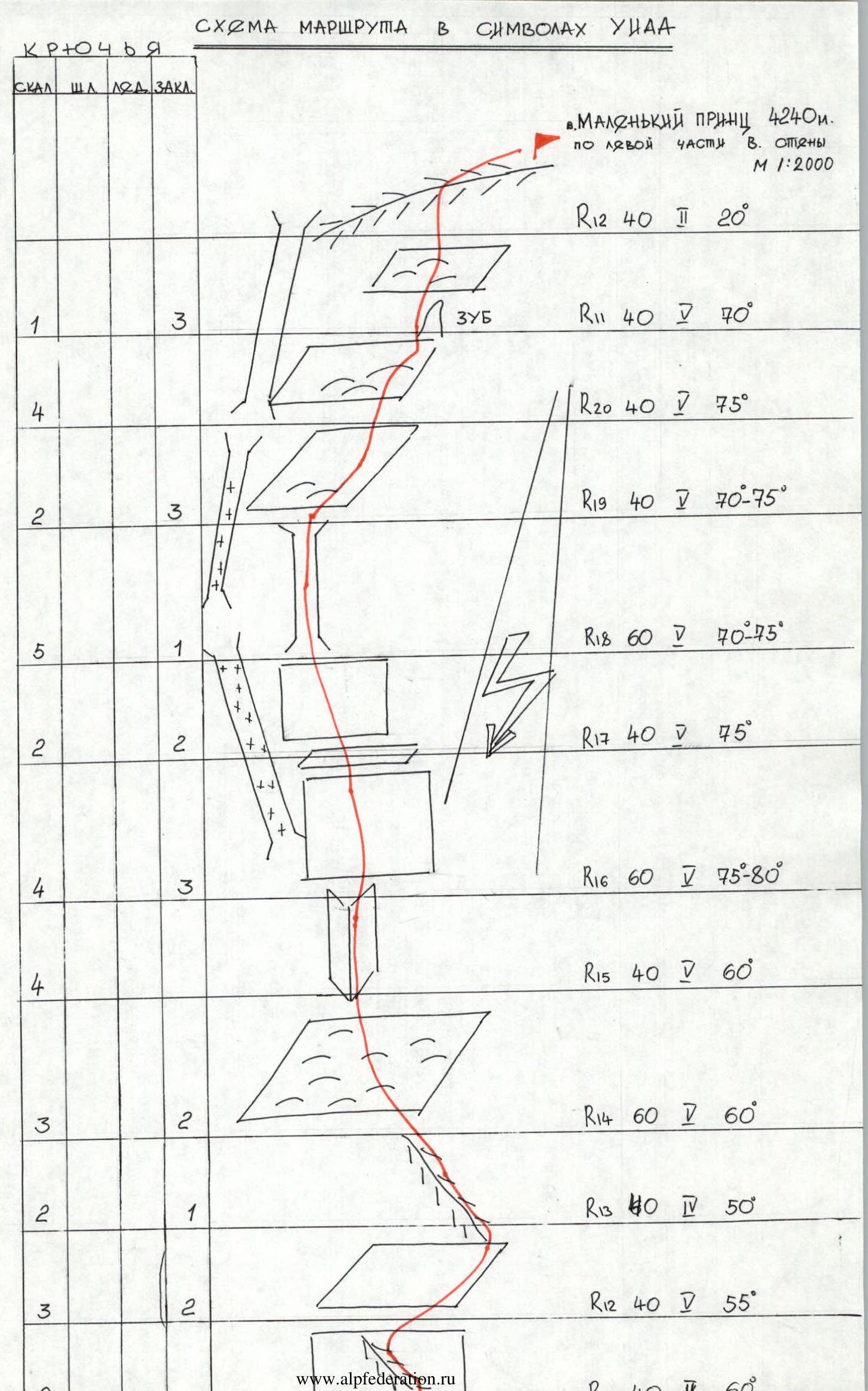
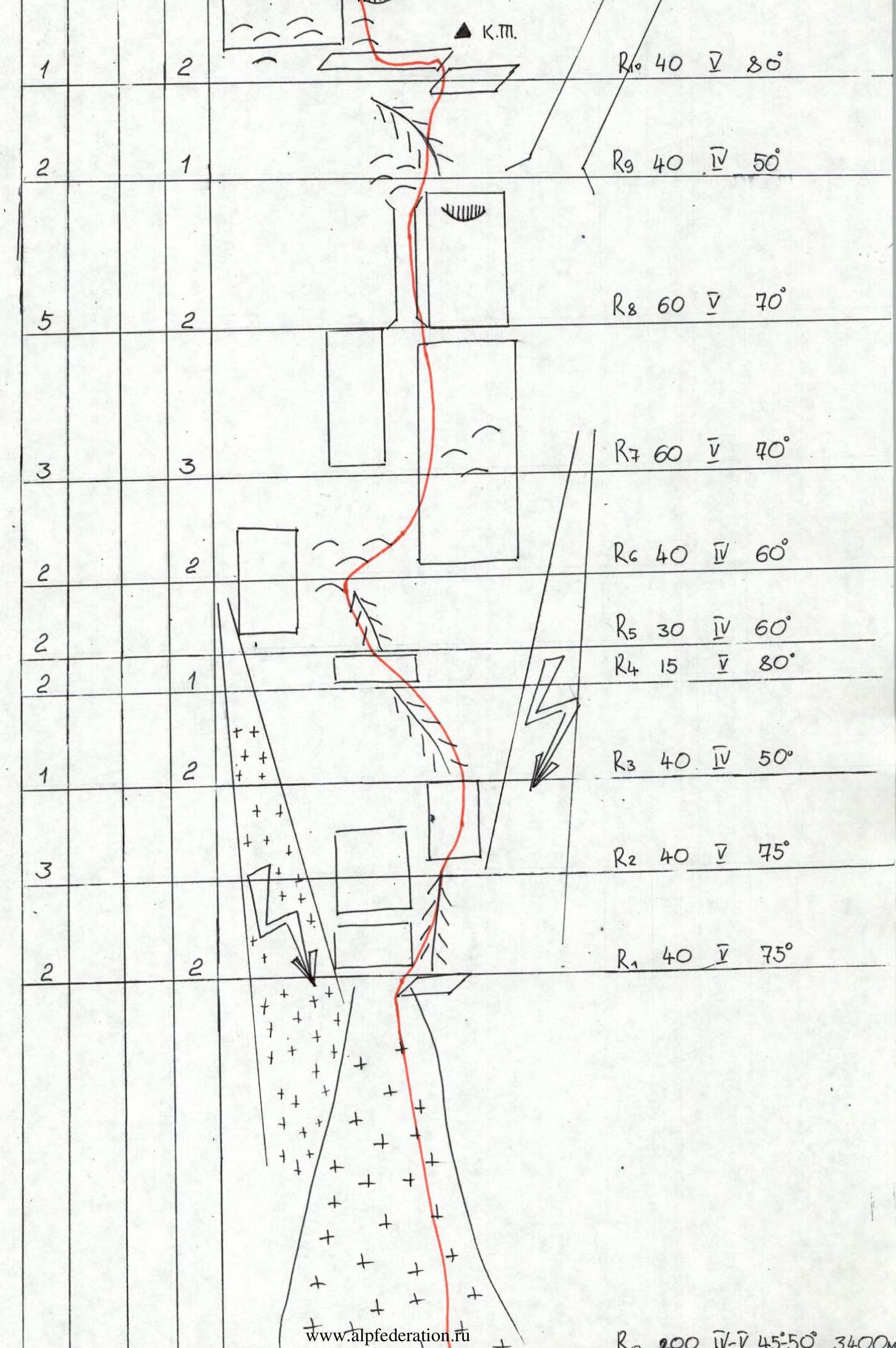
Route Diagram in UIAA Symbols
Malenkiy Prints peak, 4240 m. Via the left part of the Eastern wall. Scale 1:2000
Route Sections and Equipment
R0: 200 m, IV–V, 45–50°, 3400 m Pitons: rock: 1, nuts: 2 (for R10) Control Point (C.P.) R1: 40 m, IV, 75°. Pitons: rock: 2, nuts: 2 R2: 40 m, V, 75°. Pitons: rock: 3, nuts: 2 R3: 40 m, IV, 50°. Pitons: rock: 1, nuts: 2 R4: 15 m, V, 80°. Pitons: rock: 2, nuts: 1 R5: 30 m, IV, 60°. Pitons: rock: 2, nuts: 2 R6: 40 m, IV, 60°. Pitons: rock: 2, nuts: 2 R7: 60 m, V, 70°. Pitons: rock: 3, nuts: 3 R8: 60 m, V, 70°. Pitons: rock: 5, nuts: 2 R9: 40 m, IV, 50°. Pitons: rock: 2, nuts: 1 R10: 40 m, V, 80°. Pitons: rock: 1, nuts: 2 R11: 40 m, V, 70°. Pitons: rock: 4, nuts: 1 Top of the climb R12: 40 m, II, 20°. Pitons: rock: 1, nuts: 3 R13: 40 m, IV, 50°. Pitons: rock: 2, nuts: 1 R14: 60 m, IV, 60°. Pitons: rock: 3, nuts: 2 R15: 40 m, V, 60°. Pitons: rock: 4, nuts: 3 R16: 60 m, V, 75–80°. Pitons: rock: 4, nuts: 3 R17: 40 m, V, 75°. Pitons: rock: 2, nuts: 2 R18: 60 m, V, 70–75°. Pitons: rock: 5, nuts: 1 R19: 40 m, V, 70–75°. Pitons: rock: 2, nuts: 3 R20: 40 m, V, 75°. Pitons: rock: 2, nuts: 3 R12: 40 m, V, 55°. Pitons: rock: 3, nuts: 2