- Climbing type: rock climbing
- Climbing area: Pamir-Alay: Alay Ridge
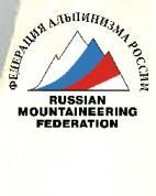
- Peak, its height, and ascent route: p. 4200 "Little Prince" via the edge of the West Wall
- Estimated difficulty category: 5A – 550 m – total
- Route characteristics: height difference – 450 m (wall section); average steepness – 65°; section lengths: total: 1070 m, including 2nd category of difficulty – 450 m, 3rd category of difficulty – 80 m, 4th category of difficulty – 256 m, 5th category of difficulty – 254 m, 6th category of difficulty – 30 m.
- Pitons driven: for belaying: chocks — 28 rock — 46 ice — 0 bolt — 0 total: 74 including for creating ITO (Intermediate Technical Object): chocks — 2 rock — 3 ice — 0 bolt — 0 total: 5
- Number of climbing hours: 12 + 4 = 16 hours
- Number of bivouacs and their characteristics: 1, lying down
- Full name of the team leader, participants, and their sports qualification:
Khankevich A.G. — 1st sports category Bashkirov V.L. — Master of Sports Nagoga M.L. — 1st sports category Kovanovsky V.L. — 1st sports category Yanchenkov V.Ya. — 1st sports category
- Team coach: Master of Sports of International Class Kavunenko V.D.
- Date: July 5, 1981 – July 6, 1981
Brief characteristics of the Kok-Su region and the object of ascent
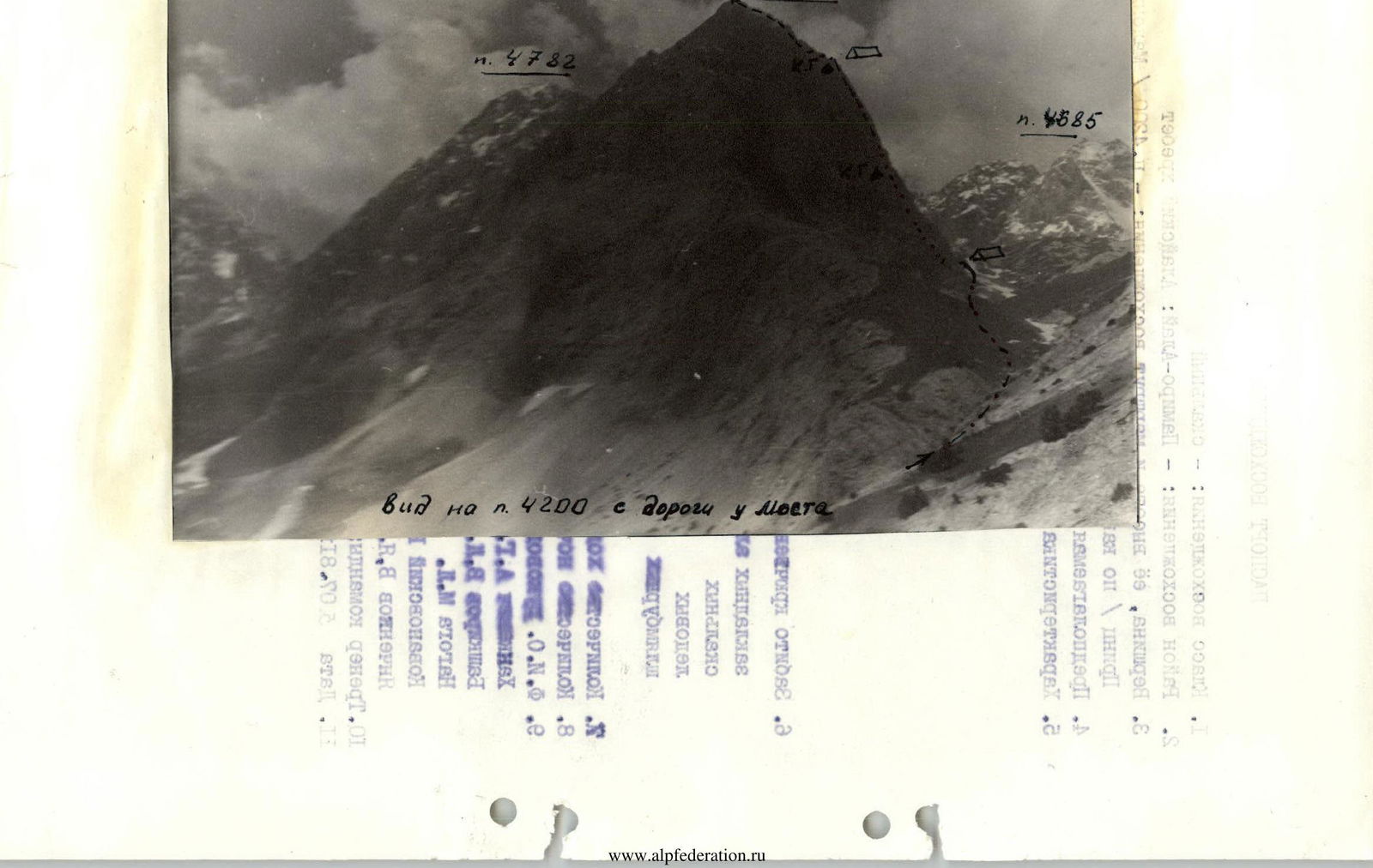
The Kok-Su gorge has been sufficiently explored by now. Since 1978, the sports team "ALAY" has been based at the Kozhdeba clearing. But along with the studied cirques and peaks in the gorge, there are still peaks and even cirques not yet explored by climbers.
The area around the peak Pravda Vostoka – Ossonaly is well-known. On peak Pravda Vostoka, well-known routes were established in 1976 and 1978. But the small cirque between Pravda Vostoka and Ossonaly was not explored by climbers until 1981, although when descending from peak 50 years of Uzbekistan (located on the other side of the Kok-Su gorge), the impressive West wall of the unnamed peak p. 4200 to the north of p. 4782 (Pravda Vostoka) is clearly visible.
The team from the Spartak Voluntary Sports Society (MGS DSO "SPARTAK") after a training ascent and reconnaissance to the cirque of South Ossonaly chose a route along the edge of the West wall of p. 4200, as a beautiful and logical route corresponding to the team's preparation before the Spartak Central Council championship.
Path to the cirque of the South Ossonaly glacier
From the Dzhuurtaash clearing, it takes 0.5 hours to walk up, crossing the bridge to the right (orographic) bank of the Kok-Su river. Then continue up the river to where the stream from the glacier in the cirque of South Ossonaly flows in. Cross the stream by a bridge and then ascend into the cirque of the glacier on the right (in the direction of travel) side of the stream. When reaching the glacier, stick to the left moraine. Overnight stays are on the right (orographic) moraine of the glacier under the West wall of p. 4200.
From the Dzhuurtaash clearing — 3 hours walking.
Map-scheme of the Fighting Day area
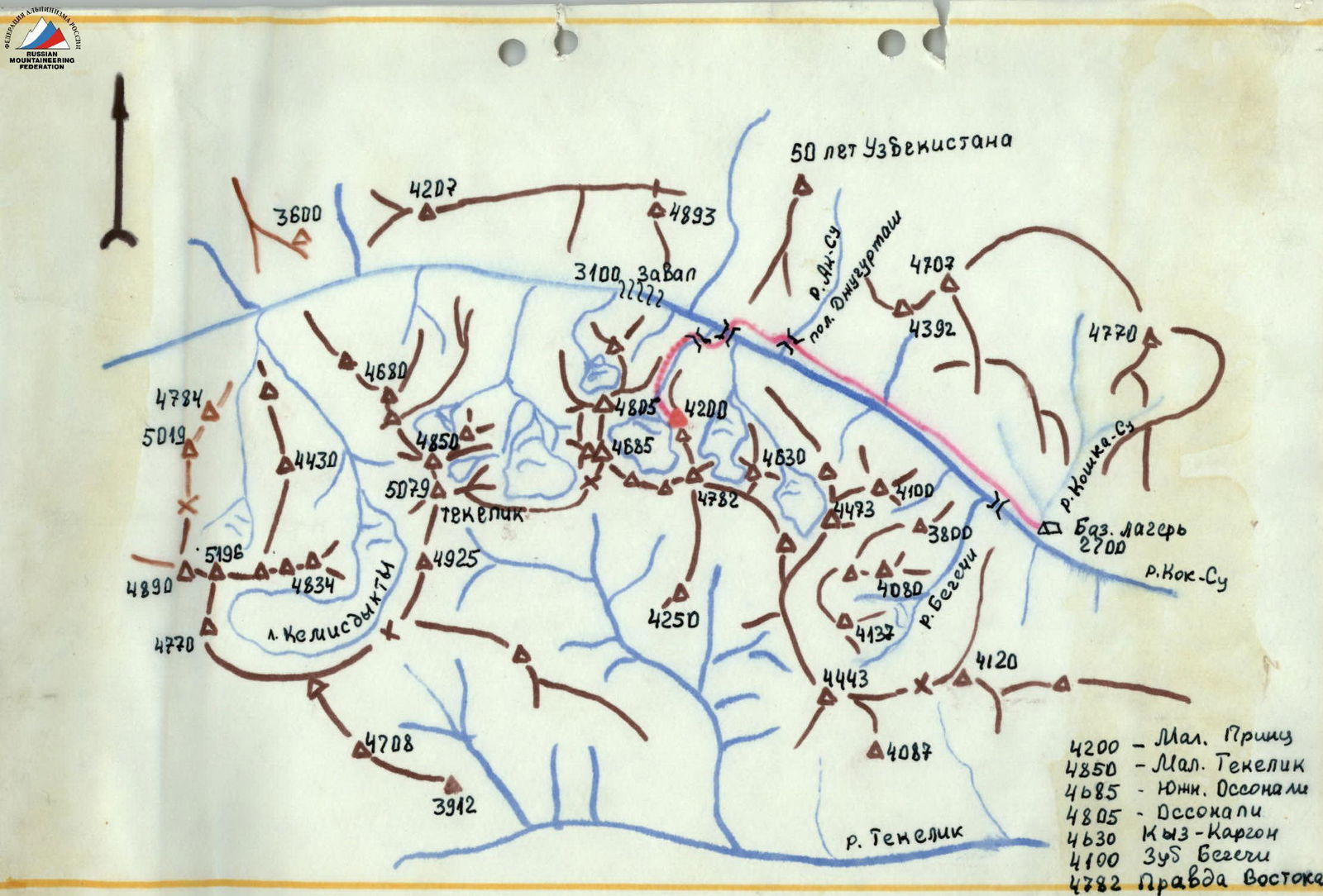
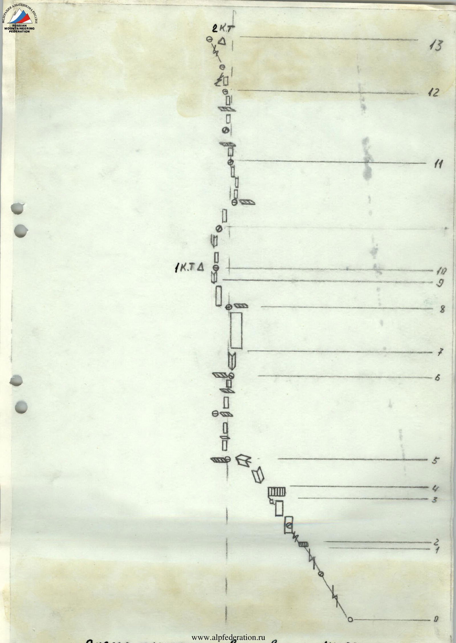
Table of main characteristics of the route along the edge of the West Wall to p. 4200
| Date | Designation | Average steepness | Length in m. | Terrain characteristics | Difficulty | Condition | Weather conditions | Rock | Chocks | Ice | Bolt |
|---|---|---|---|---|---|---|---|---|---|---|---|
| July 5, 1981 | R0–R1 | 50° | 46 | narrow crevice | 4 | monolith | good | 3 | 2 | - | - |
| R1–R2 | 75° | 4 | rock wall | 5 | monolith | good | 2 | 2 | - | - | |
| R2–R3 | 50° | 50 | narrow crevice, slabs | 4 | monolith | good | 3 | 2 | - | - | |
| R3–R4 | 85° | 10 | smoothed forehead | 6 | monolith | good | 4 | 2 | - | - | |
| R4–R5 | 60° | 20 | inner corner with stones | 4 | inner corner with stones | good | - | 3 | - | - | |
| R5–R6 | 55° | 80 | rock walls with ledges | 3 | ledges with lying stones | good | 1 | 4 | - | - | |
| R6–R7 | 65° | 10 | inner corner with ice | 5 | monolith | good | - | 2 | - | - | |
| R7–R8 | 70° | 70 | smoothed rocks | 5–6 | monolith | good | 7 | 2 | - | - | |
| R8–R9 | 65° | 50 | rocks | 5 | monolith | good | 4 | 2 | - | - | |
| R9–R10 | 70° | 10 | rock spall | 5 | monolith | good | - | 1 | - | - | |
| R10–R11 | 65° | 110 | black rocks, destroyed tile-like belt of black rocks | 5 | destroyed tile-like belt of black rocks | good | 10 | 5 | - | - | |
| R11–R12 | 60° | 80 | rocks | 4 | weathered, calcium crust | good | 6 | 2 | - | - | |
| July 6, 1981 | R12–R13 | 50° | 60 | crevice, slabs | 4 | weathered calcium crust on rocks | good | 4 | 1 | - | - |
| R13–R14 | - | 150 | ridge | 2 | monolith | good | - | - | - | - | |
| R14–R15 | 50° | 20 | rock wall | 5 | monolith | good | 2 | - | - | - | |
| R15–R16 | 40° | 300 | ridge | 2 | weathered calcium crust on rocks | good | - | - | - | 1 |
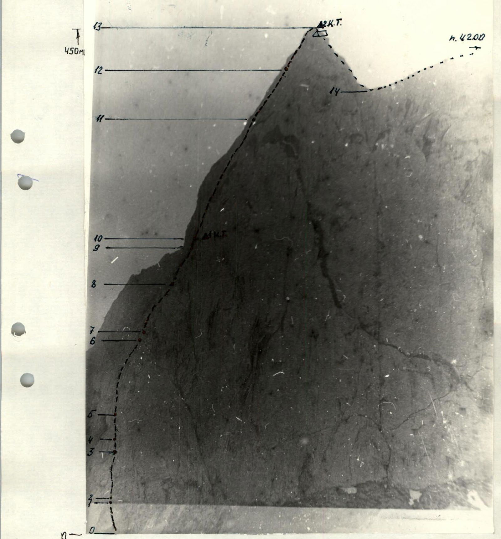
Description of the route to p. 4200 along the edge of the West Wall
The West wall of p. 4200 in the cirque of the glacier smoothly transitions into the Northwest wall, forming a pronounced edge. The route generally follows this edge.
The route begins through a nearly vertical crevice on the West wall, which leads out to the edge.
Up the crevice (R0–R1) under the wall (R1–R2) and then along the crevice through smooth slabs (R2–R3) under an overhanging smoothed forehead (R3–R4). The crevice crosses the forehead from right to left upwards. The forehead is overcome using ITO on ladders.
Then through an inner and outer corner — exit to a ledge (R4–R5). From the ledge, directly up the edge through destroyed rocks (R5–R6) with an exit to a ledge under the wall.
To the right upwards from the ledge, a spall filled with ice departs. At the top of the spall — exit in a spread between the wall and the spall (R6–R7).
Then directly up steep smoothed rocks like sheep's foreheads with an exit to an inclined ledge (R7–R8). From the ledge up the rocks (R8–R9) and the inner corner between the spall and the wall (R9–R10) — exit to a ledge behind the spall before the "Black Belt". On the ledge, a control cairn.
Then up through the destroyed black belt of rocks (R10–R11) to a ledge and then through smoothed rocks under the wall (R11–R12).
Bypass the wall to the left and then through a crevice (R12–R13) — exit to the ridge. On the ridge, a control cairn.
On the ridge:
- There are remnants of snowfields.
- There are good places for setting up tents.
- The group arranged an overnight stay here.
Along the ridge to a saddle (R13–R14). From the saddle, down the wall and then through a couloir, sticking to the right side in the direction of travel. 7 sport rappels lead to the glacier to the overnight stays.
Route features
The route is logical and safe in any weather. The rocks are mostly monolithic, which is a feature (since in the Kok-Su gorge, rocks are destroyed on most routes), except for the characteristic black belt crossing the West wall of p. 4200, and the upper part of the wall with a weathered calcium crust on the rocks. Cracks suitable for driving pitons and using chocks are found throughout the route.
On the wall section of the route, there is practically no water. Possible bivouac locations:
- before the inner corner with ice
- at the 1st control cairn.
The route is recommended for groups with good rock climbing training.
By right of the first ascenders and due to the beauty, complexity, logic, and "miniatureness" of the West wall of p. 4200, the group proposes to name the peak after the famous pilot and writer Antoine de Saint-Exupéry "Little Prince".
Team leader Khankevich A.G.