
- Climbing category — technical.
- Climbing area — Pamir, Pamir-Alay, Alayskiy Ridge, Kок-Су gorge.
- Peak, its height and climbing route — Kyz-Korgon, 4730 m via North-Eastern wall.
- Proposed category: 4A.
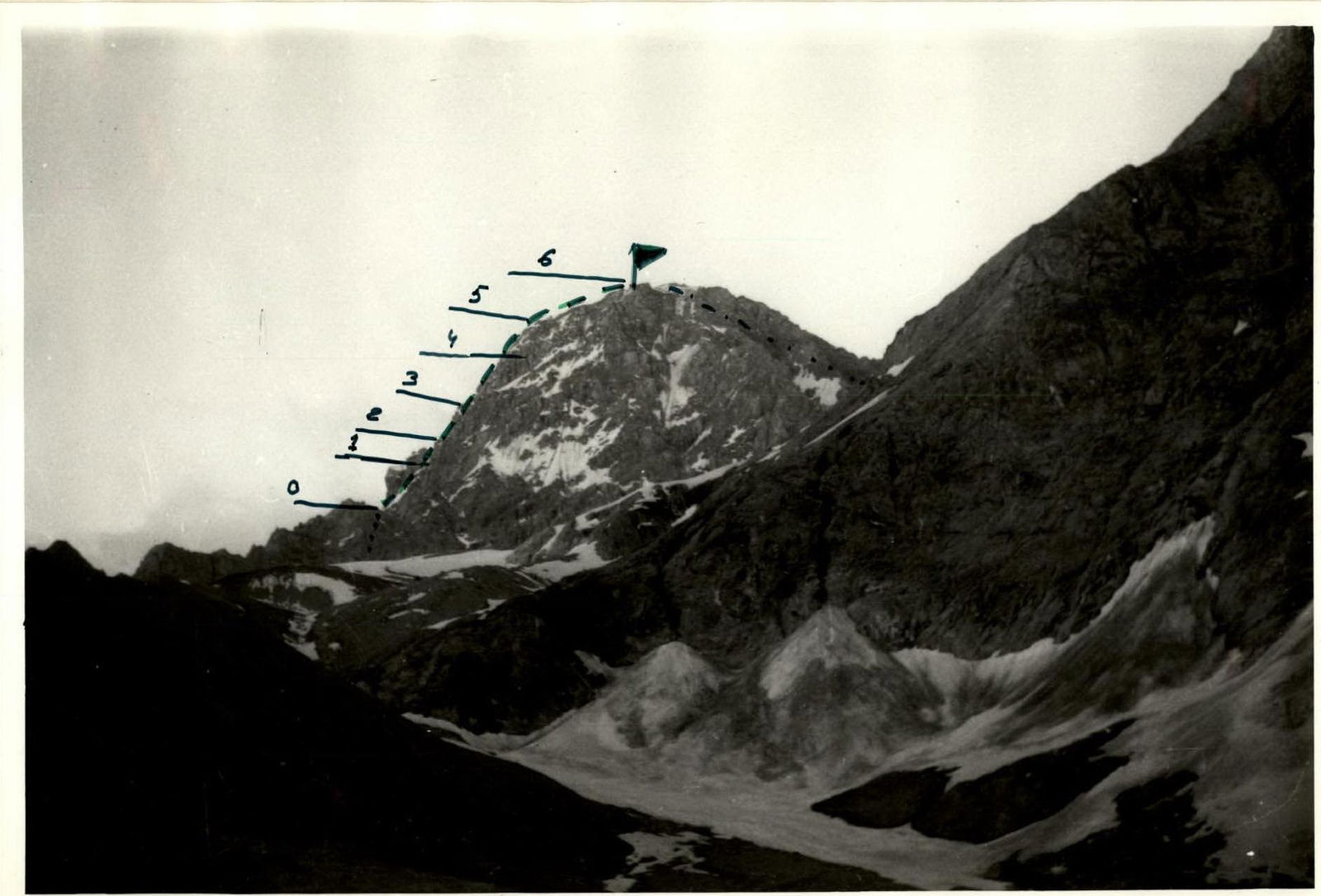
- Route characteristics: height difference — 300 m. average steepness — 40°. length of sections: I cat. diff. — none, II cat. diff. — 450 m, III cat. diff. — 500 m, IV cat. diff. — 600 m.
- Pitons hammered: | For belay | For creating R.P.E. | | :-------- | :----------------- | | rock 22 | 0 | | ice 4 | 0 | | bolt 0 | 0 | | chocks 6 | 0 |
- Total climbing hours — 12 hours.
- Number of nights and their characteristics — the route was completed in one climbing day.
- Surname, name, patronymic of participants, their sports qualification: Netsmekh Mikhail Vladimirovich, 1st sports category, Sadovnikov Vladimir Georgievich, Candidate for Master of Sports. (the ascent was made by a duo)
- Team coach — Kavunenko Vladimir Dmitrievich.
- Date of departure and return — July 2, 1978
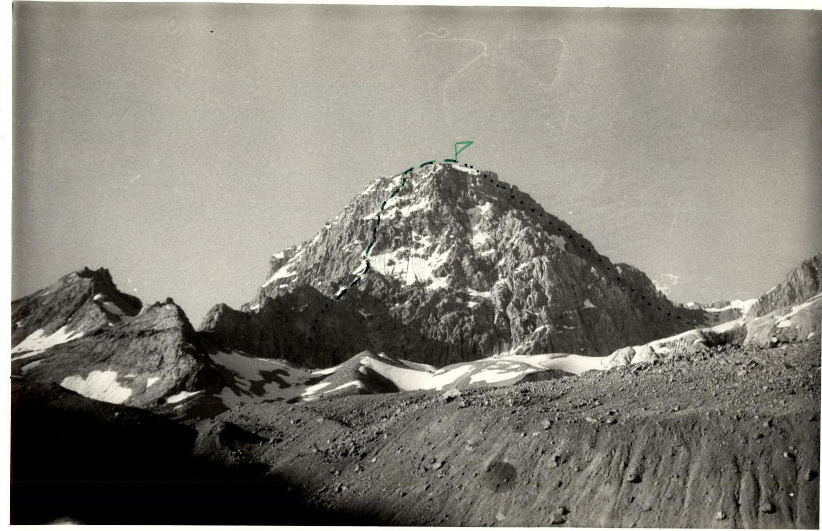
Description of the ascent route to the peak 4730 (Kyz-Korgon) via North-Eastern wall, 4A category (presumably)
From the base camp at Kozhdyba clearing, follow the trail along the left (orographically) bank of the Kок-Су river upstream to the bridge. The journey takes 3.5–4 hours. Cross the river via the bridge and, retracing your steps slightly (downstream), begin traversing the slopes to the right, without crossing the stream running along the bottom of the gorge and following horizontally going trails. Cross the stream over snow bridges or at a point where it disperses into several branches. On the right bank of the stream, there are extensive meadows suitable for setting up camp. The movement through the gorge takes 1.5–2 hours. The route begins from the saddle between the characteristic rocky "fence" (a long spur) and the North-Eastern wall. To reach the saddle, bypass the "fence" on the left, approach the junction of the spur with the slopes of Kyz-Korgon peak, and ascend via a gentle snowy couloir to the ridge. On the saddle — a cairn. Ascent from the saddle to the first snowy ridge crest involves traversing severely fragmented rocks for 300 m. Then, move left — upwards along a steep, convex snowy slope (with ice appearing in places) featuring rocky outcrops (150–200 m), and exit onto a severely fragmented rocky wall. Climb it, veering right, for 250–300 m, reaching the upper part of a characteristic long, steep snowy ledge. The rocky wall before the snowy ledge is overcome by complex climbing. The direction of movement is left-upwards towards an internal corner, and then upwards through it, utilizing minor holds. Then, ascend right-upwards along the snowy ledge and steeply upwards (45–50°) via fragmented rocky outcrops and snow (with ice underneath) towards a characteristic red triangular rock. Bypass the rock on the left. (Caution! Rockfall hazard!) It is necessary to utilize relief features for protection against possible falling rocks when the leader is moving in a rope team. Climb rocks of medium difficulty to reach the ridge of the North-Eastern shoulder. From the saddle — 6–8 hours. Features of the passage:
- Belay — pitons, through protrusions.
- Movement is simultaneous.
- In complex and hazardous sections — alternate belay.
Along the shoulder, move across snowy and talus slopes and along the ridge. Then, via несложным rocks towards the summit. Pay particular attention to safety when moving under the pre-summit cornice and when exiting onto the summit ridge. From exiting onto the shoulder to the summit — 1.5 hours. Then return to the wide red couloir and descend through it, across fine talus and snow, into the upper cirque. If there is ice in the middle part of the couloir, descend via the ledges on the right part of the couloir. Alternate belay is mandatory. Descent takes 1–1.5 hours. Then, descend along the glacier (Caution! Crevasses!) to the base camp. The ascent takes 12–14 hours. Movement in large groups is not recommended.
| Section # | Average steepness, ° | Length, m | Terrain characteristics | Difficulty | Condition | Rock pitons | Ice pitons | Bolt pitons |
|---|---|---|---|---|---|---|---|---|
| R0–R1 | 35–40 | 200 | edge | 3 | Fragmented, protrusions | 4 | – | – |
| R1–R2 | 35–45 | 150 | snowy ridge | 3 | Frozen | – | – | – |
| R2–R3 | 40–50 | 200 | walls, ledges for one person | 4 | Fragmented, highly icy | 10 | – | – |
| R3–R4 | 20–30 | 100 | snowy ledge | 2 | Soaked snow | – | – | – |
| R4–R5 | 45–50 | 250 | ridge with ice and snow | 4 | Fragmented, icy | 8 | 4 | – |
| R5–R6 | 10–15 | 300 | rocks, snowy ridge, talus | 3 | Soaked snow, cornices | – | – | – |
| R6–R7 | 30–40 | 1000 | descending snowy-talus couloir | 3 | Soaked snow | – | – | – |
Note to the table: Report date (approximately) — July 2, 1978