Description of the First Ascent to the Peak
of Jaan Kreuks (4634 m) via Route 4B cat. diff.
(Eastern Ridge) on July 20–21, 1977
- The approach from the base camp (helicopter pad at the mouth of the Kemisdykty River) to the Allaudin Glacier takes 3.5 hours. Crossing the glacier (open by the end of July) and ascending the right slope of the glacier's flank—the foot of Jaan Kreuks Peak—takes 1.5 hours. It is advisable to stop for the night here to start the route early in the morning. In the evening, rocks occasionally fall from the couloir to the right of the route.
- Start the route no later than 7:00 AM. Overcoming the R1–R2 section does not require special techniques, but traversing the ice slope towards the steep rocky buttress as you approach the bergschrund requires crampons (one pair per rope team) and ice screws. Exiting the bergschrund is challenging and requires step-cutting with piton belay. This is crucial as climbers in a team of two were carrying backpacks. Almost immediately after exiting the bergschrund, continue traversing the slope with a 60–70 % gradient, cutting steps in a closed stance with the left hand. The second climber in the team monitors the slope.
- Section R3–R4. The ascent onto the steep buttress is challenging. Caution is required due to steep, inclined slabs with unstable holds. Pitons are used—vertical, horizontal, and channel-type. There is a small platform for organizing a belay and pulling up backpacks. The direction is upwards and to the left.
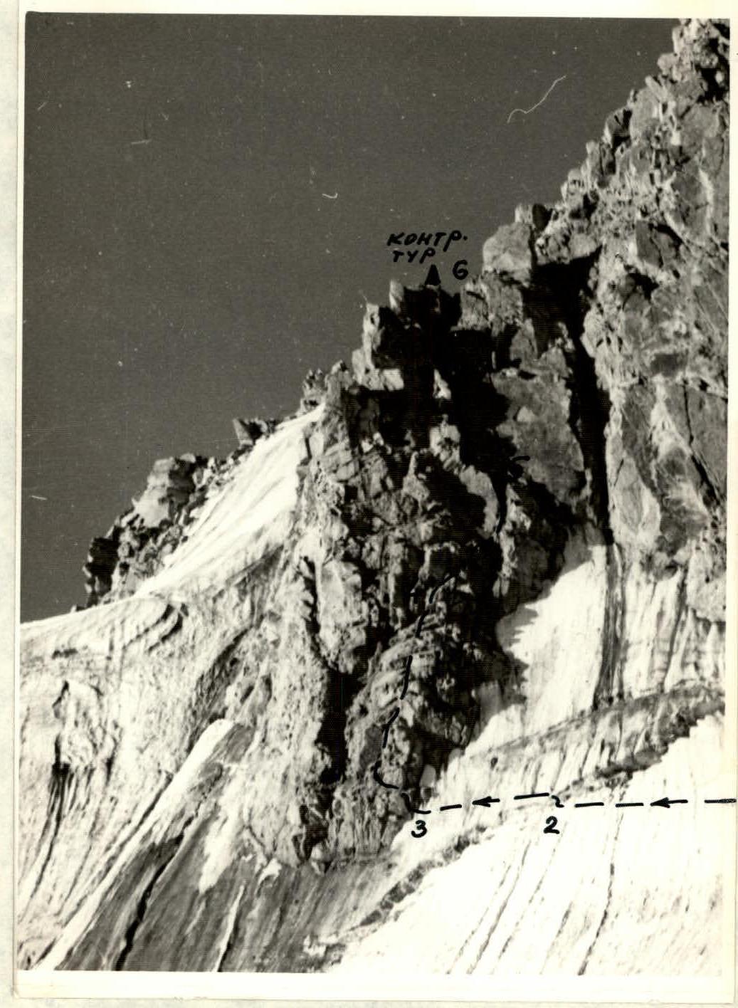
- Sections R4–R5 and R5–R6. Characterized by steep slabs forming two chimneys. The lower one goes right-up, then left-up—a ledge-angle after a plug at the top of the chimney. The plug is firmly in place. The lower chimney is overcome without a backpack, with piton belay. On the ledge, there is an intermediate piton belay. There is space for two climbers. Backpacks are pulled up on a rope. The second chimney goes 6–20 m up and to the right. It is steep (75–85°) and narrow. Pitons are mandatory. To the right, there are convenient holds on the slabs. At the exit from the chimney, again left-up on an inclined ledge, but when ascending subsequent participants (via fixed ropes or with top belay), caution is needed as the rope can dislodge rocks. Pulling up backpacks is difficult.
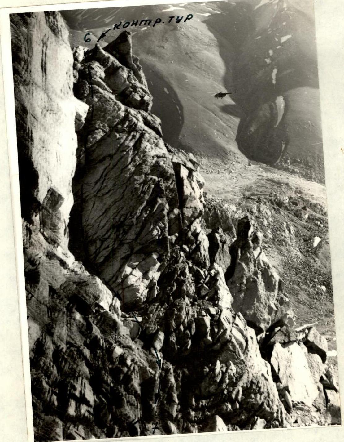
- The exit to the ridge is at the end of the R5–R6 section. To the right is a vertical pillar, and to the left is a small platform made of 2–3 stones. On one of them is a control cairn.
- Section R6–R7. Descend from the ridge along an inclined slab (overhung by a wall, forming a chimney) using a double rope to the red wall (on the right). The rope is anchored around one of the stones near the control cairn and is difficult to retrieve.
- At the red wall, there is a reliable piton belay. There is space for a channel-type piton. Then, move right-up along the wall along the edge of the couloir for 18–20 m (pitons), approach the wall—the threshold of the couloir—and traverse left with an ascent along "sheep's foreheads" protruding from the wall to a niche where a tent can be set up under the protection of the walls. Overnight stay requires fixed rope belay. Check the rope in the morning if it reached the bottom of the couloir (water is present in the evening but not in the morning). This is section R7–R9.
- Immediately up-right above the tent, and then up-left, there is an alternating system of slabs up to 8–10 m, walls, and "sheep's foreheads" with "live rocks" on them. After passing this section (with the wall on the right, where backpacks can be left) and traversing an inner corner, ascending left-up, you reach the end of section R9–R10, about 70 meters above the ice shoulder, which is higher than the main one visible from the Allaudin Glacier.
- Further progress on sections R10–R14 is characterized by a direction up-right towards the main ridge, under the overhanging white pillars-rocks. Belay is with pitons; the steepness of individual sections reaches 85° with a height difference of up to 15–20 m.
- The pillars-rocks are bypassed on the left as you move along, with a traverse of the couloir with a snow patch along its ridge part, then an ascent up the rocks to the sub-summit (section R14–R16).
- From the sub-summit, the path follows a relatively easy ridge, leading to a snow-ice saddle (with cornices on the right!), where a piton belay is used to descend onto the saddle (its lowest point), followed by an ascent to the summit along a rocky ridge.
- Descent follows the ascent route (without deviating to the right) until the end of section R9–R10. Then, a steep descent to the ice ridge (shoulder) located above the main one visible from the 4000 m camp. Further, there is a short traverse of the shoulder and a descent along a steep rocky buttress (100 m, piton belay) onto the main snow-ice shoulder, which steeply descends with an ice wall towards the Allaudin Glacier. Descent involves anchoring the rope around protrusions. From the main shoulder, it is more logical to descend in the direction opposite to the glacier, i.e., towards the Kok-Su River, along a steep, short rocky couloir ending in black rocks on the left and a waterfall. Another descent option is to rappel to the right into the main couloir and then exit right into a steep and deep couloir. Along the snow patch at the bottom of the couloir, with an ice axe belay, descend until reaching the wide, trough-shaped gully of the main couloir (before reaching the grassy slope ahead and to the left, and the kink—a turn in the main couloir). Up the gully to the left, with simultaneous belay, ascend to the ridge and from there, traversing the gentle snow-ice slope and moraine, return to the first night's bivouac.
The description was compiled by B. Naumov
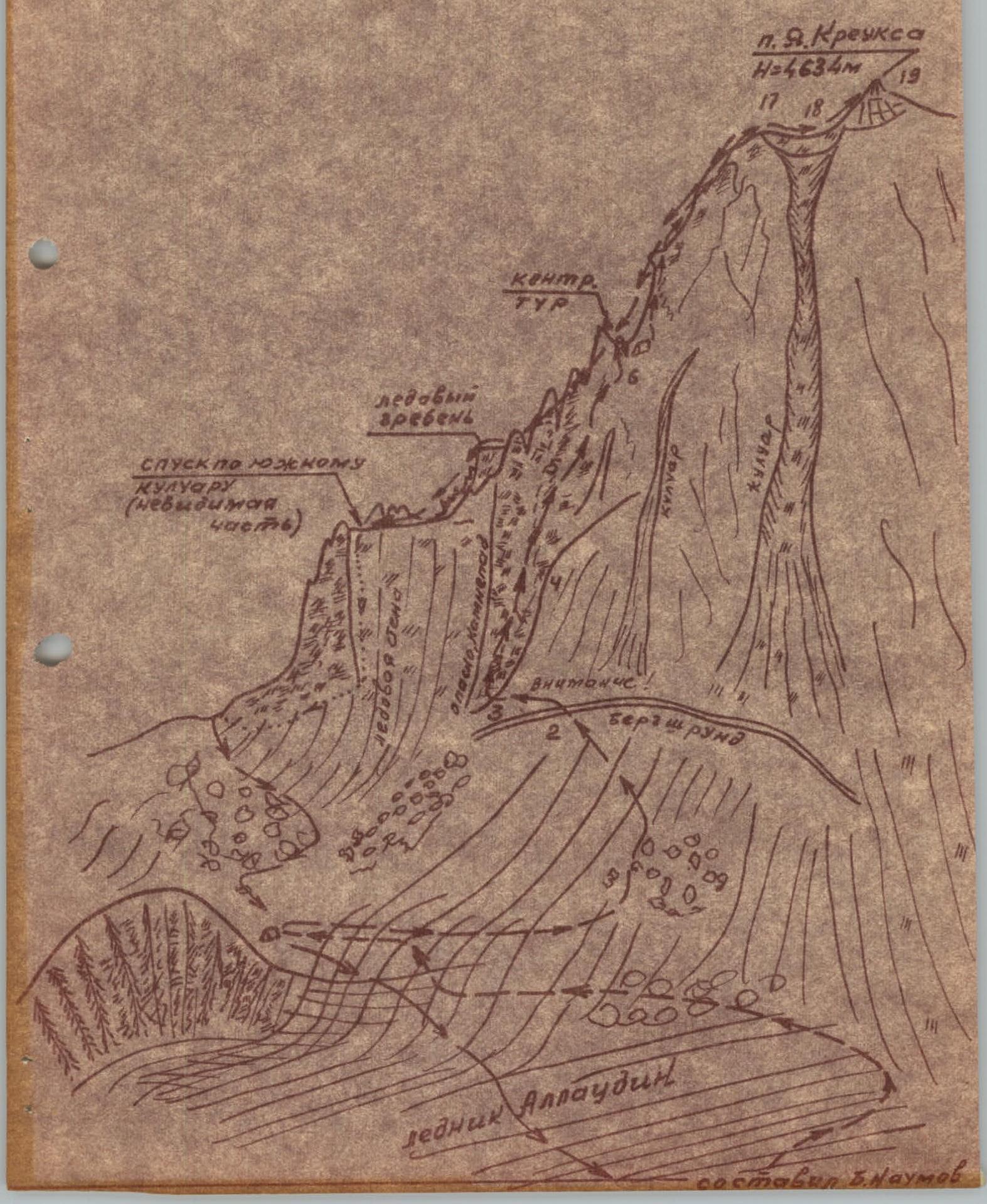 Profile scheme of the route along the eastern ridge.
ROUTE SECTION CHARACTERISTICS TABLE
| Date | Section Designation | Average Steepness, deg. | Length, m | Relief Characteristics | Difficulty Category | Condition | Weather Conditions | Number of Ice Pitons | Number of Rock Pitons | Number of Channel Pitons |
|---|---|---|---|---|---|---|---|---|---|---|
| July 20, 1977 | R0–R1 | 0–60 | 2500 | Open glacier, steep ascent at the end | 1 | Presence of closed crevasses | Sunny | – | – | – |
| R1–R2 | 35–40 | 650 | Snow, ice, frozen rocks | 3 | Stable | Sunny | 2 | – | – | |
| R2–R3 | 65 | 50 | Bergschrund, followed by an ice slope | 4 | Icy | Sunny | 3 | – | – | |
| R3–R4 | 60 | 80 | Buttress, unstable rocks | 4 | Unsatisfactory | Sunny | – | 8 | 1 | |
| R4–R5 | 75 | 40 | Chimney with a plug, ledge | 5 | Satisfactory | Sunny | – | 4 | 11 | |
| R5–R6 | 80 | 40 | Chimney with sharp slabs | 5 | Unstable | Sunny | – | 4 | 11 | |
| R6–R7 | 60 | 40 | Inclined slab—chimney into the couloir, to the red wall | 4 | Satisfactory | Windy | – | 2 | 1 | |
| R7–R8 | 50 | 20 | Left flank of the couloir | 4 | Unstable | Windy | – | 3 | – | |
| R8–R9 | 0–30 | 40 | Traverse of the couloir, ascent | 3 | Unstable | Satisfactory | – | 4 | – | |
| R9 | 0–20 | 1.2x1.5 | Niche—a recess for a tent | – | Satisfactory | Good | – | 4 | – | |
| R0–R9 | Departure at 7:00 AM, bivouac at 7:00 PM. Total climbing hours—10. Night conditions—satisfactory. | |||||||||
| July 21, 1977 | R9–R10 | 65–70 | 80 | Rocky buttress, alternating slabs, walls, small couloir | 4 | Unstable holds | Sunny | – | 6 | 11 |
| R10–R11 | 70 | 20 | Inner corner | 5 | Unstable | Sunny | – | 3 | – | |
| R11–R12 | 65 | 60 | Rocky ridge | 4 | Unstable | Sunny | – | 2 | – | |
| R12–R13 | 65 | 10 | Inclined wall | 5 | Satisfactory | Sunny | – | 4 | – | |
| R13–R14 | 60 | 40 | Rocky slope, snow, exit under overhanging rocks | 4 | Unstable | Sunny | – | 2 | – | |
| R14–R15 | 50 | 40 | Deviation left of overhanging rocks, couloir | 3 | Good | Sunny | – | – | – | |
| R15–R16 | 55 | 20 | Sub-summit | 4 | Unstable | Good | – | – | – | |
| R16–R17 | 20 | 20 | Ridge, rock, snow | 3 | Unstable | Good | – | – | – | |
| R17–R18 | 40 | 40 | Snow-ice slope, depression, cornices | 3 | Satisfactory | Sunny | 1 | 1 | – | |
| R18–R19 | 50 | 40 | Rocky ridge | 4 | Satisfactory | Sunny | – | – | – | |
| R9–R19 | Departure at 7:00 AM, on the summit at 11:30 AM. Total climbing hours—4. Descent from the summit and return to the 4000 m camp on the left flank of the Allaudin Glacier by 7:00 PM on July 21, 1977. |
Note: Descent from the summit follows the ascent route until section R9–R10. Then, a steep descent to the ice ridge below and to the right, from it—a piton-belayed descent along the boundary between ice and rocks (steep descent) onto the snow-ice shoulder visible from the camp. Further, a double-rope descent from the shoulder to the right-down into a deep couloir (bypassing a dry, short couloir) with snow, descending down the snow with an ice axe belay until turning left and before the kink—a rise left-up along a wide, lateral, stony gully of the couloir. Then, descend along the ice and moraine to the Allaudin Glacier.
 Exit to 44. Sections R2–R6.
 Section R6–R7 (exit to the Red Wall).