3. Summit, its height, ascent route
Peak 4784 m North-Eastern edge of p. Communa North.
4. Proposed difficulty category
5A cat. (first ascent)
5. Route characteristic, height difference
Combined 1500 m
Length of sections with 5–6 cat. difficulty: 465 m
Average steepness: 50°
6. Pitons driven: for belay, for creating artificial handholds:
Rock — II Ice — 16 Bolt — ∅
7. Number of walking hours — 17
8. Number of bivouacs and their characteristics —
9. Surname, name, patronymic of the leader, participants and their qualification:
Zaev E.F. — MS — leader Shchetikov V. — 1st sports category — participant Yanin V.A. — 2nd sports category — « — » Liplyavyy I.V. — 2nd sports category — « — » Chetkin A.N. — 2nd sports category — « — »
10. Team coach — Zaev E.F.
11. Date of departure and return
Departure — July 21 at 5:45
Return — July 21 at 23:00
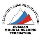
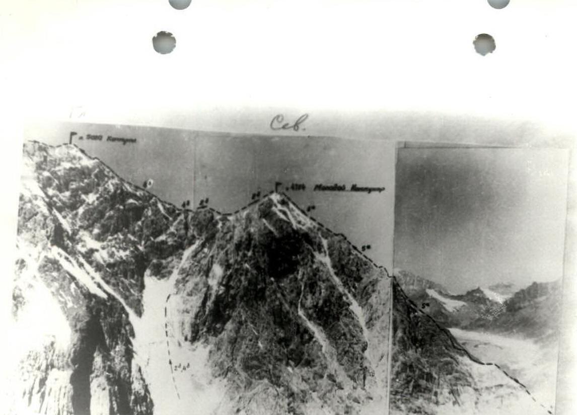
Photo 1. Panorama.
Photo 2. General view of the route.
| :--: | :--: | :--: | :--: | :--: | :--: | :--: | :--: | :--: | :--: | :--: |
|---|---|---|---|---|---|---|---|---|---|---|
| :--: | :--: | :--: | :--: | :--: | :--: | :--: | :--: | :--: | :--: | :--: |
| :--: | :--: | :--: | :--: | :--: |
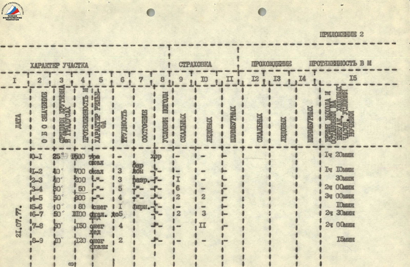
Brief explanation for the table
R0–R1. Section of grassy slope with rock outcrops. Rocks are bypassed via grass.
R1–R2. Section of rocks resembling "sheep's foreheads". Passed via stream beds and talus shelves. The I control point is located at (*) 2.
R2–R3. Ridge section consisting of fairly destroyed rocks. A small "gendarme" in the ridge is bypassed on the left via a crack under a rock finger. With belay through a rock piton. Belay via ledges.
R3–R4. The first "key" section, representing a ridge with gradually increasing steepness, turning into a rock tower. The tower is passed on the left via a crack or further left via the wall, with careful piton belay (channel-type pitons) in crampons. The 29th control point is located at (*) 4.
R4–R5. Ridge section consisting of destroyed rocks with ice and snow outcrops. Passed simultaneously and with alternate belay:
- via ledges or a piton,
- on ice — via ice pitons.
R5–R6. Section of a horizontal ridge, bordered on the right by a snow horizon. Passed simultaneously.
R6–R7. The second "key" spot is located on this section, representing an internal corner filled with ice.
Passed in crampons along the border of ice and rocks with belay via ice and rock pitons.
Upon exiting the corner, there are many loose rocks. Further — a rock ridge, passed with alternate belay via ledges.
R7–R8. The section consists of two snow-ice ridges, which are passed on the front teeth of crampons using an ice axe and an ice piton. Belay via ice pitons.
R8–R9. A simple section consisting of:
- a talus saddle,
- a snowy pre-summit rise,
- a rocky summit.
Passed simultaneously.
Descent is made to the left from the saddle between the peaks 4784.5 m and 5020 m via a snowy couloir. The bergschrund is passed on the left side of the couloir. Further down the open glacier and moraine to the Aydarbsk River. Along the river downstream to the stone bridge over the Kemisdikty River near the camp.
Descent: 2 hours 30 minutes.
As the first ascenders, the group proposes to name the peak "Molodoy kommunar" ("Young Communar"). The route corresponds to 5A cat. difficulty.