

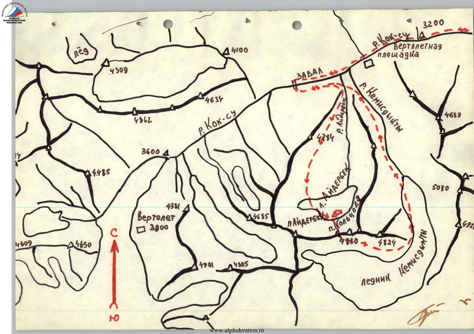
ASCENSION DOCUMENT Technical Class of the Ascent Pamir-Alay, Alay Ridge 3. P. Koltsova (4820) via the north face of the triangle 4. Category 5B difficulty 5. Route Characteristics: rocky height difference — 850 m, lengths of sections:
- Category 1 difficulty — none
- Category 2 difficulty — none
- Category 3 difficulty — 300 m
- Category 4 difficulty — 110 m
- Category 5 difficulty — 435 m
- Category 6 difficulty — 155 m
-
Pitons driven: rock 85 (for belay), 63 (for artificial climbing aids); ice 6; bolt 7.
-
Total climbing hours — 35 hours
-
Three bivouacs (2 seated, 1 lying)
-
Ascent participants: GRITSENKO V.N., Candidate for Master of Sports — leader. VEZNER A.E., Candidate for Master of Sports KLYUKVIN S.D., Candidate for Master of Sports LOPATNIKOV V.V., 1st sports category
-
Coaches — AGRANOVSKY G.L. NAUMOV A.F.
July 25–28, 1978
3200
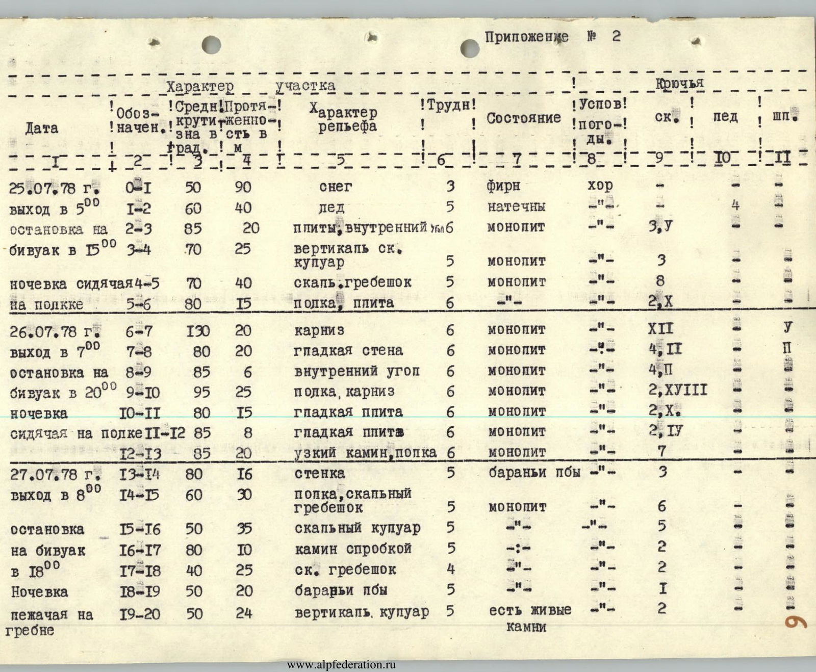
Appendix No. 2
| Date | Designation | Average steepness, ° | Length, m | Terrain characteristics | Difficulty category | Condition | Weather conditions | Rock pitons | Ice pitons | Bolt pitons |
|---|---|---|---|---|---|---|---|---|---|---|
| July 25, 1978 | R0–R1 | 50 | 90 | snow | 3 | névé | good | – | – | – |
| departure at 5:00 | R1–R2 | 60 | 40 | ice | 5 | flow | – | – | 4 | – |
| stop at | R2–R3 | 85 | 20 | slabs, internal corner | 6 | monolith | – | 3, 7 | – | – |
| bivouac at 15:00 | R3–R4 | 70 | 25 | vertical rock couloir | 5 | monolith | – | 3 | – | – |
| seated overnight | R4–R5 | 70 | 40 | rocky ridge | 5 | monolith | – | 8 | – | – |
| on a ledge | R5–R6 | 80 | 15 | ledge, slab | 6 | monolith | – | 2, 10 | – | – |
| July 26, 1978 | R6–R7 | 130 | 20 | overhang | 6 | monolith | – | 12 | – | 5 |
| departure at 7:00 | R7–R8 | 80 | 20 | smooth wall | 6 | monolith | – | 4 | – | 2 |
| stop at | R8–R9 | 85 | 6 | internal corner | 6 | monolith | – | 4, 2 | – | – |
| bivouac at 20:00 | R9–R10 | 95 | 25 | ledge, overhang | 6 | monolith | – | 2, 18 | – | – |
| overnight | R10–R11 | 80 | 15 | smooth slab | 6 | monolith | – | 2, 10 | – | – |
| seated on a ledge | R11–R12 | 85 | 8 | smooth slab | 6 | monolith | – | 2, 4 | – | – |
| – | R12–R13 | 85 | 20 | narrow chimney, ledge | 6 | monolith | – | 7 | – | – |
| July 27, 1978 | R13–R14 | 80 | 16 | wall | 5 | "ram's foreheads" | – | 3 | – | – |
| departure at 8:00 | R14–R15 | 60 | 30 | ledge, rocky ridge | 5 | monolith | – | 6 | – | – |
| stop at | R15–R16 | 50 | 35 | rocky couloir | 5 | monolith | – | 5 | – | – |
| bivouac | R16–R17 | 80 | 10 | chimney with a plug | 5 | monolith | – | 2 | – | – |
| at 18:00 | R17–R18 | 40 | 25 | rocky ridge | 4 | monolith | – | 2 | – | – |
| overnight | R18–R19 | 50 | 20 | "ram's foreheads" | 5 | monolith | – | 1 | – | – |
| lying on the ridge | R19–R20 | 50 | 24 | vertical, couloir | 5 | – | live rocks | 2 | – | – |
| – | R20–R21 | 40 | 20 | rocky ridge | 4 | – | "ram's foreheads" | 2 | – | – |
| – | R21–R22 | 45 | 15 | descent to a saddle | 4 | – | – | 1 | – | – |
| – | R22–R23 | 25 | 30 | crumbling ridge | 3 | – | "live rocks" | 1 | – | – |
| – | R23–R24 | 60 | 10 | ice wall | 5 | – | rocks covered in ice | – | 1 | – |
| – | R24–R25 | 50 | 30 | rocks | 5 | – | "live rocks" | 3 | – | – |
| – | R25–R26 | 50 | 45 | rocks | 5 | – | – | 4 | – | – |
| – | R26–R27 | 55 | 20 | loose couloir | 5 | – | – | 2 | – | – |
| – | R27–R28 | 65 | 45 | rocky couloir | 5 | – | – | 3 | – | – |
| – | R28–R29 | 45 | 50 | rocky ridge | 4 | – | blocks | 4 | – | – |
| – | R29–R30 | 60 | 10 | ice | 5 | flow | – | – | 1 | – |
| – | R30–R31 | 80 | 35 | slabs | 5 | – | rocks covered in ice | 7 | – | – |
| – | R31–R32 | 45 | 30 | rocks | 4 | simple rocks | – | 1 | – | – |
| July 28, 1978 | R32–R33 | 45 | 150 | rocky ridge | 4 | simple rocks | – | – | – | – |

The summit, descent to the Kemisdykty glacier, return to the camp. The northern slopes of Peak Koltsova are steep cliffs and walls. The right wall appears as a triangle, the apex of which is somewhat set back from the average slope steepness and reliably protects the wall of the triangle from rockfall. The average steepness of the wall is 85° with smooth slabs and overhanging cornices. The key section of the wall is a cornice in its middle part. It runs as a belt across the wall.
R0–R1. Represents firn snow up to the bergschrund with a steepness of 50° — 90 m (R0–R1). R1–R2. Through the bergschrund on flow ice towards the middle part of the wall (on the right part of the wall, a deep chimney goes up, to the left — an overhanging rocky cornice). Ice wall with a steepness of 60°, 40 m. 4 ice pitons driven. R2–R3. Towards a rocky corner with an overhang, which is passed from left to right 20 m — 85°. The upper part of the corner overhangs up to 95°. Slings used, 8 pitons driven. R3–R4. Then 25 m up a vertical rocky couloir 70°. 3 pitons driven. R4–R5. Along an indistinct rocky ridge 70° — 40 m under a smooth slab to its right part. 8 pitons driven. R5–R6. Up the slab 80° — 15 m (slings) up. 12 pitons driven. R6–R7. Key section of the route — the cornice. Steepness 120° — 20 m. Passed in a screw motion from left to right. 5 bolt pitons driven, 12 rock pitons. At the right corner of the upper part of the cornice, there is a small ledge for one person. R7–R8. Above the cornice, a 20-meter very smooth wall with a small number of cracks, which leads to an inclined ledge where all participants can gather. The section is very difficult, 2 bolt pitons driven, 4 rock pitons. R8–R9. Along a 6-meter internal corner with a steepness of 80°, the upper part — 3 m overhangs up to 95–100°. Slings used, 6 pitons driven. Exit to a ledge. R9–R10. Along an inclined ledge to the left corner 5 m, then up a crack under an overhanging cornice 85° — 25 m from left to right. The upper part overhangs — 100°. 20 pitons driven (slings). R10–R11. Exit to the right part of a smooth slab — 15 m, 80°, using a vertical crack. 12 pitons driven (ladders). Very difficult section. R11–R12. Then along a crack 8 m, which crosses the slab from left to right, almost abutting against the overhanging wall — to a ledge under a vertical crack (slings). 6 pitons driven. R12–R13. Up a vertical crack (can wedge hands and boot toes) 20 m to an inclined ledge. In the middle part of the crack, an overhang up to 95°. 7 pitons driven. R13–R14. From the ledge up — a wall type "ram's foreheads" 80° — 16 m with a small number of cracks for pitons. There are small holds. 3 pitons driven. R14–R15. Exit to a ledge, then along an indistinct rocky ridge 60° — 30 m. 6 pitons driven. R15–R16. To the right into a rocky couloir 50° — 35 m. 5 pitons driven. R16–R17. The couloir becomes steep, turning into a narrow chimney with a plug. 10 m, 80°. 2 pitons driven. R17–R18. The chimney exits onto a rocky ridge 40° — 25 m under an overhanging tower. 2 pitons driven. R18–R19. From the left side of the tower along "ram's foreheads" 50° — 20 m enter a rocky couloir leading to the tower. 1 piton driven. R19–R20. Along the rocky couloir 50° — 24 m — onto the tower ("live rocks"). 1 piton driven. R20–R21. Along the ridge type "ram's foreheads" 40° — 20 m exit to the apex of the triangle. 2 pitons driven. R21–R22. Having descended 15 m to a saddle (1 piton), there is a place for an artificial platform. R22–R23. Then along a crumbling ridge 30 m under an ice wall. R23–R24. Up the ice wall 60° — 10 m. 1 ice piton driven. R24–R25. Exit to rocks. Along rocks 50 m to the right window, which is visible on the ridge. Rocks covered in ice 50°. 3 pitons driven ("live rocks"). Then exit to the first ledge. R25–R26. Up rocks 50° — 45 m. 4 pitons driven. Towards a loose couloir, which turns into a rocky one. R26–R27. Along the loose couloir (2 pitons driven) 20 m. R27–R28. 45 m along a rocky couloir 65° to an indistinct rocky ridge. 3 pitons driven. R28–R29. Along the rocky ridge 45° — 50 m under an overhanging rocky tower. 4 pitons driven. R29–R30. Having passed between the "finger" and the tower on ice to the left of the tower (10 m of ice 60°) exit to slabs type "ram's foreheads". 1 ice piton driven. R30–R31. Along steep slabs covered in ice (very difficult) 80° — 35 m towards a window on the rocky ridge. 7 pitons driven. R31–R32. Along simple rocks 45° — 30 m exit to the pre-summit ridge. 1 piton driven. R32–R33. Along the ridge — to the left 150 m to the summit.
}