Climbing Route Description
to Begich Peak (4473 m) via Western Counterfort of the 10.3 ridge, category 3A (approx.).
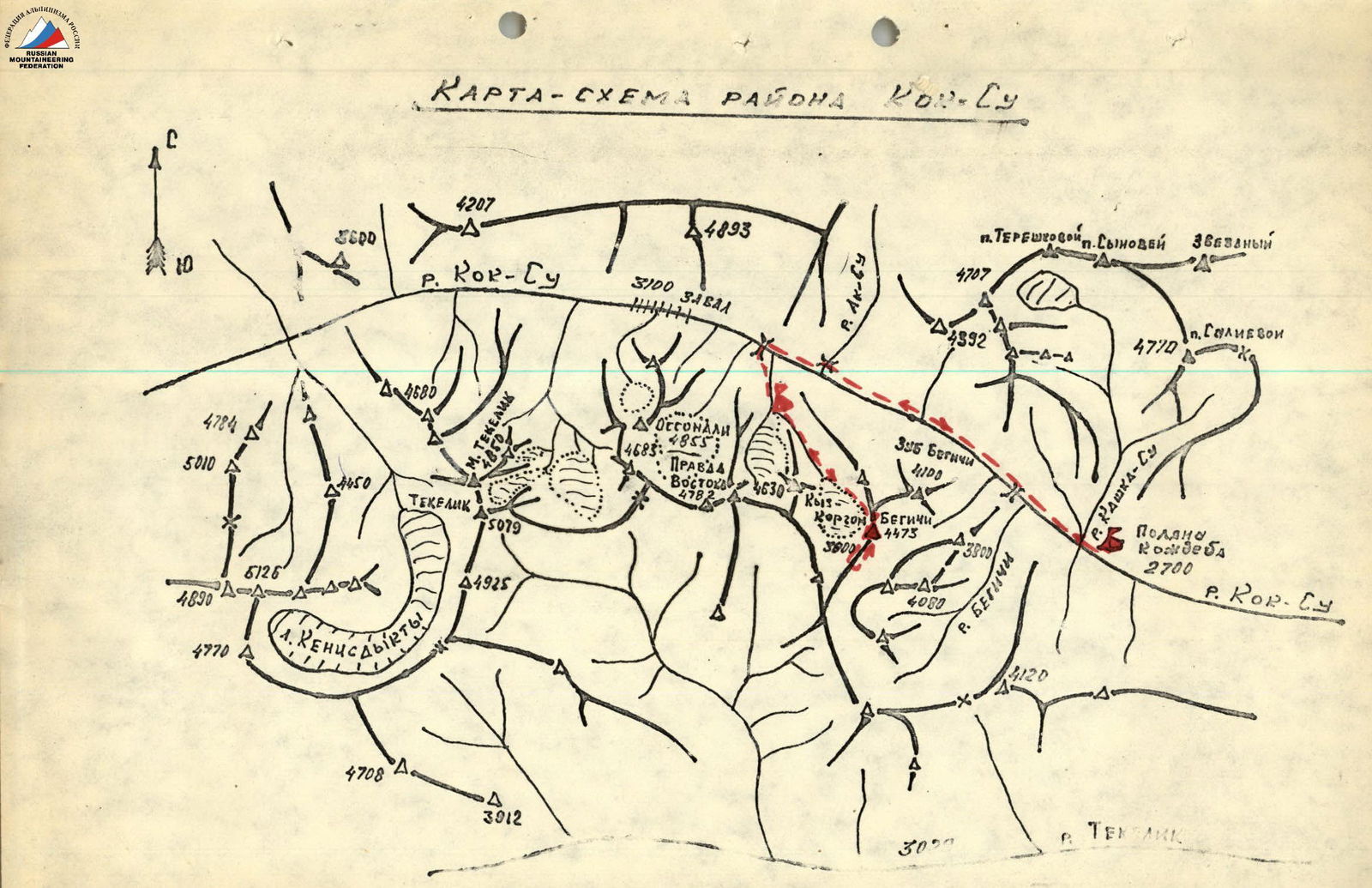
From the base camp at Kozhdeba meadow, follow the trail along the left (orographically) bank of the Kok-Su River to the 2nd bridge (2 hours 30 minutes from the camp).
Cross the bridge and ascend along the Shakhdara stream to the cirque under Kyz-Korgon Peak (4630 m), where you set up a bivouac (4 hours 30 minutes from the camp). From the bivouac, ascend along the left (in the direction of travel) stream to the glacier between the ridges of Begich and Kyz-Korgon Peaks. Traverse the glacier (in teams), bypassing the western ridge of Begich Peak, and exit to the upper cirque of the glacier. From the upper cirque, approach the reddish counterfort of the Southwest ridge, orienting towards the triangular wall formed on the left by a chimney and on the right by a snow-ice couloir. The journey from the bivouac takes 3 hours.
Ascend to the triangular wall's summit, moving left-up along a ledge, then right-up through a cleft (40 m), and then along the ridge (40 m). Use piton belays. On the triangle's summit, there's a control cairn.
From the cairn, ascend directly up a wide, steep (40°) scree couloir, then along rocky ridges, exiting under the base of the large reddish triangular wall (120 m). From here, move right, then directly up along the right rocky wall of a narrow snow-ice couloir, exiting onto the counterfort ridge (40 m). Use piton belays and natural features for protection. The journey from the start of the route takes 2 hours. Along the counterfort ridge, navigate through a series of short (3–4 m) rocky walls and inclined ledges, bypassing a large gendarme on the right (in the direction of travel), and exit onto the Southwest ridge of the peak, under the base of a rocky ascent (80 m).
From the base of the rocky ascent, move directly up along its right side, ascending a vertical wall (10 m) to reach a sharp rocky ridge. Along this ridge (15 m), access the next wall (6–8 m), and then exit onto the shoulder of the rocky ascent (80 m).
From the shoulder, navigate through a system of short (2–3 m) walls and ledges to reach a gendarme (120 m, with piton belays). Ascend the gendarme on its right side, using narrow inclined ledges, until reaching its middle part (40 m). Then, traverse along a narrow ledge (15 m, with piton belays) and descend into a gap to the base of the pre-summit gendarme (40 m). Along the rocks on the right (in the direction of travel) side of the gendarme, bypass it, and exit onto the pre-summit ridge (80 m).
From here, traverse right into a scree couloir formed by the junction of the Southwest and South ridges, and exit towards the pre-summit tower (80 m). Along the tower, through easy rocks, reach the summit (40 m).
The journey from the start of the route takes 7 hours. Descend from the summit towards the North ridge along slabs to a wide ledge (40 m). From here, make a "sporting" descent (30 m) to a saddle on the North ridge.
From the saddle, descend directly down along a wide, gentle scree into the upper cirque of the glacier under Begich and Kyz-Korgon Peaks. The journey from the summit takes 1 hour 30 minutes.
| № | Designation | Average Steepness, degrees | Length, m | Relief Characteristics | Difficulty | Condition | Weather Conditions | Rock Pitons | Ice | Ropes |
|---|---|---|---|---|---|---|---|---|---|---|
| 1 | 2 | 3 | 4 | 5 | 6 | 7 | 8 | 9 | 10 | 11 |
| 07.78 | R0–R1 | 50° | 80 | Wall, steep slabs, ridge | IV | Monolithic | good | 4 | - | - |
| R1–R2 | 30° | 120 | Steep slabs covered with scree | III | heavily fragmented slabs | «-» | 3 | - | - | |
| R2–R3 | 50° | 40 | Narrow snow couloir, rocky wall | IV | Monolithic | «-» | natural | - | - | |
| R3–R4 | 30° | 80 | Ridge with gendarme, short walls (3–4 m), ledges | III | weakly fragmented rocks | «-» | ± | - | - | |
| R4–R5 | 45° | 200 | Rocky ascent, walls 6–8 m, ridges, ledges | III | «-» | «-» | 3 | - | - | |
| R5–R6 | 20° | 160 | Rocky ridge, inclined ledges, easy rocks | II | fragmented rocks | «-» | - | - | 1 | |
| R6–R7 | 15° | 80 | Wide scree couloir | I | scree | «-» | - | - | - | |
| R7–R8 | 30° | 40 | Summit tower, stepped rocks | II | weakly fragmented rocks | «-» | - | - | - |