Ascent Passport
Appendix I
I. Ascent class — technical
II. Ascent area — Southern spurs of Alay mountain range
III. Peak, its height, and ascent route — Aydarbek 5127 m via N-E wall, route "SHAGINYAN" by A. DMITRIEV, 78
IV. Proposed difficulty category — 5B
V. Route characteristics:
- Height difference — 1100 m
- Average steepness — 60°
- Length of sections: 2 m, 3 m, 4 m, 5 600 m, 6 m
- Number of pitons for protection to create belays:
- Rock pitons — 30
- Ice pitons — 4
- Bolt pitons — 0
-
Total climbing time — 24 hours
-
Number of bivouacs and their characteristics:
- One bivouac — lying down.
- Surname of the leader and participants, their sports qualification:
- Climbing pair:
- Lopatnikov Vladimir Vasilievich — CMS
- Neverov Valerov Nikolaevich — CMS
-
Team coach — Agranovsky G. L. — Master of Sports of the USSR
-
Date of departure and return: July 20-21, 1979
Note:
- Total length of sections from I to VI difficulty category in meters.
- The passport is to be filled on a Whatman paper sheet of size 297×210. On the back of the passport, a photograph of the peak with the route and all previously climbed routes marked on it should be glued, size 18×24 cm.
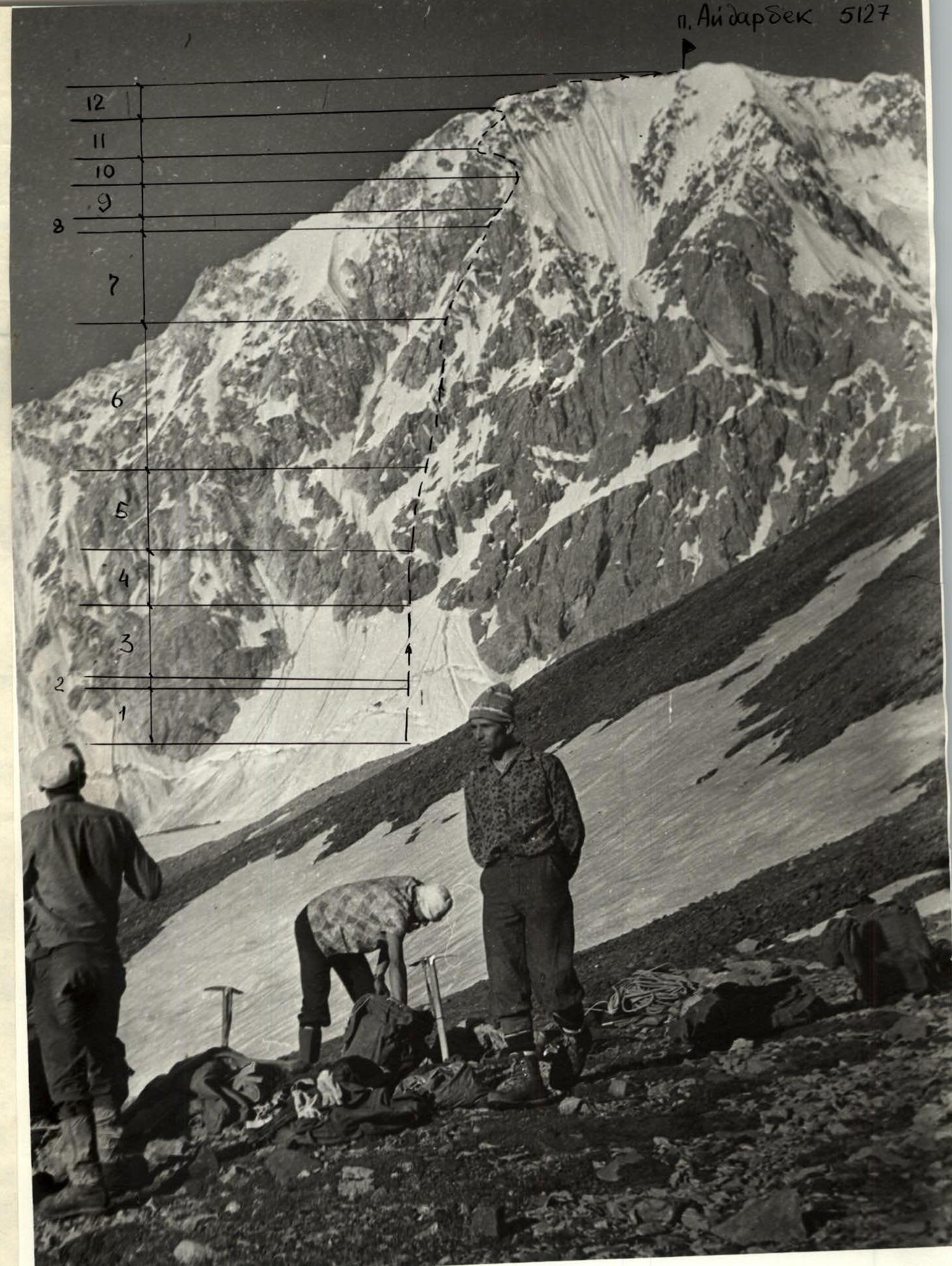
p. Aydarbek 5127
- Photograph taken on July 16, 1979.
- The peak of Aydarbek is not visible.
- The amount of snow on the route decreased by July 20.
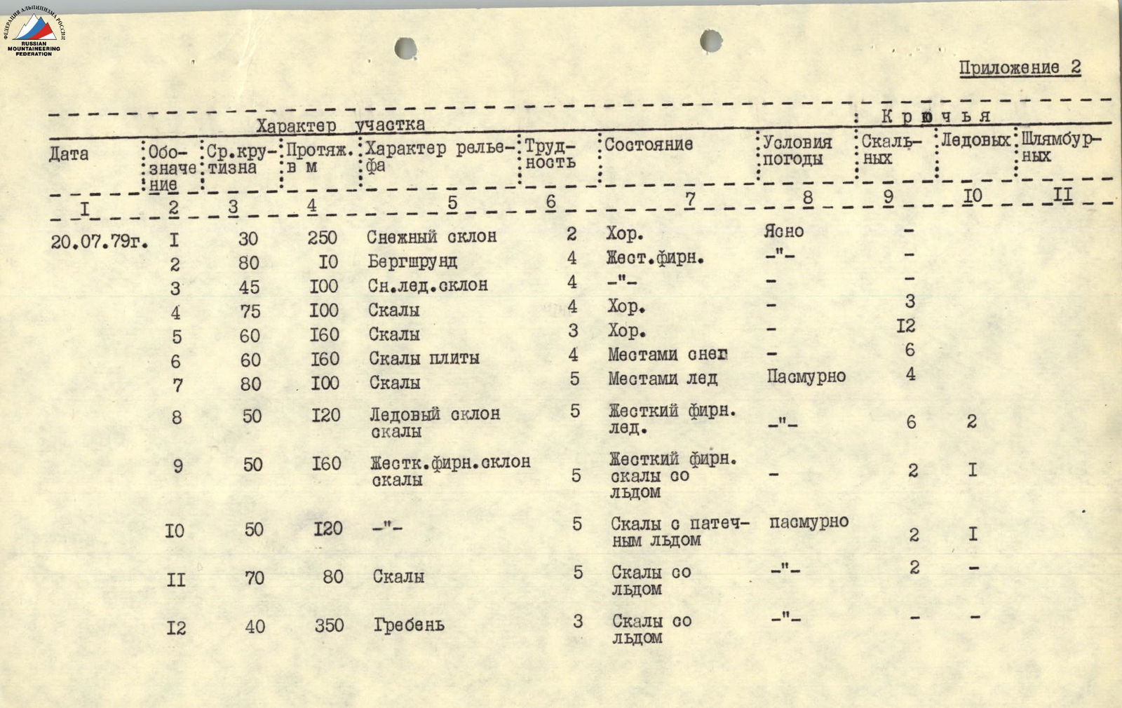
Appendix 2
| Date | Section | Avg. steepness | Length, m | Terrain characteristics | Diff. | Condition | Weather | Rock pitons | Ice pitons | Bolt pitons |
|---|---|---|---|---|---|---|---|---|---|---|
| 20.07.1979 | R1 | 30° | 250 m | Snow slope | 2 | Good | Clear | 0 | 0 | 0 |
| R2 | 80° | 10 m | Bergschrund | 4 | Hard névé. | — | 0 | 0 | 0 | |
| R3 | 45° | 100 m | Snow-ice slope | 4 | — | — | 0 | 0 | 0 | |
| R4 | 75° | 100 m | Rocks | 4 | Good | — | 3 | 0 | 0 | |
| R5 | 60° | 160 m | Rocks | 3 | Good | — | 12 | 0 | 0 | |
| R6 | 60° | 160 m | Rock slabs | 4 | Some snow | — | 6 | 0 | 0 | |
| R7 | 80° | 100 m | Rocks | 5 | Some ice | Cloudy | 4 | 0 | 0 | |
| R8 | 50° | 120 m | Ice slope, rocks | 5 | Hard névé., ice. | — | 6 | 2 | 0 | |
| R9 | 50° | 160 m | Hard névé slope, rocks | 5 | Hard névé., rocks with ice | — | 2 | 1 | 0 | |
| R10 | 50° | 120 m | — | 5 | Rocks with ice | Cloudy | 2 | 1 | 0 | |
| R11 | 70° | 80 m | Rocks | 5 | Rocks with ice | — | 2 | 0 | 0 | |
| R12 | 40° | 350 m | Ridge | 3 | Rocks with ice | — | 0 | 0 | 0 |