«Technical Class»
Report
URAL MILITARY DISTRICT TEAM'S ASCENT OF PIK AYDAREK (5127 m) VIA THE NORTH FACE (GINZBURG'S ROUTE) - THIRD ASCENT
| TEAM LEADER ZADVORYEV YU. V. | – Candidate Master of Sports |
|---|---|
| KAZANTSEV S. K. | – 1st sports category |
| PAKHOMOV V. D. | – 1st sports category |
| TARKHOV E. V. | – Candidate Master of Sports |
| YAKOVLEV V. D. | – Master of Sports |
1981
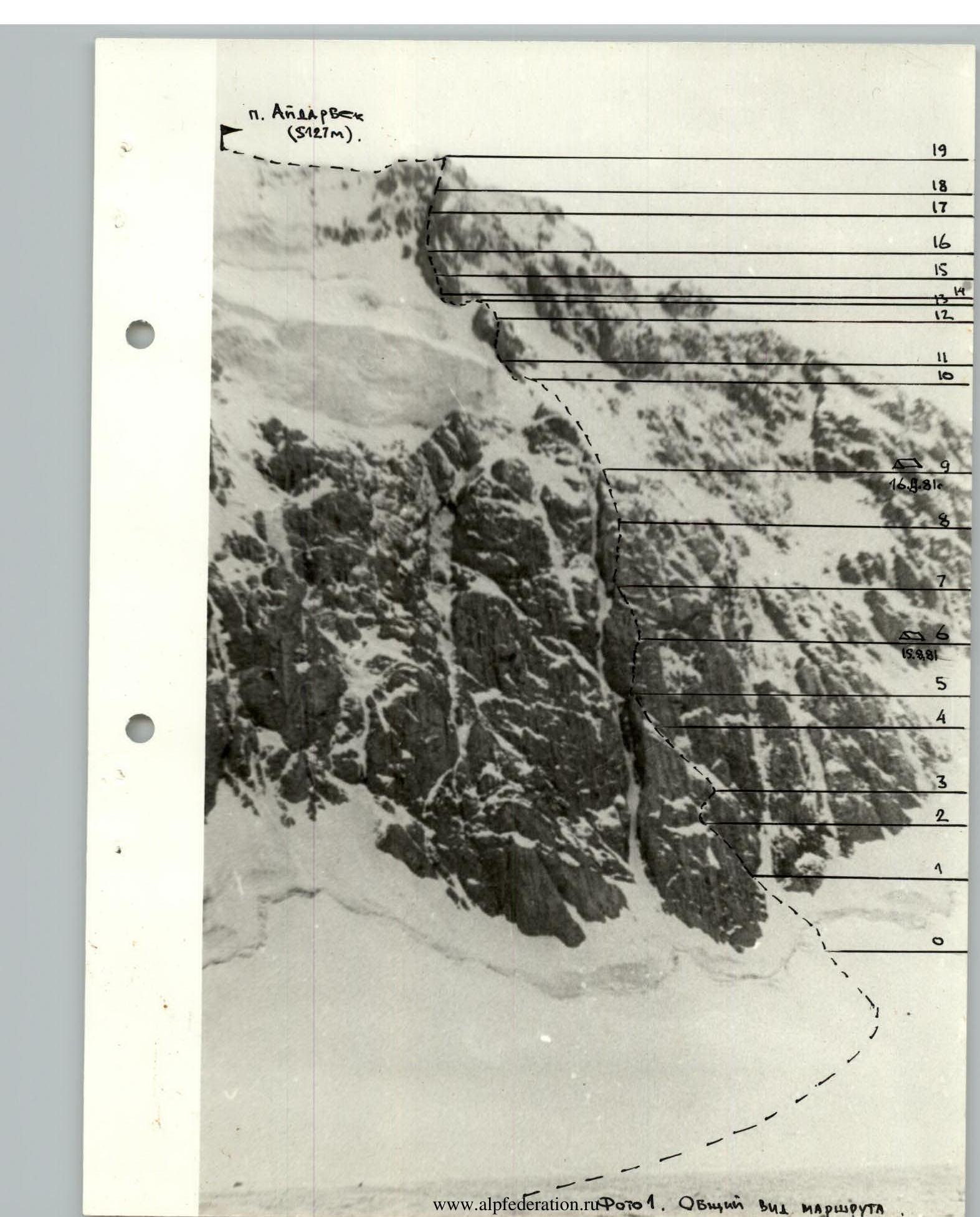 Photo 1. General view of the route
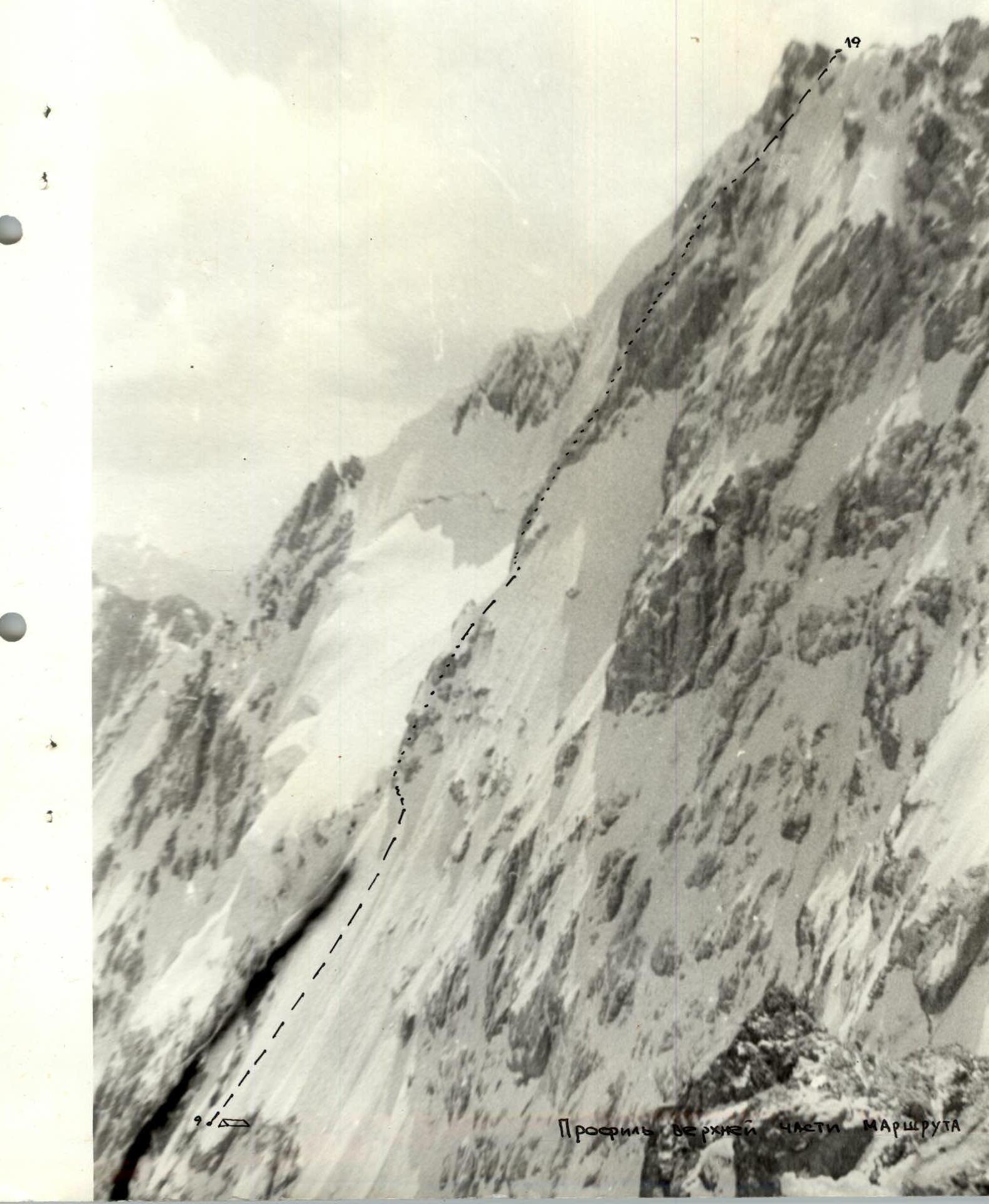 Profile of the upper part of the route
Table of main characteristics of the ascent route
| Characteristic | Hooks | ||||||||
|---|---|---|---|---|---|---|---|---|---|
| I | 2 | 3 | 4 | 5 | 6 | 7 | 8 | 9 | 10 |
| Date: August 15, 1981 | |||||||||
| R0–R1 | 55 | 80 | Bergschrund, ice slope | 5 | Firm snow turning into pure ice | good | 3 | 6 | - |
| R1–R2 | 70 | 60 | Gully | 5 | Ice on the wall of the gully, ice on the wall | — " — | 6 | 4 | - |
| R2–R3 | 80 | 80 | Wall | 6 | Monolith, few cracks on the wall, ice | — " — | 10 | 1 | - |
| R3–R4 | 55 | 80 | Ice belt, gully | 6 | Ice on rocks | — " — | 5 | 7 | - |
| R4–R5 | 80 | 40 | Wall, crack | 5 | Wall with limited number of holds | — " — | 8 | - | - |
| R5–R6 | 80 | 80 | Overhanging "forehead", wall | 6 | Monolith, difficulty in choosing a belay spot | — " — | 8 | 2 | 1 |
| Summary of the day: departure time - 9:30; arrival time at bivouac - 19:30; total climbing hours on the 1st day - 10 hours; bivouac conditions - uncomfortable, 2+2+1. | |||||||||
| Date: August 16, 1981 | |||||||||
| R6–R7 | 80 | 60 | Crack, slabs, overhanging "nose" | 6 | Icy slabs, monolithic rocks | good | 8 | 11, 1 | 1 |
| R7–R8 | 75 | 70 | Wall, crack | 6 | Icy rocks, crack with ice | average, snow charge | 9, 11 | 2 | - |
| R8–R9 | 75 | 60 | Inner corner | 6 | Icy rocks | visibility worsening, snow | 9, 11 | 4 | - |
| Summary of the day: departure time - 9:30; arrival time at bivouac - 18:30; total climbing hours on the 2nd day - 9 hours; bivouac conditions: sitting, 2+3. | |||||||||
| Date: August 17, 1981 | |||||||||
| R9–R10 | 55 | 150 | Ice board | 5 | Ice with a small amount of snow | good | - | 12 | - |
| R10–R11 | 60 | 90 | Ascent | 5 | Ice | — " — | 3 | 7 | - |
| R11–R12 | 75 | 80 | Chimney, wall | 5 | Monolith, ice wall | — " — | 5 | 6 | - |
| R12–R13 | 55 | 80 | Ice slope, ridge | 5 | Ice, snow | — " — | 4 | 6 | - |
Continuation of the route characteristics table
| I | 2 | 3 | 4 | 5 | 6 | 7 | 8 | 9 | 10 |
|---|---|---|---|---|---|---|---|---|---|
| R13–R14 | 80 | 50 | Traverse along the edge of rocks and ice | 6 | Icy rocks, ice with a small amount of snow | good | 6 | 3, 1 | - |
| R14–R15 | 60 | 60 | Walls, shelves | 4 | System of small walls, snowy shelves | — " — | 8 | - | - |
| R15–R16 | 80 | 40 | Chimney | 5 | Icy walls | weather worsening | 6 | - | - |
| R16–R17 | 80 | 80 | Wall | 5 | Monolith, few holds | bad, snow, wind | 10 | - | - |
| R17–R18 | 50 | 50 | Wall, couloir | 5 | Overhanging wall, snowy, destroyed | clouds breaking | 6 | 2, 11 | - |
| R18–R19 | 60 | 80 | Ice "forehead", crack | 4 | Snowy | bad | 6 | 3 | - |
| R19–R20 | 20 | 250 | Ridge | 2 | Rocks, ice, snow | wind | - | - | - |
Summary of the day: — Departure time - 9:40 — Arrival time at the summit - 19:40 — Total climbing hours - 10 hours — Bivouac conditions: lying, 2+3
Note: the numbers in the table denote the following sections: — 1 — section designation — 2 — average steepness, degrees — 3 — length, m — 4 — terrain type — 5 — difficulty, category — 6 — section condition — 7 — weather conditions — 8 — rock hooks — 9 — ice hooks — 10 — bolt hooks
Roman numerals in the "hooks" section denote the number of hooks used for artificial climbing holds.
Explanations for the table of main characteristics of the route
R0–R1. Firn slope, crossing the bergschrund (100 m to the right of the chimney), exit to the ice slope and left-up to the ice gully; crampons.
R1–R2. Up the gully. Ice is accumulated. Ice and rock hooks. Belay on a rock shelf.
R2–R3. Inner corner (20 m). Traverse right under the overhang, exit to the ice belt. Difficulty with belay.
R3–R4. Traverse left (30 m), ice, gully, and left along the ice shelf to the chimney crossing the entire wall.
R4–R5. Up the wall to the right of the chimney along the red crack, approach under the "overhanging 'forehead'".
R5–R6. The "forehead" is overcome directly upwards (bolt hook!) for belay along a small crack, traverse 2 m left and up the right edge of the chimney wall. Rocks are monolithic. Exit right onto a shelf. Here was a sitting bivouac (2+2+1).
R6–R7. From the bivouac up the wall left-upwards (another bolt hook was driven for belay) to a 1x1 m platform, exit to which is through a crack filled with ice. Exit up the wall 10 m, then up the slabs under the "overhanging 'nose'". The "nose" is overcome directly upwards along the left part using artificial climbing holds (rope ladders), exit to a narrow long shelf (6 m).
R7–R8. From the right end of the shelf up the wall and through the crack exit to a platform.
R8–R9. From the platform up the inner corner and along a small ridge to the exit onto the ice board. Here was the 2nd bivouac (2+3).
R9–R10. Up the ice board on crampons left-upwards onto the ice ridge and to the rocks of the upper part of the wall (150 m, steepness up to 55°).
R10–R11. Bypassing the rocks on the left upwards 90 m to a pronounced chimney.
R11–R12. Up the chimney right-upwards 40 m to a small rock platform, then bypassing the ascent on the right through a steep ice wall (5 m) onto a scree platform.
R12–R13. Left-upwards along the destroyed wall (20 m), along the ice slope exit to a sharp ice ridge and upwards to the rocks (40 m).
R13–R14. Traverse 50 m left along the edge of rocks and ice. Accumulated ice.
R14–R15. Up the rocks (destroyed!) 60 m.
R15–R16. Up the chimney 40 m (caution, large loose rocks!).
R16–R17. Up the monolithic rocks with cracks to a short overhanging wall.
R17–R18. Further exit to a rock, heavily destroyed couloir and upwards exit right onto a rock-ice ridge.
R18–R19. Up the ridge 20 m to the ice "forehead", 20 m traverse left, transition to a rock crack and up 40 m. Exit to the West ridge of Pik Aydapek. End of the wall.
R19–R20. Along the gentle ridge left to the summit (250 m, about half an hour).
Senior coach of the UrVO team (Mikhaylov) Team captain (Zadvoryev)

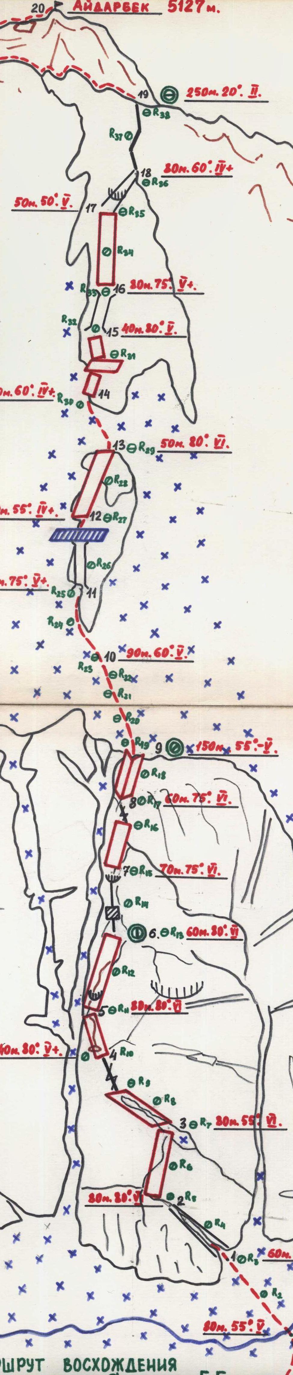 ROUTE OF THE ASCENT OF PIK AYDARBEK VIA THE NORTH FACE 5-6 category of difficulty