Ascent Log
-
Climbing category: technical.
-
Pamir-Alay.
-
Peak Aidarbek, 5127 m, via the north face.
-
6th category of difficulty.
-
Route characteristics:
Combined, height difference 1100 m (wall part 1010 m), average slope of the wall 70°, length of sections:
- 1st category of difficulty — none
- 2nd category of difficulty — 250 m
- 3rd category of difficulty — none
- 4th category of difficulty — 220 m
- 5th category of difficulty — 650 m
- 6th category of difficulty — 540 m
-
Pitons hammered: for belaying, for creating artificial anchors:
- rock pitons 166 pcs.
- ice screws 63 pcs.
- bolt pitons 6 pcs.
-
Number of climbing hours: 63 hours.
-
Number of nights spent: sitting — 3, lying — 1.
-
Team leader: Ginzburg Vladimir Isaakovich, Candidate Master of Sports.
Team members:
- Bashkirov Vladimir Leonidovich, Candidate Master of Sports.
- Zaid Pavel Vulfovich, Master of Sports.
- Staritsky Petr Ivanovich, Candidate Master of Sports.
-
Team coach: Naumov Alexander Fedorovich, Master of Sports.
-
17–24 August 1977.
Introduction
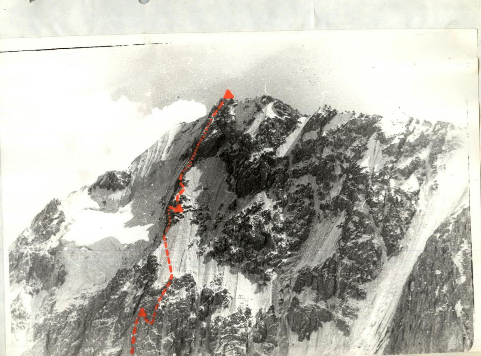
Peak Aidarbek (5127 m) is located in the southern spur of the Alay Range, in the Koksu river basin. To the north and northeast, the peak drops with steep, icy walls with a height difference of up to 1000 m. Aidarbek already has several routes:
- 4A category of difficulty via the western ridge,
- 5A category of difficulty via the northern counterfort,
- two 5B category of difficulty routes via the northeastern wall.
The north face remained unconquered, and we chose it as our ascent objective.
There are two possible approaches to the north face of Peak Aidarbek:
- either via the Alauddin pass from Dugoba (two days' journey),
- or via Darut-Kurgan from the Alay Valley.
From Darut-Kurgan, a car road leads to the Kozhdeba meadow, and then it's a 5-hour walk up the Koksu valley to the geologists' base, and another 3 hours up the left tributary valley to the wall, to the start of the route.
The north face of Aidarbek is primarily composed of marble. For climbers, this means fewer cracks for pitons and a specific type of handhold that is difficult to use for climbing (reverse handholds).
The climatic conditions in the Peak Aidarbek area are satisfactory in summer: bad weather occurs with a frequency of 2–3 times a month and lasts no more than two days. In late August, bad weather can last longer. Strong winds often blow along the Koksu valley, especially in the afternoon.
The option to ascend via the north face did not spark a long debate: the overhanging ice couloir above the left part of the wall ruled it out. The extreme right part of the wall was exposed to rockfall in the afternoon, and it is also less steep than the central part.
Thus, only the central part of the wall remained — the steepest, most extensive, but safest section, where it is intersected by a huge, icy chimney stretching up to 500 m. The safe section of the wall is only 150 m wide, to the right of the chimney. The chimney itself is exposed to rockfall from above.
After observing the route, it became clear that the key section would be the lowest part, immediately from the bergschrund to the large ice ledge (500 m height difference). The average slope of this section is up to 80°, then the wall becomes slightly gentler, around 65°, and before reaching the ridge, it becomes steeper again, up to 70°. Thus, the average slope of the wall with a 1000 m height difference is 70°. After reaching the ridge, there are 300 m remaining to the summit along a gentle ridge — a section of 4A category of difficulty.
Route Description
Approach to the bergschrund via a snowy slope with increasing steepness. In the upper part, the snow slope is up to 60° steep, requiring step-kicking. The bergschrund is crossed at the point of the smallest gap between the edges, 100 m to the right of the chimney. It is recommended to pass this point before 13:00, as the upper part of the route is intensely exposed to the sun afterwards, and rockfall begins.
Transition to the wall from the bergschrund is made via a thin ice bridge "astride." From the 5 m long bridge (step-kicking, artificial anchors). Then, exit to an ice slope with a steepness of 50° to 55° and left-up towards a frozen gully. The ice has a crust of superimposed ice that peels off in lenses when chopped, making it difficult to move on front points of crampons — step-kicking is necessary.
Exit to rocks under the gully. Here is a belay anchor point. End of section R0–R1 (80 m, 14 ice screws and 2 rock pitons hammered).
Further up the gully. Belaying is mostly to the left edge of the gully. Step-kicking. The ice in the gully is superimposed, and when screwing in ice screws, it breaks off.
At the top of the gully, exit to the rocks of the left edge and up to a ledge. End of section R1–R2 (60 m, 6 rock pitons and 5 ice screws hammered).
Section R2–R3 starts with a 20 m long internal corner filled with ice. Steepness 80°, "reverse" handholds, few cracks for pitons. Then, a 30 m traverse to the right under a slight overhang and exit up frozen, iced rocks to an ice belt. It is very difficult to organize belaying due to the small number of cracks. Total length of the section 80 m, steepness 80°. 11 rock pitons and 2 ice screws hammered.
Section R3–R4. Traverse left 30 m across ice with a steepness of 50°, then up a gully filled with ice, steepness 60° to 70° (120 m), artificial anchors, step-kicking. Then, a steep ice ledge traverse left 30 m to the chimney crossing the entire lower part of the wall. Rocks and ice fall down the chimney. Length of the section 80 m. 10 rock pitons and 6 ice screws hammered. Processing this section took 15 hours in total.
Section R4–R5. Up the wall, a few meters to the right of the chimney, directly towards the red cleft and through it (loose rocks!):
- 10 m — approach to the overhanging "brow"
- 40 m, 80°, 6 rock pitons.
Section R5–R6. The overhanging "brow" is overcome directly up a small crack (artificial anchors, 5 m). Then, 2 m traverse left across a sheer wall and up the right edge of the chimney wall. Rocks are very monolithic, average steepness of the section 80°, length 80 m. 17 rock pitons hammered.
At the end of this section, on a small ledge, a sitting bivouac was organized: three people together, one separately. From the bergschrund, this is probably the first ledge where one can settle relatively "comfortably" and safely.
Section R6–R7. From the bivouac up the cleft. Entrance to the cleft on artificial anchors, slightly overhanging. The cleft is partially filled with ice. After 20 m, it leads into the main chimney, to a 1 m × 1 m platform. Sometimes, rocks ricochet here. Then, 10 m up the right side of the chimney and exit to the right onto the wall. From here, directly up steep slabs without cracks 20 m to an overhanging "nose." The "nose" is passed using artificial anchors. From the tip of the "nose" to the right, there is a long (6 m) narrow (0.4 m) ledge where a sitting bivouac can be organized. Steepness of the section 80°, length 60 m, 22 rock pitons hammered.
Section R7–R8. From 10:00, the weather deteriorated — heavy snow started falling.
From the right end of the long ledge up monolithic iced rocks 40 m to a narrow cleft. The cleft (30 m) is passed mainly on artificial anchors. Wooden wedges or very wide flanges are necessary here. At the end of the section, a platform where the tent was partially set up and a sitting bivouac was organized. Average steepness of the section 75°, length 70 m, 24 rock pitons hammered.
Section R8–R9. From the bivouac, traverse right 10 m along the ledge to a pit. Then, 15 m sport climbing down into an ice couloir, and, crossing it, directly up 40 m along an internal corner to ice-covered smoothed rocks. Up these to a cornice and, leaving it to the left, along an internal corner 50 m to the exit onto an ice ledge. Despite the relatively small steepness of the section (65°), passing it took a lot of time due to ice in cracks for pitons. It is worth noting that a 15 m "brow" (50°) in the middle of the section took 2 hours. Total: 28 rock pitons and 3 ice screws hammered. The "brow" was passed using artificial points of support.
Section R9–R10. Up the ice ledge on front points of crampons with a slight traverse left onto an ice ridge leading to the rocks of the upper part of the wall. Total 150 m, average steepness 55°, 18 ice screws and 2 rock pitons hammered.
Section R10–R11. From the ice ridge, bypassing rocks on the left along the boundary between the ice rise and rocks, up 90 m to a pronounced chimney. Average steepness of the slope 60°. 9 rock pitons and 3 ice screws hammered.
Section R11–R12. Up the chimney to the right 40 m (loose rocks!) and exit to a small rock outcrop. From it, bypassing a monolithic rock rise on the right, exit to a talus platform through a sheer ice wall (5 m), artificial anchors. Total 80 m, steepness 75°, 7 rock pitons and 6 ice screws hammered. A sitting bivouac was organized here in a partially set-up tent.
Section R12–R13. From the bivouac left-up along a destroyed cleft 20 m, then along an ice slope 20 m, exit to the tip of an ice ridge. Along the ridge 40 m up to rocks. Average steepness of the section 55°, 3 rock pitons and 6 ice screws hammered.
Section R13–R14. Traverse 50 m left along the edge of rocks and ice. Destroyed rocks filled with superimposed ice. Average steepness 80°. 14 rock pitons and 2 ice screws hammered.
Section R14–R15. Up very destroyed rocks with a steepness of 60° directly 60 m. 5 rock pitons hammered.
Section R15–R16. Further up the chimney 40 m. Large "live" rocks lie here. Steepness 80°. 6 rock pitons hammered.
Section R16–R17. Up monolithic rocks with cracks 80 m to a short overhanging wall. Large icicles nearby.
Section R17–R18. Through the overhanging wall (3 m, artificial anchors) exit to a rocky, heavily destroyed couloir and along it to a rock-ice ridge. Total 50 m, steepness 50°, 10 rock pitons hammered.
Section R18–R19. Up the rocks of the ridge 20 m to an ice "brow." Across it 20 m traverse, transition to a rock cleft and along it 40 m. Exit to the western ridge of Aidarbek. End of the wall. On the ridge — a lying bivouac.
Section R19–R20. Along a gentle talus ridge with rock outcrops to the summit 250 m.
Table of Section Characteristics
| Date | Section | Average steepness | Length | Terrain characteristics | Category of difficulty | Surface condition | Weather conditions | Rock pitons | Ice screws | Bolt pitons |
|---|---|---|---|---|---|---|---|---|---|---|
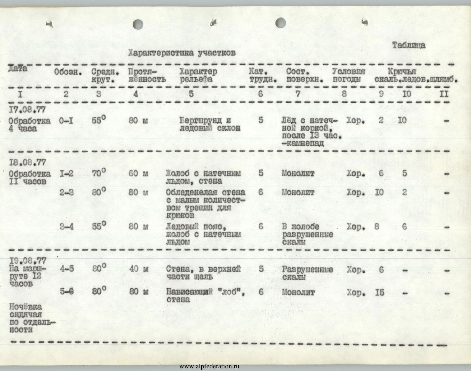
| 17.08.1977 | R0–R1 | 55° | 80, m | Bergschrund and ice slope | 5 | Ice with superimposed ice crust | Good, rockfall after 13:00 | 2 | 10 | – |
| Processing 4 hours | ||||||||||
| 18.08.1977 | R1–R2 | 70° | 60, m | Gully with superimposed ice, wall | 5 | Monolith | Good | 6 | 5 | – |
| Processing 11 hours | ||||||||||
| R2–R3 | 80° | 80, m | Iced wall with few cracks for pitons | 6 | Monolith | Good | 10 | 2 | – | |
| R3–R4 | 55° | 80, m | Ice belt, gully with superimposed ice | 6 | Destroyed rocks in the gully | Good | 8 | 6 | – | |
| 19.08.1977 | R4–R5 | 80° | 40, m | Wall, cleft at the top | 5 | Destroyed rocks | Good | 6 | – | – |
| 12 hours on the route | ||||||||||
| R5–R6 | 80° | 80, m | Overhanging "brow", wall | 6 | Monolith | Good | 17 | – | – | |
| Sitting bivouac | ||||||||||
| 20.08.1977 | R6–R7 | 80° | 60, m | Iced cleft, slabs, overhanging "nose" | 6 | Monolith | Bad, heavy snow, visibility 80 m | 22 | – | – |
| 11 hours on the route | ||||||||||
| Sitting bivouac together | ||||||||||
| 21.08.1977 | R7–R8 | 75° | 70, m | Iced wall, cleft | 6 | Monolith | Bad, same | 24 | – | – |
| 11 hours on the route | ||||||||||
| R8–R9 | 65° | 120, m | Iced internal corner, exit to ice ledge | 6 | Rocks covered with thick ice layer | Good | 28 | 3 | – | |
| R9–R10 | 55° | 150, m | Ice ledge | 5 | Solid ice | Good | 2 | 18 | – | |
| R10–R11 | 60° | 90, m | Ice rise | 5 | Belaying to rocks | Good | 9 | 3 | – | |
| R11–R12 | 75° | 80, m | Chimney, ice wall | 5 | Destroyed rocks | Good | 7 | 6 | – | |
| Sitting bivouac together | ||||||||||
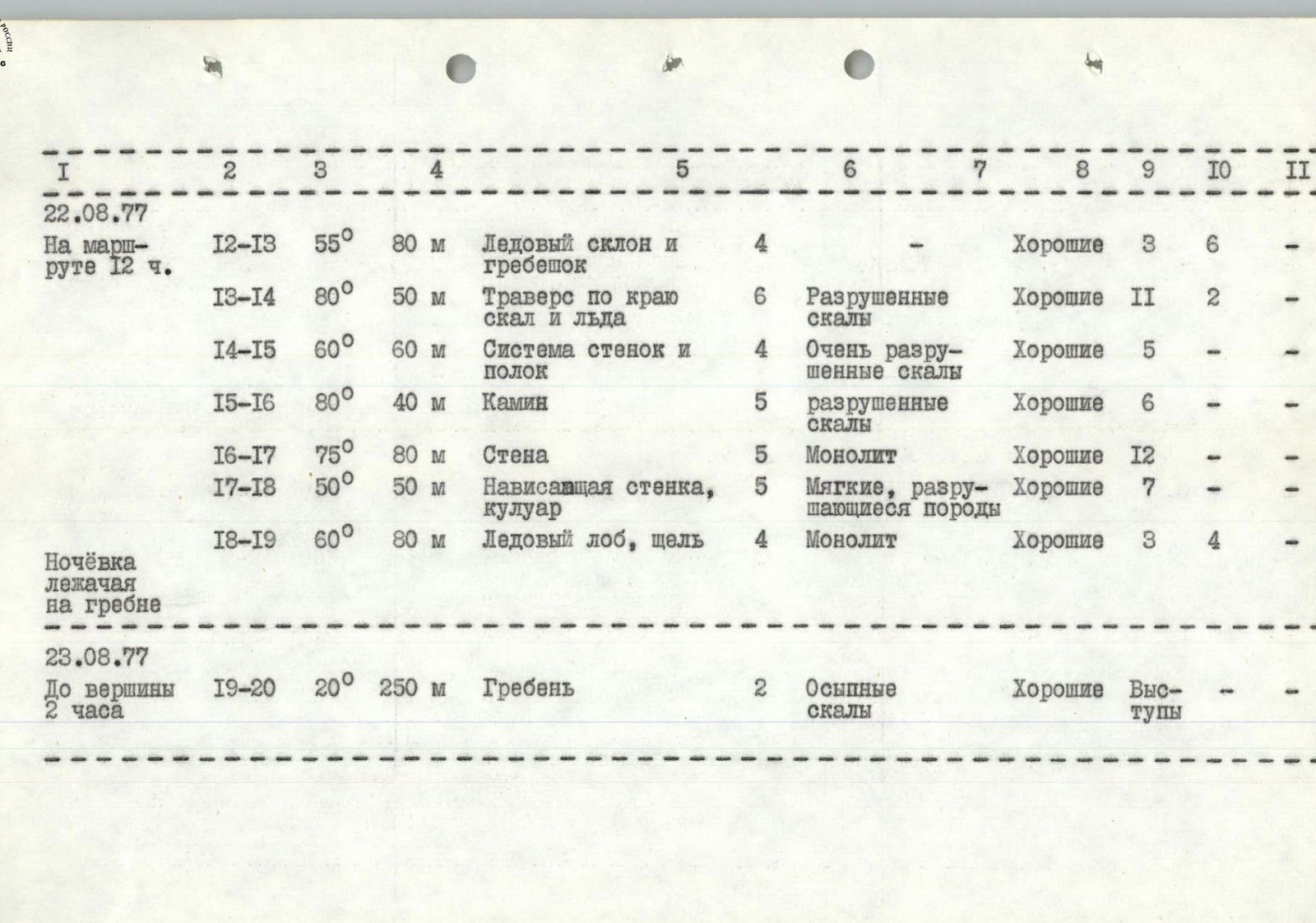
| 22.08.1977 | R12–R13 | 55° | 80, m | Ice slope and ridge | 4 | – | Good | 3 | 6 | – |
| 12 hours on the route | ||||||||||
| R13–R14 | 80° | 50, m | Traverse along the edge of rocks and ice | 6 | Destroyed rocks | Good | 14 | 2 | – | |
| R14–R15 | 60° | 60, m | System of walls and ledges | 4 | Very destroyed rocks | Good | 5 | – | – | |
| R15–R16 | 80° | 40, m | Chimney | 5 | Destroyed rocks | Good | 6 | – | – | |
| R16–R17 | 75° | 80, m | Wall | 5 | Monolith | Good | 12 | – | – | |
| R17–R18 | 50° | 50, m | Overhanging wall, couloir | 5 | Soft, crumbling rocks | Good | 10 | – | – | |
| R18–R19 | 60° | 80, m | Ice "brow", cleft | 4 | Monolith | Good | 3 | 4 | – | |
| Lying bivouac on the ridge | ||||||||||
| 23.08.1977 | R19–R20 | 20° | 250, m | Ridge | 2 | Talus rocks | Good | – | – | – |
| To the summit 2 hours |