Ascent Passport
- Ascent class: technical
- Ascent area: Pamir-Alay, Alay Ridge
- Peak, its height, and ascent route: Shait, 4916 m, via North-Eastern wall (by Mogilevtsev's path), qualifying route
- Proposed difficulty category: 5B cat. diff.
- Route characteristics:
Height difference 850 m, average steepness 67°. Length of sections:
- 1st cat. diff. — 40 m
- 3rd cat. diff. — 300 m
- 4th cat. diff. — 375 m
- 5th cat. diff. — 270 m
- 6th cat. diff. — 135 m
Pitons driven:
- For belaying:
- Rock: 65
- Ice: 2
- Protection devices: 56
- For creating anchor points:
- Rock: 2
- Protection devices: 4
- Number of climbing hours: 18 hours
- Number of bivouacs and their characteristics: no bivouacs
- Surname, name, patronymic of the leader and participants, their sports qualification:
Sereda Vladimir Alexandrovich, Candidate Master of Sports Kurmachov Yuri Fedorovich, Candidate Master of Sports
-
Team coach: Yakovlev Vitaly Dmitrievich, senior instructor, Master of Sports of the USSR
-
Date of departure and return:
-
July 17, 3:10 — departure; July 17, 23:30 — return.
Observation group:
- Sapozhnikov Yu.G., instructor, Candidate Master of Sports
- Laptenok V.D., instructor, Candidate Master of Sports

TABLE OF MAIN ROUTE CHARACTERISTICS
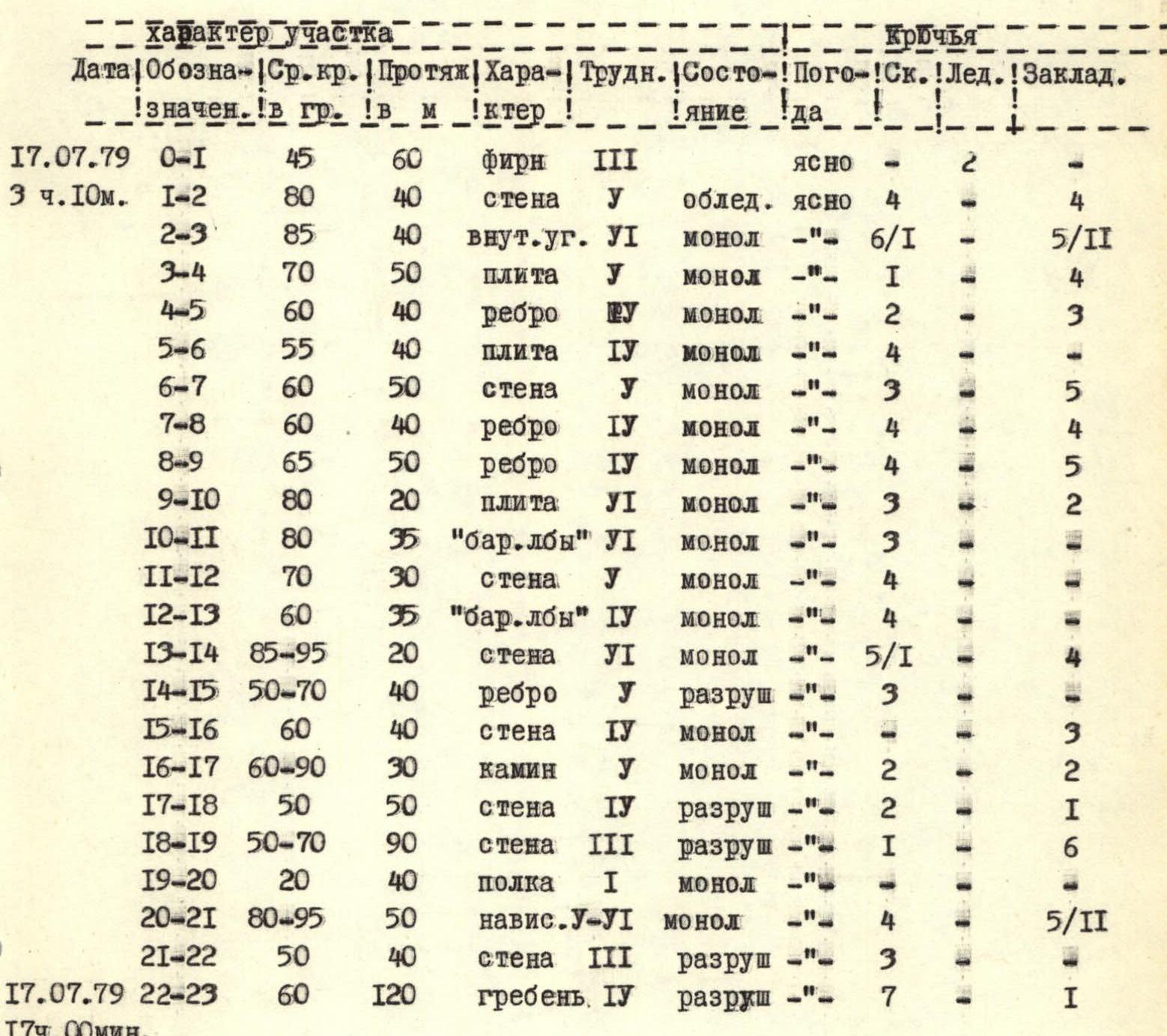
| Date | Section | Average steepness, ° | Length, m | Character | Category of difficulty of the section | Condition | Weather | Rock pitons | Ice pitons | Protection devices |
|---|---|---|---|---|---|---|---|---|---|---|
| July 17, 1979, 3:10 | R0–R1 | 45 | 60 | firn | 3 | clear | — | 2 | — | — |
| R1–R2 | 80 | 40 | wall | 5 | icy | clear | 4 | — | — | |
| R2–R3 | 85 | 40 | inner angle | 6 | monolith | —"— | 6/1 | — | 5/11 | |
| R3–R4 | 70 | 50 | slab | 1 | monolith | —"— | 1 | — | 4 | |
| R4–R5 | 60 | 40 | edge | — | monolith | —"— | 2 | — | 3 | |
| R5–R6 | 55 | 40 | slab | 4 | monolith | —"— | 4 | — | — | |
| R6–R7 | 60 | 50 | wall | 5 | monolith | —"— | 3 | — | 5 | |
| R7–R8 | 60 | 40 | edge | 4 | monolith | —"— | 4 | — | 4 | |
| R8–R9 | 65 | 50 | edge | 4 | monolith | —"— | 4 | — | 5 | |
| R9–R10 | 80 | 20 | slab | 2 | monolith | —"— | 3 | — | 2 | |
| R10–R11 | 80 | 35 | "brow" | 6 | monolith | —"— | 3 | — | — | |
| R11–R12 | 70 | 30 | wall | 1 | monolith | —"— | 4 | — | — | |
| R12–R13 | 60 | 35 | "brow" | 4 | monolith | —"— | 4 | — | — | |
| R13–R14 | 85–95 | 20 | wall | 6 | monolith | —"— | 5/1 | — | 4 | |
| R14–R15 | 50–70 | 40 | edge | 1 | destroyed | —"— | 3 | — | — | |
| R15–R16 | 60 | 40 | wall | 4 | monolith | —"— | 3 | — | — | |
| R16–R17 | 60–90 | 30 | chimney | 5 | monolith | —"— | 2 | — | 2 | |
| R17–R18 | 50 | 50 | wall | 4 | destroyed | —"— | 2 | — | 1 | |
| R18–R19 | 50–70 | 90 | wall | 3 | destroyed | —"— | 1 | — | 6 | |
| R19–R20 | 20 | 40 | ledge | 1 | monolith | —"— | — | — | — | |
| R20–R21 | 80–95 | 50 | overhang | 5–6 | monolith | —"— | 4 | — | 5/11 | |
| R21–R22 | 50 | 40 | wall | 3 | destroyed | —"— | 3 | — | — | |
| July 17, 1979, 17:00 | R22–R23 | 60 | 120 | ridge | 4 | destroyed | —"— | 7 | — | 1 |
Brief explanation for the table
| Section | Explanation |
|---|---|
| R0–R1 | Firn with ice, bergschrund 1 m. |
| R1–R2 | Icy rocks, partially destroyed, good cracks. |
| R2–R3 | Exit to the rib slabs, well-used protection devices. |
| R3–R4 | Slabs with small ledges. |
| R4–R5 | Rib, monolithic slabs with wide cracks. |
| R5–R13 | Rib, mostly monolithic, in places very difficult climbing up to 4–6 m in length. Clearly visible from section R4–R5. |
| R13–R14 | Gutters on the wall like "gullies", in the upper part overhang, difficult section. |
| R16–R17 | Wall with a chimney, stones! |
| R20–R21 | Excellent use of stoppers, wide cracks, monolith. |
| R21–R22 | Simple rocks, stones! Careful climbing. |
| R22–R23 | Exit to the pre-summit ridge, crumbling slabs, careful climbing. |