Ascent Passport
- Ascent class: technical
- Ascent area: Pamir-Alay, Alay ridge
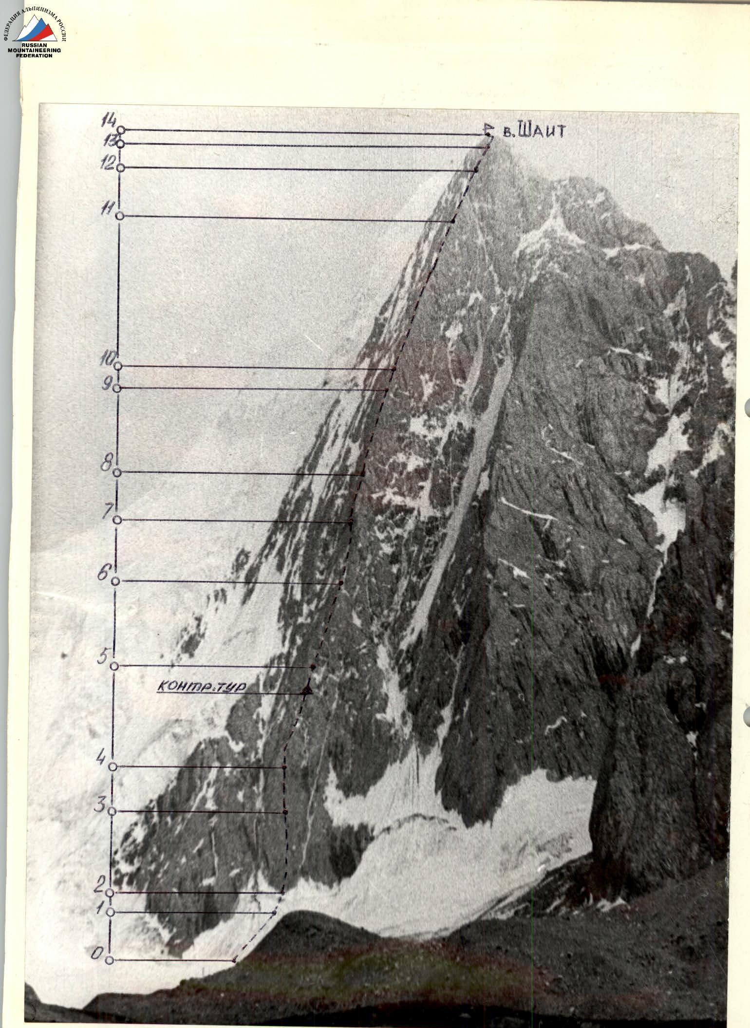
- Peak, its height, ascent route: Shait, 4916 m, via N.N.E. wall by Ovcharov's path.
- Proposed difficulty category: 5B
- Route characteristics: height difference — 900 m; average steepness — 65°; length of sections: 1st diff. cat. — 40 m, 3rd-4th diff. cat. — 510 m, 5th diff. cat. — 400 m, 6th diff. cat./technical — 50 m.
- Pitons hammered: for belaying: rock — 19; ice — 5; protection gear — 98. for creating belay stations: rock — none; ice — none; protection gear — 5.
- Number of climbing hours: 20 hours.
- Number of nights and their characteristics: 1, platform on the ridge between Shait and Bursun peaks.
- Full name of the leader, participants; their sports qualification: Pershin Valery Nikolaevich — Candidate Master of Sports, leader; Yakovlev Vitaly Dmitrievich — Master of Sports of the USSR, participant; Kurьян Arut Arutovich — 1st sports category, participant.
- Team coach: Yakovlev Vitaly Dmitrievich.
- Date of departure and return: departure — July 9, 1980, 3 hours; return — July 10, 1980, 10 hours.

TABLE OF MAIN ROUTE CHARACTERISTICS

 www.alpfederation.ru↗
TABLE OF MAIN ROUTE CHARACTERISTICS
www.alpfederation.ru↗
TABLE OF MAIN ROUTE CHARACTERISTICS
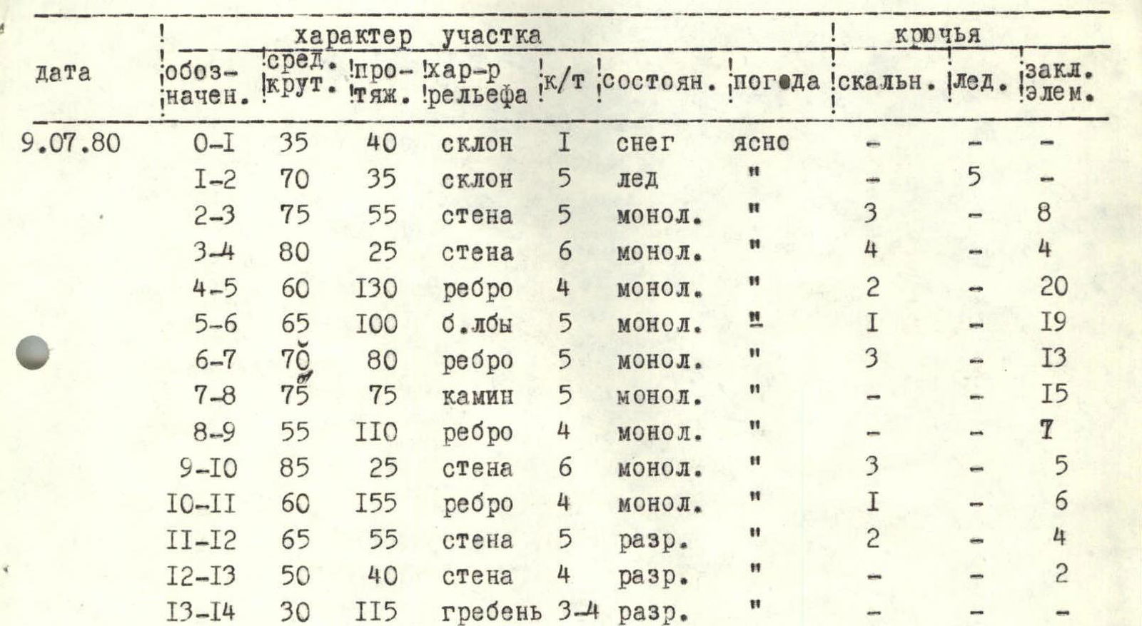
| Date | Section | Steepness | Difficulty | Terrain | Diff. cat. | Condition | Weather | Rock | Ice | Protection gear |
|---|---|---|---|---|---|---|---|---|---|---|
| July 9, 1980 | 0–1 | 35 | 40 | slope | 1 | snow | clear | – | – | – |
| 1–2 | 70 | 35 | slope | 5 | ice | " | – | 5 | – | |
| 2–3 | 75 | 55 | wall | 5 | monolith | " | 3 | – | 8 | |
| 3–4 | 80 | 25 | wall | 6 | monolith | " | 4 | – | 4 | |
| 4–5 | 60 | 130 | ridge | 4 | monolith | " | 2 | – | 20 | |
| 5–6 | 65 | 100 | "ram's foreheads" | 5 | monolith | " | 1 | – | 19 | |
| 6–7 | 70 | 80 | ridge | 5 | monolith | " | 3 | – | 13 | |
| 7–8 | 75 | 75 | chimney | 5 | monolith | " | – | – | 15 | |
| 8–9 | 55 | 110 | ridge | 4 | monolith | " | – | – | 7 | |
| 9–10 | 85 | 25 | wall | 6 | monolith | " | 3 | – | 5 | |
| 10–11 | 60 | 155 | ridge | 4 | monolith | " | 1 | – | 6 | |
| 11–12 | 65 | 55 | wall | 5 | destroyed | " | 2 | – | 4 | |
| 12–13 | 50 | 40 | wall | 4 | destroyed | " | – | – | 2 | |
| 13–14 | 30 | 115 | ridge | 3–4 | destroyed | " | – | – | – |
Brief explanation of the table
0–1 Dense firn. 1–2 Ice slope with a bergschrund. Bergschrund is crossed via a bridge. 2–3 Wall. Movement straight up. 3–4 Steep wall, passed in the direction of the ridge. 4–5 Ridge, mostly traversed on friction. 5–6 Rocks like "ram's foreheads", passed on the left part of the ridge. 6–7 Ridge like a bastion, passed in the center. Climbing is difficult, few holds. 7–8 Chimney with a plug in the lower part. 8–9 Ridge with walls 5–7 m high, small ledges present. 9–10 Smooth wall with small holds. 10–11 Ridge passed on the right. 11–12 Wall, ledges present, rock is unreliable. 12–13 Wall. Rock is unreliable. 13–14 Pre-summit ridge.