
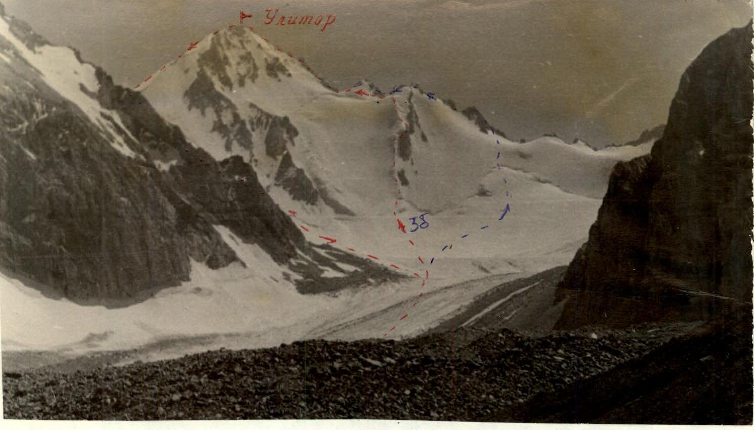
Description of the ascent route to the summit Ulitor 4680 m via North spur of West ridge, category 3B difficulty (orientation)
The summit Ulitor 4680 m is located in the spurs of the Alay ridge in the Kollektorskiy range between the summits Fergana and Zachetnaya. To the east of Ulitor lies the pass Fergana, category 1B difficulty, and to the west - the pass Ulitor, category 2B difficulty.
To approach the start of the route from the alplager "Dugoba", it is necessary to:
- ascend along the Dugoba gorge (via a trail) to the confluence with the Ulitor river,
- then along the Ulitor river gorge (via a trail) to the 3600 m campsite.
From there, continue up the gorge (keeping to the right-hand side):
- initially via a trail,
- then across moraines,
- emerging onto the Ulitor glacier and traversing its center towards the summit Ulitor.
The journey from the alplager to the 3600 m campsite takes 4-5 hours, and from the 3600 m campsite to the start of the route - 2.0-2.5 hours.
The route passes along an icy spur, to the right of which lie three small rocky outcrops with heavily fractured rocks, the lower parts of which are sheer.
From the glacier to the start of the spur, the ascent is via firm firn (snow at the beginning of the season) with a slope of 30-35° and a length of 150-180 m.
At the start of the spur, a bergschrund is overcome via bridges.
Further movement:
- Along the icy ridge with a slope of 45-50°, using alternate protection via ice screws (9 screws driven).
- After 3 rope lengths (120 m), an exit onto rocks is possible.
- The rocks are of medium difficulty, with a slope of 60°, heavily fractured.
- Movement across them is with alternate protection via protrusions; using ice screws is possible (2 ice screws driven into rocks).
- Continuing along the icy ridge is also possible, with a slope reaching 55-60°.
After one rope length, the rocky spur merges with the icy one. A control cairn is located at this point.
From the control cairn:
- Two rope lengths across rocks (2 ice and 2 rock screws).
- Then an exit onto ice with a slope of 45-50°, the length of the section being 100-120 m (7 ice screws driven).
Then:
- An exit onto a gradually flattening snowfield.
- Further onto the ridge beneath the "gendarme".
The "gendarme" is traversed along a snow-ice slope with an exit onto rocks, the average slope being 40-45°, protection via ice screws (3 screws).
Then:
- 10 m across rocks, protection via rock screws (2 pieces).
- Descent to a saddle via snow - 30 m.
Further rocky outcrops lead onto a ridge with a slope of 35°, leading to the summit. Protection via rock protrusions.
The path from the "gendarme" to the summit coincides with the classified route to the summit from pass Ulitor, category 3B difficulty.
Descent from the summit is via the category 2B difficulty route through pass Fergana:
- Initially along a scree ridge.
- Then from the pass along a snow-ice slope onto the Ulitor glacier.
The first ascent of the route was made on August 15, 1969, by a group of climbers led by instructor KMS Slabtsov V.E.
After the first ascent, the route was traversed by another group.
The route to the summit Ulitor via the North spur of the West ridge is more challenging than the route from pass Ulitor.
The significant value of the route lies in its snow-ice nature, as there are almost no ice and snow-ice routes in the nearby areas of alplager "Dugoba".
Comments
Sign in to leave a comment