
Ascent Passport
- Ascent category: technical
- Ascent region: Pamir-Alay, Alay Ridge
- Ascent route: Peak Uzbekistan 5140 m (via the ice board of the northern wall)
- Route characteristics height difference: 1050 m, average steepness: 65°, most challenging sections: 90°
- Length of sections: III cat. diff. — 420 m, IV cat. diff. — 160 m V cat. diff. — 535 m, VI cat. diff. — 120 m
- Pitons used: for belaying: rock 44, ice 43 for creating ITO: rock 4, ice — bolted: — Number of placed protection: 40
- Total climbing hours: 21 h
- Number of bivouacs and their characteristics: one bivouac, sitting.
- Surname, name, patronymic of the leader and participants, their sports qualification:
- Samoylin Mikhail Alekseyevich, MS
- Lebedikhin Alexey Veniaminovich, MS
- Vinogradsky Evgeny Mikhailovich, MS
- Abramov Sergey Semenovich, CMS
- Team coach — Lebedikhin Alexey Veniaminovich
- Date of departure and return: from July 21 to July 24, 1978
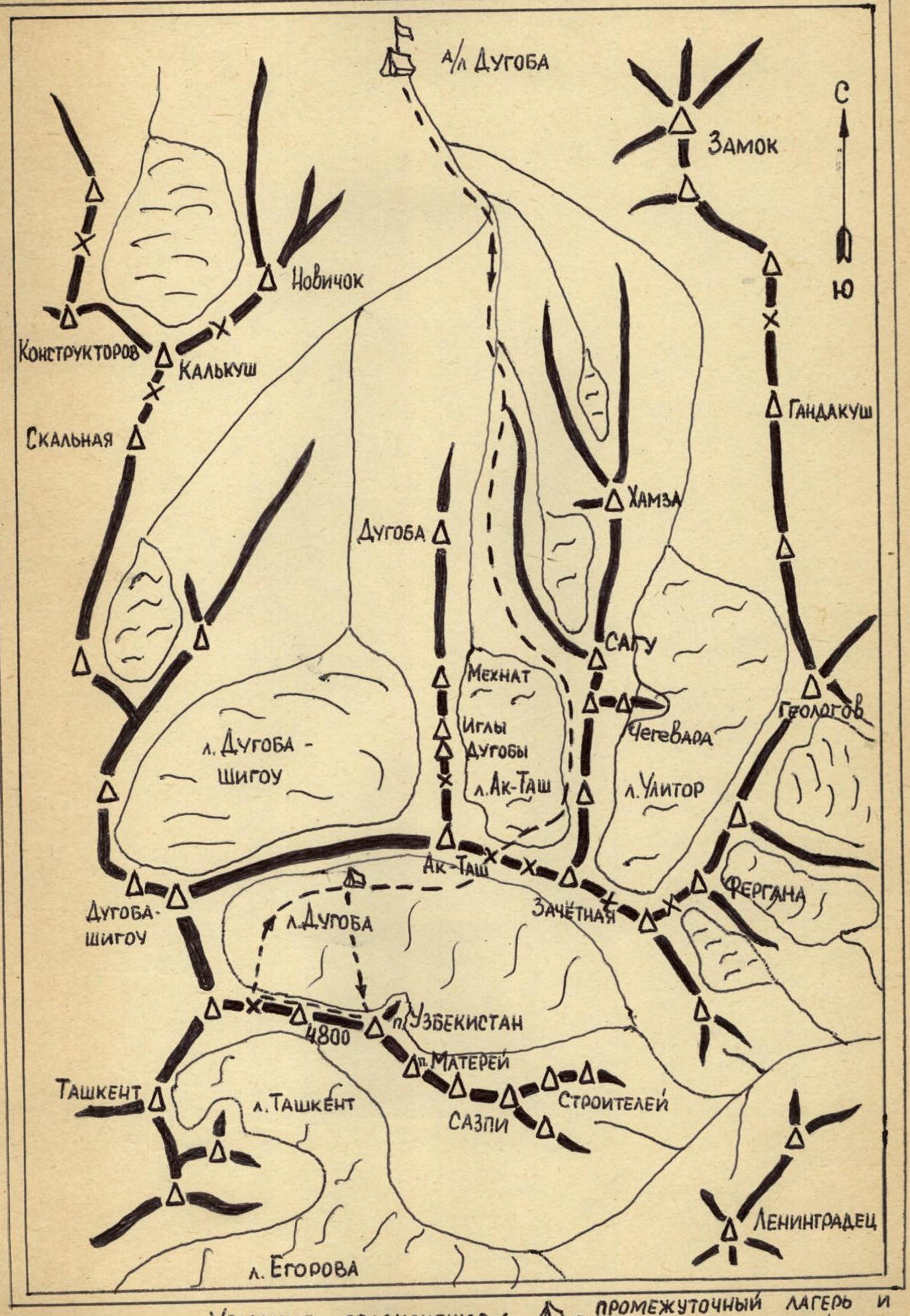
Map of the Ascent Region
Route Profile to Peak Uzbekistan via the Ice Board of the Northern Wall

Brief Geographical Description and Sporting Characteristics of the Ascent Object
Peak Uzbekistan (5140 m) stands out due to its unusual shape, resembling an elephant, located in a spur of the Alay Ridge (Pamir-Alay, area of the "Dugoba" alpine camp) and is adjacent to:
- to the southeast — Peak Materiy,
- to the west — Peak 4800 m.
The spur where the peak is located separates the glaciers:
- Dugoba (to the north),
- Egorov (to the south).
A small glacier Tashkent also adjoins the spur from the south.
Peak Uzbekistan is the highest point of the spur. Several routes of 5B–6B cat. diff. have been laid to the summit.
Thus, in 1961:
- A team of two masters of sports of the USSR from Tashkent — G. Ovcharov and V. Elchibekov — ascended the steep, purely rocky northeastern wall.
In September 1976, a team from the Sports Committee of the UzSSR climbed to the summit via the right buttress of the northern wall in 5 days, taking first place in the republic's championship.
In August 1977, a team from the Dugoba alpine camp, participating in the USSR championship, climbed to the summit via the central buttress of the northern wall in 4 days.
To the left of the central buttress, a section of the northern wall is a very steep (55–60°) ice board, topped with a sheer rocky bastion. The ascent route via the ice board, the bastion, and further along the buttress to the summit presented a rather complex but very interesting mountaineering challenge, was extremely logical, and sufficiently safe…
After thoroughly discussing these qualities of the route and weighing our capabilities, our team chose it as the main option for participating in the 1978 "Burevestnik" Central Council alpine climbing championship.
Climbing Conditions in the "Dugoba" Alpine Camp Area
The approaches to Peak Uzbekistan do not present technical difficulties. The path to the Ak-Tash pass from the camp follows a trail along the mountain rivers Dugoba and Ak-Tash and takes 7–8 hours, then another 1.5 hours to the assault camp on the orographic left moraine of the Dugoba glacier. The approach path was well-studied by the ascent participants during the preparatory period — during their internship and work at the Dugoba alpine camp.
Climatic conditions for ascents in this area are usually favorable. The area is warm. The weather is generally quite stable, with many sunny days; precipitation in the form of snow (at Ak-Tash bivouacs and above) and rain usually occurs 1–3 times during the camp's operational period.
Peak Uzbekistan has another peculiarity — it is composed of completely different rock types, alternating in the form of black "belts," with all black belts being strongly weathered granite rocks, and the yellow belts also differing from each other.
- The first yellow belt (rocky bastion) is a fairly strong and monolithic marbleized limestone.
- The next yellow belt and above are composed of related rocks but have a very "unpleasant" structure — as if made of compressed crumbs.
The vast majority of routes to the peaks of the Alay Ridge are purely rocky. The route along the northern wall of Peak Uzbekistan chosen by our team attracted our attention also because it represented a combination of a fairly extensive (400–500 m) and very steep (60°) ice wall and a sheer rocky bastion, leading directly to the summit. The choice of this route was obviously predetermined to some extent also by the fact that the team already had experience climbing three routes similar in character: Peak Free Korea — 6B cat. diff., Peak Pravda — 5B–6A cat. diff., and Peak Russia — 6B cat. diff.
Organizational and Tactical Plans
The choice of the object for the ascent within the framework of the "Burevestnik" Central Council Championship was largely conditioned by the fact that our team had climbed a very serious ice-rock route on Peak Russia in the summer of 1977 and had greatly enjoyed it.
The route via the ice board of the northern wall of Peak Uzbekistan, with its steepness and overall character, closely resembles our previous year's route, albeit on a smaller scale.
We decided to retain the same team work scheme on the route, developed over the years and proven effective on complex ascents. The scheme involves fixing ropes in advance and passing through sections of any difficulty, up to the most complex ones, with backpacks, which:
- significantly accelerates the group's progress as a whole,
- reduces the time spent at altitude,
- and thus increases the reliability of completing the ascent.
The quick and clear passage of the wall once again confirmed the correctness of the chosen tactics.
Route Description
July 22. We leave the intermediate camp at 5:15 and, after 30 minutes, crossing the Dugoba glacier, approach the route. We once again examine the lower part of our chosen route, plan the most optimal options for overcoming the bergschrund, link up, and begin the ascent at 6:15.
The beginning of the route (sect. R1) is a firn slope of average steepness (photo 1). We move simultaneously. After overcoming the bergschrund via a snow plug and a small ice wall, we then move left upwards by 20 m and reach the start of a smooth, steeply ascending ice board (sect. R2). The average steepness is 60°. We follow our planned path through the center between two clearly defined gullies (photo 1).
Lebedikhin and Samoylin work first. We move evenly and practically without delay. Thorough piton belaying! The experience of climbing the 1300-meter ice wall of Peak Russia last year is evident (photos 2, 3, 4).
After bypassing a rocky outcrop on the left, we gather together under a steep, yellow, fairly monolithic rocky bastion for a short rest and snack. Time is 11:00.
The ascent on the rocks begins with overcoming a sheer wall (sect. R3). Climbing is extremely difficult.
We then carefully climb to the right along the sheer wall. The rocks, covered in ice, have a well-defined structure but are fairly strong. We use protection (sect. R3, photo 5). Climbing is challenging.
We then traverse along the wall to the left for 10 m and then upwards to the right along a sheer wall, reaching black rocks clearly forming a "T" shape (sect. R4, photo 1).
We move along the black rocks to the right and upwards for 15 m. On a small shoulder — a control cairn. After climbing another 30 m along black, heavily weathered rocks, we approach a sheer monolithic yellow wall and, on a small ledge, organize a bivouac site. Time is 17:45.
While the bivouac site is being set up for a sitting bivouac, Lebedikhin and Vinogradsky processed the next two sections of extremely difficult climbing:
- steep "sheep's foreheads"
- a sheer monolithic wall with very few holds (sect. R6–R7, photo 6)
The galoshes we brought for this occasion were very helpful.
July 23. We climb along the pre-fixed ropes on sections R6 and R7 and then again along black, heavily weathered rocks in the form of a vaguely defined ridge (sect. R8) to the next light belt of rocks composed of marbleized limestone, often representing compressed "crumbs" (sect. R9).
We continue along an ice ridge abutting a rocky tower of the main ridge of Peak Uzbekistan (sect. R10).
We bypass the rocky tower by traversing to the right and upwards along weathered rocks and reach an ice-rock ridge leading to the summit. Time: 16:15. The descent route goes along the ridge via Peak 4800 m and a saddle under Peak Tashkent to the Dugoba glacier.
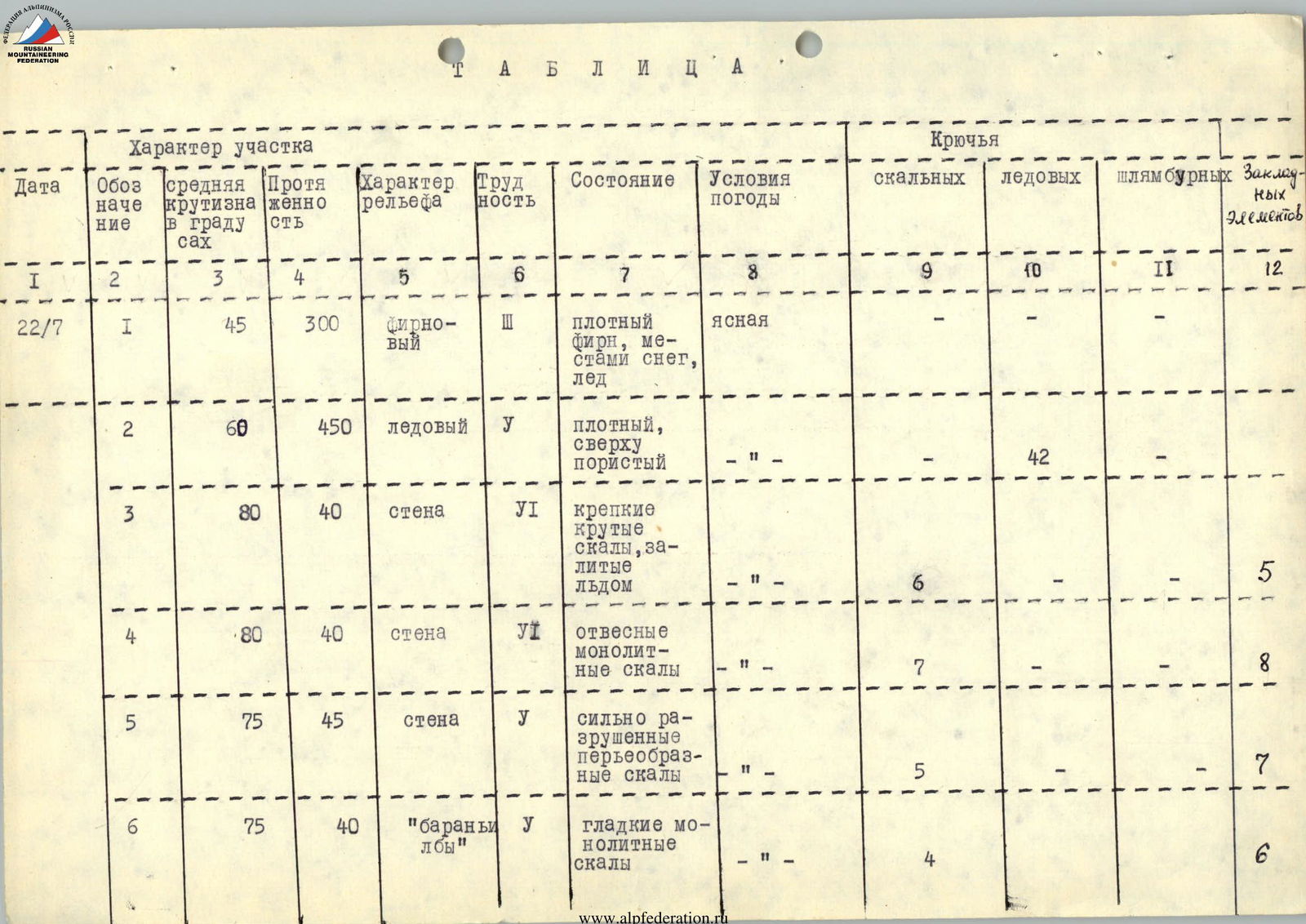
| Date | Designation | Average Steepness in Degrees | Length | Terrain Character | Difficulty | Condition | Weather Conditions | Rock Pitons | Ice Pitons | Bolts | Protection |
|---|---|---|---|---|---|---|---|---|---|---|---|
| 22.07 | R1 | 45 | 300 | firn | III | dense firn, snow, ice in places | clear | — | — | — | — |
| R2 | 60 | 450 | ice | V | dense, porous at the top | clear | — | 42 | — | — | |
| R3 | 80 | 40 | wall | VI | strong, steep rocks, covered in ice | clear | 6 | — | — | 5 | |
| R4 | 80 | 40 | wall | V | sheer monolithic rocks | clear | 7 | — | — | 8 | |
| R5 | 75 | 45 | wall | V | heavily weathered, feather-like rocks | clear | 5 | — | — | 7 | |
| R6 | 75 | 40 | "sheep's foreheads" | V | smooth monolithic rocks | clear | 4 | — | — | 6 | |
| 23.07 | R7 | 90 | 40 | "sheep's foreheads" | VI | smooth monolithic rocks | clear | 4 | — | — | 7 |
| R8 | 50 | 80 | vaguely defined ridge | IV | heavily weathered rocks | cloudy | 10 | — | — | 6 | |
| R9 | 70 | 40 | same | IV | weathered rocks with soft rock | cloudy | 5 | — | — | 5 | |
| R10 | 50 | 40 | ice | III | exposed ice | heavy cloudiness | — | 1 | — | — | |
| R11 | 60 | 80 | tower | IV | weathered rocks | cloudy | 4 | — | — | 2 | |
| R12 | 40 | 80 | pre-summit ridge | III | exposed ice, weathered rocks | cloudy | — | — | — | — |

Departure time — 6:15; stop time — 17:45. Climbing hours — 11, sitting bivouac in a tent. Departure time — 7:30, climbing hours — 10.
Photo 1. General view of the northern wall of Peak Uzbekistan in the area of the climbed route.
Photo 2. Profile of the northern wall of Peak Uzbekistan in the area of the climbed route.
Comments
Sign in to leave a comment