I. Class of technically difficult ascents.
2. Pamir-Alay. Alay ridge. Arch-Kanysh gorge.
3. Peak Sovetskikh Shkolnikov (4850 m) via the center of the Eastern wall.
4. 5B category of complexity.
5. Characteristics of the route:
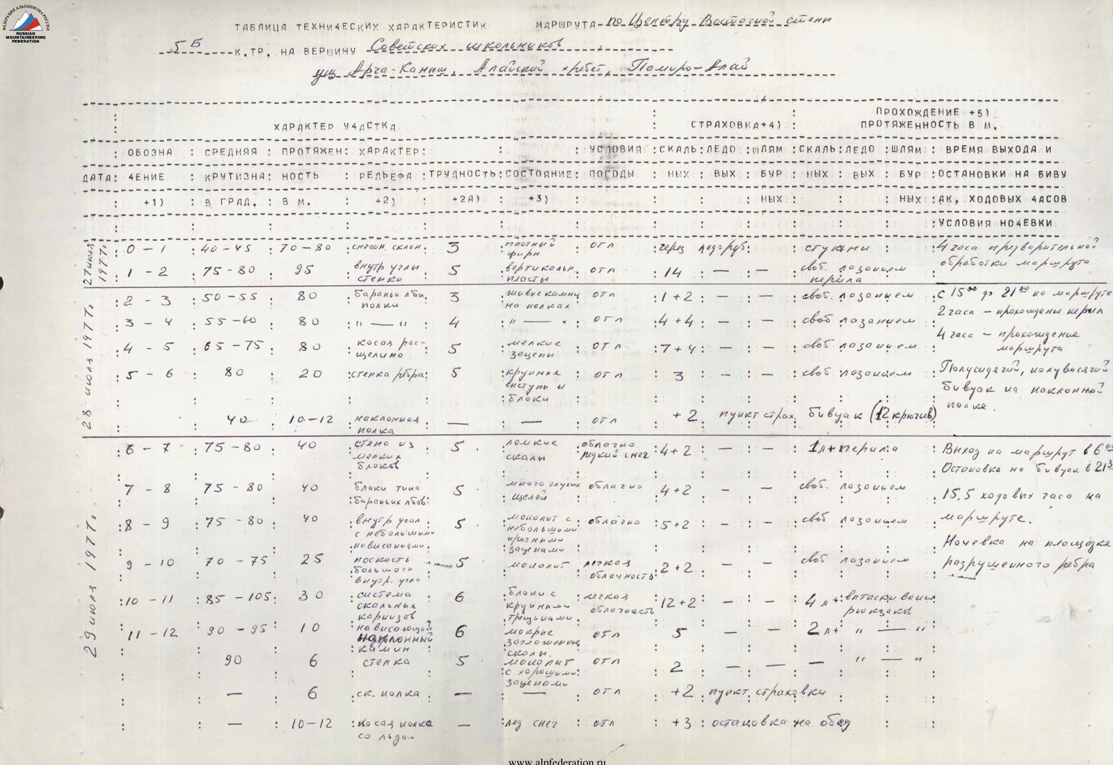
a) height difference — 750 m,
b) length of sections with 5–6 category difficulty — 506 m,
c) average steepness — 75–80°.
6. Number of pitons hammered:
a) rock pitons — 109,
b) ice pitons — 0,
c) bolt pitons — 0.
7. Total hours on the route — 25.75 hours.
8. Two nights on the route. One bivouac was sitting, and the other was in a tent on a convenient platform.
9. Leader of the ascent — Petrichenko N.N., Candidate Master of Sports in mountaineering and rock climbing.
* Kozyrin V.K., 1st category in mountaineering and rock climbing.
* Protsenko L.V., Candidate Master of Sports in mountaineering.
* Rybalka K.P., 1st category in mountaineering and rock climbing.
10. Team coach — instructor Petrichenko N.N.
11. Date of departure to the route — July 28, 1977, date of return from the route — July 30, 1977.

Eastern wall according to Soviet Rules. Alay ridge, Arch-Kanysh gorge.
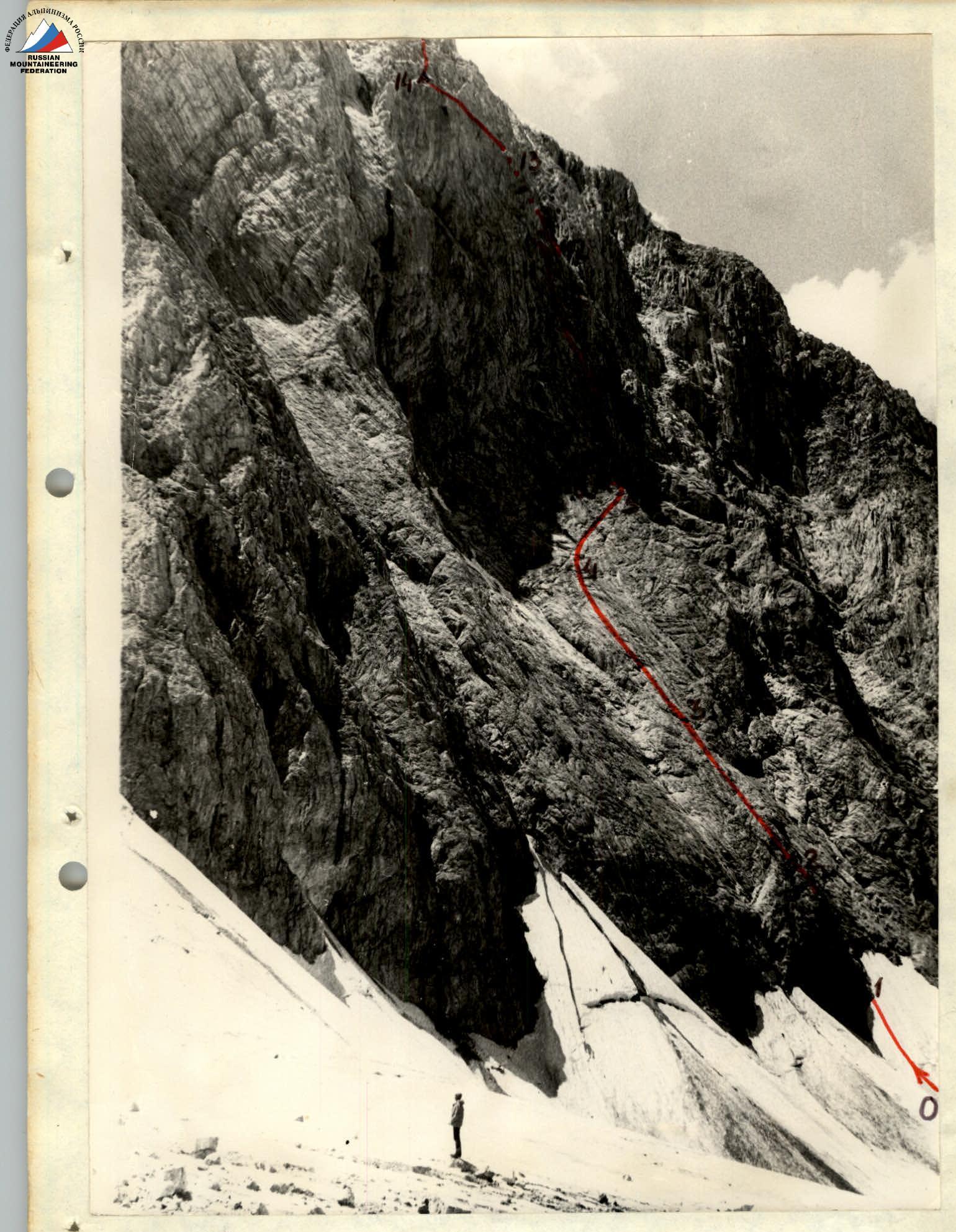
Progress along the eastern wall.
Geographical location and sporting characteristics of the peak
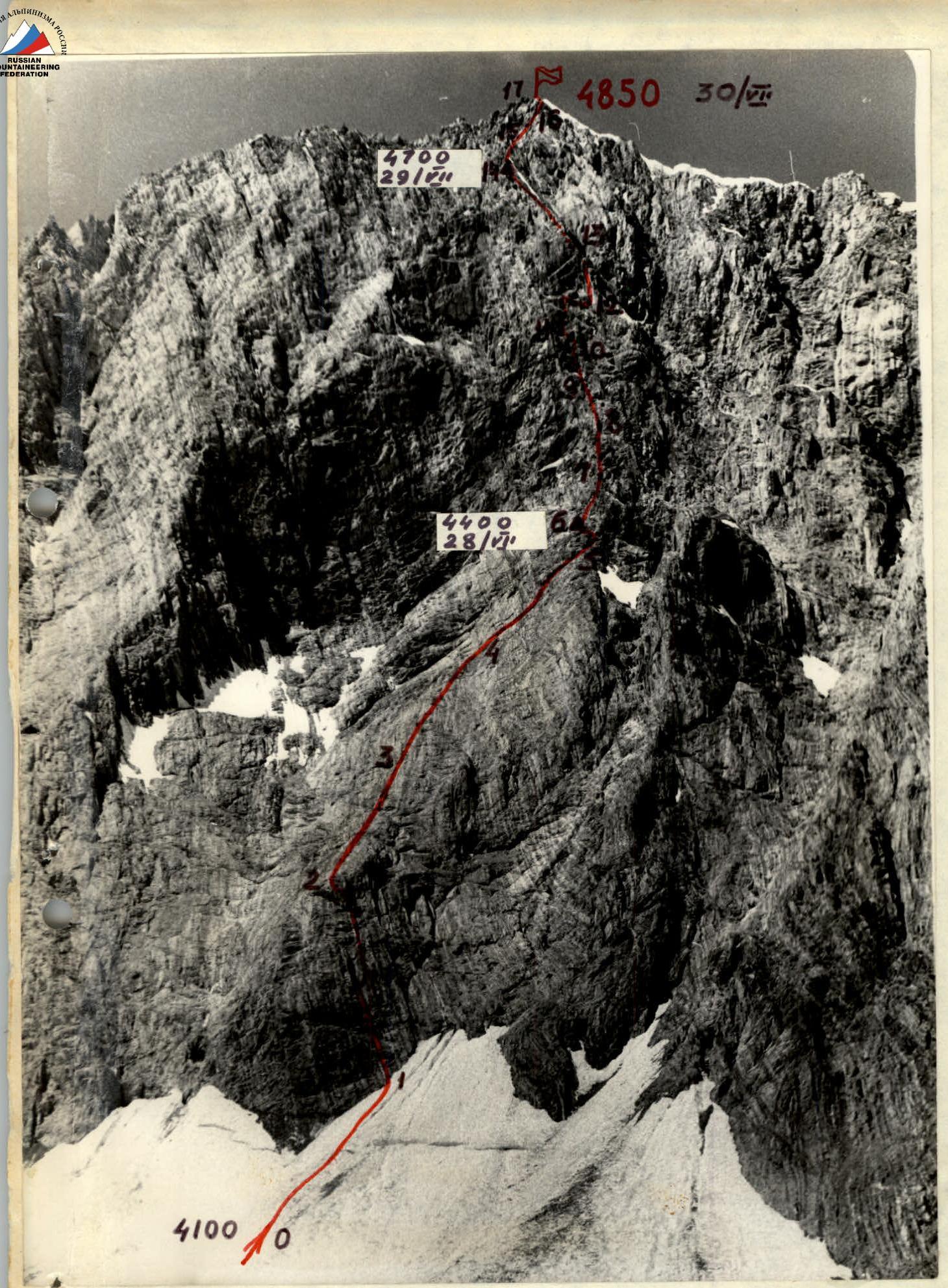
Peak Sovetskikh Shkolnikov (4850 m) is located in the Arch-Kanysh gorge in Pamir-Alay. The remoteness of the area from mountaineering bases (a day's journey from the nearest Dugoba tourist center via Ak-Tash pass) and significant difficulties with organizing a base camp complicate the development of this very promising mountaineering area. The area remains understudied, although recently there have been mountaineering camps for Uzbekistan and Leningrad athletes.
The peak Sovetskikh Shkolnikov drops to the northeast with a sheer rock wall with a height difference of about 800 m. The southern slopes of the peak are dissected by steep scree gullies, typical for the southern slopes of most Pamir-Alay peaks. From the northwest, the peak has a snow and ice slope with a steepness of 50–55°, cut by icefalls.
Until recently, there was only one mountaineering route to the peak — the path of Shumilov's group, category 4B, along the northeastern ridge. In the 1977 season, a group of Dnipropetrovsk mountaineers ascended Peak Sovetskikh Shkolnikov via the most steep and complex central part of the Eastern wall. This route, in terms of its length and technical characteristics, is rightfully classified as category 5B. However, this route does not exhaust all the sporting possibilities of the Eastern wall. To the left of the passed route, there is another very logical path to the peak, which is no less complex.
The Eastern wall is composed of massive and marbleized limestones. The holds are generally solid, and the rocks are pleasant to work on in rubber boots.
One of the factors complicating the ascent up the Eastern wall is the limited possibilities for obtaining water on the route. For almost 2/3 of the route, the group cannot find water, as the available snowfields are in extremely stone-dangerous gullies.
The second complicating factor is rockfall. The fact is that the Eastern wall is dissected from bottom to top by several almost sheer gullies. Therefore, during rockfalls originating near the summit, stones easily scatter beyond the gullies and can hit almost the entire lower part of the wall.
Reconnaissance of the route
From the base camp of the Dnipropetrovsk mountaineering gathering, located at the confluence of the Dugoba and Arch-Kanysh rivers, the Eastern wall of Peak Sovetskikh Shkolnikov is almost fully visible. However, the group observed the wall for quite a long time before deciding to lay a route and begin thorough preparation for the ascent.
Observing the wall for two days showed that the proposed path is category 5B. During this time, the rockfall regime was studied. With different lighting, individual sections of the route were examined using a 20x telescope. The reconnaissance established that after 14:00, when the sun leaves the wall, rockfalls almost completely cease.
As a result of the wall reconnaissance, studying the rockfall regime, and testing the route by passing the lower part of the wall with 100 m of fixed ropes, the following ascent tactics were developed:
- a) Departure on the route at 15:00, passing previously fixed ropes and advancing another 6–7 ropes to the "red rocks" to the bivouac site. An earlier departure was ruled out as it did not ensure the necessary time reserve for passing the unprotected section of the wall, 4–5 ropes long, where there was a high risk of being hit by stones that, when falling from a great height, often went beyond the gullies and scattered widely across the wall.
- b) On the second day, it was planned to pass the most complex part of the route along the red rocks, bypassing the "mirror." The second night's bivouac was planned near a small snowfield on the pre-summit ridge.
- c) On the third day, it was planned to reach the summit, descend, and return to the base camp via the Sovetskikh Shkolnikov pass.
- d) A reserve day for bad weather and unforeseen difficulties.
The planned tactical plan was fully executed; however, its execution required working for 15.5–16 hours on the second day. The reserve day was not used.
Equipment and supplies. The group was provided with food for 3⅔ days. The total weight of food products was 10 kg. Canned and dried products — sausage, lard, smoked fish, canned chicken, and goose liver — formed the basis of the diet. Honey and currants were the basis for desserts. On bivouacs, the group prepared only tea, which allowed them to save weight on fuel and time on cooking.
The group used mainly standard equipment on the route. Two participants wore "Vibram" boots, and two wore "Trikoni" boots with galoshes. Communication with the observation group was maintained using a "Vitalka" radio station. The total weight of the backpack during movement along the route did not exceed 12 kg. The main equipment of the group is given in the table:
| Item | Quantity | Used | Total weight |
|---|---|---|---|
| Main rope | 3 × 40 m | Constantly | 7.0 |
| Rock pitons (VTSSPS) | 15 | «—» | 1.5 |
| Titanium rock pitons | 10 | «—» | 0.6 |
| Ice pitons (VTSSPS) | 4 | «—» | 0.6 |
| Titanium wedges | 6 | «—» | 0.4 |
| Bolt pitons | 10 | Not used | 0.2 |
| Drill bits | 2 | «—» | 0.2 |
| Ice screws | 4 | On descent | 0.25 |
| Crampons | 2 | «—» | 2.0 |
| "Pamirka" tent | 1 | On bivouac | 3.0 |
| Stove with fuel | 1 | «—» | 2.0 |
| 3-step ladders | 3 | Sections 10, 11 | 1.0 |
| Hammers | 2 | Constantly | 1.5 |
| Clamps | 3 | Sections 2, 6–12 | 0.4 |
| Safety harness with sling | 4 | Constantly | 2.0 |
| Disposable cordelette | 20 m | On descent |
Order of passage on the route
July 26 — observation of the route.
July 27 — observation of the route and passage of a 100-meter section of the wall with fixed ropes.
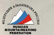
July 28 — Day one. At 11:00, the group left the bivouac at the confluence of the Dugoba and Arch-Kanysh rivers, crossed the Dugoba river, and then the Arch-Kanysh river, and approached the moraine of the glacier under the Eastern wall at 13:00. There were still two hours before departing on the route. Using this time, we listened to the wall and once again made sure that it was gradually calming down. At 15:00, exactly as planned, we took our prepared backpacks and moved under the wall of the bastion, where about 100 m of ropes had been fixed since yesterday.
The route begins on a snow cone with increasing steepness. The last 70–80 meters on dense snow are traversed in three pitches (almost nothing remained of yesterday's steps). Without stopping, we move to the fixed ropes. Yesterday, during route preparation, 8 re-belay points were made on the fixed ropes, thanks to which all participants cross onto the rocks in 15–20 minutes and do not delay the movement.
The fixed ropes are tensioned on the bastion wall with a steepness of 75–80°. To the left, the wall is even steeper. To the right, 7–10 m from the ropes, the rocks are somewhat gentler, but numerous marks from stone impacts in this area suggest that the ropes are fixed in the optimal zone in terms of difficulty and safety.
Our backpacks are not too heavy — only 10–12 kg, but it takes 2 hours for the first rope team, Petrichenko—Protsenko, to start moving along the unprocessed path. The second rope team dismantles the fixed ropes and drops the fourth extra rope down to the glacier.
Further on, the path seems relatively simple. Indeed, the first rope length is passed easily — only one piton is needed for belay. Then the rocks become steeper and smoother. The average steepness is no more than 50–55°, but "ram's foreheads" with short, smoothed walls and small ledges, abundantly covered with fine gravel, are constantly encountered. There is a constant need to hammer in pitons, but they go in poorly into the smoothed limestone.
The rope teams move independently to the right and upwards towards the red rocks, where the first bivouac is planned. The route becomes steeper. To the right and upwards, under the red ridge, there is a gully or internal angle formed by a sheer upper edge and a 70-degree lower edge — a logical continuation of the path. It is quite difficult to ascend, although not to the limit. Only sometimes do toes go numb in galoshes or a knee tremble from static load. For hands, it's good, despite the fact that the holds are not large — with a sense of security, small sharp needles of familiar "Crimean" limestone dig into the fingertips. The gully—internal angle gradually dissolves into a system of small sheer walls and small disordered ledges. On average, the steepness is not great — no more than 65–70°. In search of the optimal path, we "embroider" the wall in the direction of the red ridge.
Finally, we approach the ridge. Somewhere here, a ledge for the night and a snowfield for drinking were visible. We pass another 20–25 m along the ridge. To the left, we find a large ledge, but:
- its slope is 40–45°;
- there is no building material;
- there is no hope for a decent bivouac.
A snowfield is also visible in a huge gully, but:
- it is in a rather dangerous zone;
- the approach to it is not pleasant.
Nevertheless, it's already 21:00, and it's time to set up a bivouac. According to arrangements with the base, we establish radio contact. From below, they report that the group is clearly visible through the telescope, and the base altimeter has recorded 30 m of ascent, warning of deteriorating weather.
While Vitya Kozyrin and Kostya Rybalka are busy with the bivouac, we manage to process 40 m of the route for tomorrow.
The bivouac in a niche under an overhanging rock more resembles a hammock woven from two forty-meter ropes than a place for the night. Here, half-sitting on backpacks, half-hanging on ropes and harnesses, we spend the first night on the route.
July 29 — Day two. At night, snow grains occasionally fell, but the night passed tolerably. At 6:00, leaving a note in a can on a piton, we leave the hospitable "hammock" in the niche and head out on the route.
Here it turns out that:
- the first 3–4 m of fixed ropes slightly overhang and are not passable with a backpack;
- yesterday, without a backpack and in galoshes, this piece somehow didn't stick in our memory.
We have to use a ladder. Further on, the path goes through a labyrinth of internal angles, piled-up small walls among overhanging blocks. There are no good landmarks. We pass 3.5 rope lengths to the left and upwards in the direction of the intended route.
< The sky is covered with clouds, not letting in the sun's rays. With only one flask of water left, we would have suffered from thirst under the scorching Pamir sun.
Ahead appears a series of overhanging blocks with well-developed microrelief. To the left and right — mirror-smooth sheer drops. The first attempts to pass the section using free climbing showed the futility of this endeavor.
The section was passed using the following means:
- more than 10 short pitons;
- étrier;
- hanging on a shortened self-belay;
- four ladders.
Using these means, we managed to break through the series of overhanging blocks in three hours of work. Then a rope is thrown down, the guys remove the lower ladder, and using the harness-ladder method with the help of a clamp and "Bachmann," they overcome the cornice. Backpacks are pulled up.
Further on, the path goes through an 8-meter black chimney with wet walls and a 6-meter sheer wall with good, solid holds. In the chimney, there is an overhanging section that deflects to the right. Two ladders are needed to pass it. Again, we have to pull up the backpacks.
Traversing along a ledge to the right, we approach a small snowfield located on a wide, sloping ledge. Here we decide to stop and have a snack. For 40 minutes, we melt ice and drink warm, muddy water with pleasure.
From the snowfield, we continue along a steep ridge of gray, large-block granite. After 40 m, the ridge becomes more destroyed, and gullies appear with many small "live" stones. The holds are brittle, the cracks are clogged with sand — a result of the weathering of marbleized limestones further along the route.
- It is very difficult to organize reliable belay;
- Extreme attentiveness and caution are required due to frequent stone dislodgments caused by the rope.
For the first time, a safe platform for a tent is encountered, but without water. We decide to process another two rope lengths and, if there is no prospect of a more convenient bivouac, to stop here.
Further on, the rocks become completely destroyed, as they consist of sandy rocks. Gradually, the slope eases, ledges appear, and approaching the snowfield, we begin constructing a platform for the tent at 21:30.
The establishment of good weather and moonlight contributed to extending the working day.
Using all the advantages of a convenient bivouac, the group lazily had dinner, enjoying an abundance of tea until 2:00 AM.
July 30 — Day three. The remaining section of the route did not present particular technical difficulties. Having rested well, the group started moving along the route at 9:15 and reached the summit at 11:30.
The descent from the summit was carried out along the scree and gullies of the southern slope and further through the Sovetskikh Shkolnikov pass under the Eastern wall onto the glacier.
The descent took approximately 5 hours, and at 18:00, the group returned to the base camp.
Conclusion
The route of ascent to Peak Sovetskikh Shkolnikov via the center of the Eastern wall is a complex and interesting mountaineering route that requires climbers to have high technical skill and tactical maturity.
In terms of relief character and technical characteristics, the wall is very reminiscent of the northeastern wall of Peak Uzbekistan, and the route itself is similar to the well-known route by G. Ovcharov on Peak Uzbekistan, rightfully considered a benchmark for category 5B routes in the Dugoba tourist center area.
In terms of technical characteristics, the passed route is more complex than most known category 5B routes known to the group, such as:
- SAGU via the pillar,
- Chapdara via the northern ridge,
- Dalar via the northeastern ridge,
- Uzbekistan via V. Rossoha's path,
- Uilpata via the central counterfort, but somewhat weaker than B. Korablin's route on Dalar via the northeastern wall.
The group spent 26 hours on processing the wall and passing the route. To ensure movement and belay on the route, more than 100 rock pitons were hammered, and ladders were used in seven instances. The route was passed without using bolt equipment.
The group believes that the route via the center of the Eastern wall on Peak Sovetskikh Shkolnikov should be classified as category 5B and recommends this route as a qualifying route in the Arch-Kanysh gorge area.
Leader of the ascent, team captain (N. Petrichenko)