Ascent Passport
- Ascent class: technical
- Ascent area: Pamir-Alay, Alay ridge
- Ascent route: SAGU, 4650 m, via the "per'ya" of the North ridge
- Proposed difficulty category: 5B
- Route characteristics: height difference 1050 m, length of sections with 5–6 difficulty category 720 m, average steepness 68° (up to the ridge)
- Pitons driven:
for belaying, for creating I.T.O.:
- rock 108
- ice 5
- bolt 0
- protection gear 27
- 12
- Number of climbing hours: 35 h
- Number of nights and their characteristics: two — one hanging and one lying down
- Surname, name, patronymic of the leader, participants, and their qualification: Semenyuk Valery Danilovich CMS Antipin Sergey Mikhailovich CMS Bryksin Valery Mikhailovich CMS Sereda Vladimir Alexandrovich CMS Svítov Anatoly Mikhailovich CMS Kurmachev Yuri Fedorovich CMS
- Team coach: Yakovlev Vitaly Dmitrievich, Master of Sports of the USSR
- Date of departure and return: departure: June 27, 1978 return: June 30, 1978
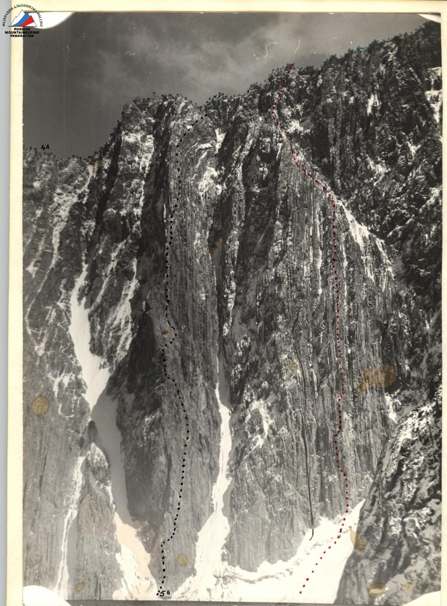 The route taken by the group. Route 5B category via the "STOLB" of the North ridge of SAGU peak. Part of the traverse 4A category SAGU–KHAMZA KHAKIM–De Niyazi.
Brief explanation of the table.
- R0–R1: Ice slope with a steepness of 45°, cut by a bergschrund about 1.5 m wide. The bergschrund is passed over a snow bridge.
- R1–R2: Severely destroyed rocks. The beginning of the route is limited on the left by a wide chimney, on the right by a rock gully resting against a cornice. The chimney and gully are rockfall-prone.
- R2–R3: Sheer monolithic wall with a limited number of holds and cracks. The last 10 m slightly overhang. Ladders were used to pass this section.
- R3–R4: Traverse under the overhanging wall to the left along destroyed rocks to a chimney divided along a narrow rock rib.
- R4–R5: Chimney about 1.5 m wide with an overhang. Soft destroyed rock. Protection gear was used for belaying. The chimney leads to a narrow inclined shelf. There is a possibility to gather two people. 1 control point.
- R5–R6: From the shelf to the left along the inner overhanging corner about 7 m long. The rocks are monolithic with a very small number of holds. From the corner to the left, bypassing the wall with a cornice, into a steep couloir about 3 m wide.
- R6–R7: Along the couloir, sticking to the right wall, along very fragile rocks to the wall blocking the couloir from above. Opportunities for organizing reliable belays are very limited.
- R7–R8: From the upper part of the couloir along the wall to the right to a vaguely defined tooth. Here it is possible to organize reliable piton belaying.
- R8–R9: From the tooth to the right into a chimney and further along its right part. Monolithic overhanging rocks. There are cracks for pitons of all sizes, and protection gear can also be used.
- R9–R10: From the chimney to the right to the top of the rib of one of the "per'ya". There is a platform for three people.
- R10–R11: Along a steep inner corner to an inclined talus shelf, shot through by stones flying out of a wide chimney on the right.
- R11–R12: Along the right wall of the "per'o" along severely destroyed rocks to an inclined talus shelf. "Koroba" and "shvellery" are used to organize belaying. There is a possibility of a sitting bivouac, but there is no water.
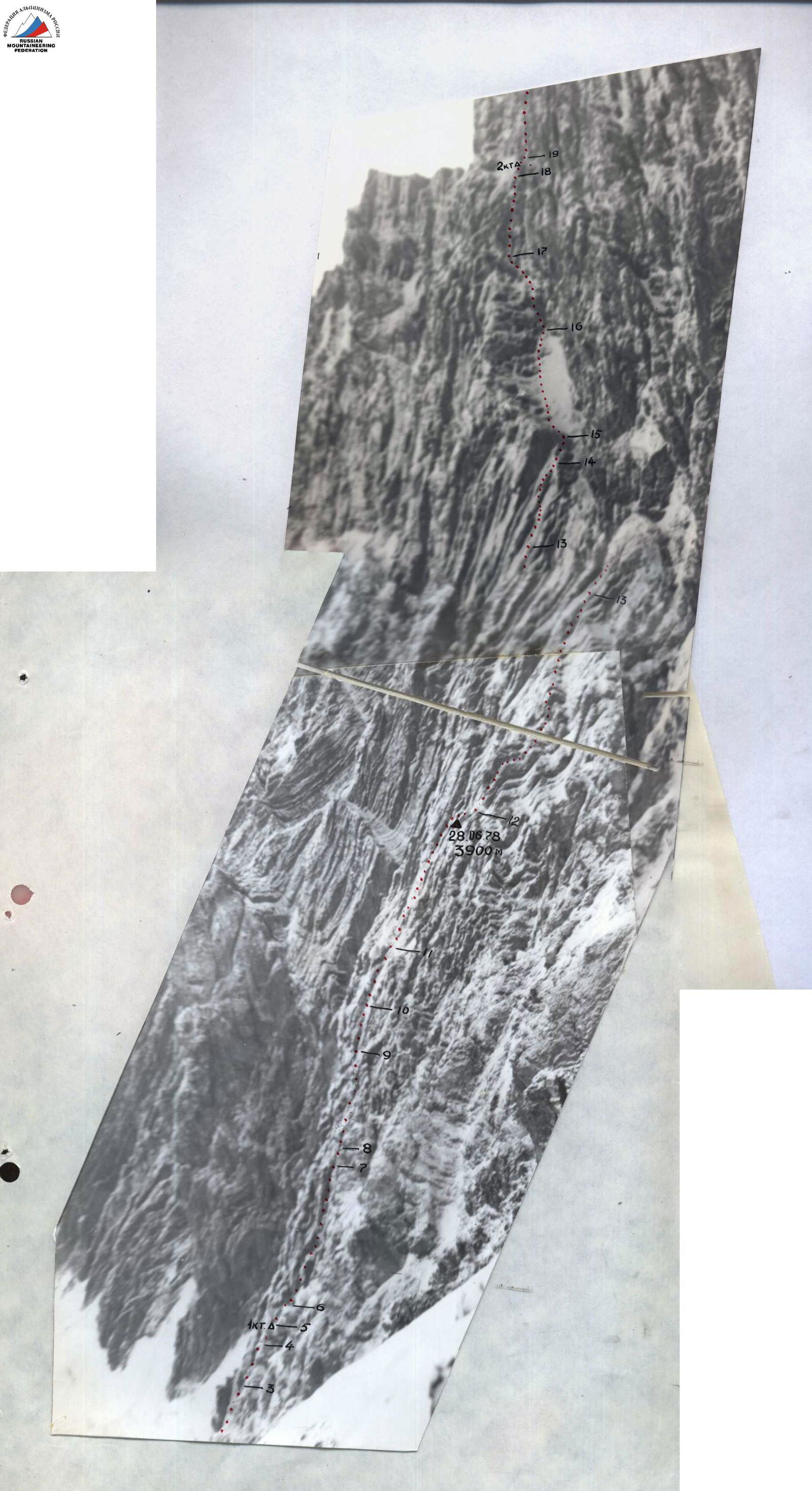
TABLE OF MAIN CHARACTERISTICS OF THE ROUTE first ascent to SAGU peak (4650 m) via the "per'ya" of the North ridge.
Route length: 1420 m (890 m to the ridge). Height difference: 1050 m (795 m to the ridge). Average steepness: 68° (to the ridge).
CHARACTER OF THE SECTION. PITONS
| Date | Designation | Steepness in ° | Length in m | Character of relief | Category of difficulty | State | Weather conditions | Rock | Ice | Protection gear |
|---|---|---|---|---|---|---|---|---|---|---|
| 27.06 | R0–R1 | 45 | 60 | ice | 3 | ice | clear | 2 | ||
| R1–R2 | 60 | 20 | wall | 5 | destroyed | – | 3 | – | – | |
| R2–R3 | 85 | 50 | wall | 6 | monolith | – | 11 | 3/2 | ||
| R3–R4 | 80 | 20 | wall | 6 | monolith | – | 2/1 | 3/1 | ||
| R4–R5 | 90 | 10 | narrow chimney | 6 | monolith | – | 2/1 | 0/2 |
Route processing from 15:00 to 21:00. Climbing hours 6. Bivouac under the route.
| Date | Designation | Steepness in ° | Length in m | Character of relief | Category of difficulty | State | Weather conditions | Rock | Ice | Protection gear |
|---|---|---|---|---|---|---|---|---|---|---|
| 28.06 | R5–R6 | 95 | 15 | inner corner | 6 | monolith | – | 2 | 2/2 | |
| R6–R7 | 60 | 85 | wide chimney | 5 | destroyed | – | 6 | 4 | ||
| R7–R8 | 80 | 5 | wall | 5 | destroyed | – | 3 | |||
| R8–R9 | 85 | 60 | chimney | 6 | monolith | – | 10 | 0/3 | ||
| R9–R10 | 90 | 20 | wall | 6 | monolith | – | 2/3 | 0/2 | ||
| R10–R11 | 70 | 40 | inner corner | 5 | destroyed | – | 5 | 4 | ||
| R11–R12 | 70 | 80 | wall | 5 | destroyed | – | 14 |
Departure at 9:00, stop for bivouac at 22:00. Climbing hours 13. Hanging bivouac.
| Date | Designation | Steepness in ° | Length in m | Character of relief | Category of difficulty | State | Weather conditions | Rock | Ice | Protection gear |
|---|---|---|---|---|---|---|---|---|---|---|
| 29.06 | R12–R13 | 65 | 120 | rib | 5 | large blocks | – | 10 | ||
| R13–R14 | 70 | 30 | slabs | 5 | monolith | – | 5 | 6 | ||
| R14–R15 | 50 | 15 | shelf | 5 | monolith | – | 3 | |||
| R15–R16 | 45 | 60 | talus couloir | 4 | destroyed | – | 3 | |||
| R16–R17 | 80 | 40 | wall | 5 | destroyed | – | 7 | 2 | ||
| R17–R18 | 45 | 50 | chimney | 4 | monolith | – | 5 | |||
| R18–R19 | 10 | 15 | ridge | 3 | monolith | – | belaying for ledges | |||
| R19–R20 | 65 | 110 | wall | 5 | icy destroyed | – | 18 |
Departure at 6:00, stop for bivouac at 19:30. Climbing hours 13. Bivouac lying down, in a tent.
| Date | Designation | Steepness in ° | Length in m | Character of relief | Category of difficulty | State | Weather conditions | Rock | Ice | Protection gear |
|---|---|---|---|---|---|---|---|---|---|---|
| 30.06 | R20–R21 | 20 | 350 | ridge | 4 | destroyed | – | belaying for ledges | ||
| R21–R22 | 45 | 180 | ice | 4 | ice | – | 3 |
Departure at 8:00. At 11:00 reached the summit of SAGU. Climbing hours 3.
- R12–R13: Along the rib of the "per'o" along partly destroyed rocks under steep black slabs with freely lying blocks.
- R13–R14: Along the slabs to the upper right corner under the overhanging yellow wall; the slabs are passed exclusively on friction. Further to the right to the left wall of a very large couloir separating the "per'ya" massif from the North wall of SAGU peak.
- R14–R15: Along the wall of the couloir along a narrow inclined shelf — exit to talus shelves in the upper part of the couloir. After the sun illuminates the North ridge of SAGU peak, this place is hit by stones.
- R15–R16: Along the left wall of the couloir along wide talus shelves and destroyed rocks under the wall closing the couloir.
- R16–R17: Along a steep destroyed wall 40 m under the base of an inclined chimney. The belay point is organized on an almost sheer wall. It is necessary to hang in the harness.
- R17–R18: Along the inclined chimney, on friction, exit to a rocky ridge crest connecting the "per'ya" massif to the wall of the North ridge of SAGU peak.
- R18–R19: Along the ridge crest about 15 m long under the wall. On the ridge crest is the 2nd control point.
- R19–R20: To the North ridge of SAGU peak, along which the 4A category route passes, leads an icy destroyed rock wall with a large number of "live" stones.
- R20–R21: Ridge with a large number of ledges, belaying is mostly simultaneous. On the ridge, it is possible to set up a tent in almost any place.
- R21–R22: Not very steep and complex ice, and the summit.