Passport
I. Class of ascent — technical.
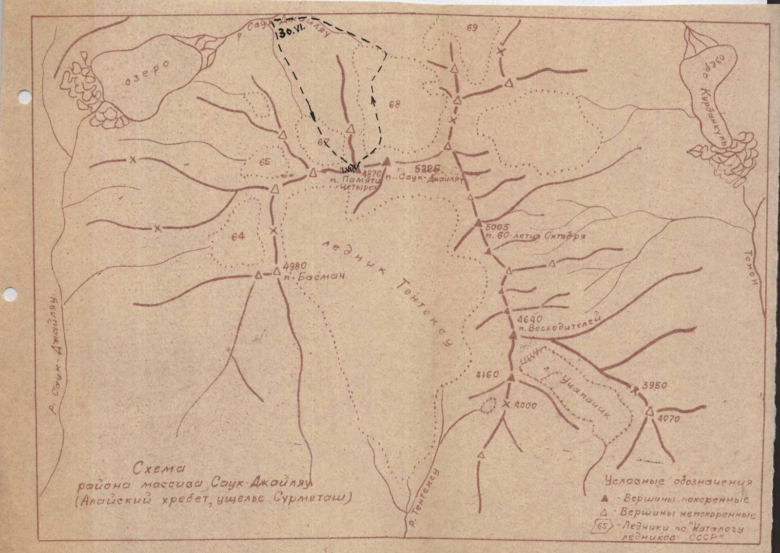
- Area of ascent, ridge — Sauk-Jailyau gorge, Alai ridge.
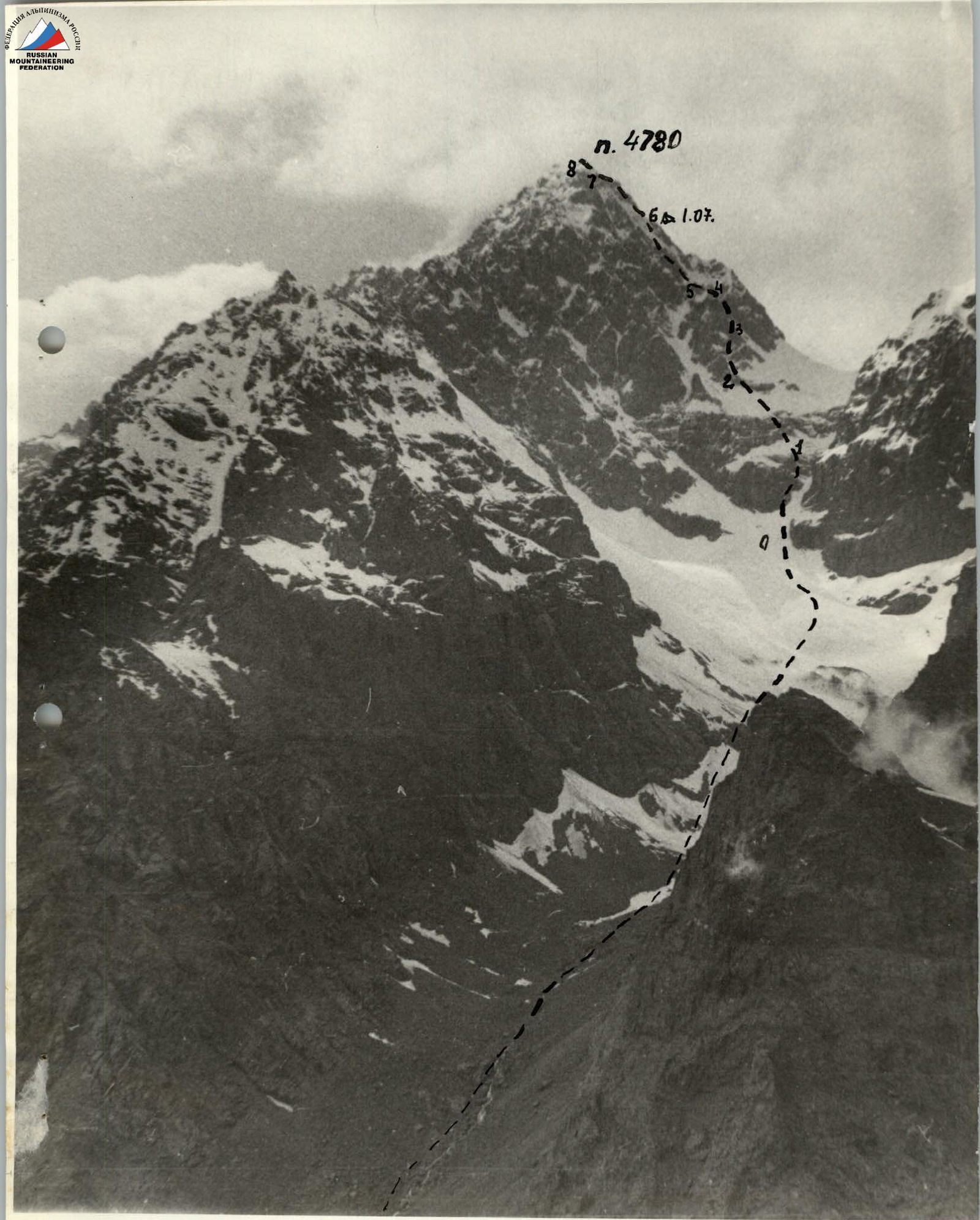
- Peak, its height, ascent route — p. 4870 (proposed name — p. Pamyati 4-kh) — from the southeast.
- Proposed difficulty category — 5A.
- Route characteristics:
height difference — 870 m. Length of sections R5–R6 cat. diff. — 650 m. Average slope 45°.
- Pitons driven — for belay, for creating, etc.
| rock — | 36 | — |
| ice — | 5 | — |
| bolt — | — | — |
- Number of travel hours — 17 hours.
- Number of overnight stays and their characteristics: one overnight stay on a platform cut out in the ice slope.
- Leader — G.V. Kalinin — Master of Sports
Participants G.Sh. Mulyukov — Candidate for Master of Sports, I.N. Labimsky — 1st sports category, V. Smirnov — 1st sports category.
- Coach — V.A. Elchibekov.
- Departure date — June 30, 1977, return date — July 1, 1977.
Description of the approach to the route
The approach to the route begins from a characteristic large table-shaped rock located on the bank of the Sauk-Jailyau River, 800 m above the lake. There are remains of a summer camp near the rock. From here, the dominant peak in the Sauk-Jailyau ridge is visible. This is peak "4870".
The approach to the route is made along the left-bank tributary of the Sauk-Jailyau River to the glacier located under the southeastern slopes of p. 4870.
The route begins in a couloir towards the eastern saddle of p. "4870" in the Sauk-Jailyau ridge.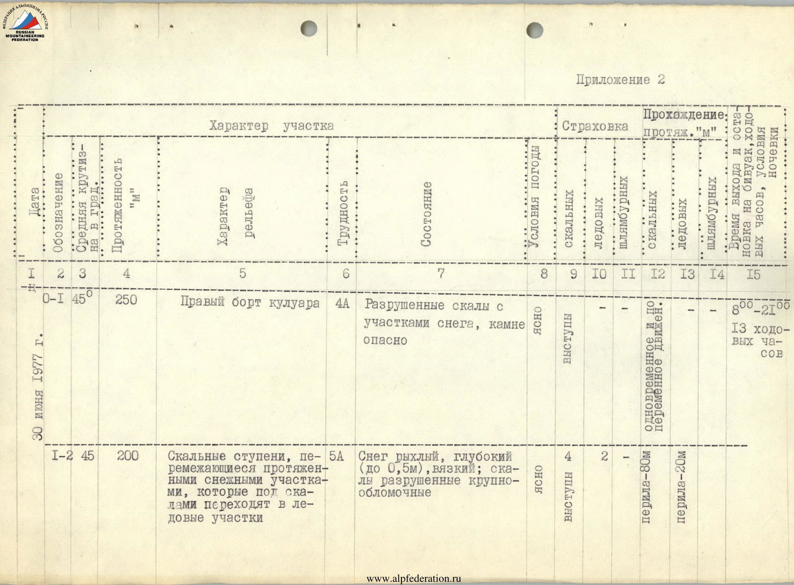
Appendix 2
| Date | Designation | Average slope in degrees | Length "m" | Terrain characteristics | Difficulty | Condition | Weather conditions | Belay (rock) | Belay (ice) | Belay (bolt) | Passage (Notes) |
|---|---|---|---|---|---|---|---|---|---|---|---|
| June 30, 1977 | R0–R1 | 45° | 250 | Right side of the couloir | 4A | Destroyed rocks with sections of snow, rockfall hazardous | Clear, exposed | 4 | 2 | — | Simultaneous and alternating movement. 1, rope-80 m. 8:00–21:00, 13 travel hours |
| R1–R2 | 45° | 200 | Rocky steps alternating with extended snowy sections, which turn into icy sections under the rocks | 5A | Snow is loose, deep (up to 0.5 m), viscous; rocks are destroyed, large-blocky | Clear, exposed | 4 | 2 | — | rope-20 m | |
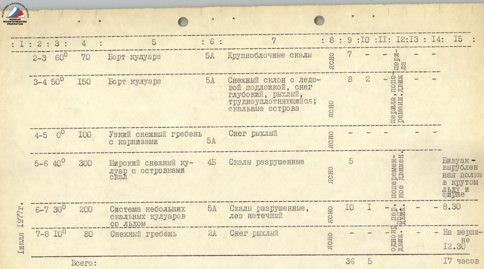
| July 1, 1977 | R2–R3 | 60° | 70 | Side of the couloir | 5A | Large-blocky rocks | Clear | 7 | — | — | rope, alternating movement |
| R3–R4 | 50° | 150 | Side of the couloir | 5A | Snow slope with ice substrate, snow is deep, loose, hard to compact; rocky outcrops | Clear | 8 | 2 | — | rope, alternating movement | |
| R4–R5 | 0° | 100 | Narrow snowy ridge with cornices | 5A | Snow is loose | Clear | — | — | — | rope-20 m | |
| R5–R6 | 40° | 300 | Wide snowy couloir with rocky outcrops | 4B | Rocks are destroyed | Clear | 5 | — | — | Alternating movement. Bivouac — a cut-out ledge in steep ice and firn. 8:30 | |
| R6–R7 | 30° | 200 | System of small rocky couloirs with ice | 5A | Rocks are destroyed, ice is frozen | Clear | 10 | 1 | — | Simultaneous movement | |
| R7–R8 | 10° | 80 | Snowy ridge | 2A | Snow is loose | Clear | — | — | — | At the summit 12:30 | |
| Total: | 36 | 5 | — | 17 hours |
Brief explanation of the table
The R0–R1 couloir is a natural chute for avalanches and rockfalls occurring on the upper slopes of peak 4870 m and the neighboring eastern peak (–4600 m). But its canyon-like shape with the presence of destroyed rocks on the right side (left as you ascend) allows passing this section without risk.
The R1–R2 section leads to the base of one of the disjointed rocky buttresses, the system of which leads to the summit; passing through them can be recommended to subsequent groups.
The R2–R3, R3–R4 sections — the side of the eastern couloir, very narrow with an avalanche groove. To avoid rockfalls and small avalanches, movement through the middle is not recommended.
The R4–R5, R5–R6 sections successively lead to the eastern ridge of peak 4870 m. On the R5–R6 section, it is possible to organize an overnight stay on one of the rocky outcrops.
The R6–R7 section — the upper reaches of small narrow icy couloirs on the southeastern side of the peak, the system of which merges into three couloirs below, one of which was ascended by the group. The descent from the summit was made initially through a couloir-chimney (80 m) to the southwest of the summit. This descent leads to a wide couloir starting from the saddle between p. 6870 m and Glavnaya Sauk-Jailyau. This 600-meter couloir leads to the southwestern glacier (see diagram).
For passing the described route or any other path from the southern side to peak 4870 m, as well as neighboring peaks, our group recommends taking:
- diverse, sufficiently long rock pitons;
- standard ice pitons (they can be used for driving into rocks).
Ascent leader — G. Kalinin.